UNIT 7 Geographic Information Systems (GIS) and Maps
Key Unit Competencies
By the end of this unit, you should be able to:
(i) Define and recognise basic features of GIS.
(ii) Differentiate the elements or components of the interface of the GIS application.
(iii) Query a map and organise map layers.
Learning Objectives
Knowledge and Understanding
By the end of this unit, you should be able to:
(i) Understand the basic concepts of GIS.
(ii) Identify different elements of the interface of an ArcMap.
(iii) Know how to work with maps in a GIS environment.
(iv) Know and understand how to use different navigation tools.
(v) Know how to identify a location using a query on a map.
Skills
By the end of this unit, you should be able to:
(i) Explain GIS related terms appropriately.
(ii) Explore the ArcMap environment.
(iii) Navigate a map and show a certain section of a map in different scales.
(iv) Query a map and organize map layers.
Attitudes and Values
By the end of this unit, you should be able to appreciate the importance and function of GIS
Keywords in the Chapter


Introduction
GIS is a system designed to capture, store, manipulate, analyze, manage, and present all types of geographically referenced data; that is, data identified according to their location. GIS applications are tools that allow users to create interactive queries (usercreated searches), analyze spatial information, edit data in maps, and present the results of all these operations. It is a computer-based system that stores geographically referenced data.
It links it with non-graphic attributes (data in tables) allowing for a wide range of information processing including manipulation, analysis, and modelling. A GIS also provides for map display and production. The GIS software is used to take descriptive words of places on earth stored in databases and spreadsheets and display them as map layers.
The data is geospatial, that is, for every point to be mapped there is a unique set of numbers, latitudes and longitudes that describe the place.
Geographic Information Systems cover the following areas among others:
• Natural Resources: This includes forestry management, habitat identification, and evaluation
. • Community services: Examples include fire, ambulance, police, crime investigations, and utility management.
• Health: Mapping the spread of infectious agents.
• Water resources: Planning water needs, and mapping aquifers among other services.
• Minerals: Mapping oil, coal, natural gas deposits, and copper among others.
• Education: Mapping population demographics and school distribution.
• Mapping natural phenomena: Examples are the occurrence of volcanoes, hurricanes, floods, and earthquakes.
Components of ArcGIS
ArcGIS Desktop contains a set of integrated applications. There are three ArcGIS desktop applications namely the ArcCatalog, ArcMap, and ArcToolbox.
(i) ArcCatalog: This application is used for managing spatial data contained in the computer and other locations, managing database designs, recording and viewing metadata. ArcCatalog allows previewing of documents, and organization of geographic data and creation of sophisticated geodatabases to store the data.
147
(ii) ArcMap: This is the main mapping application that allows the creation of maps and query attributes and analyzes spatial relationships and layout of the final projects. It helps in mapping and editing tasks, as well as for map-based analysis.
(iii) ArcToolbox: This application is used for data conversion and geoprocessing. These three applications can perform any GIS task, including mapping, data management, geographic analysis, data editing, and geoprocessing
Definition of Terms
Definition of Terms
• Java edition (AEJEE): AEJEE is an abbreviation for ArcExplorer–Java edition for Education. It allows viewing and querying local data as well as ArcIMS services from the geodata.gov or other hosted sites. AEJEE comes with several pre-packaged project files, as well as sample data to get one started. It is no longer supported by Esri (ArcGIS developer) but it still serves a valuable need for schools using computers with limited capacity.
• PostGIS: It is a free open source extension for PostgreSQL databases. It is used for storing, manipulating, and retrieving spatial data. It adds spatial functions such as distance, area, and intersection to the database.
• ArcExplorer: It is a lightweight data viewer. It performs a variety of basic GIS functions including display, query and data retrieval applications.
• Layers: A layer is a method used to display geographic data sets in ArcGIS. Each layer points to a data set and specifies how that data set is represented using symbols and text labels. The features in layers are related to one another. Data set is represented using symbols and text labels.
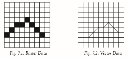
• Raster Data: These are items, usually images that are composed of pixels. The images may be extracts of satellite images, scanned maps, aerial photographs, or any object that shows pixels when enlarged. Figure 7.1 shows Raster Data.
• Vector Data: These are images such as streets, rivers, railway lines, lakes, city blocks, and any other features that can be drawn on a map. An example of vector data is shown in figure 7.2.
148
Assignment 7.1
1. Give five different areas where GIS can be applied.
2. Differentiate between:
(i) ArcMap and ArcGlobe
(ii) ArcCatalog and ArcScene
3. Define the following terms as used in GIS:
(i) Raster Data
(ii) Vector Data
(iii) Attribute
Learning Activity 7A
Do research on the Internet. Find out the type of institutions in Rwanda that are likely to be using GIS and maps. Find out the basic features of GIS they could be using.
The Interface of ArcMap
ArcMap can be opened from multiple locations. It can be opened from the Start menu or by use of an icon on the desktop.
To launch ArcMap, Click on the ArcMap icon pinned
 on the status bar.The startup window in figure 7.3 below appears.
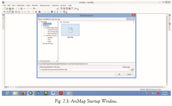
149
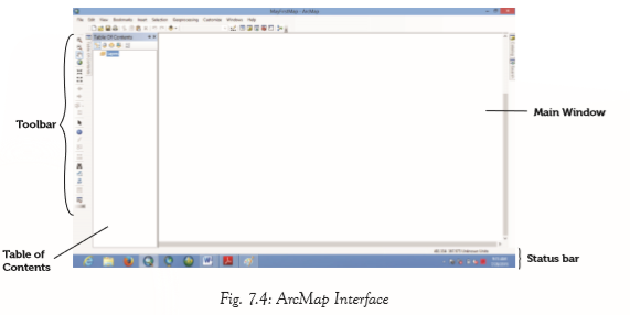
Click OK. The screen in figure 7.4 appears. The interface of ArcMap normally consists of Table of Contents (TOC), menu bar, status bar, main window, and toolbars.
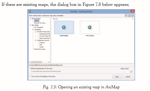
To open an existing map, select the map then click Open or double-click on the map. Clicking Cancel displays a blank window as shown in figure 7.6.
The following steps describe how one can open a new map using a template in an ArcMap:
(i) Start ArcMap by opening the Catalog window. The dialogue box in figure 7.6 appears
150

(ii) To open a new map, a template has to be chosen. Expand Templates and choose either from the Standard page sizes, from the Traditional layouts or Browse for more choices.
(iii) Clicking on World, displays the templates of the continents. Select the desired template, for example, Africa.

Click OK. The window shown in Figure 7.8 appears in the map display area of the ArcMap.
151
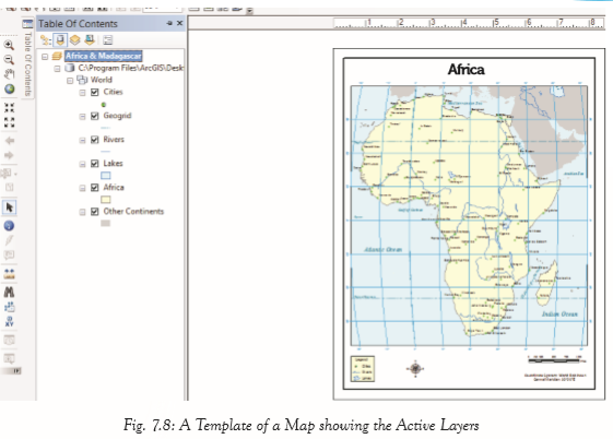
Table of Contents (TOC) The table of contents is used to manage the contents of the map display. it lists all the layers on the map. It also shows the features that each layer represents. The table of contents has the following command buttons:
(i) List By Drawing Order: The layers are listed by drawing order. Drag and drop to change the drawing order. When the layers tab is right-clicked, the commands are displayed.
152

• Add Data: The command is used to add new data to the maps in active data frame. Data can also be dragged into the map from the catalog window.
• New Group Layer: The command is used to add a new, empty group layer to the active data frame.
• New Basemap Layer: Adds a new, empty Basemap layer to the data frame. Abasemap layer is used to draw continously.
• Copy: Copies a dataframe(s) to the clipboard.
The menu bar
The Menu bar has options such as File, Edit, View, Bookmarks, Selection Geoprocessing, Customise, Windows and Help.
153

(a) The File Tab
The file tab enables the user to open a New window, open an existing file document, Save a document, save a document in a different location using Save As option, Save A Copy.., share a map package using Share as option, Add Data, Print, Print Preview, and Export Maps among other commands as shown in figure 7.10.
(b) The Edit Tab
The edit tab allows the user to Undo an operation, Redo an operation, Cut, Copy, Paste, Paste Special, Delete, and Copy map to clipboard among other operations as shown in figure 7.15.
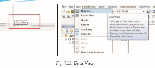
(c) View Tab
The view tab contains the Data View, Layout View, Graph and Scroll Bar, Status Bar, Reports and Data Frame properties among other options.
Data and Layout View
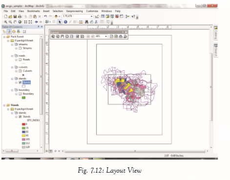
ArcMap provides two ways of viewing a map; data view and layout view. Each view allows one to view and interact with the map in different ways.
• Data View provides a geographic window for exploring, displaying, and querying the data on the map. The view allows one to work using real-world coordinates and measurements. If the map contains more than one data frame, the contents of the active data frame will be displayed.
• Layout View allows working with the map layout elements such as titles, north arrows, scale bars, and data frame among others.
154
(d) Bookmarks
Abookmark is an item you save to a map.
Bookmarks provide shortcuts to place on a map. When one clicks a bookmark the map zooms to that location.
155
Assignment 7.2
1. State the different ways of launching ArcMap.
2. Explain the function of the three command buttons in the Table of Contents for ArcMap.
3. What is the function of the Add Data button?
4. Explain how one can switch between Data View and Layout Vew in ArcMaps.
5. What is a bookmark.
Learning Activity 7B
Define the basic features of GIS.
File Handling with ArcMap
ArcCatalog organizes spatial data contained on the computer and various other locations. It also allows search, preview, and addition of data to ArcMap, as well as managing metadata and setting up address locator services (geocoding).
ArcCatalog: Data Management
To open the ArcCatalog, double-click on the ArcCatalog icon on the desktop, or from the Windows Start menu, select the ArcCatalog. Figure 7.25 shows the ArcCatalog Icon. After opening the software, the screen in figure 7.26 appears.
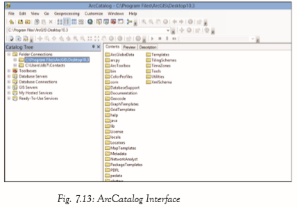
The screen lists a set of possible locations for data in the Catalog Tree. The screens may not look exactly the same. It is however easy to add directories for data by clicking on the ‘Connect to folder’ icon
 on the top left toolbar.
 156
Previewing Data
From the catalog tree on the left side, navigate to C:\Program Files\ArcGIS\Desktop 10.3\. A list of files will be displayed with various extensions. For example, the .shp extension of the file means that these files are in shapefile format and thus can be read by ArcGIS.
To be able to view file extensions, navigate to Customize, then select ArcCatalog Options and under the General tab unclick Hide file extensions and hit OK. Figure 7.27 shows Shapefiles as viewed in GIS data ArcCatalog. A combination of 3 to 7 individual files makes up a shapefile.

Description Tab
This tab provides an explanation of the files, spatial information, and a list of all of the attributes associated with a file.
Properties of Geographic Information Systems
(a) Location – Coordinates are used to give the exact location of an object.
(b) Attributes – Provides information about the location, for example, the population and the number of homes in a locality.
157
(c) Spatial Relationships – These are properties associating an object with other objects. These include the shape of the object and the relationship of an object with other objects.
Assignment 7.3
1. What is an ArcCatalog? Explain how it is different from an ArcMap.
2. Name and explain the different types of GIS files
3. Explain different properties of GIS.
Navigation Tools
The Basic Toolbar
Navigation is usually done using tools found in the basic toolbar. They are discussed as follows.
(a) Zoom In/Out: Zoom in is a tool used to enlarge the maps for a better view. To zoom in, click once on the Zoom In tool and then click anywhere on the map to be enlarged. Each click enlarges the map by a certain percentage. Zoom out is a tool used to reduce the size of the image
• To zoom out, click once on the Zoom Out tool and then click anywhere on the map. Each click on the map reduces the map by a certain percentage.
• Zoom in and zoom out can also be done by rolling the mouse scroll wheel in either direction.
(b) Fixed Zoom In/Out: Fixed Zoom in enlarges the image from the center of the page. To zoom, open the image and click on the Fixed Zoom In tool

• Fixed Zoom out reduces the image from the centre of the page. To zoom out, open the image and click on the Fixed Zoom Out tool .
• Fixed zoom in and zoom out functions can also be performed by rolling the mouse scroll wheel.
(c) Zoom to Full Extent: The tool zooms the image of the map to its full limit. After opening the map, click on the Full Extent tool

(d) Zoom to Previous/ Next: Zoom to previous tool takes the image back to the previous extent after navigating

• Zoom to the next extent takes the navigator go forward again through the sequence of extents one had viewed.
• The operations can also be performed using the < and > keys on the keyboard.
158
(e) Pan: Pan is to move an image horizontally or vertically from a stationary point in order to view from different angles. The map is panned by dragging on the screen.
• The pan tool
 can be clicked to re-centre the image or double-clicked to re-centre and zoom in. Holding down the C – key changes the cursor to the pan tool, then use the mouse to move the map.
• The map can also be moved by holding down the scrolling wheel of the mouse.
• To roam around the map, hold down the Q key or hold down the scrolling wheel of the mouse until the shape of the cursor changes, then roam as desired.
Query Methods
Query Using Find Tool
Find
 is a navigation tool used to search for locations using address or name of a place to find features that match particular attribute values and to find locations using linear referencing.
 Finding Features
To find Kigali from the map of Rwanda, do as follows:
(i) Click on the Find tool on the Tools toolbar. The find dialogue box shown in figure 7.15 below appears
 .
.
159Once the results of find are displayed, each feature can be navigated. Click an entry in the results list to flash it in the map (if it is within the map extent), double-click to Pan it (center the map on its location), or right-click to access a shortcut menu of the many operations that can be applied to the Find results.
Note: If one is using the default locator service from ArcGIS Online or another locator service on the web,
an Internet connection is required to use the Find tool.
Finding Locations
To find locations: (i) Click the Find tool to open the Find dialogue box and click the Locations tab. (ii) Identity the locator to be used. The window in figure 7.16 appears.
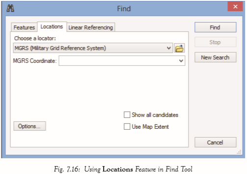
(iii) Enter the place name or address to be searched.
(iv) Click the Find button to search for and work with the results.
Linear Referencing
The Find tool can be used to locate events and observations with linear referencing onto line features. Linear referencing is the method of storing geographic locations by using relative positions along measured linear features.
One can find locations expressed as measures along routes. For example, one can find measures like the following;
160
• Find the point location of measure 20 along a certain route.
• An observation that starts at a measurement 36 and ends at 45.
Query Using Identify Tool
To view attribute values for a certain feature, use the Identify tool
 that can be accessed from the Tools toolbar. To use the Identify tool, follow the following steps;
 (i) Click the Identify tool on the Tools toolbar.
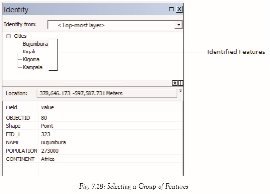
(ii) Click on a location in the data frame to identify the features at the location. The attributes are presented in the identify window as shown in figure 7.17.

(iii) Alternately, one can create a box to identify a group of features. Click on a location in the data frame, then drag to create a box. A window showing all the features within the selected box appears as shown in figure 7.31.
The attributes for the highlighted features are displayed at the bottom panel. Right – clicking a feature gives a drop-down menu shown in figure 7.32, that enables more operations such as zoom to, Flash, Pan to, Create bookmark Remove from Tree, Sort Ascending among other features to be performed.
161

162
Feature geometry is needed to use the Flash, Zoom To, Pan To, and Create Bookmark commands. In some cases, feature geometry is not available, so these commands are unavailable. These cases include the identification of features from any WMS layer and features from an ArcIMS image service that does not include geometry in any query results.
Assignment 7.4
1. Explain the function of the following tools as used in GIS:
(i) Fixed Zoom In
(ii) Pan 2. What is linear referencing?
3. Explain how the attribute values for Lake Victoria can be determined in GIS.
Choosing the Layers to Identify
By targeting layers to identify, one can focus on what is relevant when exploring a map. The Identify Tool can be customized to narrow down the amount of data to be seen by either filtering the layers one is interested in or customizing the field properties of those layers.
The Identify Tool identifies the topmost layer in your map by default. Use the Identify From list at the top of the Identify window to choose the specific layer(s) to identify. The following options can be used:
• Topmost layer: Identifies the attributes of the feature(s) from the layer that is highest in the table of contents drawing order and currently visible. The option does not identify features in a layer that is turned off in the table of contents or currently not being drawn because of the scale of the map. With this setting, one can get the attributes of the feature clicked on without getting the attributes of features in other layers that are drawn underneath that feature.
• Visible layers: It identifies the attributes of the features that are currently visible in your map.
• Selectable layers: It identifies the attributes of the features belonging to selectable layers. One can manage the list of selectable layers in the table of contents List by Selection view.
• All layers: It displays feature attributes for all map layers in the data frame regardless of whether they are in the display or not.
• A layer: Select a specific layer in your map. If you choose a particular layer, its features are identifiable even if the layer is currently turned off in the table of contents or currently not being drawn because of the scale of the map.
163
Revision Exercise 7
1. Define GIS.
2. Give some of the areas covered by GIS layers.
3. Explain at least three components of ArcGIS.
4. With reference to GIS, define the following terms:
(i) PostGIS
(ii) ArcExplorer
(iii) Layers
5. Explain the different kinds of vector data.
6. Give the steps for opening a new map using a template in ArcMap.
7. Discuss some of the command buttons found in the Table of Contents (TOC).
8. Differentiate the two methods of viewing of data under the view tab.
9. What is a bookmark? Explain how it can be created.
10. ArcMaps have some basic requirements for handling data frames, explain them.
168