General
- Geograpy SSE Y2 SB File Uploaded 2/11/21, 16:08
- Geograpy SSE Y2 TG File Uploaded 2/11/21, 16:07
UNIT 8 :WEATHER AND CLIMATE OF THE WORLD
Key unit competence: The student-teacher should be able to appreciate
the importance of the atmosphere, weather and
the impact of climate on the environment andhuman activities in the world.
Introductory activity
Read the following passage and answer the questions that follow:
The climate is defined as the average weather conditions of an area in terms of
temperature, atmospheric pressure, wind direction and wind speed, moisture,
cloudiness, precipitation, and sunshine for a standard period of 30 years.
Due to its high altitude, Rwanda enjoys a tropical temperate climate. The
average annual temperature ranges between 16 and 20° C, without significant
variations. Rainfall is abundant although it has some irregularities. Winds
are blowing with a speed of 1-3 m/s. With an economy that is dominantly
supported by agriculture.1. Referring to the passage above, establish the difference between the8.1. The atmosphere: definition and structure of the atmosphere
climate and the weather.
2. Establish the relationship between weather, climate and atmosphere on
Earth’s surface.
3. Examine the influence of climate on the environment and socio-economicdevelopment of Rwanda.
Activity 8.1
Observe the figure provided below and give answers to the questionsthat follow:
1. Identify on the illustration the major atmospheric structures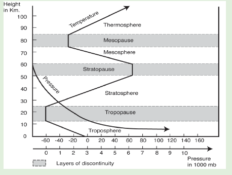
2. Describe different layers shown in the figure above.3. Examine the relevance of atmosphere to human?
8.1.1. Meaning of the atmosphere
The atmosphere is the envelope of gases surrounding the earth. It contains all
gases including those that support all forms of life on earth. This envelope of air
is dense at the sea level and becomes thin with the increase in altitude.
8.1.2. The structure of the atmosphere
The atmosphere is made up of four vertical layers namely the troposphere, thestratosphere, the mesosphere and the thermosphere.
(i) Thermal characteristics of the atmosphere
Based on temperature variation, the four layers of the atmosphere (troposphere,
stratosphere, mesosphere and thermosphere) represented on the followinggraph, are briefly described in the next paragraphs.
(i) Troposphere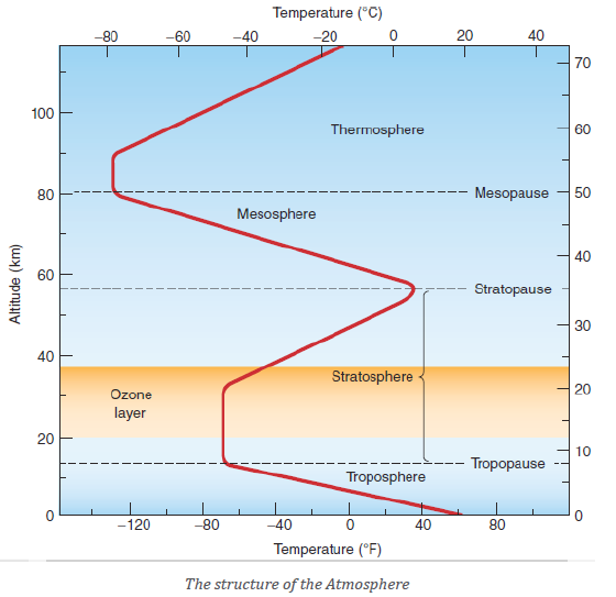
The troposphere is the lowest layer of the atmosphere; it lies between 10 and
20 kilometres above the sea level. The upper limit of the troposphere is the
Tropopause. The temperature decreases with increased altitude at a rate of
6.50c per 1000 m. Most of weather phenomena occur in this layer, which makesthe troposphere vital to the survival of both fauna and flora.
(ii) Stratosphere
The stratosphere extends from 16 to 50 km above the sea level. There is
an increase of temperature in this layer due to absorption of ultraviolet
solar radiation by the ozone layer. There is nearly the absence of weather
phenomena because of dry air and rare occurrence of clouds. The upper limitof the stratosphere is called Stratopause.
(iii) Mesosphere
The mesosphere extends between 50 km and 80 km above the sea level.
Temperature decreases with increased altitude reaching nearly - 1000 C at the
upper limit of this layer; the Mesopause.
(iv) Thermosphere
This atmospheric layer extends from 80 km to 640 km. It is composed of
Ionosphere and Exosphere.
a) The ionosphere is moistless and dustless. It consists of several ionized
layers which transmit radio and television waves.
b) The exosphere represents the uppermost layer of the atmosphere. The
density of the air becomes extremely low. The temperature reaches more
than 1700° C at its outer limit. The atmosphere above the ionosphere
is called the outer atmosphere and it is made of exosphere and the
magnetosphere.
8.1.3. Composition of atmosphere
Basically, the atmosphere is composed of Nitrogen which is the most abundant
gas with 78.1% of the totality of the Atmosphere followed by Oxygen 20.9%,
Argon 0.93%, Carbon dioxide 0.03% and others occupy the remaining portion
of the atmosphere.
8.1.4. Importance of the atmosphere
The atmosphere is important for the following reasons:
• It protects living things from harmful ultraviolet rays of the sun. This
role is played by the ozone layer.
• It helps to regulate the heat during the day and night. On earth,
however, molecules in the atmosphere absorb the sun’s energy as it
arrives, spreading that warmth across the planet.
• The atmosphere protects and sustains the Earth planet’s inhabitants
by providing warmth and absorbing harmful solar rays.
• It provides the various gases that are useful to living things, such as
among others, oxygen carbon dioxide.
• It provides precipitation that helps to sustain life on earth.
• The atmosphere is a crucial part of the water cycle and is an important
reservoir for water and the source of precipitation.
• The atmosphere moderates Earth’s temperature because greenhousegases absorb heat.
Application Activity 8.1
1. (a) Explain why the atmosphere should be conserved.(b) Describe how atmosphere should be conserved.
8.2. Elements of weather and climateActivity 8.2
Definition of weather and climate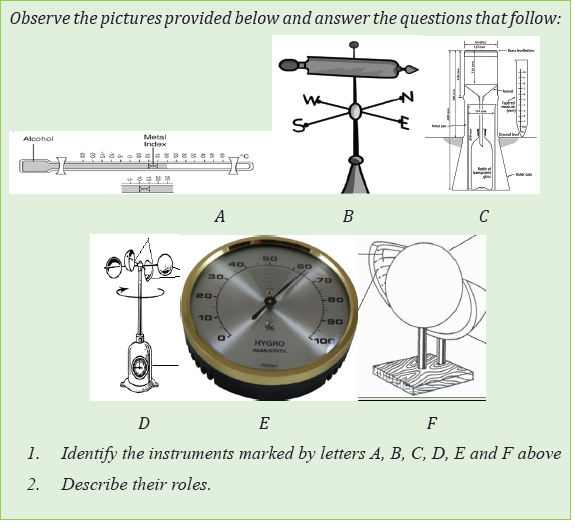
Weather is defined as the state of the atmosphere at any given time. Weather
keeps changing all the time. The change is from hour to hour and day to day.
Climate is an average weather conditions of atmosphere of a given place over
long period of time (about 30 years).
The elements of weather and climate: Weather and climate are observed
from their elements. The main elements are temperature, precipitation, wind,atmospheric humidity, clouds, sunshine and atmospheric pressure.
8.2.1. Temperature
Activity 8.2.1
Read the context below and answer the questions that follow:
When people migrate from Bugesera to Musanze they are required to
change clothing style. Some of them say that it is necessary to put on
jackets due to climatic conditions of that area.1. Why is there constant change of clothing style from Bugesera toTemperature is the degree of heating and cooling of the atmosphere at a given
Musanze?
2. Identify the weather condition that lead people to put on jackets in
Musanze while in Bugesera they put on T-shirts.
3. What may be the possible causes or factors responsible for thatconstant change of the weather?
area and time.
(i) Factors influencing temperature variation
Temperatures change from place to place. These changes are caused by different
factors which include the following:
1) Latitude: The amount of sunshine received decreases as one moves
away from the Equator since the equator and the nearby places receive
the overhead sun whereas areas beyond tropics never experience the
overhead sun.
2) Altitude: Temperatures decrease with increasing altitude from the
earth’s surface towards troposphere, at the normal rate of 6.5°C per
1000 metres ascent.
3) Distance from the sea: Places nearby large water bodies usually receive
cooler temperatures than places far away from the coast due to the effect
of land and sea breezes.
4) Prevailing winds: Winds blowing from low latitudes to high latitudes
raise the temperature of the regions where they reach. Winds blowing
from high latitudes to low latitudes lower the temperature.
5) Nature of land and water: Land becomes warm and cold more quickly
than the water body; this is because water has the capacity of absorbing
and storing sun energy which is transformed into heat.
6) Nature of ground surface: The nature of ground surface in terms of
colour, vegetation, and land use practices determines the reflection or
absorption of sun energy and affects distribution of temperature. Areas
under vegetation absorb more heat from the sun than those without
vegetation.
7) Nature of ground slope: The slopes facing the sun receive more heat
from the sun because its rays reach the surface more or less straight.
8) Cloud cover: Cloudy nights and days are warmer than cloudless
nights and days because cloud does not allow heat to escape from the
atmosphere.
9) Ocean currents: The warm Ocean currents flowing from tropical areas
to temperate and cold zones raise the average temperature in the affected
areas.
(ii) Measurement and recording of temperature
The instrument used for recording temperature is called a thermometer.
Temperature is measured in degrees Celsius (°C). The line on the map joining
places with the same temperature is called isotherm.
The three common types of thermometers the most include:
• Maximum thermometer (records the highest temperature of the day)
• Minimum thermometer (records the lowest temperature of the day).
• Six’s thermometer (records both maximum and minimum temperatureof the day).
(iii) Terms related to temperature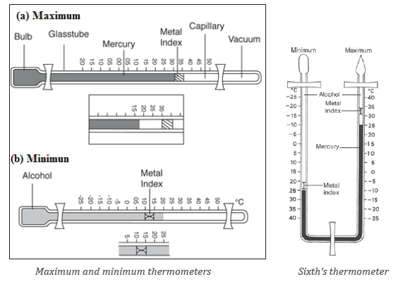
• Mean temperature
The following are types of average temperature:
Diurnal average temperature represents the average temperature within
24 hours of the day.
It is obtained by adding the hourly temperatures and dividing the total by
24 (hours).
The highest temperature recorded within 24 hours is called the daily
maximum temperature.
The lowest temperature recorded within 24 hours is called the daily
minimum temperature.
• Monthly mean temperature: This is the sum of mean daily temperatures
for a given month divided by the number of days of that month.
• Annual mean temperature: This is the sum of the monthly mean
temperatures divide by 12.
• Temperature range
── The difference between the maximum and minimum temperatures of
the day is called diurnal temperature range (DTR).
DTR= maximum T0- minimum T0.
── The difference between maximum and minimum temperatures of the
year is called annual range of temperature (ATR).
ATR= maximum monthly T0- minimum monthly T0
(iv) Impact of temperature on the environment
The following are the major impacts of temperature on the environment:
• A rise in global temperatures leads to an increase of evapo-transpiration.
This could eventually lead to the rise in amount of rainfall which impact
on environment.
• A rise of temperature leads to melting of glaciers in polar and
mountainous regions or ice-capped highlands.
• An increase in temperature leads to global warming which impacts
negatively on the environment.
• As the earth gets warmer, plants and animals that need to live in cold
places like on mountain tops or in the Arctic, might not have a suitable
place to live.
• The sea level has been rising more quickly over the last century as a
result of temperature change.
• Precipitation (rain and snowfall) has increased across the globe; onaverage as a result of temperature change.
8.2.2. Precipitation
Activity 8.2.2Observe the illustration provided below and answer the following questions:
1. Identify the types of precipitation shown on the above picture.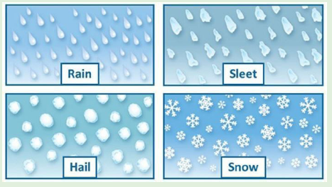
2. Distinguish the formation of rain from that of snow.
i) Meaning and forms of precipitation
Precipitation is any form of liquid or solid water particles that fall from the
atmosphere and reach the earth surface. The following are main forms of
precipitations:
• Rainfall is the most widespread and important form of precipitation.
Rain refers to liquid water droplets falling from the atmosphere under
the influence of gravity.
• Hail: It consists of large pellets or spheres (balls) of ice falling from the
atmosphere.
• Sleet: It refers to mixture of snow and rain.
• Snow: snow appears as very small crystals of ice suspended in the
earth’s atmosphere. Snow occurs when condensation occur below 00C.
• Fog: This is a cloud layer lying in contact and very close to the surface of
the earth or sea.
• Frost: It is defined as transformation of water vapour directly into
solid form at the ground surface due to condensation occurring below
freezing point.
• Dew: These are droplets of water that are deposited on the ground.
They are mostly present on plant’s leaves in the morning.
• Rime: It is an opaque thin, white layer of ice that forms when the air
temperature is below the freezing point of water, especially outside at night.
(iii) Types of rainfall
Rainfall is precipitation in form of droplets. The following are the major forms
of rainfall.
1. Convectional rainfall: It occurs when the earth’s surface is heated by
the sun. The warm air rises, and it is replaced by the cold air. As the air
rises, the pressure on it decreases, expands and cools. Further cooling
makes the moisture in it to condense and form clouds. It later falls as rain.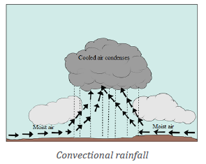
2. Orographic rainfall
This type of rainfall occurs when a water body is heated by the sun. The heating
causes evaporation. Moist air from the sea blows over a hill or mountain side.
The rising causes it to expand and cool. It condenses and forms clouds. Rainfall
occurs on the wind ward side of the mountain. This is the side facing the moistwind. The opposite side known as leeward side is dry.
3. Cyclonic or frontal rainfall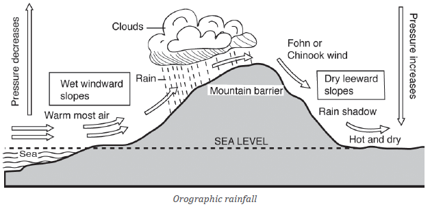
Cyclonic or frontal rainfall occurs when air masses of different temperatures
meet. One is warm and the other is cold. The warm air is forced over the cool
air. As the warm air rises, the moisture in it is cooled. It condenses and falls as rain.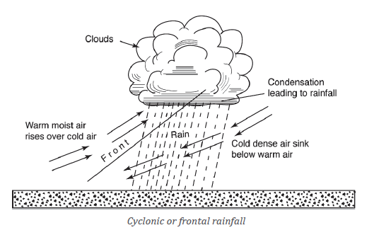
i) Factors influencing rainfall formation
Precipitation of different areas of the globe is influenced by different factors
which include the following:
• Moisture content of the air: The atmospheric moisture depends on
evaporation of water, regions having high temperature and abundance
of surface water, and wide-open Oceanic surfaces for evaporation,
receive higher amount of annual rainfall.
• The convergent or divergent air circulation: The convergence
of two contrasting air masses creates frontal activity and result into
cyclonic rainfall.
• Topographic conditions: Topographic conditions present favourable
conditions for precipitation. Moist air is forced by mountains to ascend
and condense hence yielding precipitation.
• Distance from the sea: Distance from the source of moisture
determines the amount of rainfall in different areas. Places near the
water bodies receive increased precipitation compared to areas far
away from the sources.
ii) Measurement and recording of rainfall
Rainfall is measured using a rain gauge. Most consist of a circular collector and
a funnel that channels the collected rain into a measuring mechanism or into
a cylinder where it may be measured later. The entrance to the gauge through
the funnel is narrow to avoid debris clogging the mechanism and undesirable
evaporation in hot weather. To make the rainfall measurement, the observer
empties the collected rain into a graduated glass rain measure. Lines on the
map joining areas with the same precipitation are called isohyets.
iii) Terms related to rainfall
The data obtained from the weather station can be used to calculate the
following:
• Monthly rainfall total: This is the total amount of rainfall received in
a month. It is obtained by calculating the sum of daily rainfall totals in
the month.
• The annual rainfall total: This is the total amount of rainfall received
in a year. It is obtained by finding the sum of all the monthly rainfall
totals for 12 months.• Mean annual rainfall: it is calculated by adding the monthly totals.
8.2.3. WindsActivity 8.2.3
Observe carefully the picture provided below:
1. Explain the phenomenon occurring on the above picture.
2. Describe the factors causing the mentioned phenomenon in (1).
3. Suggest the instrument used to record the direction and speed of wind.
(i) Meaning of wind
Wind is air in motion above the surface of the earth. It is caused by differences
in atmospheric pressure. Air moves from areas of high atmospheric pressure to
areas of low pressure.
(ii) Measurement and recoding of wind direction and speed
The wind direction is measured with help of a wind vane and wind sock, while
the anemometer serves to measure the speed of the wind. These instruments
are represented in Figure
Wind vane: It consists of a horizontal rotating arm pivoted on a vertical shaft.
The rotating arm has a tail at one end and a pointer at the other. When the wind
blows, the arm swings and points to the direction the wind is blowing from. Thewind is named after this direction.
Wind sock: It is common in airstrips. It consists of a cylindrical cloth bag tied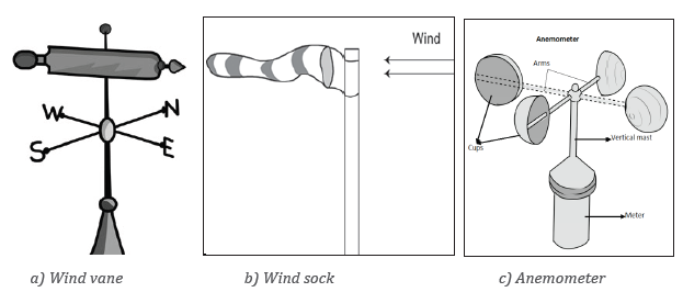
to a mast. It always points towards the direction at which the wind is blowing.
Anemometer is used to measure the speed of wind. This instrument consists
of three or four metal cups fixed to metal arms that rotate freely on a vertical
shaft. When there is wind, the cups rotate. The stronger the wind, the faster
the rotation will be. The speed of rotation is recorded on a meter. Wind speed
is measured in kilometres per hour (km/hr). The regions with the same wind
speed are called isotaches.
(iii) Types of winds
Winds are classified into 3 major categories namely local winds, prevailing
wind and air masses.
a) Local winds are winds that blow over a small geographical area and
normally for a short period of time. The examples of these include land and
sea breezes, valley and mountain breezes and etc.
• Sea breezes: Land heats up faster than the sea during the day. Air over
the land, therefore, becomes warmer than over the sea. The lighter and
warmer air rises. The cooler and heavier air from the sea moves over the
land to replace the rising air. This movement of air causes a sea breeze.
• Land breezes: At night, the land cools faster than the sea. The air over
the land becomes cooler and heavier than the air above the sea. The
warmer air over the sea is lighter. It rises while the cooler heavier air
over the land moves to replace it. This creates an air current called aland breeze.
• Valley breezes: The slopes and floors of valleys are heated more at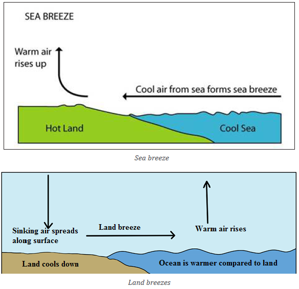
daytime. The warm air moves up the slope or upwards. This movement
creates what is called a valley breeze or anabatic wind.
• Mountain breezes: During the night, the hill slopes lose heat faster. The
valleys remain warmer. A low-pressure gradient is created in the valley.
Air current moves down the valley to form what is known as a mountainbreeze. It is also called katabatic wind.
There are many other examples of local winds like Chinook, Sirocco, Harmattanwhich affect different parts of the world.
b) Permanent winds, also called prevailing or planetary winds are those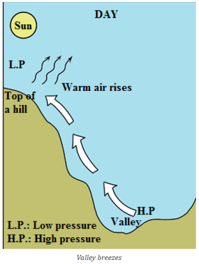
that flow from a known high pressure area to low pressure area throughout
the year. Prevailing winds are large masses of air having fairly uniform
humidity and temperature.
Permanent winds include:
─ Easterlies: There are winds which blow from East to West. These are
found in both inter-tropical zone and polar zone. The winds blowing
in inter-tropical zone are also called trade winds.
─ Westerlies: These types of winds blow from West to East. They are
found in the temperate zone between tropics and sub-polar zone.The locations of planetary winds are illustrated on the following figure:
c) Air masses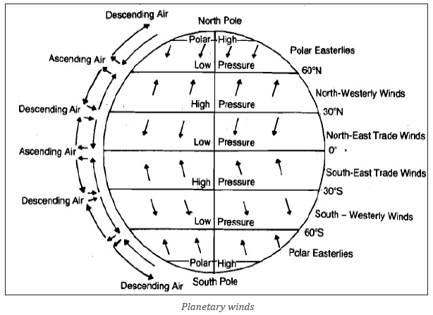
Air mass may be defined as a large body of air whose physical properties,
especially temperature and moisture content are uniform horizontally for
hundreds of kilometres. Air masses originate mainly from large areas with
uniform properties like desert, seas and oceans. There are therefore two broad
categories of air masses which are continental air masses and maritime air
masses.
iv) Influence of winds on weather conditions and human activities
Influence of winds on weather conditions
• The movements of the air affect the weather of surrounding zones.
Winds transfer heat and cold temperatures from one place to another
• Wind and ocean currents are the vehicles of water vapour which lead to
cloud formation which yield rainfall.
• The wind direction will have an important influence on the expected
weather. Wind direction changes often accompany changes in the weather.
• The wind speed and direction can give the clues to the expected weatherconditions.
Influence of winds on human activities
• The winds with high speed cause the destructions of physical and
human-made environment (e.g. Hurricanes, tornadoes, typhoon, etc.).
• Trees are bent under the wind effects and, sometimes this causes
accidents on the neighboring buildings and electric poles.
• Exposure of growing plants to warm wind results in dwarfing due to
dryness of plant tissue
• Wind increases evapotranspiration due to removal of accumulated
humid air near the leaves crop water requirements by.
• Moderate wind aids effective pollination. Strong wind during flowering
reduces pollination causes flower shed, increases sterility and reduces
fruit set in all crops.
• Wind speed more than 50 km per hour leads to destruction of crops
leading to heavy loss.
• Soil and sand particles blown by wind strike the leaves making punctures,
abrasions, scratches and tear the leaves into pieces and strips.
• The coastal area affected by strong winds faces the challenge of high
salinity due to salt particles drawn and deposited on the mainland. This
makes the soil unsuitable for growing plants.
• The crops on the windward slopes yield more because the constantsupply of moisture by warm winds from water bodies.
8.2.4. Atmospheric humidity
Activity 8.2.4Observe the diagram below and give answer to the questions that follow:
1. With reference to the knowledge and skills acquired from previous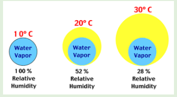
lessons; differentiate the above types of atmospheric humidity.2. Explain the significance of atmospheric humidity to the environment.
(i) Meaning of atmospheric humidity
Atmospheric humidity is the amount of water vapour in the atmosphere. The
water comes as a result of hydrological cycle.
(ii) Measurement and recording of humidity
Atmospheric humidity is measured using a hygrometer. This instrument
consists of a system of levers connected to a pen and record chart or graph
paper. Within the hygrometer system there are threads of human hair. When
humidity rises, the threads stretch and absorb moisture, whereas whenhumidity falls, threads dry and thin.
(iii) Types of atmospheric humidity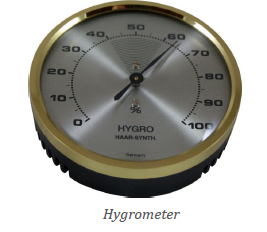
The following are the main types of the atmospheric humidity:
• Absolute humidity is defined as amount of water vapour per unit
volume of air at a given temperature. It changes with changing
temperature, and is expressed in gram per cubic meter volume of air
(gr/m3).
• Relative humidity refers to a ratio of the air’s actual water vapour
content and the total amount of water vapour air can hold at that
temperature and pressure. Relative humidity is generally expressed aspercentage. Relative humidity is calculated as follows:
(iv) Factors influencing atmospheric humidity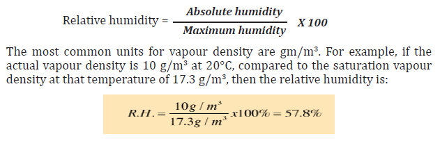
The following factors affect humidity:
• Temperature: An increase in the temperature of the air increases its
ability to hold moisture.
• Amount of water available: There is more evaporation over the Ocean
than the land. Therefore, there is more moisture over the Ocean than
the land.
• Wind-speed: Evaporation depends on the speed of wind. When the
winds are light, a thin layer of air just above the surface gets almost
full of moisture. When the wind speed is high, the air has less moisture.
• Area of the evaporating surface: Larger areas where evaporation
occurs increase the rate of evaporation.
• Mineral composition of water: The rate of evaporation is always
greater over fresh water than over salty water.
(v) The importance of humidity to environment
• It facilitates the weather fore casting. It is not possible to forecast
the weather exactly without precise knowledge of humidity in all the
layers of the atmosphere.
• Correct relative humidity is important for our well-being and health.
• It enables the hydrological cycle to operate normally. It enables much
water in form of vapour to be kept or stored in the atmosphere. Such is
condensed later to form precipitation.
• Water vapour is a key agent in both weather and climate, and it is an
important atmospheric greenhouse gas. This plays part in regulating
the Earth’s temperature.
• Humidity measurements contribute both to achieving correct
environmental conditions that sustain various ecosystems.
• Humidity drives most of the observable weather phenomena starting
with clouds, fog, rain, storms and finally to such dramatic weatherconditions such as hurricanes.
8.2.5. Cloud cover
Activity 8.2.5
Read critically the text below and answer the questions that follow:
Daniella always wakes up and observes the horizon of the sky. One day,
she observed the sky and found out that it was clear with white colour.
She continues to take note of the daily occurrences of the nature of the sky.
The next day she observed black colour in the sky, another day she found
sky approaching the tops of hills and the last day of her last observation;
she observed the sky being dark and reaching the ground. Now Daniella is
asking herself what is happening in the sky.
Help Daniella to be satisfied with clear explanations to her question
through answering the following questions:1. Explain what causes the different colours that arise in the horizon(i) Meaning of cloud
of the sky.
2. Describe the effects of the last observation of Daniella to theenvironment.
A cloud is an aggregation or grouping of moisture droplets and ice crystals that
are suspended in the air.
(ii) Types of clouds and their characteristics
Clouds are classified according to altitude and form. With regard to form, there are:
• Stratus clouds: These are layered clouds. They look like blankets and
cover large areas. They can give large amounts of rain or snow.
• Cumulus clouds: These have bubble-like bodies. They give rain over a
small area.
• Cirrus clouds: these are composed of small ice crystal which are white,
fibrous and feather like.
With regard to altitude, clouds are classified as:
• High clouds (form 6,000 m above the sea level). They look like feathers
and appear in separate groups in fair weather. In bad weather, they are
concentrated. Examples include:
─ Cirrus
─ Cirrostratus─ Cirro-cumulus
• Middle clouds (between 4,000 and 6,000 metres of altitude). They are
thick clouds. Examples include:
─ Alto-stratus
─ Alto-cumulus
They are mostly distributed over the whole sky. They appear white or grey.
• Low clouds (Below 2,000 metres). They are usually shallow. Examples
include:─ Stratus: They are dense, low-lying fog-like clouds of dark grey• Clouds with great vertical extent: They are found between 2,000 and
colour. They are composed of several uniform layers.
─ Strato-cumulus: They are generally associated with fair or clear
weather but occasional rain or snow.
─ Nimbo-stratus (Ns): They are middle and low clouds of dark colour.
They are associated with rain.
10,000 metres. They are white but may appear grey or black. They give
heavy rainfall. The following are examples:
─ Cumulus (Cu) which are very dense, widespread and dome-shaped
clouds. They also have flat bases and are associated with fair
weather. These sometimes are characterised by thunder.
─ Cumulo-nimbus (Cb) are thunder-storm clouds and produce heavy
rain, snow or hailstorm accompanied by lightning, thunder and
gusty winds. They exhibit a well-developed vertical extent. Theyappear like mountains or huge towers.
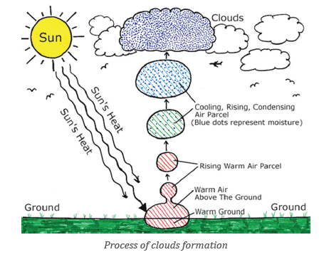
(iii) Factors influencing the formation and the shape of clouds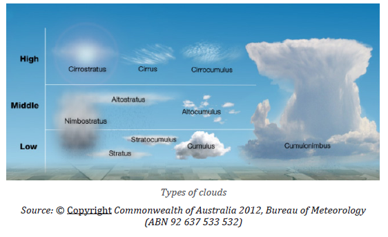
The sun plays a major role in formation of clouds. The first step of cloud
formation is related to the rising of the air into the atmosphere. Such air must
be moist or carrying water vapour that is later condensed to form clouds. The
following are the major factors influencing the rise of air into the atmosphere:• Sun: The sun heats the earth and thus the air rises, expands, and cools.
• Topography: Clouds are also formed when air encounters mountains
or other raised topography. The air rises and cools, condensing to form
clouds.
• Clouds can be formed when air rises along the slope of a mountain.
This aids the moist air to reach the atmosphere where it cools down,
condensing and as a result, clouds are formed.
• Warm and cold fronts: Weather fronts cause the rise of the air.
Specifically, warm fronts make the air to condense because the warmair rises above the cold air. This results into the formation of clouds.
(iv) Effects of clouds on weather
The clouds are much important on weather conditions prevailing in a given
area as it is explained below:
─ During the day, the earth is heated by the sun. If skies are clear, more
heat reaches the earth’s surface. This leads to warmer temperatures.
─ If sky is cloudy, some of the sun’s rays are reflected back into space.
Little sun’s energy manages reaches the earth’s surface which causes
the earth to heat up more slowly.
─ The clear sky during day, leads to increase in temperature. At night,
cloud cover has the opposite effect. If skies are clear, heat emitted
from the earth’s surface freely escapes into space, resulting in colder
temperatures.
During a cloudy time, some of the heat emitted from the earth’s surface is
trapped by the clouds. This heat is reemitted back towards the earth. As a result,temperatures decrease more slowly than if the skies were clear.
8.2.6. SunshineActivity 8.2.6
Observe the following illustration and give answers to the questions thatfollow:
1. Describe what is presented on the above illustration?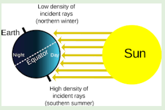
2. Arrows on the illustration show solar radiation reaching the earth
surface, explain the factors influencing the amount of solar radiation
in an area.3. Explain the negative effects of solar radiation on the environment.
(i) Meaning of sunshine
Sunshine refers to the energy emitted by the sun in form of rays. The sunshine
is observed and recorded during the day time.
(ii) Measurement and recording of sunshine
This is done using a Campbell-stokes sunshine recorder. The instrument
records the duration and intensity of sunshine. A line on the map joining placeswith equal sunshine is called isohel.
(iii) Factors influencing the amount of solar radiation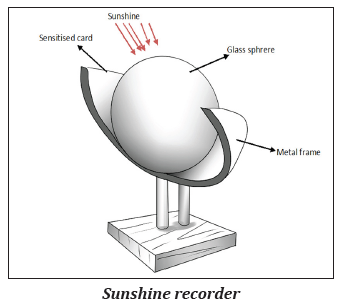
Solar radiation is not equal distributed all over the zones of the Earth due to the
following factors:
• Angle of the sun’s rays: The angle of the sun’s rays decreases as one
moves towards the poles, and vertical rays are associated with more
solar radiation,
• Length of the day: The shorter the duration of sunshine, longer the
period of night. This results into lesser amount of solar radiation
received at the earth’s surface and vice versa.
• Distance between the Earth and the Sun: The distance between the
sun and the earth changes during the course of a year. This is because
the Earth revolves around the sun in an elliptical orbit. At the time of
perihelion (on January 3) the earth is nearest to the sun while at the
time of aphelion it is farthest from the sun. At the time of perihelion,
the earth should receive maximum insolation while at the time ofaphelion it should receive minimum insolation.
─ Effects of the atmosphere: As solar radiation travels a long distance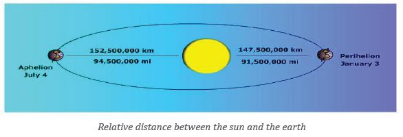
from the sun to the earth’s surface; there are some portions of the
solar energy which are lost through the processes of reflection,
diffusion, absorption and scattering.
(iv) Influence of sunshine on the environment
The sunshine has both positive and negative effects on the environment, as
briefly described in the following paragraphs:
Positive effects
─ Health benefits: Humans require between 1,000 and 2,000 units
of vitamin D daily for optimum health. The skin creates vitamin D
naturally when exposed to solar radiation.
─ Needed for photosynthesis: Sunshine is needed in photosynthesis
processes for autotrophic green plants and algae to produce the
compounds necessary for their survival.
─ Disinfection: Exposing bottled water to sunlight for six hours or
more can kill many harmful pathogens.
─ Production of energy: Sunshine can produce the energy which may
be used for different purposes.
Negative effects
─ Skin Cancer: The ultraviolet radiation present in sunlight can also
cause damage to the human and animal skins.
─ Eye Damage: Solar radiation can also prove harmful to the human
and animal eyes.
─ Damaging the crops and other vegetation: The excess of daily
sunshine without rain for long-term, becomes harmful to crops and
other vegetation because all water which would support the crops/vegetation evaporates.
8.2.4. Atmospheric pressureActivity 8.2.7
Critically observe the following picture and answer the questions thatfollow:
1. With your observation what is taking place in experiment above?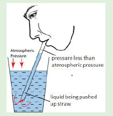
2. Compare and contrast the pressure from the straw and pressure
from atmosphere.
3. Explain the factors that can influence the distribution ofatmospheric pressure at a given surface.
i) Meaning of atmospheric pressure
Atmospheric pressure is the force per unit area that is exerted against the
Earth’s surface by the weight of air above it.
ii) Measurement and recording of atmospheric pressure
The barometer is the instrument used to measure atmospheric pressure. There
are two types of barometers: Mercury barometer and Aneroid barometer. The
line on the map joining places with the same atmospheric pressure is called
isobar.
iii) Factors influencing the distribution of atmospheric pressure
The following factors influence atmospheric pressure:
• Altitude: The pressure at the ground level is higher than that at the
top of high mountains. This is because air at the ground level has to
support the weight of the air above it.
• Temperature: When air is heated, it expands. When this happens,
the outward pressure of its molecules is spread over a large area.
This means the pressure of the air decreases. The pressure of the air
therefore rises when its temperature falls.
• Latitude: The earth is not a perfect sphere and therefore force of
gravity varies according to latitude. This is at maximum at the poles
and a minimum at the equator. Atmospheric pressure is therefore
lower at the equator and higher at the poles.
• Season of the year: Atmospheric pressure changes with seasons of
the year being high over the cold continental interiors in winter and
conversely low over the heated continents in summer.
• The nature of earth’s surface: During the day, land heats up morethan the water and hence air pressure is lower over land than the sea.
Application Activity 8.2
Observe carefully the table below showing rainfall and temperature dataof Weather Station K in country R.
Answer the following questions: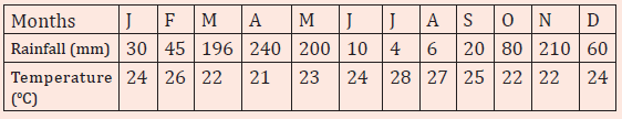
1. i) What is the driest month of the year?
ii) What is the wettest month of the year?
iii) Calculate the total annual rainfall.
iv) Calculate the mean annual temperature.
v) Draw the graph portraying the data in the above table.
2. Briefly explain the factors that influence weather and climate.
3. Walk around the school and observe the way the wind is blowing by
movement of tree branches. Then describe the direction in which thewind is blowing.
8.3. Factors that influence world climate
Activity 8.3
Explain how the following influence climate of any region:(a)Latitude; (b) Altitude; (c) Water bodies
The following are the main factors influencing world climates:
i) Latitude: The equatorial zone experiences high temperature and
precipitation, while they are low at the polar zone. This is due to the effect
of convergence of tropical trade winds that converges at equatorial
region. Their convergence causes the ascendance of air masses and the
formation clouds which generate much rainfall.
ii) Altitude: Temperature decreases with increasing altitudes from the
earth’s surface. Precipitation, called orographic precipitation, on the
other hand increases with the altitude.
iii) Presence or absence of water bodies: the temperature of regions near
lakes or seas are influenced by the proximity of these large water bodies.
When the continent is cool it can be warmed by the heat emanating from
water bodies.
iv) Vegetation: Vegetation influences precipitation and moderate
temperatures. Through transpiration, clouds form near the forests and
precipitation occurs.
v) Human activities: Pollution from industries affects the climate. Chemicals
and gases that are released into the atmosphere cause acid rain.
vi) Ocean currents: The warm ocean currents from tropical areas to cold
zones raise the temperature in these areas. For example, the Gulf Stream
increases the temperature of the coastal areas of North-Western Europe.
While Kuroshio warm currents raise the temperature of the coasts of Japan.
vii) Monsoons winds: These are seasonal winds which reverse their
direction at least twice a year. This results in the air blowing from the land
to the Ocean in winter and from Ocean (water) to the land in summer.
This situation makes the summer to be hot and wet and winter to be coldand dry in the affected areas.
Application Activity 8.3
Read the following context and give feedback to the questions that follow:
Generally, climate of any region or area is influenced by both physical
factors (Latitude, altitude, water bodies, vegetation, ocean currents
and aspect in relation to location) and human factors (pollution from
industries, Chemicals released into the atmosphere, cutting down of
forests /deforestation, over cultivation, overgrazing, land reclamation
and construction).Illustrate these geographical factors in Rwandan context.
8.4. Types of climate and their characteristics
Activity 8.4Observe the maps provided below and answer the questions that follow:
Identify the types of climate shown by the maps Q, P and X and identify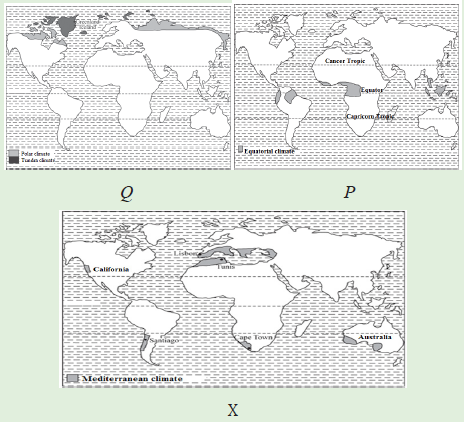
their characteristics
The classification of climatic zones is based on temperature and rainfall. There
are three world climatic zones. These are: Tropical, Temperate and Cold zones.
8.4.1. Tropical zones
i) Equatorial climate and characteristics of equatorial region
Equatorial climate is also called tropical wet climate or tropical rainforest
climate. It is found along the equator extending from 5° to 10° South and North
latitudes. Along the Eastern margin of continents, it spreads to 15° - 25° of
latitudes. This type of climate is found specifically in the amazon basin in South
America, the Congo basin in Africa, Malaysia, Indonesia in the south East Asia
and etc.
The following are the major characteristics of equatorial region:
• This climatic region is located within 5° to 10° south and north of the
Equator.
• The average monthly temperatures are over 18°c. However, many
places record average monthly temperatures of 24° to 27°c.
• The Equatorial regions lie in a belt where the winds are light. It is a
low-pressure belt.
• The annual range of temperature varies from 5°to 8°c.
• The annual average rainfall in the equatorial climate is nearly 2500
mm.
• There is a large amount of cloud.
• Conventional rainfall is received, and it is usually accompanied by
thunderstorms.
• High temperatures and heavy rainfall encourage growth of natural
vegetation. There are evergreen dense forests.Below is an example of Singapore weather station in x year:
(ii) Tropical marine climate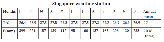
It is found on the East coasts of regions lying between 10° N and 25° N and
10° S and 25° S of the equator. These areas come under the influence of onshore
Trade Winds. Examples are East coast of Brazil, the Eastern coastlands of
Madagascar, Mexico, Nicaragua, Guatemala, Venezuela, the lowlands of Central
America, West Indies, the coast of Queensland (Australia) and the southern
islands of the Philippines.
Climatic characteristics of Tropical maritime/maritime climate
• The annual temperature range is about 8°c.
• Temperatures reach 29°c during the hot season while it is about 21°c
during the cold season,
• Annual rainfall varies from 1000 mm to 2000 mm.
• Rainfall received is both convection and orographic brought by onshore
Trade Winds.
• Humidity is high throughout the year.
• Sea breezes lessen the effects of the heat.
• Tropical maritime climate is good for tree growth. The lowlands havetall and evergreen trees.
(iii) Tropical continental climate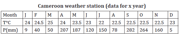
This climate occurs between 5° N and 15° N and 5° S and 15° S. It is in West,
East and Central Africa, South America, parts of the Deccan plateau (India) and
the areas to the north and east of the Australian Desert.
Climatic characteristics of Tropical continental climate
• Heavy convectional rainfall is mainly in the summer.
• Annual rainfall is about 765 mm.
• In some regions, the offshore winds are strong and hot. An example is
the Harmattan of West Africa.
• Humidity is high during the hot, wet season.
• Summers are hot (32° C) and winters are cool (21° C).
• The annual temperature range is about 11°C. The highest temperatures
occur just before the rainy season begins. This is in April in the northern
hemisphere and October in the southern hemisphere.
iv) Savannah climate (Tropical wet-and-dry climate)
This is located between 5° and 20° latitudes on either side of the Equator. It is
found in Latin America. These are the Llanos of the Orinoco Valley including
Colombia and Venezuela, the Guyana Highlands and the Campos of Brazil.
In Africa, it is found in the South of the Congo basin, the Southern part of
Democratic of Republic of Congo, Angola, Zambia, Mozambique, Tanzania,
Uganda, Botswana, South-Western Madagascar, Central Nigeria, Southern
Kenya, Togo, Ghana and Ivory Coast.
Climatic characteristics of Savannah Tropical climate
• High temperature of around 20°c.
• The annual range of temperature is greater than in the equatorial
regions. It is over 3° but not more than 8°c.
• Total annual average precipitation varies from 1000 mm to 1500 mm.
Much of the rain falls during the summer.
• The vegetation is grasslands with scattered trees and bushes.
(v) Tropical desert climate
Most of these deserts lie between 15° to 35° N and S of the equator. The hot
desert climate is found in the following deserts: Atacama (the coastal deserts
of Peru and Chile in South America), the Namib and Kalahari deserts of coastal
Angola and South West Africa, interior part of Botswana and South Africa, the
great Australian desert, the Sahara and the Arabian deserts, the Iranian desert,
the Thar desert of Pakistan and India, California (USA) and the deserts of
Northern Mexico.
Climatic characteristics of Tropical desert climate
• Hot deserts have the high temperatures throughout the year.
• They have cloudless skies and little or no humidity.
• The daily ranges of temperature vary between 22° to 28° C. In rare
cases, the diurnal range may be as high as 41.7° C.
• The annual average precipitation is less than 250 mm.
• Relative humidity is high.
• There is little plant cover.Below is an example of Khartoum (Sudan) weather station:
vi) Tropical Monsoon Climate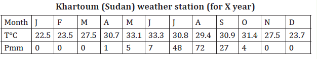
This is found in areas with seasonal land and sea winds. On-shore summer winds
blowing from over tropical warm Oceans bring about heavy precipitation. Offshore
winds from over the land make the weather dry during winter.
Monsoon climate is found in the coastal areas of Eastern and Southern Asia.
These places include India, Burma, Bangladesh, Indo-china, Southern China,
and Philippines, Taiwan, Japan and Korea.
In tropical Africa, it is found along the South-West coast of West Africa. These
areas include the coasts of Guinea, Sierra Leone, Liberia, and Ivory Coast.
Other areas are the Northeast coast of Latin America from the mouth of Orinoco
River in Eastern Venezuela through Guyana, Surinam and French Guyana to the
North-Eastern part of Brazil. The North coasts of Puerto Rico and the Dominican
Republic in the Caribbean Islands which have a mild monsoon climate.
Characteristics of Tropical monsoon climate
• High temperatures (32°c) in the hot season (summer) and low
temperatures (15°c) in the cold season (winter).
• High annual range of temperatures of about 17°c.
• Summers receive high rainfall of up to 2500 mm.
• The winters are dry.
• There is a reversal of winds. In one season they blow from sea to land
(onshore). These bring heavy rainfall. In the other season, they blowaway from the sea (offshore), such come along with little rain.
8.4.2. Temperate zone
i) Mediterranean Climate
Mediterranean climate is found between 30°and 40°N and S of the equator. This
is on the western sides of the continents. This climate is found in five regions
of the world:• North of the Mediterranean Sea from Portugal to Turkey and beyond• The central and Southern California coast in the United States of America.
in the Iranian Highlands, Morocco, Northern Algeria, and Tunisia, andNorth of Bengasi in Libya.
• Central Chile.
• The Cape Town area of South Africa, and
• Southern Western coasts of Australia.
Characteristics of Mediterranean climate
• The average temperature of the coldest month is between 4.4°C and
10°c. That of the hottest month is between 21° C and 27°c.
• The mean annual temperature ranges are between 11°and 17°c.
• The average annual precipitation is between 350 and 750 mm.
• There is rain in winter while the summers are dry.Below is an example of Algiers (Algeria) weather station:
ii) Temperate Maritime Climate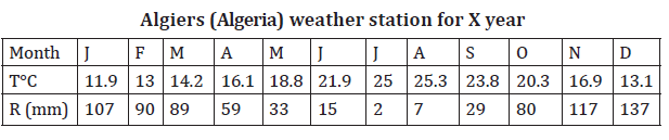
This type of climate is found between 40° and 65° N and S of the equator. These
are regions to the West of continents.
It is mainly found in Western Europe including Great Britain, North Western
France, Germany, Denmark, Holland, Belgium and Norway.
In North America, it is found along the West coast up to 60° N of the equator.
It borders the Sub-Arctic climate of Canada and Alaska. In Europe, it extends
along the west coast of Norway to 68° N.
In the Southern Hemisphere, it is found to the Southwest coast of Chile,
Southeast coast of Australia, the islands of Tasmania and New Zealand.Below is an example of Brest (France) weather station:
Characteristics of Temperate Maritime climate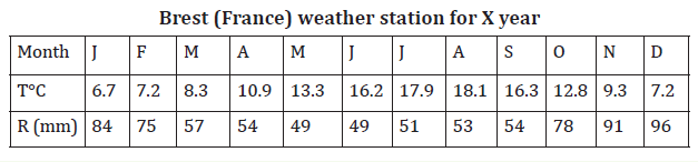
• Temperatures are influenced by the warm Ocean currents.
• This climate has cool summers and mild winters.
• The annual range of temperature is about 7° C.
• Average temperatures in summer are between 15° C and 18° C. Winter
temperatures range between 11° and 17° C.
• In Europe, the lowlands receive an average precipitation of 500 mm to
850 mm. On the windward side, it is between 2500 mm and 3750 mm.
iii) Continental Temperate climate
This type of climate occupies a large part of the United States of America. In
Europe, it is found in Romania and Bulgaria. It occupies the lower Danube Valley.
In Eastern Asia, it is found in North China bordering the yellow Sea, North and
South Korea, and Northern Honshu in Japan.
Characteristics of continental temperate climate
• Temperate continental climates are found on continents in the
Northern Hemisphere between 40o-70o
• Climate in these areas is controlled by the fact that they are not located
near Oceans where temperatures are moderate.
• Temperate continental climates are also called micro thermal climates,
because they are located away from the Oceans. These climatic zones
experience the extremes of temperatures.
• Summers are warm and can be very humid while winters are cold with
snowstorms and blustery winds.
• The annual average temperatures are around 100 C.
8.4.3. Cold zone
i) Polar and Tundra climate
The Tundra climate is found in the northern hemisphere beyond 60° N of the
equator. These are areas to the North of Asia and Canada. It also occurs on the
coast lands of Greenland. Polar climate is found in Greenland, interior of Iceland
and in the Antarctica.
Characteristics of Tundra climate
• The average annual rainfall is 250 mm.
• Precipitation is in the form of snow in winter and rainfall in summer.
• Humidity is low because of low temperatures.
• Winter temperatures are low. They range from - 29°c to 4°c. Summer
temperatures average about 10°c.
• Vegetation consists of mosses, lichens and dwarf trees and shrubs. It is
called tundra vegetation.
Characteristics of Polar climate
• Temperatures are always low. They are below 0°c, which leads to snow.
• Precipitation mainly occurs in summer. It averages between 100 mm
and 250 mm.
• Winters are associated with one continuous night. Summers are one
continuous day.
• Blizzards are common. These are snowstorms with high winds.
Visibility is low.
• There is hardly any vegetation. This is because of snow and ice cover.Below is an example of ours weather station for X year:
ii) Mountain climate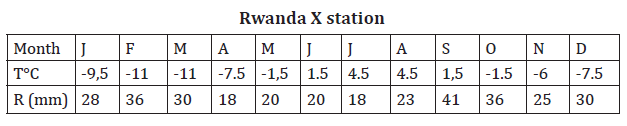
This type of climate is found in the mountain ranges of the world. These include
Mt. Kenya, the Ethiopian Highlands and the Alpine ranges of Europe. Others are
the North Western part of Rwanda, especially over volcanic region, the Andes
of South America and the Rockies of North America.
Characteristics of Mountain climate
• High rainfall on the windward slopes. It is less on the leeward slopes.
• Orographic rainfall is received.
• Pressure and temperature decrease with altitude.
• But if the mountains are high enough, there is a height at which
maximum precipitation occurs and above which it decreases.
• It is also characterized by strong local winds (mountain and valleybreezes).
Application Activity 8.4
a) Draw a world sketch map and on it mark and label the world climatic zones.
b) Describe the characteristics of each climatic zone shown on thatworld sketched map.
8.5. Influence of climate on human activities
Activity 8.5
“People in North Western part of Rwanda grow Irish potatoes, while
people in Southern Rwanda grow cassava and those of Eastern Rwanda
grow bananas. Again, in some regions of Rwanda tea is grown as a cash
crop while other does not”.
Hence explain how those crops grown are influenced by climatic conditions
in each part.
Climate influences the distribution of population. This is because of temperature
conditions, amount of precipitation and length of crop growing season.
The relationship between climate and human activities is summarized below:
i) Human activities in equatorial regions: Heavy rainfall and high
temperatures support growth of forests. The main human activities are
lumbering and agriculture. Crops such as coffee do well in this type of
climate.
ii) Human activities in savanna climate: This type of climate is good for
agriculture and dairy farming. There is enough grass for the animals.
Growing of vegetables is done in this type of climate.
iii) Human activities in desert climate: The high temperatures and low
rainfall are not supportive for agriculture. Animal keeping is also not well
developed only camels, goats and sheep are kept in such type of climate.
Furthermore, it is only around the oases that some farming is done.
iv) Human activities in temperate climate: This type of climate is suitable
for agriculture and livestock keeping. Most developed countries are in
this type of climate. These zones have high population.
v) Human activities in polar climate: The main activities in this zone arethe fishing and hunting. Few people are found here.
Application Activity 8.5
“Most of entrepreneurs look for climatologists and meteorologists toadvise them when locating their firms”, Discuss the statement.
Skills lab
Good and favourable climate is a key factor to the development of all human
activities. With the help of your local leaders organise a seminar on how
conservation of the natural environment can lead to a good climate and hence
leading to the economic growth of the country.
End unit Assessment
1. With aid of diagram describe the structure of atmosphere.
2. To what extent atmosphere plays a considerable role in regulating/
control negative effects of solar radiation?
3. Visit a weather station near your school to identify instruments
used to measure and record weather conditions.
4. (a) Briefly describe the characteristics of Rwandan climate,
(b) Explain the factors influencing the climate of Rwanda.
5. “Human activities depend upon climate and weather conditions ofan area” with relevant examples in Africa, support this statement.