General
- Geograpy SSE Y2 SB File Uploaded 2/11/21, 16:08
- Geograpy SSE Y2 TG File Uploaded 2/11/21, 16:07
UNIT 6:INTERNAL LANDFORM PROCESSES
Key unit Competence: The student-teachers should be able to examine
the internal processes responsible for theevolution of different relief landforms.
Introductory activity
In reference to the diagrams above showing the internal landforms’ processes;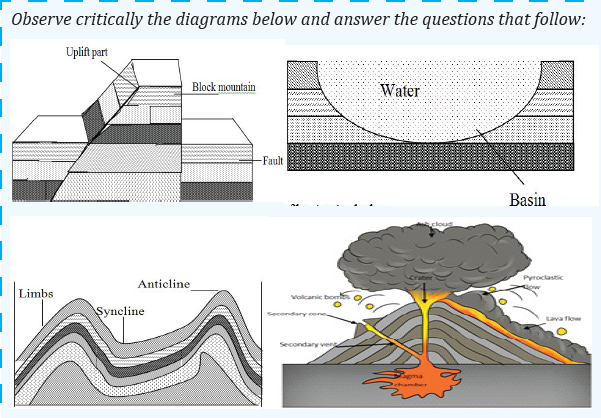
answer the following questions:
a) Identify the internal processes associated with each diagram illustrated
above.
b) Describe how the internal processes lead to the formation of various
relief features.
c) Identify the effects of the features resulting from internal processes onhuman activities.
6.1. Faulting
6.1.1. Faulted landforms and forming processes
Activity 6.1
Using textbooks, internet, and other resources of geographical information
research on:
1. Meaning of the faulting and fault
2. The processes responsible for the formation of different faulted
landforms
(i) Meaning of faulting and fault
• Faulting is the process through which the rocks of the earth’s crust
crack or fracture due to tectonic forces as accompanied by displacement
of blocks. The direct effects of faulting include the formation of rift
valley, block mountains, fault scarps,
• A fault is a fracture in the crustal rocks where the rocks are displaced
along a plane called a fault plane. A fault is also considered as a rupture
or fracture of rock strata due to strain, in which displacement isobservable.
ii) Forces causing faulting
Faulting is the fracturing of the crustal rocks due to the influence of endogenic
forces or processes. Endogenic forces are responsible for various types of vertical
irregularities that give birth to numerous relief features including mountains,
plateaus, plains, lakes, faults and folds. The endogenic forces include faulting,
folding, warping, vulcanicity and earthquake.
iii) Main parts of a fault
The process of faulting is caused by tensional and compressional forces. When
these forces act on crustal rocks of the earth’s crust, they develop stress in them
and break along the zone of maximum tension. The rocks are then removed
from their original position either upwards, downwards or horizontally.
When a rock is displaced upward it is called up throw, and the downwarddisplacement is called down throw.
The main parts of a fault are (1) the fault plane, (2) the fault trace, (3) the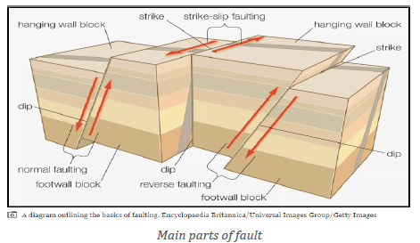
hanging wall, and (4) the footwall. The fault plane is where the action is taking
place. It is a flat surface that may be vertical or sloping. The line it makes on
the earth›s surface is the fault trace. Where the fault plane is sloping, as with
normal and reverse faults, the upper side is the hanging wall and the lower side
is the footwall. A strike is the direction of the fault trace on the earth›s surface.The dip is the measurement of how steeply the fault plane slopes.
Application Activity 6.1
Basing on the knowledge and skills acquired from the above lesson,describe the area where the faulting process occurred.
6.1.2. Types of faults
Activity 6.2
Observe the diagrams below and use other geographical resources toanswer the questions that follow:
Faulting results into numerous types of faults briefly described in the following: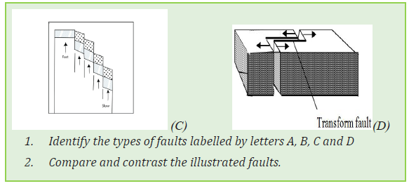
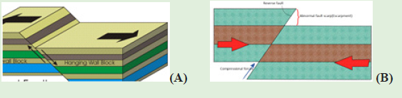
i) Normal faults/consequent fault lines are formed due to the tensional
forces that lead to opposite displacement of the rock blocks. The steepscarp resulting from normal faults is called fault-scarp or fault-line scarp.
ii) Reverse faults/ obsequent fault lines are formed due to compression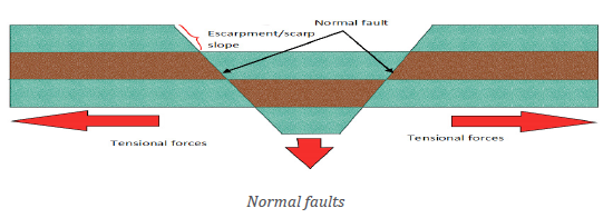
forces that lead to the movement of the fracture rock blocks towardseach other. The fault plane in a reverse fault is usually inclined.
iii) Lateral or strike-slip faults are formed when the rock blocks are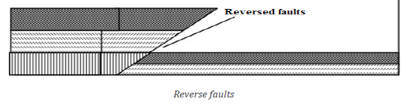
displaced horizontally along the fault plane. They are called left-lateral or
sinistral faults when the displacement of the rock blocks occurs to the lefton the other side of the fault, they are called right-lateral or dextral faults.
iv) Step faults are formed when a series of parallel faults occurring in an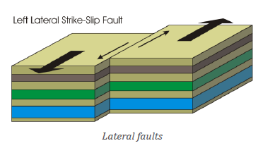
area in such a way that the slope of the entire fault planes of the faults arein the same direction.
v) A thrust fault refers to a reverse fault in which the dip of the fault plane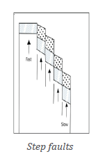
is at a small angle to the horizontal and it is caused by strong crustalcompressional forces.
Application Activity 6.2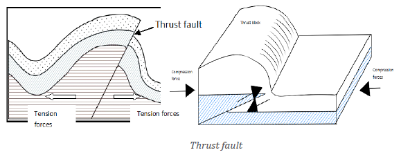
Basing on the knowledge and skills acquired from the above lesson,describe the area where the faulting process has occurred in Rwanda.
6.1.3. Influence of faulting on landscape and drainage
Activity 6.3
Kwigira and Mahoro are students from GS Terambere. They visited Lake
Kivu and its surrounding area in western part of Rwanda. Back to school
they were told to make description of the area visited. In the description
they included: Lake Kivu and other different relief features around. They
said that their teacher called Bumwe who accompanied them explained
how Lake Kivu was formed. He said that Lake Kivu was formed in the
same way as Lake Tanganyika, Eduard, George, Manyara and Turkana
in East Africa. Furthermore, the teacher told them that there are other
landforms which resulted from faulting in Africa and the World. Based on
this story to answer the following questions:1. Describe the impact of faulting on landscape of the area visited by
Kwigira and Mahoro.
2. Examine other landforms produced because of faulting not
mentioned in the passage above.
3. Assess the impact of faulting on drainage system.
i. Influence of faulting on landscape
There are several landforms produced by faulting. They include rift valleys,
fault scarp, escarpments, block or Horst Mountains, fault guided valleys, titled
block/landscape and Grabens which host rift valley lakes.
Rift Valley
Rift valley is a trough or hollow/depression (Graben) which may result from
both tensional and compressional forces. It is formed when two faults aredeveloped parallel to each other.
Various theories have been put forward to explain the formation of a rift valley.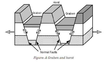
They include tensional theory, compressional theory and differential up-lift
theory. They description is briefly described in the following
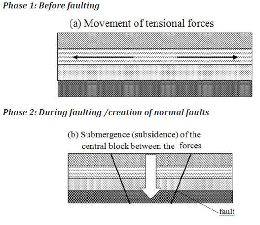
Formation of the rift valley by tensional forces (Tensional theory by J. W.Gregory)
Rift valley is formed when tensional forces move away from each other. These
tensional forces produce faults and the block (part of the crustal block) between
two parallel faults subsides to form a rift valley, while the outer blocks remainstanding to form escarpments.
Formation of the rift valley by compressional forces (Compressional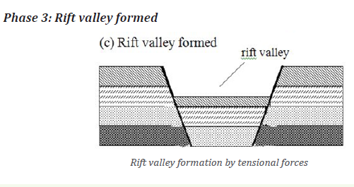
theory by E.J. Wayland)
Rift valley is formed when horizontal forces act towards each other. These
forces push the crustal rocks or layers towards the center from all sides.
These forces of compression produce two parallel faults and the pieces of land
on either side are lifted above the general level of the ground to form a rift
valley. How the affected rocks respond to compressional forces depends on
how brittle (breakable) the rocks are and the speed with which the forces are
applied. Brittle (rigid) rocks will break down and result in formation of faults.
This process is known as faulting. Folding, which is a bending or wrinkling
of rock layers, occurs when compressional forces are applied to rocks that are
ductile (bendable), as opposed to brittle.

Theory of differential uplift (by Dixey and Troup)
Rift valley is formed when normal faulting produces several normal fault lines
followed by gradual up lift of the faulted area with several step faults. Typical
example is Kedong in the part of Nairobi.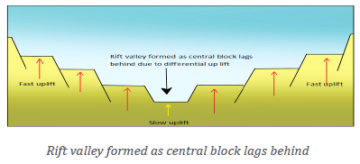
Theory of crustal separation/Plate tectonics theory
This is formed in manner of sea-floor spreading or tectonic movement, where
convectional currents within the mantle rise vertically and then divert from each
other horizontally. This results to the dragging of oceanic or continental plates.
Such results into breaking of crustal layers that are dragged apart together
with continental rafts. As movement continued the central block was forced to
subside. For example, the separation of Arabian block from East African block
show the closeness of continental drifting that seems to be taking place in East
African Rift valley.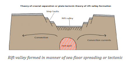
ii. Influence of faulting on drainage
The following is the influence of faulting on drainage system:
• There is development of specific types of drainage patterns in a
given area. These include rectangular, parallel and trellised drainage
patterns.
• Formation of fault guided valleys. In this case, rivers flow following
the layout of the fault guided valley. A good example is River Rusizi in
western Rwanda.
• River reversal (change of direction). Example is River Katonga and
Kafu in western Uganda that were joining the Congo River basin and
reversed towards Victoria basin.
• Rift valley lakes are formed when graben or rift valleys are filled by
water. Typical examples include: Lake Kivu, Eduard, Albert, George,
Tanganyika in western arm/branch of East African rift valley, Turkana,
Manyara, Nyasa, Magadi in Eastern arm/branch of East African rift valley.
• Waterfalls in faulted areas such as Rusizi, Mururu in Rwanda and
Mubuku water falls in South Western part of Uganda.
• Rising of the underground water table along fault planes. Typical
examples are Mwiyanike, Nyamyumba in Rwanda.
Application Activity 6.3
Explain the influence of faulting on landscape and drainage system in the
context of Rwanda.
6.2. Folding and warping
Activity 6.4
Read the passage below and provide answers to the question that follow:
The relief of Rwanda is characterized by six topograhic units that include
Bugarama plain and Lake Kivu Banks, Congo-Nile crest, Central plateaus,
Eastern low lands, Buberuka region and the Volcanic region. Some of these
topographic units were formed through faulting process as it was explained
in the previous lesson. Those topographic units formed as result of faulting
include Bugarama plain and Kivu banks. On the other hand volcanicity
has been responsible for formation of volcanic relief in Northern, while the
Eastern lowlands resulted from warping. Some landforms of Rwanda were
formed through folding process.
1. Refer to the above presented passage to answer the following questions:
a) Explain the folding processes
b) Differentiate the folding processes from other internal processes in the passage.
2. Suggest the impact of folding process on any landscape you have
observed.
6.2.1. Folding and its process
(i) Meaning of folding and folds
Folding is a process by which crustal rocks bend due to compression forces. This
results from horizontal movement caused by the endogenic forces originating
deep within the earth.
Folds are the wave-like bends resulting from folding processes. The up-folded
rock strata in arch-like forms are called anticlines while the down folded
structure forming trough-like feature is called syncline. The sides of a fold are
called limbs of the fold.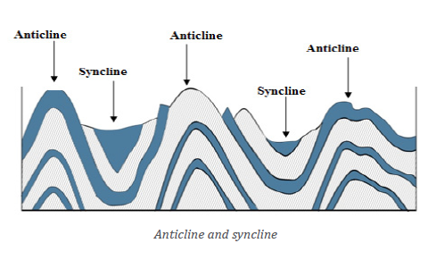
(ii) Processes of folding
The processes of folding are mainly engineered by the presence of compressional
forces that push intensely the crustal layers towards a common centre. It occurs
in areas with soft and young rocks and instead of fracturing due to internal
forces or convectional currents that lead to formation of compressional forces
the crustal layers start to bend.
(iii) Types of folds
Based on the inclination of the limbs, folds are divided into the following
categories:
a) Symmetrical folds are formed when compressional forces work
regularly but with moderate equal intensity. Symmetrical folds are very rare.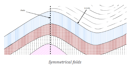
b) Anticlinal fold: This is a fold that has the convex appearance and has its
oldest beds at its core.
c) A syncline fold: This is a fold with younger layers closer to the center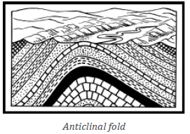
of the folded structure. Synclines are typically a downward fold, termed
as syncline (i.e. a trough) but synclines that point upwards can be foundwhen strata have been overturned and folded.
d) Asymmetrical folds: These are formed when there the compressional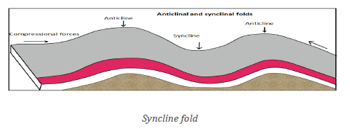
forces acting upon the crustal young layers are unequal. One side isintensely pushed while the other is moderately compressed.
e) Over fold: This is a type of fold formed where the compressional forces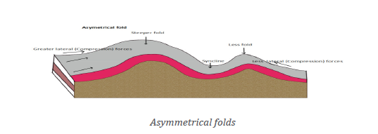
push with great intensity one limb to the extent of the land folding so muchthat the anticlinal part or crest is pushed over the would-be syncline.
(iv) Influence of folding on drainage and landscape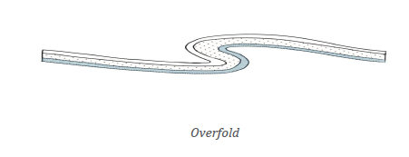
a) Influence of folding on drainage
The following are ways through which folding has influenced drainage:
• Formation of various water falls in Rwanda and elsewhere in the
World. Some of the waterfalls are located on the upward folded areas.
A good example is Rusumo water fall.
• Fold Mountains are good catchment areas. A typical example in Rwanda
is in Gicumbi District.
b) Impact of folding on landscape
There are various landforms resulting from folding. These include the following:
i) Rolling plains: These types of landforms result from down warping
movement caused by the folding processes. They have gently sloping
anticlines with very wide synclines.
ii) Ridge and valley landscape: The strong compressional forces create
a series of asymmetrical folds. The anticlines form the uplands (ridges)
while the synclines form the valleys.
iii) Fold Mountains: The mountains rise to different heights depending onthe velocity and intensity of compressional forces.
6.2.2. Warping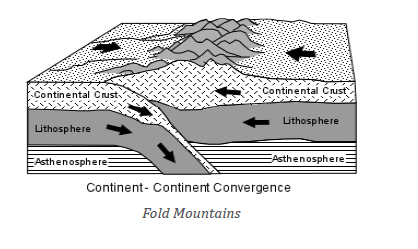
i) Meaning of warping
Warping is the downward movement of crustal rocks caused by sinking
convectional currents within the interior part of the earth. This results into
formation of a saucer-shaped basin. A typical example where warping took
place in East Africa is Lake Victoria basin.
ii) Types of warping
There are two types of warping:
a) Down warping: This is formed when the sinking convectional currents
drag down wards the lower part of the crust. Therefore, the crustal layers
bend inwardly to form basins. This created East African major basins i.e.
the depressions occupied by Lake Victoria, lake Kyoga in Uganda and Lake
Muhazi in Rwanda are good examples.
b) Up warping: During the down warping the outer parts of the crustal layers
tend to move upwards. This is commonly caused by isostatic movement
associated with upward movement. This produced up land regions likeEast African plateaus and other uplands elsewhere in the world.
c) Broad warping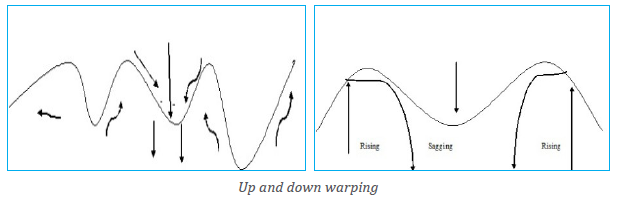
When the process of up warping and down warping affects larger areas, the
resultant mechanism is called broad warping.
iii) Causes of warping
Warping is mainly caused by convectional currents that result into lateral
compressional forces of low intensity. Typical examples are common in East
Africa where few areas escaped the down warping and up warping process.
The resultant impact on the landscape of Africa is evidenced by: African Basins,
crustal warped lakes, extensive swamps around the lakes, extensive plateaus,
reversal of some rivers, etc.
(iv) Landforms associated with warping
The process of warping led to formation of numerous landforms which include
the following:
a) Plateau: It is a large, extensive uplifted part of the earth’s crust
which is almost flat at the top. The top of the plateau is mostly plain.
Examples include: Eastern plateaus of Rwanda, Guinea highlands,
Jos plateau (Nigeria), Ahaggar (north centre of Sahara), etc.
b) Basin: It is a large and extensive depression on the earth’s surface.
Most basins are formed due to vertical downward movement of theearth’s crust.
Examples of basins include: Congo basin, Chad basin, and Amazon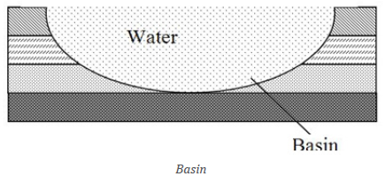
basin. When a basin is filled by water; it forms basin lakes like Lake
Muhazi and Mugesera in Rwanda, Lake Victoria, etc.
c) Plains: These are flat areas that are in lowland areas. Typical
examples are generally in coastal regions that were greatly affectedby warping process.
(v) Influence of warping on drainage
The following is the influence of warping on drainage:
• Some rivers change their courses due to warping in a given area. A
good example is the case of hydrography of East Africa where some
rivers changed direction and other filled depressions to form lakes.
• Formation of many lakes in East Africa. Good examples include: Lake
Victoria and Lake Kyoga in Uganda, Lake Muhazi and Mugesera in
Rwanda.
• Presence of waterfalls which are located on the upward warped areas.
• The drainage of Rwanda flows from west to east from the up warpedfeatures of Rwanda.
Application Activity 6.4
1. “Some parts of East Africa have been affected by up warping and
down warping.” With relevant examples support this statement.
2. Draw a sketch map of Rwanda, on it label and name the majorlandforms which resulted from warping.
6. 3. Vulcanicity and earthquakes
6.3.1. Vulcanicity
(i) Processes of vulcanicity and volcanicity and associated materialsActivity 6.5
1. Identify and explain the process illustrated in the above figure.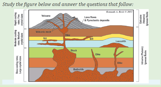
2. Suggest the materials which are ejected out associated with the process
identified in (1) above.
Terms used in vulcanicity
The following are the key terms used in vulcanicity studies:
• Vulcanicity refers to the processes from which the molten materials
are either ejected on the surface of the earth or remain in the earth’s crust.
• Volcanicity refers to the process by which lava through volcanic
eruption is ejected to the earth’s crust.
• A volcano is a mountain that opens downward to a reservoir of molten
rock below the surface of the earth.
(ii) Materials of vulcanicity
Volcanic materials of various types are ejected through the volcanic pipe known
as a vent. This is situated in the part of fault line that assisted the escape of
magma. Volcanic materials include the following:
• Vapour and gases: Stream and vapour include phreatic vapour and
magmatic vapour. Volcanic gases include carbon dioxide, nitrogen
oxides, sulphur dioxide, hydrogen and carbon monoxide.
• Magma and lava: Molten rock materials are called magma when they
are still below the earth’s surface. When they reach the earth’s surface,
they are known as lava. Lava and magma are grouped into two classes.
These include the following:
i. Based on silica percentage; lava and magma are divided into two
groups: acidic magma (high percentage of silica) and basic lava
(low percentage of silica).
ii. Based on light and dark coloured minerals; lava and magma are
also classified into Felsic and Mafic lava.
iii. Based on size of pyroclastic materials: These are grouped into four
kinds:
─ Volcanic dust (finest particles)
─ Volcanic ash (2 mm in size)
─ Lapilli (of the size of peas), and─ Volcanic bombs (6 cm or more in size).
Application Activity 6.5
1. Describe the main materials derived from vulcanicity.2. Name and locate the volcanoes available in Rwanda.
(iii) Intrusive and extrusive features
Activity 6.6
Critically observe the photograph shown below and use it to find answersto the questions that follow:
Basing on your observation of the above photograph and the previous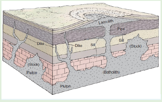
lessons on relief features of Rwanda studied in year one, describe the
landforms of volcanic region of Rwanda.
Magma found inside the crust may sometimes reach the surface of the crust
through fracture, fissures and consolidate from there. In this case the features
formed are extrusive features. But when magma fails to reach the earth’s
surface and consolidate inside the crust before reaching the surface; thefeatures formed will be called intrusive features.
i. Extrusive volcanic features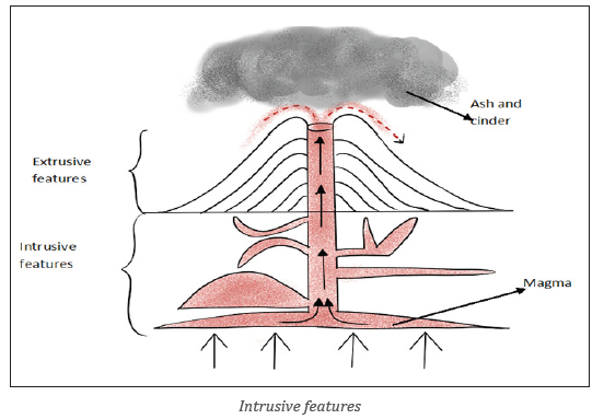
These features include the following:
a) Volcano: This is a mountain that opens downward to a reservoir of
molten rock below the surface of the earth. Unlike most mountains which
are pushed up from below, volcanoes are formed when molten rock
escapes to the earth›s surface. This solidifies to form highland known as
volcanoes.
b) Acidic lava cone: This refers to a cone made of viscous lava normally
that is ejected out of the earth’s crust and solidifying faster as soon as it
reaches the Earth’s surface. It always cools faster than basic lava becauseit is viscous in nature.
c) Basic lava cone: This is a cone of basic fluid/lava spread over a long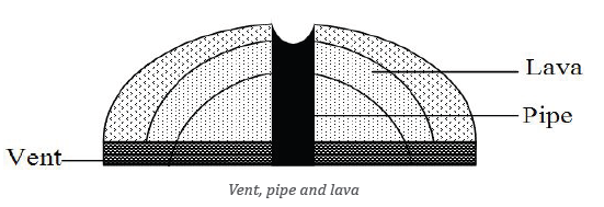
distance. Basic lava cone is characterized by gentle slope. Basic lava cone
is also known as shield or basalt volcanoes. Typical examples includeNyamuragira in DRC and Muhabura volcanoes in Rwanda.
d) Crater: This is a volcanic depression on top of the volcano. When a crater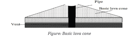
is filled by water, it forms Crater Lake. Examples of crater lakes in Rwandaare found on Kalisimbi, Muhabura and Bisoke volcanoes.
e) A caldera: This is a wide depression that forms on top of a volcanic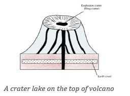
mountain due to explosive eruption or secondary eruption. When a
caldera is filled with water, a Caldera Lake is formed. Typical example of
dry caldera is Ngorongoro Caldera in Tanzania.
f) Ash and cinder cone: These are formed when lava is ejected into the air
violently, breaks into small particles known as Ash and cinder. These fall
back and pile up to form alternating layers of ash and cinder. These haveslopes that are importantly concave and asymmetrical in nature.
g) Volcanic plateaus: These are formed when there are various fissures or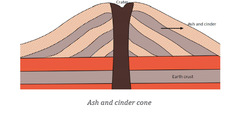
vents and basic lava flows out spreading to a wide area. This results into
the formation of a flat-topped highland known as volcanic plateau. Typical
examples of lava plateaus are found in Musanze, Nyabihu, Rubavu, Burera
(North Western part of Rwanda), Ethiopian highlands, Deccan plateau in
India and Bui plateau in Nigeria, Shirasu-Daichi in Japan and the NorthIsland Volcanic plateau in New Zealand.
h) Volcanic plug: This is also called a volcanic neck or lava neck, is a volcanic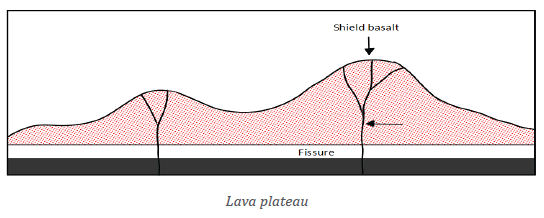
feature created when magma solidifies within a vent and later the softlayers of rocks surrounding it are eroded away.
(ii) Intrusive vulcanic features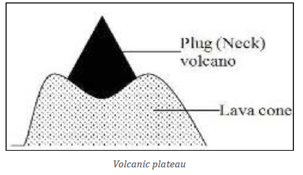
This is a type of vulcanicity where magma does not reach the earth’s surface
but cools and solidifies within the crustal rocks.They include the following, Lava flow, laccolith, Volcano, Dyke, Lapolith, sill, etc.
a) Batholith: This refers to large dome-shaped intrusion of magma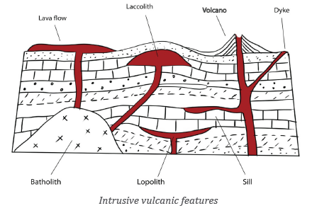
extending to great depth within the earth’s crust. Batholiths are formed
deep below the surface when large masses of magma cool and solidify.These may later be exposed because of erosion to form in inselbergs.
i) Laccolith: It is a dome-shaped intrusion of magma formed when the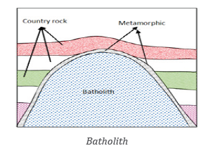
magma cools and solidifies in anticline bedding plane.
ii) Phacolith: This islens-shaped mass of igneous rock formed when magma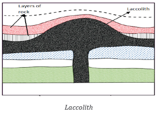
cools and solidifies at anticline and syncline in folded rocks. Phacolith ismuch shallower.
iii) Lapolith: It is a large saucer-shaped intrusion formed when magma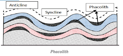
(molten rocks) cools and solidifies in a syncline bedding plane. Lapolithsform shallow basins along the rock bedding plane.
iv) Sills are horizontal intrusions of magma which have solidified along the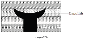
lines of bedding planes.
v) Dykes: These are vertical intrusions formed when magma solidifies in a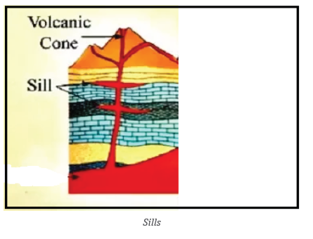
vertical manner or within the vent and subsidiary vents.They cut across
the bedding planes of the crustal rocks into which they have been intruded.
Dykes often occur in groups where they are known as dyke swarms.
Application Activity 6.6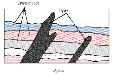
With the help of diagrams, differentiate intrusive and extrusive volcanic
landforms.
i. Types of volcanoes and their characteristics
Activity 6.7
In the previous lesson you learnt that vulcanicity leads to formation of
various landforms including volcanoes.
a) Describe volcanoes according to their period of activity.
b) Make a classification of the volcanoes according to their nature of
volcanic eruptions.
(a) Classification based on periodicity/activity of eruptions
The following are types of volcanoes based on periodicity or activity of
eruptions:
• Active volcanoes: These are volcanoes which constantly eject volcanic
lavas, gases, ashes and fragmental materials. These are erupted very
recently or are engaged in eruption. Examples are Nyiragongo and
Nyamuragira in DRC, Ol Doinyo in Tanzania, Lengai and Etna, Stromboli
(in Mediterranean Sea).
• Dormant volcanoes: These are volcanoes which have taken long
without erupting but still show signs of eruption. That is, theyare
quiet after their eruption for sometime. However, they suddenly erupt
violently and cause huge damage to human, animal and plant life
around them. An example is Muhabura, Karisimbi, Gahinga andBisoke
in Rwanda, Vesuvious near Naples in Italy.
• Extinct volcanoes: These are volcanoes that have taken a long time
without erupting and show no signs of erupting in future. A good
example is Mount Sabyinyo in Rwanda.
(b) Classification of volcanoes basing on the nature of eruptions
Based on the nature of eruptions volcanoes are classified into the following:
i) Explosive volcanoes: These are volcanic eruptions whereby the magma
is violently ejected out of the Earth’s crust through a central pipe (vent).
Explosive type of volcanoes are classified into the following:
• Hawain type of volcanoes: Such volcanoes erupt quietly due to less
viscous lava and non-violent gas. A good example is Nyiragongo of DRC,Mihara in Japan, Etna of Italy, Kilauea of the southern Hawaii island.
• Strombolian type: Such volcanoes erupt with moderate intensity.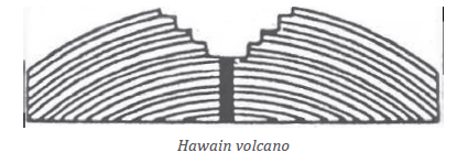
Besides lava, other volcanic materials like pumice, scoria and bombsare also ejected into the sky. e.g: Stromboli in Italy.
• Vulcanian type of volcanoes: Such volcanoes erupt with great force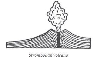
and intensity. The lava is so viscous and pasty that quickly solidifies
and hardens. E.g:Lipari in the Mediterranean Sea, Sakurajima in Japan etc.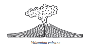
• Peleean type of volcanoes: They are the most violent and explosive
types of volcanoes. The ejected lava is extremely viscous (a large amount
of gas, dust, ash,and lava fragments are blown out of the volcano crater.e.g: Pellee Volcano of Martinique Island in the Caribbean Sea.
• Visuvious type of volcanoes: There is a violent expulsion of magma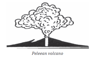
due to enormous volume of explosive gases. A good example is thePlini volcano in Italy.
ii) Fissure eruption type or quit eruption type: These occur along fracture,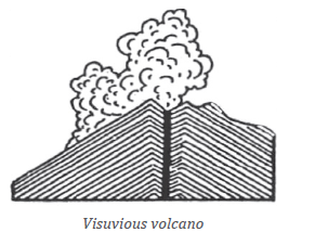
fault and fissure and there is slow upwelling of magma from below and
the resultant lavas spread over the ground surface. An example is Lakifissure eruption in Iceland.
Application Activity 6.7
With specific examples from East Africa,
a) Identify and describe the extrusive volcanic landforms.b) Categorize the volcanoes according to their period of activity.
ii. Influence of volcanicity
Activity 6.8
Observe the photograph of Bisoke crater provided below and answer thequestions that follow:
1. How did the volcanicity influence the formation of the mentioned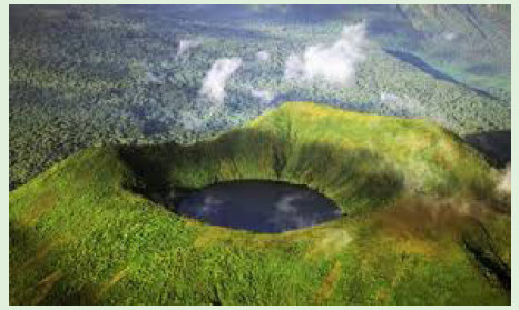
drainage feature?
2. Using your own experience, textbooks and internet, research on
the impact of volcanicity to the social economic development of a country.3. Locate the volcanic regions on the east Africa map.
In this section, we highlight some of impacts produced by volcanicity on
drainage systems, and humans, and we briefly describe the distribution of
volcanoes in the world.
(a) Influence of volcanicity on drainage
The volcanicity influences the drainage system in a given area in different waysas follows:
• Some seasonal rivers originate from the crater lakes and flow down
slope. The good example includes Susa River in Rwanda.
• Crater or caldera of volcanoes may be filled with water to form lakes.
Good examples in Rwanda are the lakes located on Bisoke, Muhaburaand Kalisimbi.
• Some rivers may change their courses due to volcanicity. For example,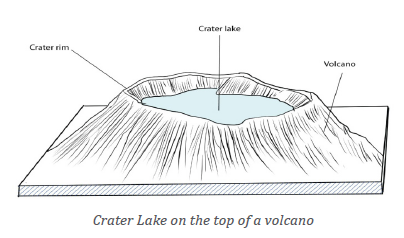
before the Rwandan volcanoes came into existence, Nyabarongo River
was flowing northward and then when volcanoes came in place, the
river changed its course which is southward.
• It leads to formation of lava dammed lakes. E.g. Burera and Ruhondo.
(b) Impact of volcanicity to the human
Volcanicity has both negative and positive impacts to human life, as briefly
described in the following paragraphs:
Positive impacts
The following are some examples of positive impacts of volcanicity:
• Volcanicity is associated with rich (fertile) volcanic soils that stimulate
agriculture;
• It leads to production of geothermal heat and geothermal energy;
• It stimulates mining of metal ore deposits (including gold, silver,
copper, tin, iron, lead, wolfram and zinc);
• Volcanicity is associated with the formation of crater and lava dammed
lakes that stimulate fishing and water transport. A typical example is
in Burera and Ruhondo lakes in Northern Rwanda;
• Industrial materials like building stone, pumice and clay are provided
by volcanic features;
• Volcanicity leads to formation of waterfalls that facilitate the generation
of electricity (HEP). A good example is at Ntaruka and Mukungwa
Hydro-power plants in Northern Rwanda.
• Volcanoes play a great role in modification of climate which supports
various human activities such as agriculture.
The hot springs are used for medicinal purposes, for example therapeutic water.
Negative impacts
The following are some examples of negative impacts of volcanicity:
• Volcanic eruptions cause heavy damage to human lives and property
through outpouring of lava, fallout of volcanic materials; speeding lava
flows.
• Too much volcanic materials also lead to diversion and blocking of
drainage systems and floods.
• The poisonous gases produced during the eruptions cause acid rain.
• Sometimes volcanic eruptions are followed by heavy rainfall. The heavy
rain mixes with falling volcanic dusts and gases to cause mudflows or lahar;
• Volcanic eruptions may generate tsunamis and seismic waves causingdeath to human beings.
(c) World distribution of volcanoes
There are three major belts or zones of volcanoes in the world. These are:
• Circum-Pacific belt: volcanic zones of the convergent oceanic plate
margins, including the volcanoes of the Eastern and Western coastal
areas of the Pacific Ocean. This includes island arcs and festoons off
the East coast of Asia and of the volcanic islands scattered over the
Pacific Ocean. This volcanic belt is also called “The fire girdle of the
Pacific or the Fire ring of the Pacific”.
• Mid-continental belt, also known as ‘the volcanic zones of convergent
continental plate margins’. This belt includes the volcanoes of Alpine
mountain chains and the Mediterranean Sea, and the volcanoes of the
faulted zone of Eastern Africa.
• Mid-Atlantic belt: This includes the volcanoes along the Mid-Atlantic
ridge which represents the splitting zone of plates. In other words,
two plates diverge in opposite directions from the mid-oceanic ridge.
Thus, volcanoes of fissure eruption type occur along the constructiveor divergent plate margins.
Application Activity 6.8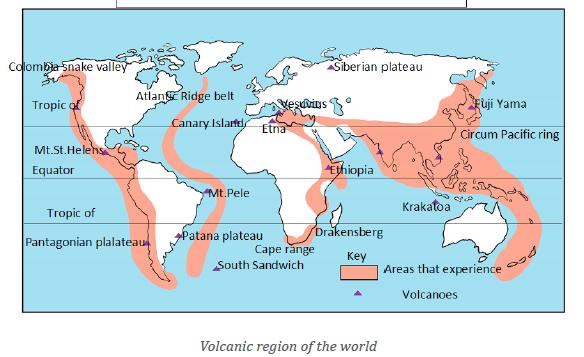
1. Examine the significance of volcanicity to the economic development
of the areas found in volcanic regions.
2. Assess the role played by volcanicity in the development of the
following economic activities in Rwanda:
a) Tourism industry
b) Agriculture
c) Power and energy
3. Locate and describe the major volcanoes of the world on world sketch map.
6.3.2. Earthquake
i. Meaning and causes of earthquakes
Activity 6.9
Read the passage about earthquakes occurrence and provide
answers to the questions that follow.
Earthquakes occur when masses of rock in Earth’s crust slip and slide
against one another. This kind of movement is most common along a fault,
a break in a body of crustal rocks that can extend for kilometers or even
hundreds of kilometers. When pieces of crustal rock suddenly slip and
move, they release enormous amounts of energy, which then propagates
through the crust as seismic waves.
At the Earth’s surface, these waves cause the ground to shake and vibrate,
sometimes violently.
Geologists classify seismic waves into two broad categories: body and
surface waves.
Body waves, which include Primary and Secondary waves, travel through
the Earth’s interior.
Primary waves resemble sound waves which mean they compress and
expand material as they pass. Secondary waves resemble water waves
which mean they move material up and down. Primary waves travel
through both solids and liquids, while Secondary waves only travel
through solids.
1. Identify the internal process explained in the above passage
2. Explain how that process occurs.
3. Conduct a research and find the meaning of the following
terminologies:
i. Hypocentre
ii. Epicentre
iii. Focusiv. Tremor
a) Meaning of earthquake and associated terminologies
An earthquake is a sudden tremble or shaking of the ground caused by abrupt
release of energy from crustal rocks; a motion of the ground surface, ranging
from a faint tremor to a wild motion capable of shaking buildings and causinggaping fissures in the ground.
• Focus or hypocentre: It is the place of origin of the earthquake and is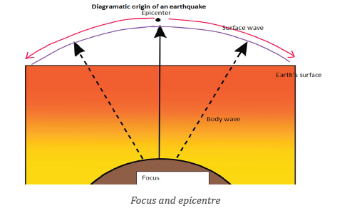
always hidden inside the earth. It is also considered as the place of the
occurrence of earthquake.
• Epicentre: It is a place on the ground surface which is perpendicular
to the focus. That place is the first to experience seismic event.
• Magnitude: It is a measure of the amount of energy released during
an earthquake.
• Tremors or temblor is the perceptible shaking of the surface of the
Earth, resulting from the sudden release of energy in the earth’s crust
that creates seismic waves.
b) Causes of earthquakes
Earthquakes are caused by both natural and human factors as follows:
Natural causes of earthquakes
Natural causes of Earthquakes are associated with endogenic forces resulting
from convectional currents.
• Volcanic eruptions of explosive and fissure types. Generally, volcanic
earthquakes are confined to volcanic areas.
• Dislocation of crustal rock blocks during faulting. Such earthquakes
are severe and disastrous.
• Disturbance in the isostatic balance at regional level due to imbalance
in geological processes. Generally, earthquakes occurring in the active
zones of mountains fall in this category.
Human causes of earthquakes
The earthquakes may also result from human activities such as:
• Pumping of water from underground aquifers, oil reserves; deep
underground mining;
• Blasting of rocks by dynamites for purposes of construction (of dams
and reservoirs, roads);
• Nuclear explosions;• Storage of huge volumes of water in big reservoirs.
Application Activity 6.9
Through internet, journals, textbooks and magazines search on the
earthquakes which affected Western Rwanda in past years. Then answer
the following:
1. Name the epicentre of earthquake which took place in Rwanda in
February, 2007 and August, 2015.
2. Suggest why the western part of Rwanda experiences high level ofearthquake.
Activity 6.10
1. Describe what you observe on the picture above.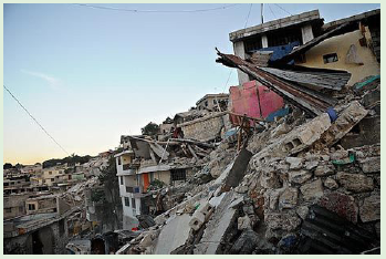
2. Propose measures that can be taken to curb the effects of thehazard/disaster presented in the picture above.
ii. Consequences and measures to alleviate earthquake effects
a) Consequences of earthquakes
The following are consequences earthquakes:
• Loss of life and destruction of property happens when violent shaking
of the land causes cracks on walls and making the buildings to collapse.
• Outbreaks of fires occur where the earthquake destroys oil and gas pipelines.
• Occurrence of Tsunamis which are huge sea waves and are very destructive
• Landslides occur when; sudden movements of large masses of rock
and soil downhill.
• Displacement of crustal rocks. This is takes place vertically and
laterally, leading to damaged transport and communication lines such
as roads and railways.
b) Measures to alleviate earthquake effects
The measures for alleviating the earthquakes include the following:
• Building houses in a way that they are more resistant to earthquakes.
• When one is outside, should stay move away from buildings and
streetlights.
• If trapped under a collapsed structure tap on a pipe or wall so that
rescuers are able to locate you.
• When the shaking stops, look around to make sure it is safe to move.
Then leave the building.
Application Activity 6.10
It has been noticed that Western part of Rwanda experiences earthquakes
at great extent compared to other regions of Rwanda.
a) Suggest why that part of Rwanda experiences such phenomenon.
b) What do you think are the effects of such catastrophe/disaster in
any region where it occurs?
c) Assume that you are in charge of disasters management; proposemeasures that should be taken to control earthquakes.
Skills lab
The landform evolution and processes have a great impact on landform.
Examine the internal landform susceptible to change the surface of your local area.
End unit Assessment
1. Discuss the impact of faulted landforms on the East African
landscape and drainage
2. Explain the significance of folded relief features in the socioeconomic
development of East Africa.
3. With specific examples, explain the importance of warping on
drainage system of Africa.
4. Critically examine the effects of either Tsunami in Japan or
earthquake in Haiti on the World economic development.
5. Assume that you are appointed as Director General of Rwanda
Environmental Management Authority (REMA), what are
measures that you should reinforce for conserving the basin lakesand wetlands found in Eastern province.