General
- Geograpy SSE Y2 SB File Uploaded 2/11/21, 16:08
- Geograpy SSE Y2 TG File Uploaded 2/11/21, 16:07
UNIT 2:BEARINGS, DIRECTIONS, DISTANCES AND AREAS ON A MAP
Key Unit competence : The student-teachers should be able to measure
the bearings and the directions, calculatedistances and areas on a map.
Introductory activity
Maps are very important in showing location of places. Study the topographicalmap of Rwanda provided below, and answer the questions that follow.
a) How do we locate places on maps using grid references?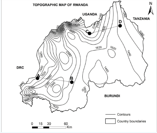
b) Determine the distance from point A to B and C to D?c) Identify the steps to be followed to determine the bearing of B from A.
2.1. Location of places using the grid references
Activity 2.1
Map
a) A map has several printed lines on it. Show the vertical and horizontal
lines printed on the map. Identify them.
b) What does grid reference mean?
A grid is a series of straight lines drawn vertically and horizontally on a
topographical map, where the lines cross each other and form squares of equal
sizes. The lines running from north to south (vertical lines) are called Eastings.
This is because their numbers increase towards the east from the south western
corner. This is known as the grid origin and it is from it that all readings start.
Lines drawn horizontally run from east to west and are called Northings. Theirnumbers increase towards the north.
The lines shown on the illustration above intersect forming grid squares. These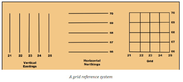
are formed by both vertical lines (Eastings) and horizontal lines (Northings).
These are called grid references or geographical coordinates. They are the
ones that are used to locate places and features indicated on the map. This isillustrated below:
The value of the easting (vertical gridline) is read first, followed by the value of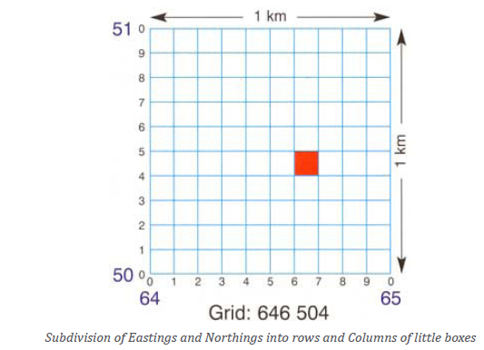
the northing (horizontal Gridline). The values of the Eastings and Northings are
known as coordinates. The coordinates are expressed as a single continuous
figure without decimal points or commas, for example, 646 504 and not
646,504. They are plain numbers, without units of measurements.
The coordinates are given in two ways:
─ Four-figure grid reference
─ Six-figure grid reference
2.1.1. The four-figure grid reference
The four-figure grid has four digits. It gives the grid reference in which a position
is found. The four-figure grid references of the yellow square, in figure below,
are found as follow:
• Read the easting first and record its value. In this case it is 11.
• Next read the northings and record its value. In this case it is 81.
• Put the two values together.• The four-figure grid reference for the square is 1181.
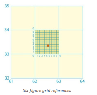
2.1.2. The six-figure grid reference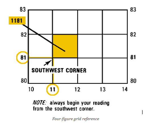
This reference has six digits. It is more exact than the four-figure grid reference.
To find the six-figure grid reference for the red square in figure below is done
in the following ways:
• Read the easting first and record its value. In this case it is 62;
• Subdivide the area between easting 62 and 63 into 10 equal parts;
• Record the value of red square out of 10 from easting 62. In this case,
it is 5. This forms the third digit of the easting;
• The value of the easting for red square is therefore 625;
• Read and record the northing. In this case, it is 33;
• Subdivide the area between northing 33and 34 into 10 equal parts;
• Record the value of red square out of 10 from northing 33. In this case,
it is 3. This forms the third digit of the northings;
• The value of the northing is therefore 333;• The six-figure grid reference for red square is therefore 625333.
Application Activity 2.1
Study the extracted map below and answer the questions that follow
1. Give the four-grid reference of the Geo farm.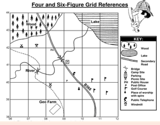
2. Identify the six-grid reference of two bridges shown on the map.
2.2. Starting directions and bearings on topographic maps
Activity 2.2Look at the picture below and answer the following questions
1. What do you understand by the term direction?
2. Explain the relationship between directions and bearing on the map.
2.2.1. Direction
Direction or orientation is important for finding the position of a place and its
relative. All directions are based on the cardinal points of the compass shownbelow:
Direction is the relative position of a place from another using the points of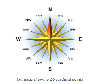
the compass. The main cardinal points of a compass are north, east, south and
west. The first letters of these directions are used in capital letter in place asthis. These are N-North, E-East, S-South, W-west.
2.2.2. Bearing
Bearing is a way of giving the direction of one place in relation to another. It
is more accurate than direction because it has 360 points compared to the16
points of a compass. Instead of saying, for example, that place A is located north
east of place B, we use degrees. So, we could say that place B is situated at 450
from place A
The bearing of a point is the number of degrees in the angle measured in a
clockwise direction, from the North line to the line joining the center of the
compass with the point. It is used to represent the direction of one-point
relative to another point.
For example, on the following diagram, the bearing of A from B is 2450, thebearing of B from A is 650.
Bearing is also the direction to something measured as an angle relative to the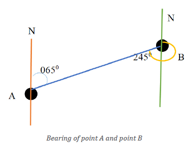
north. It increases towards the East, with North=0 degrees, East=90degrees,
South=180 degrees, and West=270 degrees.
2.2.3. Measuring true bearing
The true bearing (TB) is the bearing where the true-north line is taken as 00.
It is the measurement between the true-north line and the line joining the two
places concerned. It is measured by using a protractor from the true North, as
the example below:
• Draw a north-south line through the starting point.
• Use a straight line to join the two places given.
• Draw an arrow from the true North line to the line joining the two
places in a clockwise direction, and the angle is measured with aprotractor.
In this case, the bearing of B from A is therefore 1350.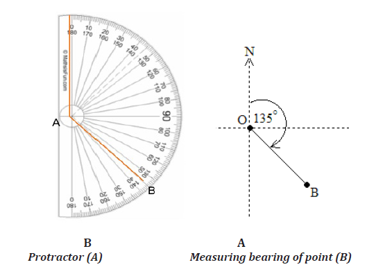
How to use a protractor?
• The centre of the protractor is over the starting point and orient
0 degree with the true north.
• Draw a line on the map from the starting point towards the destination,• Read the bearing where the line intersects the protractor.
Application Activity 2.2Study the illustration shown below and answer the questions that follow.
Determine the bearing of: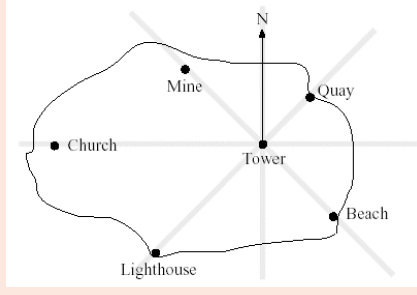
a) The Beach from the Tower.
b) The Tower from the Church.
c) The Mine from the Tower.d) What is the direction of the church from the Quay?
2.3. Measure the distance on the maps: Straight line and curved line
Activity 2.3
Read the conversation between Eric and Sophie, students in S1B, and
answer the questions:
Eric: I want to visit my uncle at Gasabo district.
Sophie: Can we walk from Kabuga market to Gasabo district?
Eric: I don’t know, let us look at our map. It has a ratio scale of 1:50 000.
On the map, it is 20cm from Kabuga to Gasabo district.
Using our map skills, that you have acquired in your previous studies:
─ Calculate the actual distance on the ground.
─ Can Eric and Sophie walk in two hours from Kabuga market toGasabo District? Support your answer.
A map is a representation of actual ground on the paper. It is usually drawn
using a scale.
Distance on the map is calculated between two points, and then it is converted
into the actual distance on the ground. The distance can be either a Straight line
or a curved line.
The most important is to know how to calculate the distance.
The following methods are used to measure the distance.
2.3.1. The Straight Line distance
The shortest distance between two points is sometimes known as “the crow
flies.”
── use the ruler and measure the distance between two points in
centimetres;
── convert the centimetre reading to kilometre by multiplying by 0.5km
if the map scale is (1:50 000) to obtain the kilometres on the ground.
Example, the distance of the crow flies from P and Q is 8.5cm on the
map, therefore 8.5cm x 0.5km =4.25 km on the ground.
1 cm
A map scale refers to the relationship (or ratio) between distance
on the map and the corresponding distance on the ground. The
map scale shows you the comparative size of features and distances
display on the map.
── check the scale of the map,
── and convert the distance between the two points into the real distance
on the ground.
The answer above should be converted to the unit for ground distances (km).
N.B. An alternative method is where a piece of string is used to measure the
curved or winding line. Make sure that the string is not elastic.
Formula:Actual distance = Map distance x Scale.
2.3.2. Curved distance
In map reading, there are sometimes curved or straight areas while determining
the distance.
Below, there are some steps to follow to calculate curved Distance.
── place the straight edge of the paper along the features to be measured
e.g. road, river;
── make a mark where the paper intersects the road;
── hold the paper steady with the point of a pencil;
── swivel paper;
── mark where paper intersect with the road;
── write down the reading after measuring the road or river;
── check the scale of the map,
── and convert the distance between the two points into the real distance
on the ground.
The answer above should be converted to the unit for ground distances (km).
N.B. An alternative method is where a piece of string is used to measure the
curved or winding line. Make sure that the string is not elastic.
Formula:Actual distance = Map distance x Scale.
2.4. Calculate the area on topographic map: regular and irregular shape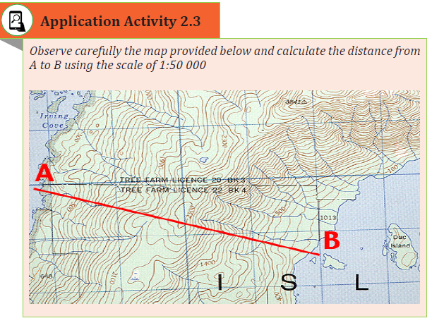
Activity 2.4
An area is calculated to determine the actual (size on the ground) of a feature/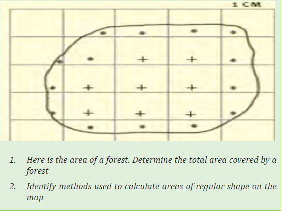
region/ demarcated area. The area of a feature can be regular or irregular in
shape.
2.4.1. Calculate areas of regular shapes
Getting the area of a regular body on the maps is simple. This is because the body
may be a square, rectangle, triangle, or a circle. Once the distances obtained, the
mathematical formula are used.
── Square and rectangle: multiply the length by the width
── Triangle: half base multiplied by height── Circle: Pi multiply by square of radius.
2.4.2. Calculate areas of irregular shapes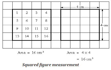
The following methods are used to calculate the area of irregular shapes:
1. The use of grid squares
On topographical maps of the scale 1:50,000, there are grid squares measuring2 cm by 2 cm.
On the ground, these measure 1 km by 1 km. It means that they have an area of 1 km2.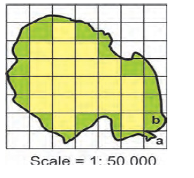
To calculate the area of irregular shapes, we need to perform the following
steps are performed:
• Count all the full squares inside the irregular body.
• Count all the half squares inside the irregular body and divide them
by two.• Add the total of the full squares and the half squares.
For example:
Formula:
Full squares= 20
Half Squares=26
Get 26 halves divide by 2 =13 full squares
20 +13=33 full squares X the area of one square
33 x1 square km
=33 km Squared.
2. The use of strip method
The strip of equal width is drawn on the irregular body. The length of the strips
differs from strip to strip.
Follow the method used to find the area of regular shapes. Calculate the area
of each strip. Add the areas of the various strips. This gives you the area of theirregular shape.
3. Use of rectangles and triangles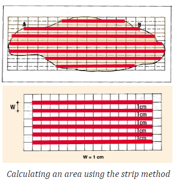
The irregular body is divided into a rectangle and triangles as shown below.
Their measurements are recorded. The formula for finding the area is used(known). Then get the totals of these areas.
Application Activity 2.4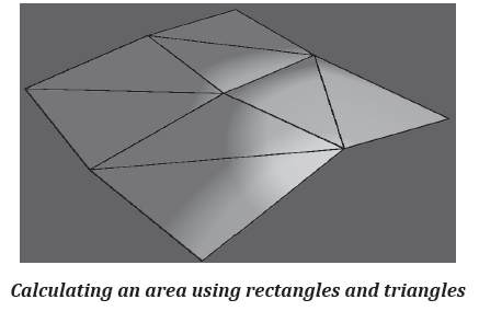
Using your knowledge, identify how you can calculate the area of a farm if
the measurement got are 45 m length, and 34 m width.
Skills lab
In your school environment, use the school plan to calculate the area of your
school compound and submit it to your school leader, then compare the resultobtained to the real area of the school.
End unit Assessment
1. Calculate the grid references for the points A, B and C on the figure: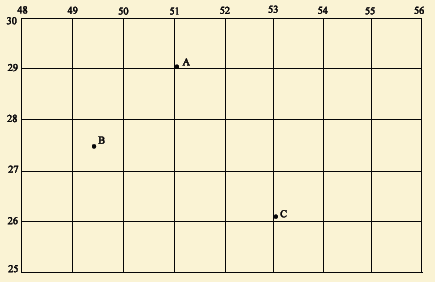
2. Study the Topographical map below and calculate the actual distanceon the ground between the point A and B; X and Y on the Map.
3. Mugisha and Mucyo are traders in Kigali and they export goods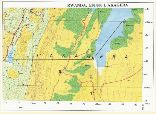
made in Rwanda and import some commodities that are not
locally produced. Sometimes goods delay as they are being
transported from Mombasa port. Suppose you want to travel
with these traders, explain how you would use a map to find out
the distance from Kigali to Mombasa.
4. Suppose someone comes from Europe to visit Rwanda, specifically
Muhoza sector, in Musanze District (see the map below). At Kigali
airport someone gives him a map with a scale of 1:50,000. He/ she
needs to know the bearing of Muhoza from Kigali.
── Show how you would find the bearing of Muhoza if this visitor
asked for guidance.── What is the relative position of Muhoza from Kigali?