General
- Geography SSE Y3 SB File Uploaded 2/11/21, 16:09
- Geography SSE Y3 TG File Uploaded 2/11/21, 16:08
UNIT 8: GLOBAL DRAINAGE SYSTEMS
Key Unit competence
The student-teachers should be able to investigate the economic importanceof the global drainage systems and the reasons for their conservation
Introductory activity
1. Do research using the internet and other geographical resources
to explain the following drainage terms: Drainage system, river
discharge, river velocity, catchment area, river divide and river basin
2. Explain the processes of river erosion, river transportation and river
deposition.
3. Explain the importance of drainage systems4. Discuss why there is need to conserve drainage systems
8.1. River system
Learning activity 8.1
1. Do research and explain the types of rivers and the river profiles.2. What do you understand by the concept of a river profile?
8.1.1. Definition of a river and the associated terms
A river is a large natural stream of fresh water flowing along a definite course,
usually into the sea, being fed by tributary streams. The water originates from a
known source and empties into a sea, lake or another river. The river flows alonga channel, whose water volumes increases as the river goes downstream.
The following terms are used in describing a river channel
Discharge: is the amount of water originating from precipitation which reaches
the channel by surface runoff, through flow and base flow. Discharge is,
therefore, the water not stored in the drainage basin by interception, as surface
storage, surface moisture storage or groundwater storage or lost through the
evapotranspiration.
River Velocity: Is the speed at which the water flows through the channel. It is
less at the sides and bed than at the center of a river. The velocity also depends
on the river’s gradient.
A river Basin: Is an area of land drained by a river and its tributaries. Its
boundary is marked by a ridge of high land beyond which any precipitation will
drain into adjacent basins. This boundary is called a watershed.
A river divide: This is the crest of the upland or mountain from which the
streams flow down the slopes on both sides to their journey.
River width: This is the distance across the surface of a river from one bank to
another bank.
River depth: Is the vertical distance from the river surface down to its bed.
River slope, also called river gradient is the angle between the horizon and
the river surface.
Catchment area is an area from which a river derives its water. This can be anupland or mountain.
8.1.2. Types of rivers
There are different types of rivers. The following are the main ones:
• Perennial River: This is a river with water flowing permanently in its
channel throughout the year.
• Intermittent River: This is a semi-permanent river which stops flowing
at some point in space and time. It stops to flow every year or at least
twice every five years.
• Ephemeral River: This is a seasonal river that flows only when thereis heavy rain or when snow has melted.
8.1.3. The river system: The work of a river
As a river moves from its source to its mouth, it performs the triple function
(three phases) of erosion, transportation and deposition. The following is the
work of a river:
A. River erosion
This involves the removal of different soils and rock particles of varying sizes
from the river’s bed and banks. Erosional work of rivers depends on the channel
gradient, the volume of water, the river’s velocity, water discharge and the
sediment load (amount of eroded material). The river erosion is at its peak when
the river passes through a steep gradient where the speed of flow is great. The
river erodes its bed and channel in the following ways:
• Hydraulic action: This is the process by which fast flowing water
enter into the cracks on the river bed and channel sides. The repeated
friction and pressure of water force cracks to widen and finally erode
weaker rocks.
• Solution or corrosion: This is the removal of rocks like salt, limestone
etc. that are soluble in water. Such rocks dissolve in water and are
carried in solution form.
• Abrasion or corrasion: This is the erosion of the river’s bed and
channel sides by the rolling action of materials or river load against rocks.
The heavier rocks transported in water rub and slid against the bed and
channel rocks eroding them as they are transported downstream.
• Attrition: This is the erosion of the river’s load by the load itself. As
rock fragments moving as load are transported downstream, boulders
collide with other material and they are fragmented and gradually
reduced in size, and their shape changes from angular to rounded.
B. River transportation and types of steam loads
Rivers transport refers to the carrying away of eroded material downstream.
As represented on figure below, rivers transport their load in the following ways:
• Solution: This is the downstream movements of soluble material like
salt, carbonates dissolved in water.
• Suspension: This is where the light particles of plants, soil and rocks
are carried away while floating or maintained within the turbulence flow of water.
• Saltation: This occurs when the load carried by the river is transported
in a series of short jumps or hops. It involves the transportation of
particles which are not too heavy but cannot remain suspended in
water. Materials such as pebbles, sand and gravel are temporarily lifted
up by the river currents and then dropped back along the bed in a
hopping motion. Such movements are known as hydraulic lift.
• Traction: This is where large and heavy materials are rolled, pushed
and dragged downstream by the force of moving water. Such materialsinclude rocks, pebbles and boulders.
Transport of solid load in a stream: Clay and silt particles are carried in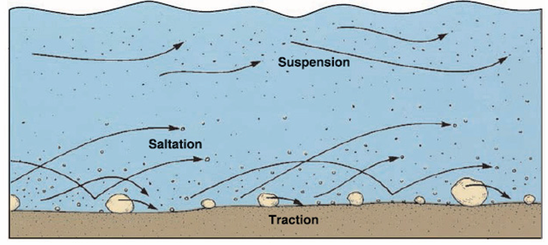
suspension. Sand typically travels by suspension and saltation. The largest
(heaviest) particles move by traction.
There are three main types of stream load.
1. Mineral and chemical elements of rock material held in solution constitute
the dissolved or solution load.
2. Suspended load consists of the small clastic particles being moved in
suspension.
3. Bed load is constituted of larger particles that move in traction along thestreambed.
C. River deposition
This refers to the situation where a river fails to transport its load. The river, then
drops its load due to the reduction in its energy. The heavy load is selectively
deposited first, while the fine and lighter particles are deposited last. The materialdeposited by a river is referred to as alluvium.
8.1.4. The river profile and its characteristics
A river profile is a section through the river channel from its source to its mouth
or from one bank to another. There are two types of river profile: cross profile
and long profile.
– Cross profile
This is also known as the transverse section of a river. It is the shape a river
assumes from one river bank to the other. It develops as a result of down
cutting and lateral cutting of the riverbed and banks by water currents. This
undercutting makes a section of a river valley, have different shapes and forms.For example, in the upper valley, vertical erosion produces a steep “V”-shaped
valley. However, this depends on the rate of erosion and weathering takingplace on the valley sides.
In the middle and lower stages, the river valley begins to become shallow andwide due to increased lateral erosion. The valley assumes a “U” shape.
– Longitudinal profile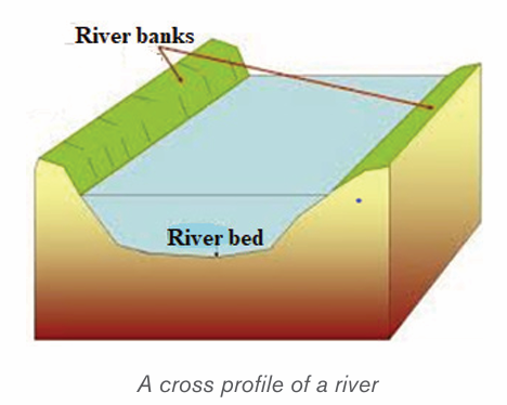
This is the longitudinal section of a river. It contains a variety of erosional and
depositional features. Based on its distinctive characteristics, the long profile of
a river is divided into three stages (upper/youthful, middle/mature and lower/oldstages) known also as normal cycle of erosion
The Course of a river presents three successive stages. They are represented
on figure bellow and described as follows:
• The youthful stage, referred to as upper stage of a river is found in
the mountains and hills where the river rises from its source. It has the
following characteristics:
– The topography at this stage is steep and the river is usually fast
flowing in the upper course.
– The main river gradually deepens its valleys.
– Often waterfalls and rapids are also found in this course;
– The main type of erosion is vertical. The valleys are narrow and deep.
– The features found in this stage include gorges, rapids and
waterfalls.
– There are lots of stones and boulders for the water to flow over.
The river starts as a stream in the upper course and flows throughV-Shaped valleys.
• Mature stage is known as valley stage. This middle course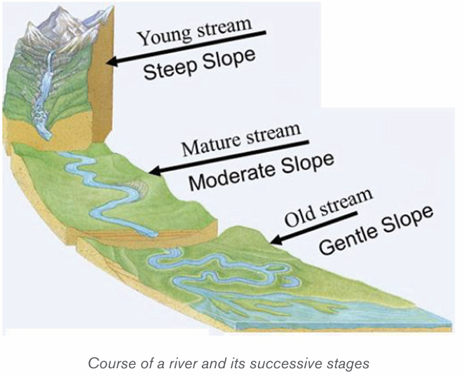
corresponds to the mature stream and presents the following
characteristics:
– This is the stage between the upper and lower courses of the river;
– The slope of the riverbed is reduced, and the speed of the water is
also reduced;
– The main type of erosion is lateral and the river begins to widen its
channel. There is also some deposition of sediments;
– More tributaries join the river, leading to a large volume of water;
– The river begins to meander or follow a winding course;
– The features found in this stage include cliffs, slip-off slopes and bluffs.
• Old stage, also known as the old stream, is the lower course
where the river becomes its widest and deepest. It has the following
characteristics:
– The slope of the river is very gentle; therefore, the river flows slowly.
– The valley is shallow, wide and flat.
– Seasonal floods occur.
– There is a lot of deposition of sediment on its bed.
– The features found in this stage include ox-bow lakes, deltas,floodplains etc.
Application activity 8.1
1. Explain the major work of a river.
2. Describe the characteristics of a river that you observe in your local
environment and how that river affects the environment around.
8.2. Formation of the major landforms associated with a river profile
Learning activity 8.2Observe the diagram below and answer the following questions.
1) Name the landforms labeled a, b, c, d and e;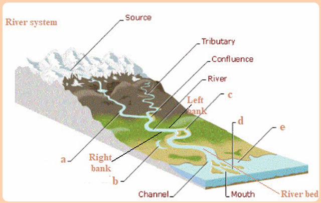
2) Apart from the features named above, what are other landformscreated by a river?
8.2.1. Formation of landforms in youthful stage
Youthful stage is the first stage of a river near its source. This stage is
characterized by a steep gradient, fast flowing water, vertical erosion etc. There
are several landforms that are created in this stage especially due to vertical
erosion and the nature of the gradient. The landforms like waterfalls and rapids,potholes and plunge pools are the main landforms:
i) Waterfalls and rapids
Waterfall refers to movements of water or simply sudden descents of water
due to abrupt breaks in the longitudinal course of the river. Waterfalls are mostly
caused by variations in the relative resistance of rocks and topographic reliefs.
A waterfall, therefore, is a vertical drop of a big volume of water from a great
height along the profile of a river.
Rapids are alternate breaks along the river’s profile. Rapids are smaller than
waterfalls. Generally, they are found upstream from the main falls, and are alsofound independently.
ii) Potholes and Plunge pools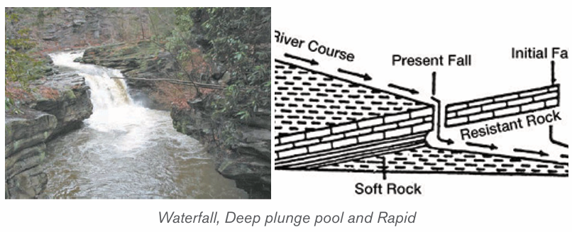
These are kettle-like and cylinder-shaped depressions in the rocky beds of the
river valley. They are circular depressions cut at the bed of the river by fast
flowing water. They are formed due to saltation and traction movement of large
pebbles and boulders on resistant rocks. Plunge pools are formed when pot
holes are further widened and deepened by circular and fast movements of water.
iii) Interlocking spurs
These are alternate bands of resistant rocks or hill sides formed when the river
attempts to avoid hard and resistant rocks on a steep gradient. The hard rocksare not eroded hence, the river meanders between interlocking headlands.
8.2.2. Formation of landforms in mature stage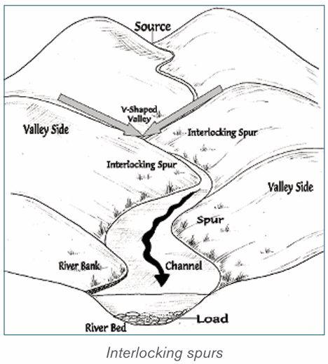
A mature stage of the river is the middle stage of a river’s course where the
gradient is lower and where the river begins to flow slowly as it widens itschannel.
The following are the major landforms:
i) River valleys: The valleys carved out by the rivers are significant erosional
landforms. The shape and dimension of fluvial originated valleys change
with the advancement of the stages of fluvial cycle of erosion.
ii) Gorges and Canyons: Are very deep and narrow valleys with steep
sides/slopes that are wall-like. They are formed when water falling over
the hard rock, undercuts the rock leaving it hanging. The hanging rocks
may cause water to retreat upstream leaving behind a narrow and deepsided valley
iii) Alluvial fans: These are fan-shaped deposits of coarse alluvium. They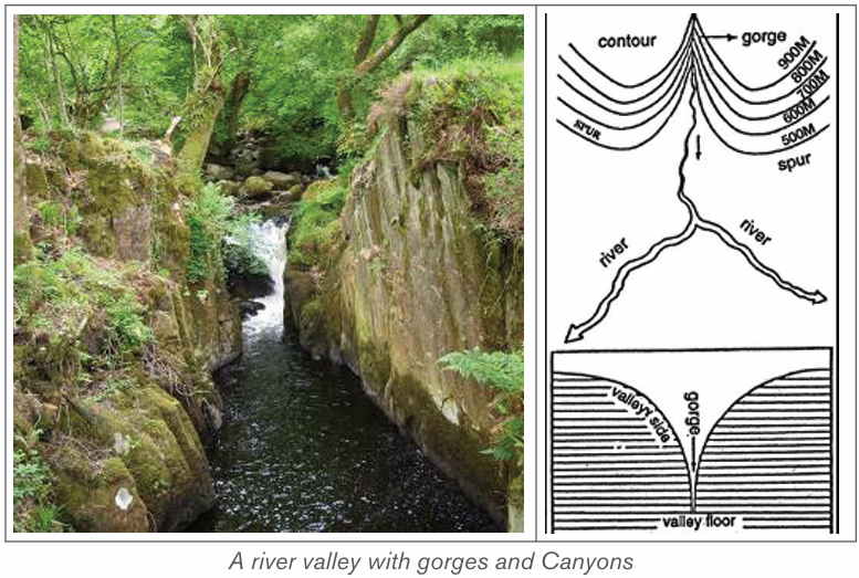
are formed when a fast flowing river loses its velocity when it enters the
gentle slope. The river immediately deposits its load composed of course
materials especially rocks, boulders and bigger pebbles. The depositsare laid in form of a fan, hence the name, “alluvial fan”.
iv) River Benches: These are step-like flat surfaces on either side of the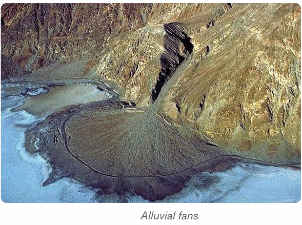
lowest valley. The benches or terraces formed due to differential erosion
of alternate bands of hard and soft rock beds are called structural
benches or terraces because of lithological control in the rate of erosionand consequent development of benches.
v) River terraces: The narrow flat surfaces on either side of the valley floor
are called river terraces which represent the level of former valley floorsand the remnants of former (older) flood plains.
8.2.3. Formation of landforms in old stage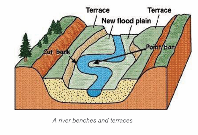
The lower or old stage of river is the last stage where a river nears its destination.
This stage is characterized by large deposits along the river’s bed and channel.
The large deposition is a result of increased lateral erosion, very slow movement
of water and very wide river channel. In this stage the river drops its load due to
the reduction in its energy. The material deposited by a river is called alluvium.
River deposition results into the formation of the following features:
i) River meanders
River meanders are the bends of the rivers. The bends of sinuous rivers have
been named meanders on the basis of Meander River of Asia Minor (Turkey)
because it flows through numerous bends. Each bend of the meander belt
has two types of slopes of valley sides. One side is characterized by concave
slope while the other side of the meander belt is characterized by convex slope.
The convex or slip off slope receives deposition mostly of sands and gravels
and alluvium at other times. Therefore, the bank of maximum deposition is also
called a slip-off slope. The concave slope is a bank of maximum erosion orundercutting. It is steeper than the slip-off slope.
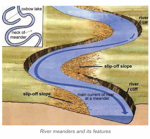
ii) An Ox-bow lake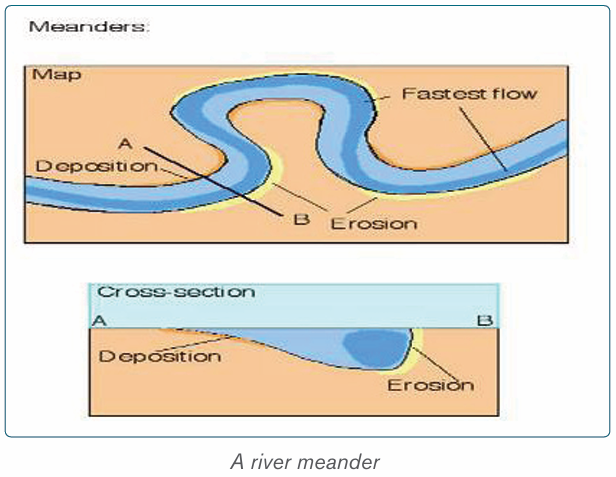
This is a horse-shoe lake formed due to stagnation of water in the abandoned
meander loop. Ox-bow lakes are formed when a river develops very pronounced
meanders in the flood plains. As erosion and deposition continues on the river’s
banks, the neck of the meander is cut off and the water flow straight by-passing
the old meander. The abandoned or cut off meander therefore becomes an oxbow lake.
iii) Flood plain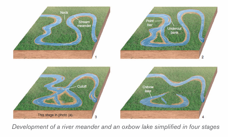
This is a very gentle low-lying plain of alluvial deposits on a floor of a river valley.
It is formed where a river flows in a meandering way. As a river swings back and
forth across the valley, it widens its valley floor. The valley becomes so broad
that the meanders swing freely without touching the valley sides. When the level
of water rises during the flood time, all the plain along the river valley becomesflooded. The river then deposits its alluvium in the plain.
iv) Levees
These are raised river banks made up of alluvial deposits. Levees are formed
when a river deposits its load along its banks during flooding. Slightly coarse
materials are deposited on the banks, while finer alluvium is transported further
onto the flood plains. With time, accumulation of coarse material raises the
banks of the river to form levees. During the dry seasons when the river retreats
into its channel, deposition are left both on the river’s bank and on its bed. Thisleads to the formation of raised river beds and banks.
v) Deferred tributaries
These are small tributary rivers that flow alongside the main river. They are
formed when raised levees stop tributaries from joining the main stream. As a
result, such tributaries, flow parallel to the main river until they encounter a break
in the river bank where they now can join the main stream. They are thus referred
to as deferred tributaries or Yazoo streams. The point at which they join the main
stream is referred to as a deferred confluence. The tributary flows to the mainchannel and finally break through levees and join the main channel.
vi) Braided channel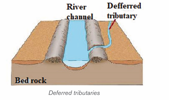
This is a wide and shallow channel where a river breaks into a series of
interconnecting distributaries separated by sandbanks and islands of alluvium. It
is formed in the middle or old stage of a river where the valley is wide and gently
sloping. The river carrying a large load flows at a low velocity, fails to transport
its load and finally deposits its load on the bed. Gradually, the river bed is raisedand the deposits divide the flow of water into small tributaries and distributaries.
vii) Delta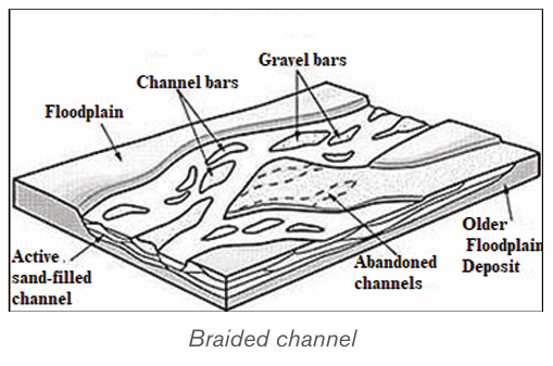
A delta is a low-lying swampy plain of alluvium at the mouth of a river. A delta
forms when a river fails to carry its entire load into the sea or mouth but deposits
these into its mouth. The deposits divide the river’s mouth into tributaries and
sub tributaries. The deposits gradually become colonized by various types of
plants and form a triangular shaped mouth of a river. This is called delta. The
river splits up into several separate channels in much the same way as river
braids. Deltas are classified into three categories depending on the shape and
growth where there are growing deltas and blocked deltas. They include the
following:
• Estuarine deltas,
• Arcuate deltas,
• Bird’s foot deltas.
– Estuarine delta: This is a submerged mouth of a river. It is a delta formed
from materials deposited in the submerged mouth of a river. This takes the
shape of the estuary. Examples are the Zambezi Estuary in Mozambique,
and Volta Delta in Ghana.
– Arcuate delta: this is a triangular and convex shaped delta. It is formed
by a river with many distributaries transporting materials. It occurs where
off-shore currents are strong enough to round the seaward edge of the
delta. Examples are Sondu Delta in Kenya, Nile Delta in Egypt and Amazon
Delta in Brazil.
– Bird’s foot delta: This is a delta that looks like the claws of a bird’s foot.
It is also known as digitate delta. It is formed when a river transporting
large load of mainly fine material enters into water that has low energy wave.
The distributaries extend from the shore into the open water. Examples areOmo River Delta on Lake Turkana and Mississippi Delta in the USA.
Application activity 8.2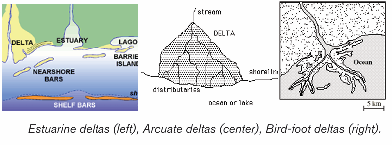
1. Visit the nearest rivers and do the following:
i) Identify the landforms formed along a river.
ii) Explain the importance of the above landforms to the local people.
2. Describe the relationship between landforms in the lower stage of ariver and human activities
8.3. River capture, river rejuvenation, superimposed and
antecedent drainage and impact of rivers
Learning activity 8.3
1. Make a research and establish the effects of the river capture and
river rejuvenation.
2. Identify how superimposed and antecedent drainage are formed.3. Discuss the importance of rivers.
8.3.1. River capture
A) Definition of river capture
River capture refers to the diversion of headwaters of a weaker river system into
a system of the stronger neighboring river. It is also referred to as river piracy.
The point of capture is known as “elbow of capture”. This point is usually found
near the dry valley or misfit stream. A misfit stream is the river whose water
has been beheaded or diverted into another stream. It contains very little or no
water at all and is not therefore fit to be in that river. This is why it is called misfit
stream. Beyond the misfit stream is a valley that no longer contains water. It isonly covered by old alluvial deposit. This is called a dry valley.
B) Features of river capture
There are four major features of river capture: elbow of capture, cols or windgaps, misfit or under fit streams and dry valleys.
C) Causes of river capture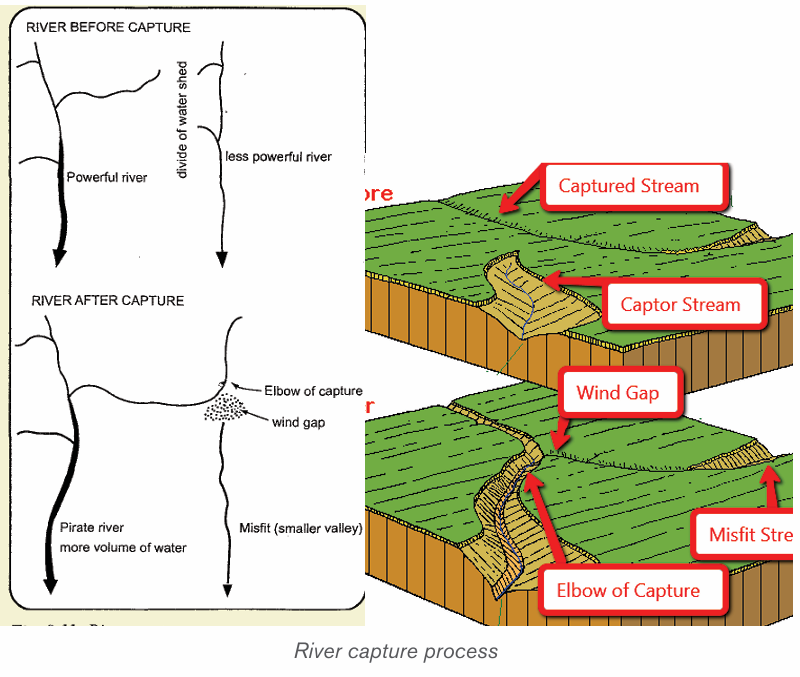
A river capture can be caused by headward erosion, lateral erosion, or
coalescence of meanders. The following are the causes of river capture:
• The presence of a river with a larger volume of water compared to its
neighbour (the weaker river). The stronger river erodes its valley faster
by vertical erosion compared to its neighbour.
• The presence of soft and easily eroded rocks in the valley of a stronger river
• Earth movements like faulting, folding, warping and volcanicity on the
valley of a stronger river can also cause river capture
• Change in base level as a result of river rejuvenation. A fall or rise in a
river’s base level can cause river capture
For river capture to take place, the following conditions are necessary:
• There must be a powerful river or pirate stream and a misfit stream
flowing adjacent or parallel to each other.
• The pirate river must be flowing over a much steeper valley than the
misfit or beheaded stream
• The pirate river must be having more active head ward erosion compared
to its neighbouring river
• The pirate river must be flowing over easily eroded rocks compared to
those of its neighbour
D) Effects of river capture
The following are the effects of river capture (after the occurrence of river
capture):
• The volume of water in the pirate stream increases;
• The capturing/beheading river becomes bigger and more stronger than
it was before capture;
• The beheaded stream having lost its waters contains very little water
and almost dries off (a misfit river);
• The pirate river develops an elbow of capture. This denotes a sharp
change in the direction of a river course (at the point of capture);
• The valley of the beheaded stream below the point of capture becomes
dry and hence the name, “wind gap”;
• Incision of the pirate river near point of capture. This valley becomes
wider due to increased vertical erosion (head ward erosion).
8.3.2. River rejuvenation
A) Definition of river rejuvenation
River rejuvenation is the renewed erosive activity of a river. It is an acceleration
of erosive power of the fluvial process of rivers. Rejuvenation length is the period
of the cycle of erosion. For example, if the cycle of erosion is passing through
senile stage (old stage) characterized by gentle channel gradient, sluggish river
flow and broad and shallow alluvial valleys, after rejuvenation (caused either
due to substantial fall in sea level or due to uplift of landmass) the cycle is
interrupted and is driven back to juvenile (youth) stage characterized by steep
channel gradient and accelerated valley incision.
There are three types of rejuvenation as follows:
i) Dynamic rejuvenation: It is mainly caused by uplifting in the landmass,
tilting of land area and lowering of the outlet.
ii) Eustatic rejuvenation: This occurs because of changes in sea level
due to diastrophic events (subsidence of sea floor or rise of coastal land)
and glaciations causing fall in sea level.
iii) Static rejuvenation: Its main causes are decrease in the river load,
increase in the volume of water and consequent stream discharge due
to increased rainfall, increase in water volume of the main river due to
river capture.
B) Causes of river rejuvenation
River rejuvenation is caused by the following:
• A fall in base level or fall in the level of the sea.
• Earth movements involving uplift, down faulting
• River capture which may cause an increase in the volume of water (river discharge)• Change in rock resistance
C) Effects of river rejuvenation on the landscape
River rejuvenation produces several features as follows:
• Knick point: This is a break of slope in the long profile of a river valley.
It indicates the point where rejuvenation started. Knick points are
associated with rapids and water falls.
• Paired terraces: These are steps or bench-like river valleys on both
sides of a rejuvenated valley. They are marked by old alluvial deposits
laid down before river capture occurred. It is therefore a part of the
former flood plain valley that is above the present river level.
• Incised meanders: An incised meander is a curved bend of a river
that has been incised or cut into the land surface so that a river now
winds between steep valley walls. Incised meanders develop from an
already meandering river.
• Ingrown meanders: These are incised meanders with asymmetrical
steep valley sides. They develop on resistant rocks and where the base
level falls gradually and the meander shifts gradually and laterally
• Valley within a valley: This is also referred to as a rejuvenation gorge.
These are steps at the opposite sides of a rejuvenated valley. They form
where rejuvenation was very rapid with a large fall in base level. The
river flows in a deep channel within paired terraces that were once theremains of the flood plain.
8.3.3. Superimposed and antecedent drainage
A) An antecedent drainage
This is a drainage made of streams that maintain their original course and
pattern despite the changes in underlying rock topography. Antecedence is
when the drainage pattern developed before such structural movements as the
uplift or folding of the land, and where vertical erosion by the river was able to
keep pace with the later uplift. A stream with a dendritic drainage pattern for
instance, can be subject to slow tectonic uplift. However, as the uplift occurs,
the stream erodes through the rising ridge to form a steep-walled gorge. The
stream thus keeps its dendritic pattern even though it flows over a landscapethat will normally produce a trellised drainage pattern.
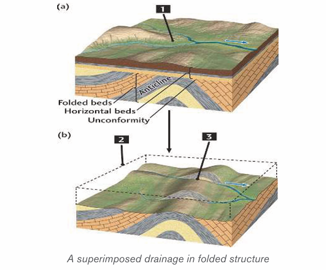
B) A superimposed drainage
This kind of drainage pattern seems to have no relationship to the present-day
surface rocks. Superimposed pattern is a drainage that formed over horizontal
beds that overly folded and faulted rock with varying resistance. The stream
erodes through the underlying horizontal beds, and retains its course and
pattern despite changes in the underlying rock. The stream erodes a gorge inthe resistant bed and continues its flow as before.
8.3.4. Impact of rivers
Rivers play an important role both to human beings and the surrounding
environments. Rivers can also negatively affect people and the surroundingenvironments.
A) Positive impacts of rivers
The rivers and riverine landforms present the following advantages for humans:
– Rivers provide water for various uses such as domestic, industrial uses,
drinking by animals;
– Navigable rivers provide natural route-ways used for transportation;
– Rivers provide water for irrigation especially in areas of low rainfall. This
promotes agriculture, hence increasing food production;
– Waterfalls provide natural sites for the production of hydroelectric
power. Examples are: waterfall between lakes Burera and Ruhondo,
River Rusizi in Rwanda, River Tana in Kenya, River Volta in Ghana, water
falls along River Nile, etc;
– River Ria, estuaries and deltas are deep and sheltered, hence they
promote the development of ports like Alexandria on the Nile delta;
– Building materials such as sand, gravel and pebbles are obtained from
river beds and valleys;
– Some rivers have spectacular features such as waterfalls, gorges and
canyons which attract the tourists. For example, Rusumo falls on river
Akagera in Rwanda;
– Alluvial deposits in some river valleys are a source of valuable minerals
such as alluvial gold for example in Miyove valleys in Northern Province
of Rwanda;
– Building materials such as sand, gravel and pebbles are obtained from
riverbeds and valleys;
– Flood plains and deltas contain fertile alluvial soils which have been
exploited for agriculture. Example is the Nyabarongo river valley, Nile
valley in Egypt etc;
– The livestock activities are mostly developed near water bodies wheredrinking and green vegetation water is available throughout the year.
B) Negative effects
The following are some of disadvantages of rivers and riverine landforms that
influence negatively humans:
– Some large rivers form barriers to communication between communities
of the same culture;
– During flooding some rivers cause destruction of property and loss of
human life;
– Some river water may act as a medium for the spread of water borne
diseases, for example, Malaria, Bilharzia;
– Some rivers host dangerous animals such as crocodiles and
hippopotamuses. These at times attack human beings and destroy crops.
Application activity 8.3
1. Using your knowledge and skills acquired in this unit, explain the
factors that favour river capture.
2. Examine the difference between river capture and river rejuvenation.
3. Analyze the impact of rivers to the development of the country.
8.4. Lakes, Seas and Oceans
Learning activity 8.4
1. Identify any 5 lakes found in Rwanda.
2. Use internet and other geographical resources to research on typesof lakes and their mode of formation.
8.4.1. Types of Lakes
A lake is a large mass of water that occupies a basin or depression on the
surface of the earth. Lakes receive water from streams, overland flow, and ground
water, and so they form part of drainage systems. Lakes may be permanent or
seasonal. This depends on the volume of water that gets in, and the amount of
water that is lost. The loss of water is through evaporation and river outlets.
Lakes are categorized according to their mode of formation. They are grouped
in various ways as follows:
– Through earth movements (tectonic lakes)
– Volcanic action (lava dammed and crater lakes)
–Erosion (erosional lakes)
– Deposition (depositional lakes)– Human activities (man-made lakes)
8.4.2. Mode of formation of Lakes
The lakes are differentiated on the basis of their mode of formation. The followingare the major modes of lakes’ formation.
A) Lakes formed by earth movements
Lakes caused by crustal warping: These are lakes that occupy a basin
like depression. They were formed when water occupied down warped basins
immediately after crustal warping. These lakes are also called subsidence
Lakes. Examples are Lake Chad and Lake Victoria in Africa. In Rwanda, Lakeslike Muhazi, Mugesera, Cyohoha were also formed as a result of subsidence.
Rift Valley Lakes: These are Lakes that occupy depressions within rift valleys.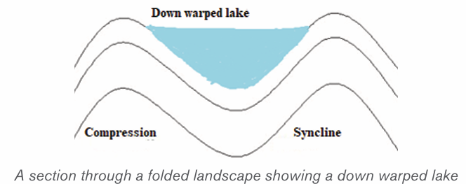
They are usually deep, elongated, and have steep sides. They are located on
the floor of a rift valley. Examples are Lakes Kivu in Rwanda, Turkana in Kenya,Tanganyika and Malawi in Tanzania.
B) Lakes produced by glacial erosion and glacial deposition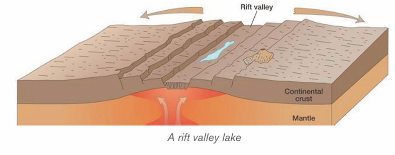
Cirque lake, also call a Tarn Lake is a Lake that forms in a glaciated highland.
Such lake occupies an armchair-like depression, called a cirque. During thawing
(melting of snow), water collects in circular depressions that were left behind
where large avalanches or boulders were uprooted by melt glaciers.
A cirque lake sometimes feeds a mountain river. Tarns occur on the sides ofMount Kenya like Teleki Tarn and on Mt Rwenzori for example Stanley Lake.
Trough Lake: This occupies an elongated hollow excavated by ice on the floor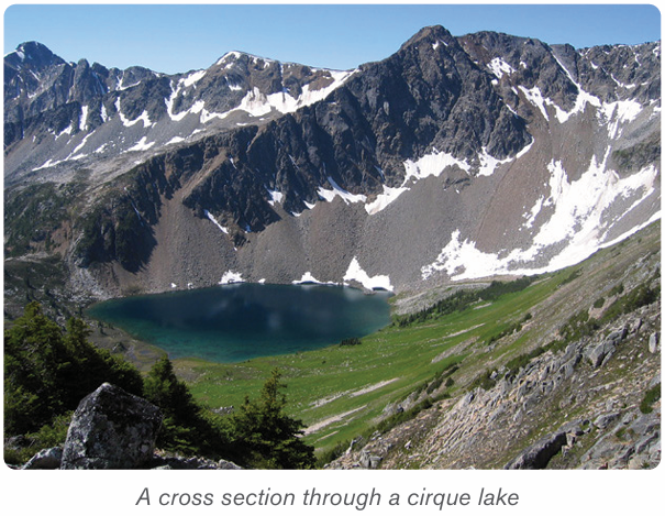
of U-shaped valley. It is sometimes called a ribbon lake. Lake Michaelson, in theGorges Valley, near to Mount Kenya, is a trough lake.
• Kettle Lakes: These are small lakes that are formed in depressions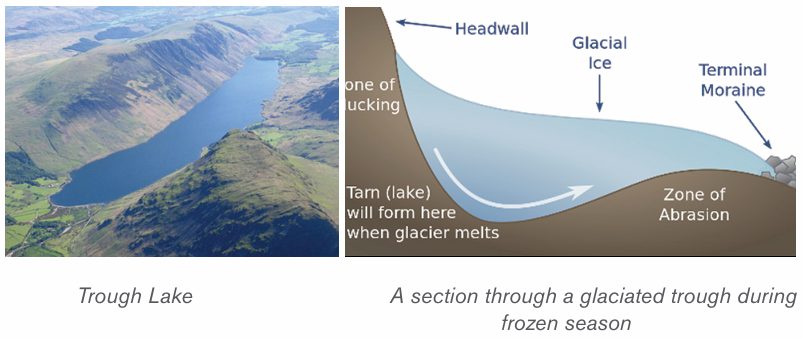
in glaciated lowlands. They are formed when melt water occupy
depressions called kettle holes.
• Moraine dammed lakes: These are lakes that form in glaciated
lowlands when a moraine dams the flow of melt waters in glaciatedlowlands.
C) Lakes produced by wind erosion
These are lakes that form in desert depressions left behind where large masses
of sand dunes and pebbles have been removed. Wind deflation sometimes
produces extensive depressions which reach down to the water-table in arid
deserts. The lakes of these depressions are not always true lakes-they may
be nothing more than muddy swamps. The Quattara depression, in Egypt, is a
good example.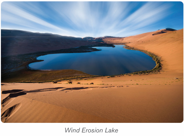
More permanent desert lakes develop when an aquifer becomes exposed.
These lakes are called oases. Some desert lakes dry up because of excessive
evaporation and all that remains is a lake bed of salt. This is called a playa or a
Salt Lake.
D) Lakes produced by river deposition
Ox-bow Lake: It is formed when a meander loop of a river on a flood plain iscut off from the main river. The river Galma, in Nigeria, has several ox-bow lakes.
Delta Lake: This Lake is formed by the deposition of alluvium by rivers turning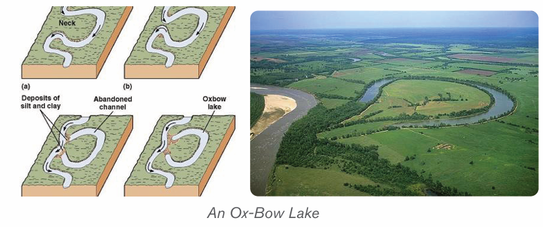
either a part of the sea into a lagoon, or part of a distributary into a lake. TheEtang de Vaccares is a delta lake. Delta lakes occur in the Nile Delta, in Egypt.

Flood plain Lake: A levée sometimes prevent water from returning to the river,
thus causing a lake to form. There are several lakes of this type on the RiverCongo.
Boulder Clay Lake: Some boulder clay deposits contain depressions which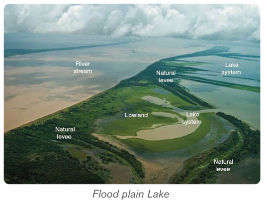
become the sites for lakes. There are lakes of this type in Northern Ireland.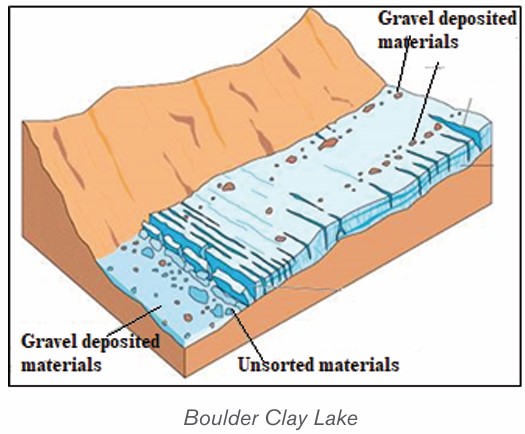
A. Lakes produced by marine deposition
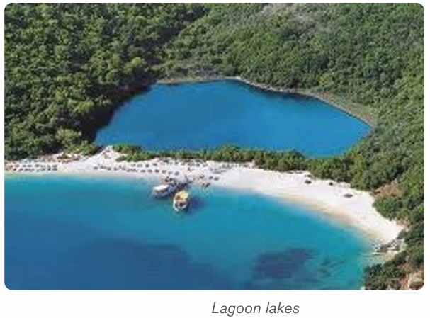
Lagoon: This is a lake formed by a sand bar or sand spit extending along a
coast and cutting off a coastal indentation hence forming a lagoon. Sometimesa barrier beach extends across the mouth of a river, producing a lagoon.
B. Lakes produced by volcanicity:
1. Crater lakes or caldera lakes are formed in volcanic craters and calderas,
which fill up with precipitation more rapidly than they empty via evaporation,
groundwater discharge or combination of both. Crater (small volcanic
depression) and Caldera (large volcanic basin) There are several caldera
lakes in Africa: Lake Shala, in Ethiopia, Lake Ngorongoro in Tanzania, Lake
Toba, in Sumatra (Indonesia) is also a caldera lake. In Rwanda, the CraterLakes are also found on Mountains Bushokoro, Muhabura and others.
2. Lava-dammed lake: A flow of lava may sometimes block the flow of a river
valley which causes a lake to form. The Sea of Galilee, in the Jordan valley,
was formed by lava damming the flow of river Matiandrano. The lava dammed
lakes in Rwanda are Lakes Burera and Ruhondo in Burera district of NorthernProvince.
C. Other types of lakes
– Solution Lake: This sometimes develops in a limestone area when
rainwater has dissolved the rocks to form a cave, and when the floor of
this cave is near to the base of the limestone. Lake Scutari, in Yugoslavia,
is a solution.
– Temporary Barrier Lake: Such a lake forms when an avalanche, or
scree fall, or landslide blocks a river valley. A lake of this type is only
temporary.
– Man-made lake: This is often called a reservoir. It is deliberately
formed by building a dam across a narrow, steep-sided section of
a river valley, usually a gorge, or constructing a wider depression or
water dam to trap rain water in a valley for the purpose of storing water
for irrigation, wet rice cultivation or for developing hydroelectricity or
both. Such lakes in Rwanda are Cyabayaga in Nyagatare District and
Rugeramigozi in Muhanga District.
– Lakes produced due to mass movement: Movement of debris
down slope due to the influence of gravity may block a river valley. They
may be landslides, mudflows, avalanches or rock slides.
– Lakes produced by alluvial deposits: These are lakes formed
because of back ponding by rivers. Such lakes form in depressions
within river valleys. Examples of such lakes are; Rweru, Ihema, Hago
Rwanyakizinga etc. along the valley of river Akagera.
8.4.3. Impact of lakes
The usefulness of lakes to human society are briefly described below.
• Source of fish: Lakes are habitats for different varieties of fish. This
has favoured the development of fishing and related industries.
• Source of minerals and natural gases: lakes such as Magadi in
Kenya, Natron in Tanzania and Katwe in Uganda are source of salt, Lake
Kivu in Rwanda contains natural gas.
• Tourism: Lakes provide beautiful sceneries and other activities which
attract tourists. This earns a country foreign exchange.
• Cheap transport: Lakes form cheap natural waterways for goods
and passengers.
•Source of power: Some lakes have been harnessed for the generation
of hydroelectric power. For example, Lakes Burera and Ruhondo
generate power on Ntaruka hydroelectric power plant.
• Source of useful water: Lakes are sources of water for domestic and
industrial uses.
• Source of drinking water for animals like cattle, sheep, goats, etc.
• Source of building materials: Some lakes are source of building
and construction materials such as sand, pebbles, small rocks, water
used in construction, etc.
• Regulating river flow: Some lakes help in controlling floods by
regulating the flow of rivers.
• Modification of climate: Lakes are important factors controlling the
climate of the surrounding areas because they provide the moisture.
The lakes also modify the climate of the adjacent areas.
• Source of rivers: Some lakes are sources of rivers. They act as
reservoirs and stores of water to rivers. For example, Lake Kivu is a
source of river Rusizi, Lake Muhazi is source of Nyabugogo River, etc.
8.4.4. Distribution of seas and Oceans
A) Distribution of Seas
A sea is a very large mass of saline water that occupies a very huge depression.
Seas occupy large basins on the continental margins. Lakes are smaller than
seas but seas are also smaller than oceans. Seas are of two types namely:
• Inland seas. These are shallow seas over part of a continent. They are
connected to oceans by straits
• Marginal Sea. This is a sea partially enclosed by islands, archipelagos,
or peninsulas, adjacent to or widely open to the open ocean at the
surface, and/or bounded by submarine ridges on the sea floor.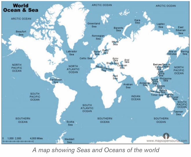
B) Distribution of oceans
An ocean is a large mass of saline water. Oceans occupy basins between
continents. There are five oceans in the world. These are as follows:
• Southern (Antarctic) Ocean: with an area of 20 million kilometers square
• Arctic Ocean: with an area of 14 million kilometers square
• Indian Ocean: with an area of 68.5 million kilometers square
• Atlantic Ocean: with an area of 76 million kilometers square• Pacific Ocean: with an area of 155 million kilometers square
Application activity 8.4
1. Draw a sketch map of Rwanda and on it indicate the types of Lakes.2. Explain their mode of formation.
Skills Lab
Water pollution is a result of human activities. Give advice on how to
prevent it.
End unit assessment
1. Some ocean currents originate from warm regions and others from
cold regions. Describe the relationship between ocean currents and
the atmospheric circulation.
2. Conduct your own research to describe the major ocean management
projects in the world.
3. Discuss the economic advantages of drainage in Rwanda, and in the world.
4. Explain the strategies to mitigate natural hazards associated withdrainage system.
REFERENCES
Afedrary, L. (2015). Soil erosion. Retrieved from https://www.monitor,co.ug/
Farming.
Bishop, V. a. (2001). Water Resources: Processes and Management. London:
Collins Publishers.
Buckle C. (1978). Landforms in Africa. London: Longman.
Bunnet R.B. (1973). General Geography in diagrams. Pearson Education
South Asie Pte Ltd.
Bunnet R.B. (1984). Physical geography in diagrams for Africa. Longman.
Bunnet R.B. (2010). Physical geography in diagrams for Africa. Kigali: Longman.
Bunnet, R. B. (2008). General Geography in Diagrams Longman. London:
PEARSON Longman.
Byamugisha, B. (2010). Physical Geography: A Systematic Study in Geomor
phology and Climatology for advanced level students. Kampala: Kabs Publishers Ltd.
Byamugisha, B. (2010). Sysematic Study in Geomorphology and Climatology
for Advanced level Students. Kampala.
Byizigiro, V., & Biryabarema. (2009). Soil erosion. Kigali: Rwanda Natural Science.
Christopherson, R. W. (2012). An Introduction to Phyisical Geography: Geo
systems. New Jersey: Pearson Prentice Hall.
Collins Buckle. (2007). Landforms and landscapes in Africa: AN introduction
to Geomorphology. Ednburgh: Pearson Education Limited.
Gabler, R. P. (2009). Physical Geography. Belmont: Brooks/Cole, Cengage
Learning.
Glencoe. (1999). Earth Science: Teacher Wraparound Edition. Westerville:
McGraw-Hill.
Henrie M.K. (2009). Principles of Physical Geography. Kampala: Compsolutions.
John Whitton. (1984). Dictionary of Physical geography. New York: Nwe York .
Kallie, S. (2017 , July 16). The Yellow River. Retrieved May 6, 2018, from
www.thoughtco: https://www.thoughtco.com/yellow-river-in-chinas-histo
ry-195222
Kichodo, H. M. (2009). Principles of Physical Geography: Advanced Level
Geography. Kampala: HMK.
Mcmaster, D. N. (2000). Mapreading for East Africa Longman. Edinburgh:
Longman.
Minns, W.J. (1984). A geography of Africa. Macmillan.
MonkHouse, F.J. (2008). Principles of physical Geography. London: Hodder
Education.
NAPA-RWANDA. (2006). National adaption programs of action to climate
change. Kigali: Ministry of lands, environment, forestry, water and mines.
Ndehedehe, C. E. (2017). Analysis of hydrological variability over the Volta
river basin using in-situ data and satellite observations. Journal of Hydrology:
Regional Studies, 88-110.
Nzabona A.C.N (1998). Physical Geography for Advanced level: Questions
and essay guides. Published in Kampala (U).
Safari Sibo et al. (2013). MK SENIOR 5 SECONDARY GEOGRAPHY STU
DENTS BOOKS. Kampala: MK.
S-Cool.CO.UK. (n.d.). Elluviation and illuviation processes of weathering. Re
trieved from https://www.google.rw/search.
SENTAMU, S. A. (2011). Statistics and geography of the world. Kampala.
Strahler, A. (2011). Introducing Physical Geography, 5th Ed. Boston: John
Willey and & Sons Inc.
Strahler, A. a. (2008). Visualizing Physical Geography. Hoboken: John Wiley &
Sons.
UK ESSAYS. (March, 2015). The importance of the Nile River. Environmental
science essay.
UNICEF. (2008). Rwanda earthquakes: Unicef responds to immediate needs
of children and women affected by earthquakes. Kigali: Unicef.
Water Technology. (1983, January 1). Retrieved May 6, 2018, from www.
water-technology.net: https://www.water-technology.net/projects/aswan-high
dam-nile-sudan-egypt/
Water-resources. (2010, Jan 1). https://www.nextgurukul.in/wiki/. Retrieved
April 23, 2018, from Waugh, D. (2009). Geography: An Integrated Approach.
London: Nelson Thornes.
Whitton, J. B. (1984). Dictionary of physical geography. New York: PEGUIN
BOOKS.
Whittow J. (1984). Dictionary of physical geography. Penguin books.
Wu, A. ( 2015, September 21). The Geography of the Yellow River. Retrieved
May 6, 2018, from chinahighlights: https://www.chinahighlights.com/yellowriv
er/geography.htm
Active continental margins: Continental margins that coincide with
tectonically active plate. Asthenosphere: The plastic like, soft layer below the
lithosphere in earth’s mantle, beneath the rigid lithosphere.
Adaptation measures for climate change: Measures and strategies taken
to adapt to climate change and its variability.
Aerosols: Suspended Particulate Matter (SPM) in the atmosphere including
solid particles of varying sizes and liquid droplets are collectively called aerosols
which include: ploughed soil cover, deserts, rocks, salt particles from seas and
oceans; meteoric particles, organic matter: bacteria, seeds, spores and pollen.
Andesite: Extrusive igneous rock of diorite composition, dominated by
plagioclase feldspar; the extrusive equivalent of diorite.
Antecedent drainage: A part of a river slope and the surrounding area uplifts
but the river maintains its original slope.
Basalt: Extrusive igneous rock of gabbro composition; occurs as lava.
Bleach coral reefs: These are white coral reefs after expelling the algae
(zooxanthellae)
Clay minerals: class of minerals produced by alteration of silicate minerals,
having plastic properties when moist.
Clay: sediment particles smaller than 0.004 mm in diameter.
Climate change mitigation: Involves reductions in human (anthropogenic)
emissions of greenhouse gases.
Climate variability: It is variations of atmospheric conditions at a specific
location or globally in short term.
Coal: Rock consisting of hydrocarbon compounds, formed of compacted,
lithified, and altered accumulations of plant remains (peat).
Collision: Process where two continental crust collide and, as neither can sink,
are forced up into fold mountains.
Compression (tectonic): Squeezing together, as horizontal compression of
crustal layers by tectonic processes.
Conglomerate: A sedimentary rock composed of pebbles in a matrix of finer
rock particles.
Continental crust: Crust of the continents, of felsic composition in the upper
part; thicker and less dense than oceanic crust.
Continental drift: Hypothesis proposed by Alfred Wegener, which states that
continents have moved horizontally around the globe, over time, to reach their
current location.
Continental lithosphere: Lithosphere bearing continental crust of felsic
igneous rock.
Continental margins tectonic: Marginal belt of continental crust and
lithosphere that is in contact with oceanic crust and lithosphere, with or without
an active plate boundary being present at the contact.
Continental margins: A zone which combines both the continental shelf and
the continental slope and is distinct from the deep-sea floor.
Control Gate: A facility used to control over the water travelling in penstock.
Convection current: The driving forces of plate tectonics in which hot, plastic
like material from the mantle rises to the lithosphere, moves horizontally, cools,
and sinks back to the mantle.
Convergent boundary: In plate tectonics, the boundary between two plates
that are converging, or moving toward each other.
Coral reef: Skeletons of very small sea creatures.
Coral: A marine polyp capable of secreting calcium carbonate to build an
external skeleton.
Coriolis force: Deflecting motion caused by the rotation of the earth which
makes a body or current moving across its surface to be deflected to the right
in the north hemisphere, and to the left in the south hemisphere.
Crane: A type of machine, generally equipped with a hoist rope, wire ropes or
chains, and sheaves that is used both to lift and lower the gates which regulate
intake gates or water flow from reservoir through the tunnel of a dam.
Crust: Outermost solid layer of the earth, composed largely of silicate materials
Dam: a barrier constructed across a river to hold back water and raise its level,
forming a reservoir used to generate electricity or for domestic, irrigation or
industrial water supply. Some dams are built also to preventing the flow of water
or loose solid materials (such as soil or snow).
Deposition: The laying down of material that has accumulated after having
been eroded and transported.
Desertification: Land degradation in which a relatively dry land region
becomes increasingly arid, typically losing its water bodies as well as vegetation
and wildlife.
Development: The process in which some economic sectors or activities
(e.g. agriculture, industry, technology, etc.) grow or change and become more
advanced
Diorite: Intrusive igneous rock consisting dominantly of plagioclase feldspar
and pyroxene; a felsic igneous rock.
Divergent boundary: In plate tectonics, the boundary between two plates that
are diverging, or moving away from each other.
Dolomite: Carbonate mineral or sedimentary rock having the composition
calcium magnesium carbonate.
Drainage pattern: A plan made by a river and its tributaries along the landform
Dredging: Clear the bed of a harbour, river, or other area of water by scooping
out mud, weeds, and rubbish with a dredge”the dredging and deepening of the
canal”.
Dry farming: This is also called Dry land Farming. It is the cultivation of crops
without irrigation in regions of limited moisture, typically less than 20 inches (50
centimetres) of precipitation annually.
Earthquake: A trembling or shaking of the ground produced by the passage
of seismic waves.
Ecosystem: Total living things in an area including ways they interact each
other in the environment
Effluents: Liquid waste or sewage discharged into a river or the sea from
industries.
Eustasy: any uniformly global change of sea level that may reflect a change in
the quantity of water in the ocean, or a change in the shape and capacity of the
ocean basins
Extinction: the state or process of being or becoming extinct /disappearance,
vanishing.
Extrusive igneous rock: Rock produced by the solidification of lava or ejected
fragments of igneous rock (tephra).
Feldspar: Group of silicate minerals consisting of silicate of aluminum and
one or more of the metals potassium sodium, or calcium (See also plagioclase
feldspar, potash feldspar)
Felsic igneous rock: Igneous rock dominantly composed of felsic minerals.
Felsic minerals (felsic mineral group): Quartz and feldspars treated as a
mineral group of light color and relatively low density. (See also mafic minerals.)
Flood control: Methods are used to reduce or prevent the detrimental effects
of flood waters.
Gem: Also called Game stone is a valuable mineral highly prized because it is
rare and beautiful.
Gentle slopes: These are areas located in rolling countryside where slope is
between 5 and 15% and the pattern of rainfall distribution regularly results in
erosion events. They are very common in Mediterranean countries
Glacier: It is a large mass of ice in motion.
Gondwanaland: A supercontinent of the Permian period including much of the
regions that are now South America, Africa, Antarctica, Australia, New Zealand,
Madagascar, and peninsular India.
Granite: Intrusive igneous rock consisting largely of quartz, potash feldspar
and plagioclase feldspar with minor amounts of biotite and hornblende; a felsic
igneous rock
Gravity: The force by which objects are attracted to one another because of
their mass on the earth surface.
Greenhouse effect: Is process in which atmosphere of earth trap some of
heat coming from sun, making Earth warm than usual.
Holomorphic soils: These are intrazonal soils which have developed in areas
where salts have accumulated at or near the surface.
Hurricane: A type of tropical cyclone with sustained winds that exceed 74 mph
and accompanied by rain, thunder and lightning
Hydromorphic soils: These are intrazonal soils developed in presence of
excess water.
Ice cap: An area of permanent ice.
Intrusive igneous rock: Igneous rock body produced by solidification of
magma beneath the surface, surrounded by preexisting rock.
Laurasia: A supercontinent of the Permian period, including much of the region
that is now North America and western Eurasia.
Lava: Magma emerging on the Earth’s solid surface, exposed to air or water.
Levee: Also called embankment or flood bank or stop bank is an elongated
naturally occurring ridge. It is usually earthen and often parallel to the course of
a river in its floodplain or along low-lying coastlines.
Lithosphere: The rigid, outermost rock layer of the earth, about 100 km thick,
composed of the crust and part of the mantle, lying above the asthenosphere.
Mafic igneous rock: Igneous rock dominantly composed of mafic minerals.
Mafic minerals (mafic mineral group): Minerals, largely silicate minerals, rich in
magnesium and iron, dark in color, and of relatively greater density.
Magnetometer: A sensitive instrument that records magnetic data and is used
to study earth’s magnetic field.
Marble: Variety of metamorphic rock derived from limestone or dolomite by
recrystallization under pressure.
Metamorphic rock: Rock altered in physical structure and/or chemical
(mineral) composition by action of heat, pressure, shearing stress, or infusion of
elements, all taking place at substantial depth beneath the surface.
Mid-oceanic ridge: One of three major divisions of the ocean basins, being
the central belt of submarine mountain topography with a characteristic axial rift.
Mineral: Is a naturally occurring chemical compound, usually of crystalline form
and abiogenic in origin (not produced by life processes). A mineral has one
specific chemical composition, whereas a rock can be an aggregate of different
minerals or mineraloids. The study of minerals is called mineralogy
Oasis: A moist fertile place in the desert usually surrounding a well or spring
Oceanic crust: Crust of basaltic composition beneath the ocean floors,
capping oceanic lithosphere.
Oceanic lithosphere: Lithosphere bearing oceanic crust.
Oceanic trench: Narrow, deep depression in the seafloor representing the line
of sub-duction of an oceanic lithospheric.
Ore: A mineral containing a useful substance, such as metal, that can be mined
at a profit.
Ox-bow Lake: A horse shoe shaped lake form from a meander that is cut off
and abandoned by the main river.
Pangaea (pan JEE uh): The name Alfred Wegener gave to the single large
landmass, made up of all continents, that he believed existed before it broke
apart to form the present continents.
Parent rock: It is the material (rock) from which soil is formed.
Passive continental margin: Continental margin lacking active plate
boundaries at the contact of continental crust with oceanic crust.
Peridotite: Igneous rock consisting largely of olivine and pyroxene; an ultramafic
igneous rock occurring as a pluton, also thought to compose much of the upper
mantle.
Petrology is the branch of geology that studies rocks and the conditions under
which they form. Petrology has three subdivisions: igneous, metamorphic, and
sedimentary petrology
Plate tectonics: Theory that earth’s crust and upper mantle (lithosphere) are
broken into sections, called plates that slowly move around on the mantle.
Prevailing wind: The direction of wind most frequently observed during a
given period.
Pyroclastic materials: The fragmental rock products ejected by a volcanic
explosion having been broken by fire.
Quartzite: Metamorphic rock consisting largely of the mineral quartz.
Reservoir: Usually means an artificial lake, storage pond or impoundment
created using a dam or lock to store water. Reservoirs can be created by
controlling a stream that drains an existing body of water.
Rhyolite: Extrusive igneous rock of granite composition; it occurs as lava or
tephra.
Ridge: An elongated area of relatively high altitude bordered by an increasingly
low altitude side.
River capture: The diversion of waters of a weaker river into the system of a
stronger river.
River profile: A section of a river from its source to its mouth.
River rejuvenation: The renewed erosive activity of a river.
River terraces: A portion of the former flood plain of a river now, abandoned
and left at a higher level as the stream down cuts its sides
River: A mass of flowing water from a known source to a known destination
Rock or stone is a natural substance, a solid aggregate of one or more minerals
or mineraloids.
Run off: The proportion of rain water that reaches streams either by flowing
over ground.
Sandstone: Sedimentary rock consisting largely of mineral particles of sand
size.
Schist: Foliated metamorphic rock in which mica flakes are typically found
oriented parallel with foliation surfaces.
Sea: A body of salt water smaller than an ocean and generally in proximity to
continent.
Seafloor spreading: The theory that magma from earth’s mantle rises to the
surface at mid-ocean ridges and cools to form new seafloor, which new magma
pushes away from the ridge.
Sediment: Finely divided mineral matter and organic matter derived directly or
indirectly from pre-existing rock and from life processes.)
Sedimentary rock: Rock formed from accumulation of sediment.
Shale: Fissile, sedimentary rock of mud or clay composition, showing lamination.
Siltation: It is the pollution of water suspended sediments dominated by clay
and silt. Siltation is most often caused by soil erosion.
Slate: Compact, fine-grained variety of metamorphic rock, derived from shale,
showing well-developed cleavage.
Slope: It is an inclined surface.
Snow: precipitation in form of white ice crystals
Soil: It is the thin layer of unconsolidated material covering the surface of the
earth that is able to support plant life.
Spreading plate boundary: Lithospheric plate boundary along which two
plates of oceanic lithosphere are undergoing separation, while at the same time,
new lithosphere is being formed by accretion.
Steric effect: When some regions experienced sea level rise while others
experienced a fall, often with rates that are several times to the global mean rate.
Subduction zone: In plate tectonics, the area where an ocean-floor plate
collides with a continental plate and the denser ocean plate sinks under the
less dense continental plate. It is a boundary between two crustal plates along
which subduction is occurring and lithosphere is being consumed.
Subduction: Descent of the down bent edge of a lithospheric plate into the
asthenosphere so as to pass beneath the edge of the adjoining plate.
Superimposed drainage: A drainage pattern which exhibits a discordant
drainage: with the underlying rock structure because it is originally developed
on a cover of rocks that have now disappeared owing to denudation.
Surface run off: The proportion of rain water that reaches streams either by
flowing over ground or by seeping through the soil.
Syzygy: A term given to the situation when the earth, moon and sun are in
conjunction or opposition. i.e. when they are all in a straight line.
Tectonic: Pertaining to the internal forces which deform the earth’s crust
thereby affecting the pattern of sedimentation or resultant landforms.
Terra Rosa: It is a reddish clay-loam soil developed under a warm seasonally
dry climate on limestone.
Tethys Sea: inland sea from where the two blocks of landmasses separated
Tidal currents: A horizontal movement of sea water in response to the rise and
fall of the sea or ocean.
Tide: The regular rise and fall of water level in the world’s oceans, resulting
from the gravitational attraction that is exerted upon the Earth by the sun and
the moon.
Tornado: A violently rotating column of air that extends from a thunderstorm to
the ground and is often - although not always - visible as a funnel cloud.
Transform fault: In plate tectonics, a boundary between two plates that are
sliding horizontally past one another.
Transform plate boundary: Lithospheric plate boundary along which two
plates are in contact on a transform fault; the relative motion is that of a strike
slip fault.
Tsunami: Train of sea waves set off by an earthquake (or another seafloor
disturbance).
Tuffaceous limestone: A sedimentary limestone that contains up to fifty
percent volcanic tuff these are ash and cinders.
Ultramafic igneous rock: Igneous rock composed almost entirely of mafic
minerals, usually olivine or pyroxene group.
Visibility: The longest distance that prominent object can be seen.
Volcanism: General term for volcano building and related forms of extrusive
igneous activity.
Volcano: Conical, circular structure built by accumulation of lava flows and tephra.
Wave: Is a deformation of water surface in the form of oscillatory movement
which manifests its self by an alternating rise and fall of that surface.
Windblown area: This is an area which experiences a lot of wind as an agentof erosion.