Topic outline
General
- Geography SSE Y3 SB File Uploaded 2/11/21, 16:09
- Geography SSE Y3 TG File Uploaded 2/11/21, 16:08
UNIT 1: INTERPRETATION OF PHOTOGRAPHS AND VIDEO IMAGES
Key Unit competence:
By the end of this unit, I should be able to interpret photographs, video andimages.
Introductory activity
In the previous units, it was shown that maps are very important tools to
indicate and to describe physical and human features. Identify and describe
other techniques used in geography to locate and display physical andhuman features.
1.1. Definition and types of photographs
Learning activity 1.1Describe the difference between the two photographs provided below:
1.1.1. Definition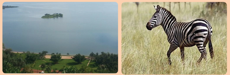
A photograph is a picture of an object or environment taken by a camera at
a particular time in a given place. Photographs are techniques of recording
geographical information. They enhance the understanding of reality. However,
when a photograph is taken, some parts of the object or environment are seen
while others may not appear clearly. A hidden ground or area which cannot beseen by a camera when a photograph is taken is called a dead ground.
1.1.2. Major types of photographs
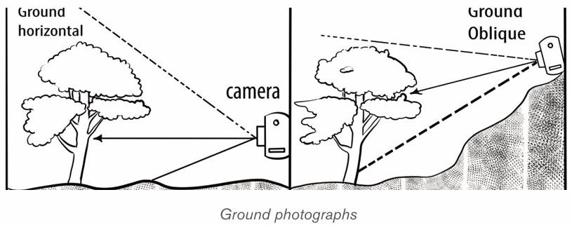
There are two major types of photographs: Terrestrial / close or ground
photographs and Aerial photographs.1) Ground Photographs
Also called terrestrial or close photographs, ground photographs are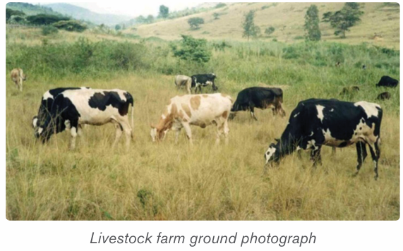
photographs taken from the ground level. They record targets exactly what a
person would see if he or she was standing on the ground level. A ground
photograph gives a horizontal view, great details of the landscape and covers asmall area.
There are two types of ground photographs:
i) Ground horizontal photograph: This is a photograph taken when a
camera is held horizontally to the ground.
ii) Ground oblique photograph: This is a photograph taken when thecamera is titled at an angle facing the ground.
2) Aerial Photographs
Aerial photographs are images taken from aerial station such as aircrafts,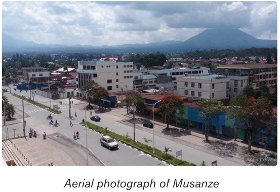
satellites and other flying objects. They cover a wide area where features are
greatly reduced. They show the top of the object and do not view objects in a
perfect horizontal perspective.
There are two categories of aerial photographs:
i) Vertical aerial photographs are images taken when the camera is
directly located above or overheading the target objects, or when it isperpendicular to the ground.
ii) Oblique aerial photographs: These are photographs taken when the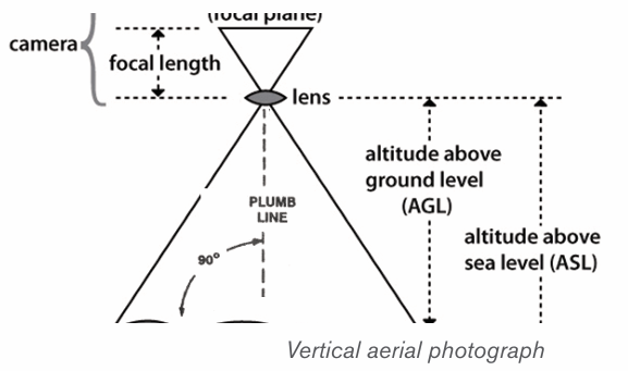
camera is titled at an angle below 90 degrees.
Application activity 1.1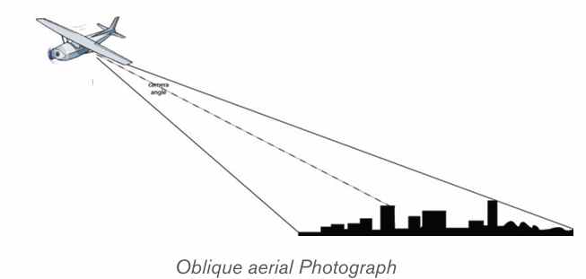
Identify the types of the photographs A and B below and describe them
1.2. Sections of a photograph and interpretation of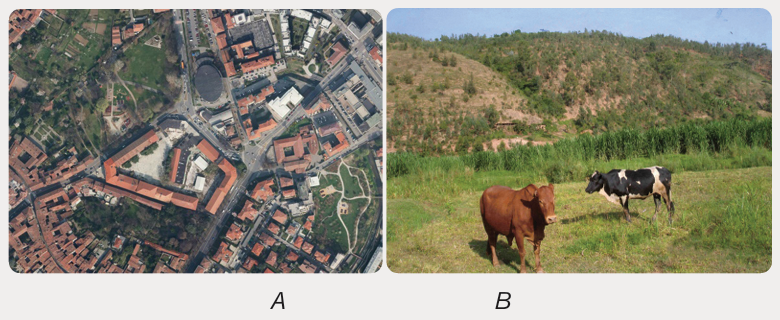
physical and human aspects
Learning activity 1.2
Observe the photograph below and answer the following questions:
1) Identify the physical and human features shown on the below
photograph.
2) Indicate the respective parts where these features are found in thebelow photograph.
1.2.1. Sections of a photograph
From a horizontal perspective, photographs have three parts described below:
• The foreground: It is the part of the photograph located nearest to
the camera.
• The middle ground: It is the central part of the photograph.
• The back ground: It is the farthest part of the photograph that includes
the horizon.
From a vertical perspective, photographs are also divided in three parts: left,
centre and right.
Combining both horizontal and vertical perspectives, the photographs can beput into the following categories:
1.2.2. Interpretation of physical and human aspects on
photographs and video images
Physical and human aspects on photographs and video images can beinterpreted as follows:
A. Interpretation of physical aspects
i) Climate: Climate in a photograph is indicated by rainfall and temperature.
Heavy rainfall can be observed by presence of dense forests and crops
like sugar cane, rice and tea while high temperature may be observed by
the presence of poor vegetation, people wearing light clothes etc.
ii) Relief: The landforms depicted on a photograph include mountains,
hills, valleys, escarpments, plateaus and plains. A hilly or mountainous
landscape is indicated by the presence of steep slopes, presence of
terraces, snow and glaciers on the top. Plateaus and plains are identified
by a uniformly flat land with sloping edges and pools of water or irrigated
land. Wide valleys with meanders and flood plains also suggest thepresence of plain land.
Relief on vertical aerial photographs can be interpreted by observing the
following:
• Flat areas can be identifiable by the presence of meandering rivers,
straight roads and gentle bends.
• Plateaus can be indicated by presence of flat topped hills.
iii) Vegetation: This is the plant life that covers the earth surface; it is both
natural and artificial. When describing vegetation on a photograph, the
aspects to consider are the type of vegetation whether grassland, scrub
or thicket; the tree species such as baobab, acacia, eucalyptus; the
density of the vegetation whether trees are close together or scattered;
and the nature of the vegetation whether human made or natural.
iv) Drainage: Drainage is shown by the presence of water bodies on a
photograph, such as streams, rivers, lakes, swamps, seas, and oceans.
Others are man-made water features like wells, ponds, valley dams and
boreholes. In photographs, drainage is interpreted in the following ways:
• Rivers appear with meandering channels with swampy vegetation along
them.
• Swamps appear with luxuriant vegetation dominated by papyrus reeds.
v) Soils: The types of soils can be identified by observing the types of
crops grown there because there are crops that grow well in specific
types of soils, for example, tea and coffee grow well in fertile volcanicsoils. Where erosion took place, the soils are exposed.
B. Interpretation of human aspects
Photographs and video images can be very useful in the interpretation of human
activities such as:
i) Forestry: A forest is evidenced by the presence of both artificial and
natural forests.
ii) Agriculture: Agricultural activities can be observed by the presence of
food crops and cash crops as well as animals like cattle both exotic and
traditional breeds.
iii) Transport and communication: Both transport and communication
networks are evidenced by presence of motor vehicles, bicycles, roads,
ships, airports, and communication facilities such as telephone lines and
masts.
iv) Mining: This is shown by Open pits, people undertaking mining or a
mineral processing plant show that there is mining taking place in that
area.
v) Industry: Industrialization is shown by the presence of industries emitting
smoke from huge chimneys.
vi) Trade or commerce: the commerce is evidenced by trading centers
with congested buildings and at times presence of markets.
vii) Settlement: It is evidenced by the presence of houses in differentpatterns.
Application activity 1.2
Observe the photograph below and describe the physical and humanaspects represented on it.
1.3. Relationship between physical and human aspects on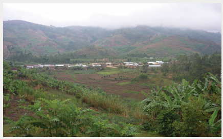
photographs and video images
Learning activity 1.3
Describe the relationship between physical and human features representedon the photograph below:
Photograph showing physical features (down-left) and human
features (up-right): the arrow indicates the position of a river whichdrains the valley that appears on the photograph.
Some photographs and video images help in illustrating the relationship
between human and physical aspects. Basing on the figure provided above, the
relationship between human and physical aspects can be explained as follows:
i) Relief and transport: Transport routes occur on gentle slopes and
avoid steep slopes and valleys since it is very expensive to construct
roads in hilly areas.
ii) Relief and agriculture: On steep slopes, less agriculture takes place
while on gentle slopes most agricultural practices are observed. The low
lands are usually reserved for growing of vegetables, sugar cane, rice,
and other crops that need enough water.
iii) Relief and settlement: Settlements are commonly found in gentle
slopes and are few in steep slopes and valleys because of the problem
of severe soil erosion and flooding in valleys.
iv) Drainage patterns and settlement: Settlement occurs in well
drained areas and avoids lake shores or river banks because of floods
and associated problems.
v) Drainage and transport: Transport routes are usually found in well
drained areas. For example, roads cannot be constructed in swampy
areas due to excessive water. Water transport occurs on water bodieslike rivers, lakes, oceans and seas.
Application activity 1.3
Observe the photograph below and describe how physical features haveinfluenced human activities in the area.
Skills Lab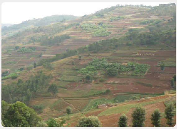
With help of the knowledge, skills, attitudes and values acquired in this unit,
suggest ways of conserving the physical features and promoting economicactivities in your school environment for sustainable development.
End unit assessmentStudy the photograph provided below and answer the following questions:
1) Identify the economic activities taking place and describe their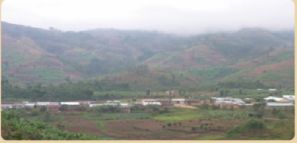
importance to the people living in the area.
2) Suggest ways of conserving the area in the background of the
photograph for environmental sustainability.
3) Identify the human features which are predominant in the foregroundof the above photograph
UNIT 2 :THE ORIGIN AND DISTRIBUTION OF THE CONTINENTS
Key Unit competence:
By the end of this unit, I should be able to discuss theories of the origin and
the distribution of continents.
Introductory activity
Observe carefully the maps provided below and answer the following
questions: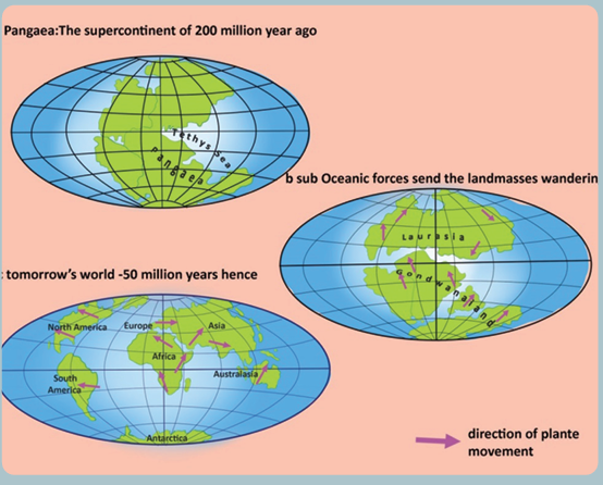
1) How many oceans do you find on map a
2) How many continents do you see on map b
3) How many continents do you see on map c
4) Explain the processes which led to the separation of the unique initial
landmass into various continents as they appear today.
2.1. Concept and theories of continental drift
Learning activity 2.1
• Make research using books and internet to explain the theory of
Alfred Wegener on the continental drift.
2.1.1. Concept of continental drift
The term continental drift refers to the study of causes and consequences of
the distribution of continents and ocean basins. It is defined as a slow movement
of the Earth’s continents towards and away from each other. The differential
movement of the outer shell resulted into fragmentation by rifting, followed by
drifting apart of individual masses of the broken outer shell.
2.1. 2. Theories of the origin and distribution of the
continents and ocean basins
There are several theories of continental drift that were developed at the
beginning of the 20th century. The following are the four main theories of
continental drift: Alfred Lothar Wegener’s theory; Maurice Ewing’s theory; Harry
Hammond Hess’ theory and Frank Taylor’s theory.
The theory of the origin and distribution of the continents and ocean
basins according to Alfred Wegener
According to Wegener’s theory, there was a breakup of the single super
continent block called Pangaea “pan JEE uh”, which means “all land” into
multiple continents, as they appear today, that moved apart in a process called
continental drift. That movement took place about 200 million years ago. The
map provided below fits together the continents whose breaking up resulted in
today’s continents.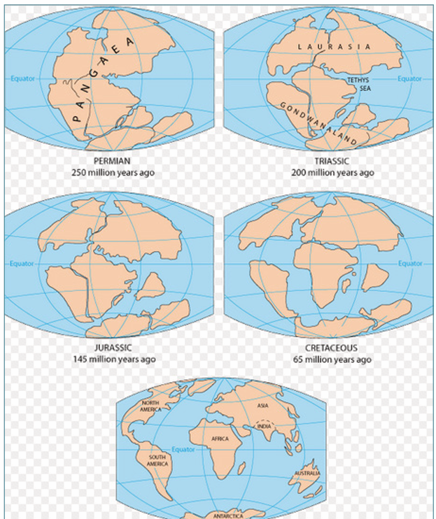
The break-up of Pangaea and periods of disintegration
The theory of continental drift traces the origin and distribution of continents
through five major steps:
i) The supercontinent Pangaea was surrounded by an extensive water
mass called the ‘Panthalassa’ (Pan means all and Thalassa means
oceans) or the primeval Pacific Ocean. During the Carboniferous period
(about 250 million years ago), the South Pole was near Natal (South
African coast) and the North Pole was in the Pacific Ocean.
ii) In about 200 million years, Pangaea broke up to form Laurasia (North
America, Greenland, and all of Eurasia north of Indian subcontinent),
and Gondwanaland (South America, Africa, Madagascar, India, Arabia,
Malaysia, East Indies, Australia, and Antarctica). These two blocks were
separated by a long shallow inland sea called Tethys Sea.
iii) In about 145 million years ago, the drifting of the southern landmasses
continued. India drifted northwards.
iv) In about 65 million years ago, Australia began to separate from Antarctica.
v) The present shapes and relative positions of the continents are the result
of fragmentation of Laurasia and Gondwanaland by rifting and drifting
apart of the broken landmasses following the formations of oceans and
seas (see figure above). South America separated from Africa, North
America separated from Europe, while Antarctica, Australia, India and
Madagascar formed a single unit with South America.
However, Wegener’s theory was initially criticized because he could not explain
how solid continents have changed their positions. His theory has been revived
by other researchers after discovering new evidences.
Application activity 2.1
1) Explain the concept of continental drift
2) Explain why Taylor’s theory on the origin and distribution of the
continents and ocean basins was initially criticized.
2.2. Evidences of continental drift
Learning activity 2.2
Observe the map provided below and answer the following questions:
1) Describe the edges of the continents.
2) What suggests the distribution of the same animal and vegetation
species over the different continents?
Many evidences of continental drift exist, but they can be summarized
in four major categories:
i) Geological evidence
A good fit of edges of continents and similar rock structures are found on
different continents. For example:
• East coast of South America and the Western Coast of Africa have
good visual fits, both at the surface (1000 m) and depth (2000 m).
• Both Africa and South America are composed of rocks of varying ages
and there is a convincing boundary joint across the two continents
between Accra and Sao Louis in Brazil and, dividing Pan-African rocks
and Elaurean rocks. This evidence constitutes what is commonly known
as “matching geology”
• Parts of Appalachian Mountains of the United States of America are
similar to those found in Greenland and Western Europe;
• The fact that rock particles have magnetic properties allowed
geophysicists to reconstruct the position of the poles in past times and
also the probable climatic lay belts of the past. From this, it appears
that Southern Africa and South America lay within the Arctic circle of
Permian and carboniferous times and that during the Triassic period,
the continents had moved some 40° closer to the Equator.
ii) Biological evidence
There is similarity in the fossils and vegetation remains found on the eastern
coast of South America and the Western coast of Africa. For example;
• Mesosaurus was small reptile living in Permian time (280 million of years
before present); its remains have been found only in South Africa and
Brazil.
• Remains of Glossopteris, a plant which existed when coal was being
formed has only been located in India and Antarctica. These animals and
plants could not have swum across oceans if continents were separated
by water bodies, so continents must have been close together for them to
occur on different continents which probably had a similar climate.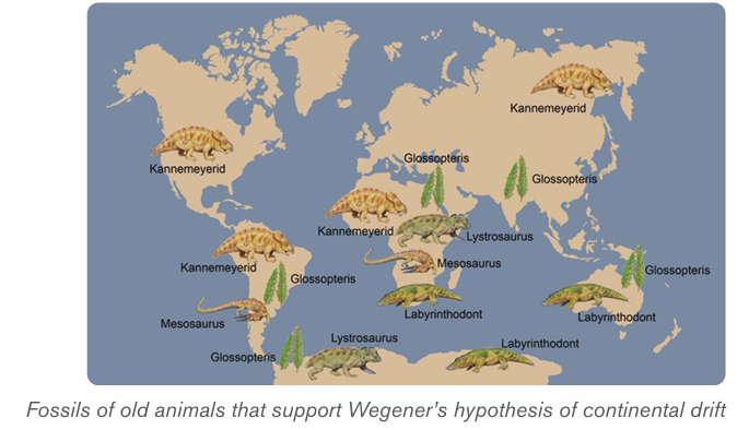
iii) Climatic evidence
Coal formed under warm and wet conditions was found beneath the Atlantic
ice-cap, and evidence of carboniferous glaciation had been noted in tropical
and central India. For example;
• Coal could not have been formed in Britain with its present climate.
• Peninsular India, Australia and Antarctica further prove the unification
of all landmasses in one landmass (Pangaea) during carboniferous period.
• Groves curved on rocks by glaciers in the southern parts of landmasses
forming Gondwanaland shown by arrows on the figure below provided
evidence for continental drift.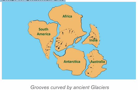
iv) Geodetic evidence
Geodetic evidence has revealed that Greenland is drifting westward at the rate of
20 cm per year. This is one of the scientific evidences arising from measurement
and representation of the earth that confirm the spread of the sea floor.
Application activity 2.2
1) Describe the rocks at the edge of the continents and show how all
continents formed a unique block.
2) Using some examples, compare the fossils of animal species and
vegetation species found on different continents by showing how
they indicate the continental drift.
2.3. Effects of continental drift on the evolution of physical
features
Learning activity 2.3
Make a research and describe at least four major effects of continental drift.
The continental drift has had many effects on the evolution of physical features
but the most important are the following:
• Pangaea split apart into a southern landmass, Gondwanaland and
the northern landmass called Laurasia; later the two super continents
split again into land masses that look like present day continents.
• Continental drift has also affected the earth’s climate. The climate of
different parts of the world has changes throughout the year;
• Continental drift has affected the evolution of animals. The rearrangement
and displacement of huge landmasses has helped create the diversity
which we see present in modern day animals.
• Collision of earth crusts. The collision of the Indian subcontinent and
Asian continent created the Himalayan mountain range, home to the
world’s highest mountain peaks.
• Formation of rift valleys. Rift valleys are sites where a continental
landmass is ripping itself apart. Africa, for example, will eventually split
along the western Great Rift Valley system.
• Continental drift is the major cause of earthquakes, volcanoes, oceanic
trenches, mountain range formation, and other geologic phenomenon
which created the new landscapes on the earth’s surface;
Application activity 2.3
Explain the effects of continental drift on the evolution of physical landscape
of the earth.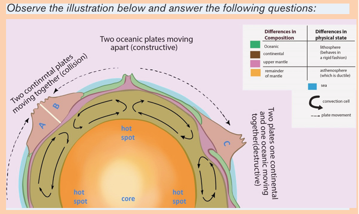
1) Identify the types of crust found on the map
2) Describe the difference between lithosphere and asthenosphere
3) Differentiate collision, constructive, and destructive processes
4) Determine the position of plate movements
5) Explain how convection cells cause the movement of plates
2.4.1. The concept of plate tectonics
The concept suggests that earth’s crust and upper mantle (lithosphere) are
broken into sections, called plates that slowly move on the mantle.
The word tectonic comes from the Greek word ‘tektonikos’ meaning building
or construction; this means how the earth crust is constructed. Therefore, plate
tectonics refers to the deformation of the earth’s crust, because of internal
forces, which can form various structures in the lithosphere.
The plate size can vary greatly, from a few hundred to thousands of kilometers
across. Plates are moved by the energy originating from the earth interior. This
energy is a result of convection currents which form convection cells. Tectonic
plates are irregularly shaped slabs of solid rocks, generally presenting two
types: Continental crust and Oceanic crust, as shown on the figure below.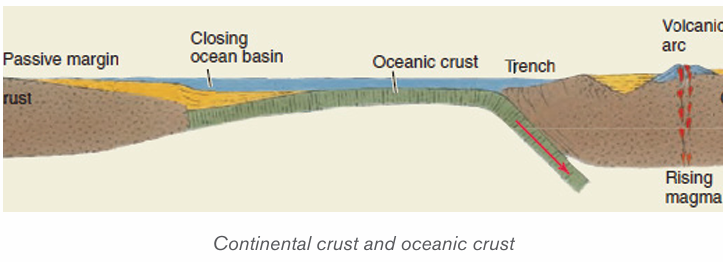
Tectonic processes include tension when plates diverge and compression
when plates converge. These processes result in deformation of the earth crust.
Tension causes fracturing and faulting of the crust while compression produces
folds and over thrust faults.
2.4.2. Types of Plate Tectonics
There are two types of plate tectonics: continental plate and oceanic plate.
i) Continental crust is composed of older, lighter rock of granitic type:
Silicon and Aluminum (SIAL).
ii) Oceanic crust consists of much younger, denser rock of basaltic
composition: Silicon and Magnesium (SIMA). The major differences
between the two types of plates are summarized in the table below:
2.4.3. Boundaries and movement of tectonic plates
i) Tectonic Plate boundaries
Boundaries of plate tectonic include the subduction zone, the mid-ocean ridge
and the transform boundary.
• Divergent boundary (Mid-ocean ridge): It is an underwater
mountain range which is formed when forces within earth spread the
seafloor apart. It is created when convection currents rise in the mantle
beneath where two tectonic plates meet at a divergent boundary, thus
forming the oceanic ridge.
• Transform boundary (Transform fault): It is a boundary which exists
between two plates that are sliding horizontally past one another, thus
forming the transform faults (see the figure below).
• Convergent boundary (Subduction zone): This is the area where
an ocean-floor plate collides with a continental plate and the denser
oceanic plate sinks under the less dense continental plate, thus forming
the oceanic trench.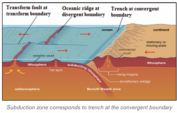
i) Tectonic plate movements
Plate movements include convergence, divergence and way past movement
along the transform fault.
• Convergence is a movement whereby two crustal plates are colliding
or one subsiding beneath the other. The margin where this process
occurs is known as a destructive plate boundary. This boundary is a
region of active deformation.
• Divergence is a movement whereby two crustal plates are moving away
from each other. The margin where this process occurs is known as a
constructive plate boundary. It initially produces rifts which eventually
become rift valleys.
• Way past is plates’ movement predominantly horizontal, where crust
is neither produced nor destroyed as the plates slide horizontally past
each other.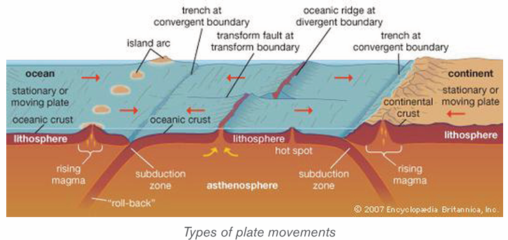
The plate movements are characterized by the following:
• Due to its relatively low density, continental crust does not sink; but it is
the oceanic crust which is denser that can sink. Oceanic crust is then
formed and destroyed, continuously;
• Continental plates, such as the Eurasian plate, may consist of both
continental and oceanic crust;
• Continental crust may extend far beyond the margins of the landmass;
• Plates cannot overlap. This means that either they must be pushed
upwards on impact to form mountains, or one plate must be forced to
downwards into the mantle;
• No gap may occur on the earth’s surface so, if two plates are moving
apart new oceanic crust originating from the mantle is formed;
• The Earth is neither expanding nor shrinking in size. Thus, when the
new oceanic crust is being formed in one place, older oceanic crust is
being destroyed in another;
• Plate movement is slow and is usually continuous. Sudden movements
are detected as earthquakes;
• Most significant landforms (folded mountains, volcanoes, insular
arcs, deep sea trenches, and batholith intrusion) are found at plate
boundaries.
Major landforms resulting from plate movements: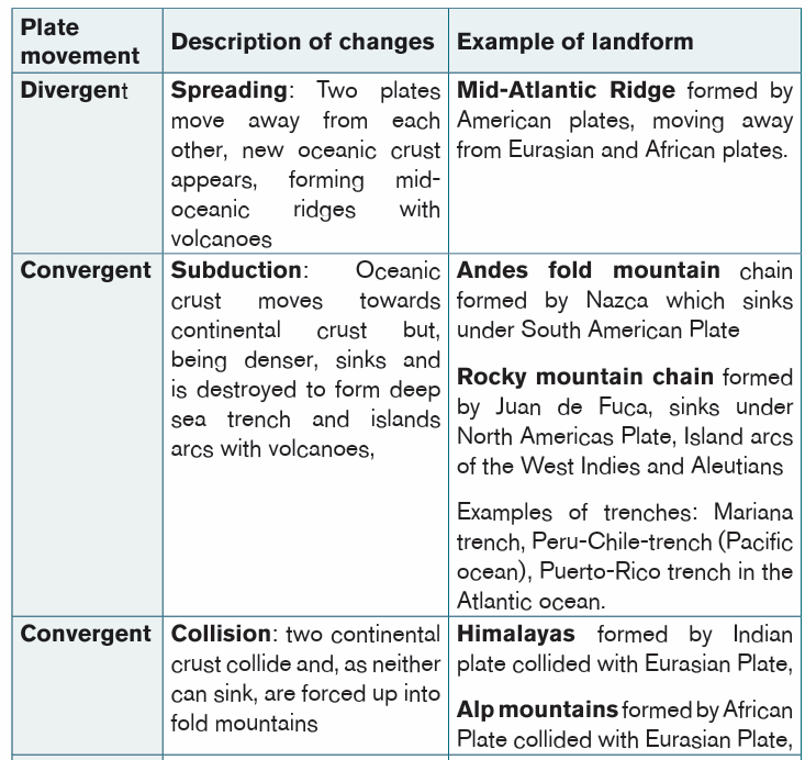

Application activity 2.4
1) Describe SIAL and SIMA in terms of thickness, age, weight and
nature of rocks
2) Explain the difference between convergent movement, divergent
movement and way past movement.
3) Describe the subduction, collision, spreading processes and give
their effects and corresponding motions in relation to plate tectonic
movements.
2.5. Major plates and effects of plate tectonics
Learning activity 2.5
1) Make research using books and a printed hand out and represent on
the world map the major tectonic plates.
2) Identify the effects of the plate tectonic.
2.5.1. Major tectonic plates of the world
The following are the major tectonic plates of the world:
i) The Pacific plate which covers a large part of the basin of Pacific
Ocean.
ii) The Eurasian plate located between the northern mid-ocean ridge of
the Pacific Ocean and the Pacific and Philippines Plates margins.
iii) The North American plate bordered by the eastern margin of the
Pacific plate in the West and mid-ocean ridge of the Atlantic Ocean in
the East.
iv) The South American Plate located between the subduction zone of
Nazca plate in the West and the mid-ocean ridge of the Atlantic Ocean
in the East.
v) The African plate located between the mid-ocean ridge of the Atlantic
Ocean in the West and the mid-ocean ridge of Indo-Australian plate in
the East.
vi) The Indo-Australian plate extends around the Australian subcontinent,
between the Pacific plate and the African Plate.
vii) The Antarctic plate corresponds with the Antarctic continent around
the South Pole.
viii) The Nazca Plate which is located between the Pacific plate and the
South American plate.
However, several minor plates, about 20 have been identified (e.g. Arabian
plate, Bismarck plate, Caribbean Plate, Carolina plate, Cocos plate, Juan de
Fuca plate, Nazca or East Pacific plate, Philippines plate, Scotia plate among others).
2.5.2. Effects of plate tectonicsThe following are the main effects of plate tectonics:
i) Earthquake
This is a series of vibrations induced in the earth’s crust by the abrupt separation
and echo of rocks in which elastic strain has been slowly accumulating. This
sudden violent shaking of the ground typically causes great destruction, because
of movements of seismic waves within the earth’s crust.
Most earthquakes occur as the result of the sudden movement along a fault
line between two adjacent tectonic plates. These have several impacts likelandscape modification, destruction of houses, tsunamis, etc.
ii) A volcanic eruption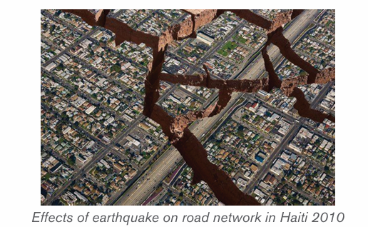
A volcanic eruption occurs when hot materials (molten materials) are thrown out
of a volcano. Lava, rocks, dust, and gas compounds are some of these materials
which are ejected out during volcanic eruption. Volcanic eruption take place
when a plate moves over the top of another plate, then the energy and frictionmelt the rock and push it upwards.
iii) Tsunamis
Tsunamis are giant waves, often generated at destructive plate margins that
can cross oceans. They occur when a sudden, large scale change in the area
of an ocean bed leads to the displacement of a large volume of water and the
subsequent formation of one or more huge waves. When a major seismic tremor
occurs underneath a body of water, the energy from that tremor is released into
the surrounding liquid. The energy spreads out from its original site, traveling
through the water in the form of a wave.
Tsunamis have exceptionally long wave-length up to 10 km and can cross
oceans at speeds of up to 700 km/hour but can sometimes be imperceptiblewhen their magnitude is low.
Application activity 2.5
1) Conduct your own research to identify the minor tectonic plates of
the world and locate them geographically.
2) Apart from the distribution of the continents, what are other effects of
plate tectonics?
3) Identify the major seismic and volcanic zones in the world and explain
the impact of those natural hazards referring to the tectonic plates.
4) Our country, Rwanda, is in a region which is tectonically active and
subjected to earthquakes events. The more documented earthquake
is the one which occurred on 3rd and 4th February 2008. It occurred
on Sunday about 09h31 with the magnitude of 6.1 and 5, and on
Monday the 4th February 2008 and affected mostly Nyamasheke and
Rusizi Districts, Western Province. 37 people died, and 643 injured
including 367 traumatized. Many houses were destroyed in these two
Districts where 1,201 families were rendered homeless:
Knowing the causes of the earthquake, explain how Rwandans cancope with it and its impacts and other resulting natural hazards.
Skills Lab
Basing on the distribution of continents and oceans basins, discuss thegeological evidences of continental drift.
End unit assessment
1) What is the contribution of Wegner’s theory on the distribution of
continents?
2) Basing on the knowledge acquired in this unit, explain the relationship
between the earthquakes which occur in the region of the western
rift valley of Africa where Rwanda is located with the continental drift.
3) Using a map, represent graphically the main tectonic plates of the
world map.
4) Discuss the consequences of the plate tectonics on population insome specific areas of the world.
UNIT 3:EXTERNAL LANDFORM PROCESSES AND RELATED FEATURES
Key Unit competence:
By the end of this unit, I should be able to demonstrate an understanding ofdifferent landforms resulting from the external processes.
Introductory activity
Observe the photographs below and explain the processes that affectedthe rocks that appear on them.
3.1. Definition, types and process of weathering
Learning activity 3.1
1. Differentiate physical weathering from chemical weathering
2. Outline the processes of chemical weathering
3.1.1. Definition of weathering
Weathering refers to the process of disintegration and decomposition of rocks
into small particles by the action of weather and living organisms.
Agents of weathering include the temperature, rainfall (water), wind, animals
and plants (vegetation).
3.1.2. Types of weathering and processes
There are three types of weathering namely physical or mechanical
weathering, chemical weathering and biological weathering which cuts
across each of the physical and chemical weathering.
i) Physical weathering
Physical weathering refers to the breaking down or disintegration of rocks,
without any change in the chemical or mineral composition of the rock being
weathered. Rocks disintegrate into smaller particles but maintain their previous
chemical characteristics. Only the physical size and shape change. Physical
weathering is mostly influenced by temperature changes.
Processes of physical weathering include:
1) Thermal expansion or insolation weathering:
This process is caused by the changing of temperature ranges which
causes differential heating of minerals forming the rock. When heated
dark minerals expand, faster than others resulting in cracking andfragmentation of the rock
2) Exfoliation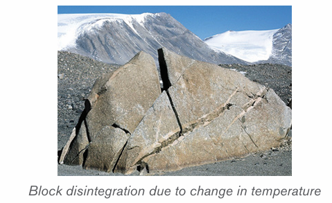
Exfoliation occurs when there is expansion of rocks during the day and
contraction of rocks during the night due to repeated temperature changes.
This process is common in arid and semi-arid regions. This results into rocks
of a few centimeters thick to start peeling off (breaking away) leaving behindexfoliation domes.
3) Freeze thaw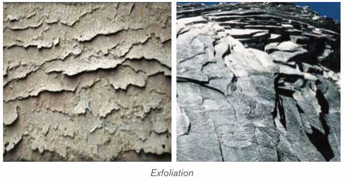
This process also called frost weathering (or frost shuttering) occurs due to
water that enters into the cracks of the rocks; this water freezes and expands
exerting pressure within cracks. Water from rain or melting snow and ice is
trapped in a crack or joint in the rock.
If the air temperature falls below freezing point, the water freezes and expands.
As a result, the rock becomes weak and breaks. This process is common in cold
regions, especially glacial, periglacial and high mountainous zones. The figure
below shows steps from infiltration of water into the rock to the condensationwithin rock fissure which result in the fragmentation.
4) Pressure release
The process of pressure release known as the unloading or dilatation
weathering occurs when materials on top are removed by erosion. This releases
(decreases) pressure, which causes the materials below to expand and crackparallel to the surface.
5) Salt crystallization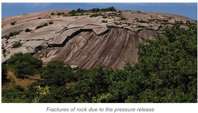
The process of salt crystallization weathering illustrated on the figure below
occurs when saline water (or water carrying salts in solution) passes through
cracks and joints in rocks. As it evaporates, the dissolved salts change into salt
crystals. These crystals expand within cracks as they are heated up and applypressure on the rock leading to its breaking up.
6) Shrinkage weathering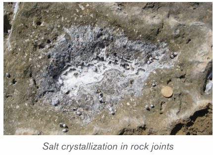
Some clay rocks expand after absorbing water. For instance, there are some
clays which swell when they absorb water during rainy seasons. This results
in increase in their volume. During dry seasons, they massively lose this water
through evaporation and they contract. This process of alternation of expansion
of these rocks during the wet season and contraction of clay during the dry
season is known as shrinkage. This creates stresses and weakness of rocks
causing cracks within the rock.
7) Granular disintegration
This takes place almost in the same way as exfoliation except that in this type,
rocks disintegrate into small particles called granules. It is produced either by
differences in thermal expansion and contraction, or through the frost heaving
process (congeliturbation).
ii) Chemical weathering
This is a type of weathering which involves a complete change in the chemical
and mineralogical composition of the rock resulting into the disintegration of
rocks. It is common in areas which experience alternating wet and dry seasons.
The following are the chemical reactions that take place during weathering:
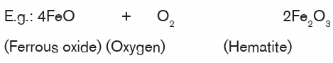
1) Oxidation: oxidation is one of the varieties of chemical weathering
in which oxygen dissolved in water reacts with certain rock minerals,especially iron, to form oxides.
2) Carbonation: This is the process through which rain water dissolves the
atmospheric gases of carbon dioxide (CO2 ) to form a weak carbonic acid
which reacts rocks to wear (weather) them away especially in limestone
areas. After reaction, new compounds are produced as it is shown by thefollowing equation:

3) Dissolution: Dissolution is one of the less important forms of chemical
weathering, in which solid rocks are dissolved by water. When water (e.g.
rainwater) mixes with carbon dioxide gas in the air or in air pockets in soil,
a weak acid solution, called carbonic acid, is produced. When carbonic
acid flows through the cracks of some rocks, it chemically reacts withthe rock causing some of it to dissolve.
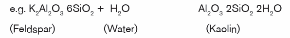
4) Hydrolysis: Hydrolysis involves water combining with rock minerals to
form an insoluble precipitate like clay mineral. Compared to hydration
- a physical process in which water is simply absorbed, the hydrolysis
process involves active participation of water in chemical reactions toproduce different minerals.
5) Hydration: Hydration is one of the major processes of mechanical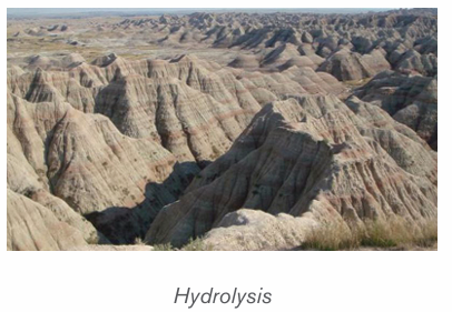
weathering, involving the addition of water to a mineral, causing it to
expand and thereby initiate stress within the rock. For example the
conversion of hematite to limonite. Once minerals have experienced
hydration, they become more susceptible to the effects of chemicalweathering, especially those of carbonation and oxidation.

6) Solution: is a process in which the minerals in the rock directly dissolve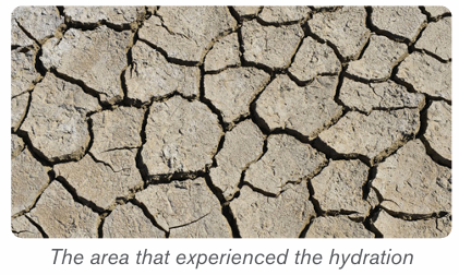
in water without their chemical and mineralogical composition being
altered. e. g. olivine, Rock salt (calcium chloride) and calcium bicarbonate
are easily weathered in solution.e.g. NaCl + H2O → Na+, Cl- (dissolved ions with water).
7) Chelation: Chelation is a form of chemical weathering by plants. It is a
complex organic process by which metallic cations are incorporated into
hydrocarbon molecules. In fact, the word chelate means a coordination
compound in which a central metallic ion is attached to an organicmolecule at two or more positions.
iii) Biological weathering
Biological weathering is a process of rock disintegration (decay) due to the
influence of living organisms both growing plants and animals. The diversity of
life in soil includes plants, algae, fungi, earthworms, flatworms, roundworms,
insects, spiders and mites, bacteria, and burrowing animals.
Plants wear away the rocks by their roots which widen the rock joints hence
allowing in other weathering agents like water to disintegrate the rocks. Some
plant roots also have chemicals at the tips of their roots which are acidic and
hence cause rock weathering.
Tree roots find their way into cracks or joints in the rocks. As they grow, they
cause the joints to become bigger. The end result is that the rocks break intosmaller pieces at some points.
Burrowing animals like rodents and moles, warthogs (wild pigs) and wild animals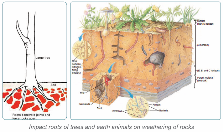
in game parks like the chimpanzee, excavate the rocks and as such, they break
up the rocks hence weathering them. Man also disintegrates rocks through hisactivities.
Man’s activities such as mining, construction, quarrying, agriculture, etc. result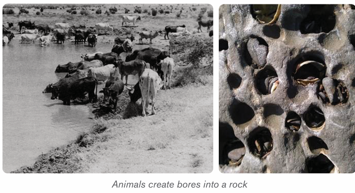
in such a fast rate of disintegration of rocks.
Application activity 3.1
Use your local environment to identify the evidences of biological weathering.
3.2. Factors influencing weathering and interdependence
of physical and chemical weathering
Learning activity 3.2
Using the diagram below, explain how these elements influence the rate ofweathering in your local area.
A number of factors are required for weathering to occur in any environment.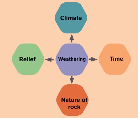
The major factors of weathering include relief, living organisms, time, climateand rock (parent material),
i) Relief
The term relief refers to the nature of landscape or topography. It influences
significantly the weathering process because it controls the flowing of run
off and infiltration of water through slope exposition, steepness and length. In
mountainous regions, the windward slopes receive heavy rainfall which may
speed up chemical weathering, whereas the leeward sides receiving little
amount of rain becoming arid. This favors physical weathering to dominate onthe leeward part.
ii) Living organisms
Living organisms include plants and animals. They both contribute to weathering
in a number of ways. Growing roots of trees widen and deepen into the ground
and open up joints. Animals ranging from the big to small, including man affect
the rate of weathering both mechanically and chemically. Animals and micro
organisms mix soils as they form burrows and pores, allowing moisture andgases to move about.
iii) Time
The longer a rock is exposed to agents of weathering, the more weathered it is
likely to be and vice-versa. Young rocks such as solidified volcanic rock after a
fresh volcanic eruption are likely to be less weathered than rocks formed long ago.
iv) Climate
The key components of climate in weathering are moisture and temperature.
The type and amount of precipitation influence soil formation by affecting the
movement of ions and particles through the soil, and aid in the development
of different soil profiles. High temperatures and heavy rainfall increase the rate
of chemical weathering. Arid and semi-arid areas are associated with physical
weathering since there is low rainfall and high temperature. As the rocks
expand during a period of high temperature and contract during a period of
low temperature, they develop cracks. In addition, equatorial regions with highrainfall and high temperature experience fast and deep chemical weathering.
v) Nature of rocks
Nature of the rock determines the rate at which it may break down. Their nature
depends on rock forming minerals. Some minerals are easily soluble. Also
environmental condition such as organic acids and temperature may increase
the rate of weathering of rocks. Soft rocks, for example, break down more easily
than hard rocks. Similarly, jointed rocks (rocks with cracks) break down faster
than rock substances without joints.
vi) The interdependence of physical and chemical weathering
There is interdependence between mechanical and chemical weathering.
Chemical weathering to occur needs first mechanical process which provides
fragmented pieces of rocks. These rock fragments are then attacked by the
chemical process of weathering. Many reasons can be advanced to justify their
interdependence:
• The joints and crack found in a rock as a result of physical weathering
allow deeper penetration of water which leads to chemical weathering.
• Some rocks are dissolved in water and weathered away in solution.
The solutions formed may later undergo precipitation leading to the
formation of crystal. These crystals will exert a lot of pressure that will
disintegrate the rocks physically.
• Hydration (chemical process) results in a high rate of absorbing water
by rocks .e.g.: hematite, limonite which makes these rocks to peel off in
a physical process called spheroidal weathering.
• The physical process of frost shattering opens up cracks in the rock
and when these cracks are occupied by water, chemical weathering
process takes place. e.g. carbonation.
• Roots of plants which expand within bedding planes of rocks and
burrowing animals which drill holes in rocks allow water entry into theserocks which accelerates chemical weathering.
Application activity 3.2
Visit your local environment and explain how relief and climate have influencedthe rate of weathering.
3.3. Landforms associated with weathering and their
importance
Learning activity 3.3
1. Identify the features associated to weathering
2. Analyse the importance of the following weathering features
a) Cave
b) Oasis
Landforms processes may be similar of different depending on whether rocks
have the same or different mineralogical compositions. The major landforms indifferent geological structures are briefly presented in the following paragraphs.
3.3.1. Landforms associated to weathering in limestone regions
Limestone is a sedimentary rock in which calcite (calcium carbonate: CaCO3 )
is the predominant mineral, and with varying minor amounts of other minerals
and clay. Limestone rocks are very sensitive to organic acids derived from the
decomposition of living organisms.
The major landforms associated with weathering in limestone regions are Karsts
landforms that include: caverns, stalagmites, stalactites, pillar, dolines, limestonepavements (uvalas), poljes.
1) Caverns
Caverns or caves are also one of the important characteristic features of
groundwater in limestone regions. Caverns are formed in several different
ways. The rocks in which most caverns occur are salt, gypsum, dolomite andlimestone, with the latter by far the most important.
2) Doline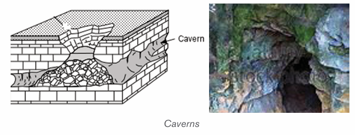
Doline also called Dolina is a round or elliptical hollow on the surface of a
limestone region which is formed when several small hollows merge. The small
hollows are formed when water starts acting on the points of convergence ofjoints on the surface.
3) Uvala
Uvala is a large surface depression (several km in diameter) in limestone terrain
(karst region). It is formed by the coalescence of adjoining dolines and has anirregular floor which is not as smooth as that of Polje.
4) Polje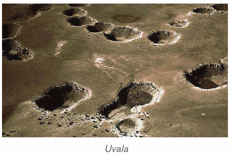
Polje is a large depression in a karst region with steep sides and flat floor. If it isdrained by surface water sources, it is termed as open Polje.
5) Stalactites
Stalactites are protrusions on top of limestone cave formed as results of waterdissolving some rocks which form a solution that leaks from the roof.
6) Stalagmites
Stalagmites are formed like a columnar concretion ascending from the floor
of a cave. It is formed from the re-precipitation of carbonate in calcite form
perpendicularly beneath a constant source of groundwater that drips off the
lower tip of a stalactite or percolates through the roof of a cave in a karstenvironment. It may eventually combine with a stalactite to form a pillar.
7) Pillars
Pillars are formed within the weathered limestone cave after the joining together
of stalactites from up and stalagmites from down. The two may finally meetforming a pillar.
For karst land forms to be formed the following conditions must be in place:
– Precipitation: the major types of precipitation which contribute to
groundwater are rainfall and snowfall.
– Slope: infiltration is greater on flat areas since water is likely to remain
in one place for a long time given that other factors are favorable. On
steep slopes, a lot of water is lost through surface run-off with little
infiltrating in the ground.
– Nature of the rock: For groundwater to percolate and accumulate
there must be spaces within the rocks for it to pass through as well as
to occupy further beneath.
– Vegetation cover: the presence of vegetation increases the rate of
infiltration.
– Level of saturation of the ground: The rate of water infiltration is
high when the ground is very dry and the soil is dry; all the air spacesin it are wide open.
3.3.2. Landforms associated with weathering in arid regions
The features formed in these regions as a result of weathering are both erosional and depositional.
a) Erosional features
1) Inselbergs
An inselberg (island hill or mountain in German) called Monadnock in the
United States, is an isolated hill, knob, ridge, or small mountain that rises
abruptly from a gently sloping or virtually level surrounding plain. These forms
are characterized by their separation from the surrounding terrain and frequentlyby their independence of the regional drainage network.
2) Bornhardts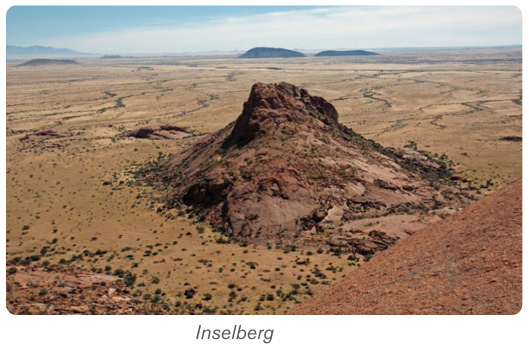
These are dome-shaped and steep-sided rocks that rise up to 30 meters. They
are massive rock, commonly granite comprised of bare rock that stretches
several hundred meters. They take many shapes such as oranges. A goodexample of where Bornhardts are found is Central Australia.
3) Tor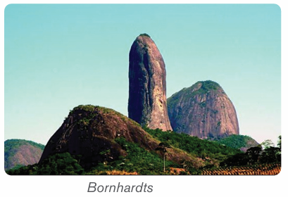
A tor is a pile like hill of rocks or rock peak. It is a product of massive weatheringand comes in all manner of shapes
4) Pediment
This is a rock that is gently inclined at an angle of 0.5 to 7 degrees. It is concave
in shape and is found at the base of hills where rainfall is heavy and falls over ashort period of time.
5) Deflation basins
Deflation is the process whereby loose or non-cohesive sediment are blown by
the wind. Depressions formed in the deserts due to removal of sand through the
process of deflation are called Deflation Basins. They are also called blow
outs or deserts hollows. The depth of deflation is determined by groundwatertable.
6) Mushroom rock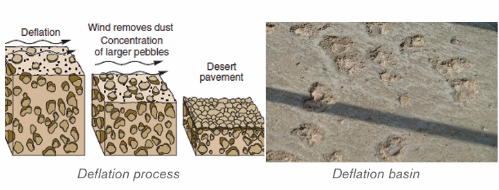
The rocks having broad upper part and narrow base resembling an umbrella
or mushroom are called mushroom rocks or pedestal rocks. These undercut,mushroom-shaped pedestal rocks are formed due to abrasive works of wind.
7) Demoiselles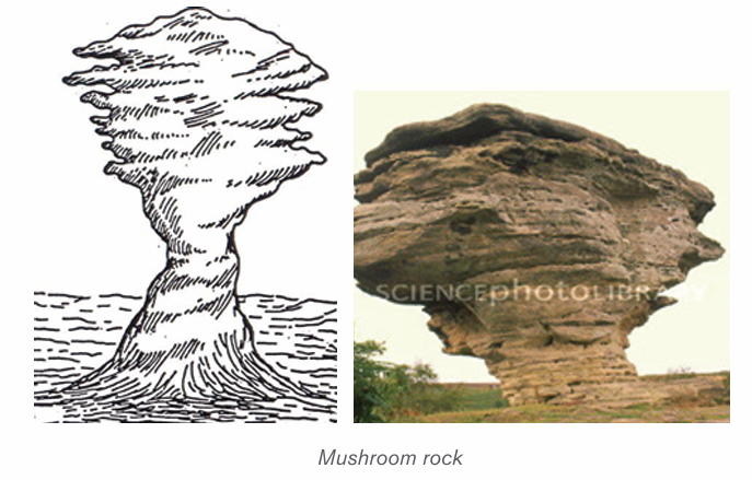
Demoiselles represent rock pillars having relatively resistant rocks at the top
and soft rocks below. These features are formed due to differential erosion of
hard rocks (less erosion) and soft rocks (more erosion). The demoiselles aremaintained so long as the resistant cap rocks are seated at the top of the pillars.
8) Zeugen
Rock masses of tabular form resembling a capped inkpot standing on softer
rock pedestal of shale, mudstone is called Zeugen. The bases of such featuresare broader than their tops.
9) Yardangs
These are formed always in the same way as Zeugens except that yardangs
only develop on landscapes which have alternating rock layers with different
resistance to erosion parallel to the direction of prevailing winds. Winds enter
and scour up rock particles from the soft bands, thus digging depressions within
the soft bands. The resistant hard bands therefore remain standing high up asraised ridges.
10) Reg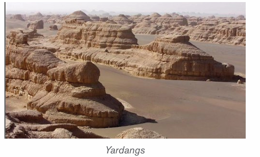
Reg is a desert surface covered with a pebble layer, resulting from long continued
deflation; found in the Sahara Desert of North Africa. Often the winds blow off
all the smaller fragments, and leave the bigger size pebbles and gravels over anextensive area.
11) Oases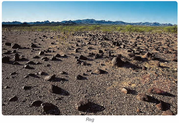
These are depressions that have water in deserts. These are created by strong
winds which remove rock particles from a particular place until a depression isexcavated (created).
b) Depositional features in desert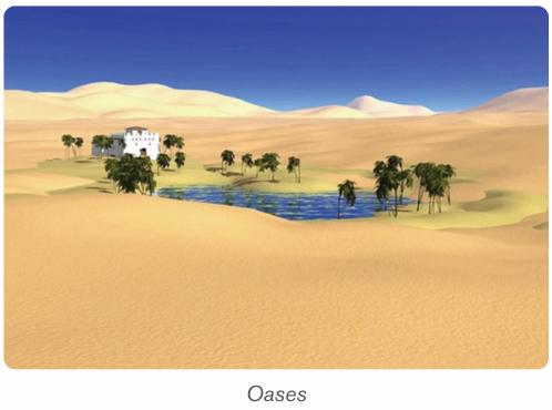
1) Dunes
Dunes are mounds or ridges of wind-blown sand. They are depositional features
of the sandy deserts and are generally mobile. They vary in size and structure.
The main types of sand dunes are Barchan, Transverse Dunes, and Seifs.
– Barkhans
Also called Barchans, these are typical crescent shaped sand dunes. The
windward slope of barchans is gentle and convex, and the leeward slope is
steep and concave. Barchans move slowly, at a rate of meters per year in thedirection of the prevailing winds.
– Seifs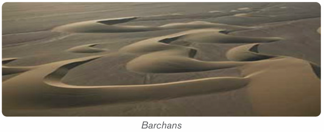
These are long and narrow sand ridge which grow parallel to the direction of theprevailing or dominant wind.
– Transverse dune
Transverse dune is an alongated dune lying at right angles to the prevailling
wind direction. They have a gentle sloping windward side and a steep slopingleeward side, they are commmon in areas with enough sand and poor vegetation.
2) Loess
Loess is a wind-blown deposit of fine silt and dust. It is unstratified, calcareous,permeable, homogenous and generally yellowish in colour.
3) Erg
Erg is also called sand sea or Dune Sea. It is a large, relatively flat area of desertcovered with wind-swept sand with little or no vegetative cover.
3.3.3. Importance of landforms resulting from weathering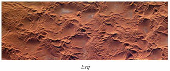
– This soil supports poor scrub vegetation as well as some shrubs and
grasses.
– Chalk landscapes are characterized by undulating topography.
– The surface and underground landforms of karsts appearance are
beautiful to attract tourists.
– Limestone blocks are used for building houses.
– They are also raw materials for cement manufacturing.
– Weathering results into soil formation.
– It produces a number of landforms which modify the nature of landscape
– It produces lateritic soils, which are important in road construction.
– It helps to expose mineral rock on the surface.– It produces clay which is important in pottery industry
Application activity 3.3
1. Examine the contribution of weathering on human activities2. Humid tropical regions are the most affected by weathering. Discuss
3.4. Mass wasting
3.4.1. Definition and types of mass wasting
Learning activity 3.4
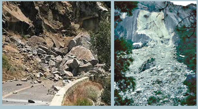
Study the photograph below taken in northern part of Rwanda and describethe cause of the phenomena which happened.
i) Mass wasting
Mass wasting, also called mass movement, is defined as the creeping,
flowing, sliding or falling of rocks and weathered materials down slope under
gravity. It is different from erosion in a sense that, in erosion water physically
transports away the soil particles, in mass wasting water does not wash away
but assists the rock to slide down under the influence of gravity.
ii) Types of mass wasting
Mass wasting is classified into two major categories: Slow movement andrapid movement.
1) Slow movement
Also called creep movements, they are very slow in their motion and they may
occur without being noticed. These slow movements include:
• Soil creep: This is the most common and the most widely spread
type, because it is found in both tropical and temperate climates. The
movement of materials is so slow that they may move a few centimeters
per day. It can be detected by leaning of trees, electric poles andfencing poles in the direction of the slope.
• Solifluction: This is limited to glaciated mountainous regions and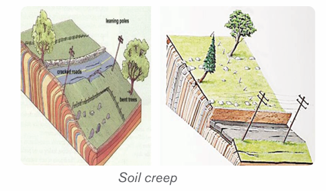
cold climatic areas where thawing causes the saturated surface layerto creep as a mass over underlying frozen ground.
• Talus creep: This is a down slope movement of mainly screes that are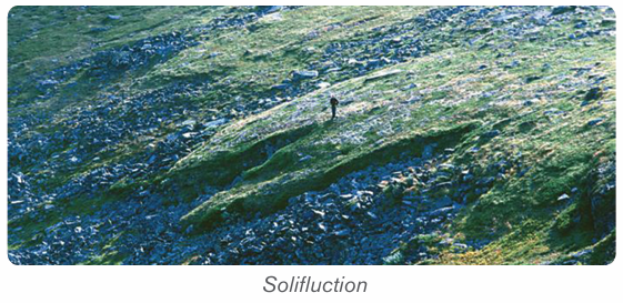
relatively dry. It occurs almost in the same way as soil creep and it also
occurs under tropical and temperate climate.
• Rock glacier creep: This is a slow process of slope failure in which
individual rock boulders with very little soil but with some ice embedded
within them slowly move down slope confined within a channel.
• Rock creep: This is the movement of individual rock boulders slowly
down slope
2) Rapid movement
• Earth flows: These are the rapid down ward movements of clayish or
silty soils along a steep slope.
• Mud flows: These are similar to earth flows but they are muddy and
occur on slopes that receive heavy rainfall. They are very fast. In Rwandathey are common in the Northern and Western-provinces.
• Debris avalanches: This is the most form of rapid flowage due to the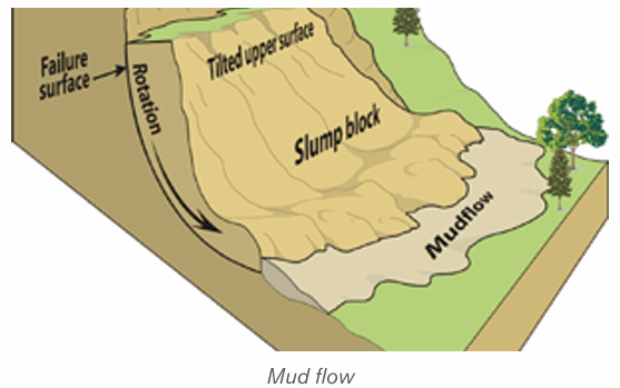
fact that slopes are very steep and there is enough rain to soak slopes.
It occurs on very steep slopes that occur in humid climate.
• Slumping: This is the downward slipping of one or several units of
rock debris, usually with a backward rotation with respect to the slope
over which movement takes place. Undercutting of slopes by streams
and man are the main causes of slumping. The surface of the slumped
mass has a number of step-like terraces.
• Rock slide: This is the type of sliding in which individual rock masses
fall from vertical cliffs or faces of slopes or jointed cliffs.• Rock fall: Here, individual boulders fall freely from a steep rock face.
Landslides: These are also called landslips. They are down-slope gravitational
movements of a body of rock or earth as a unit. It may be induced by natural
agencies (like heavy rain, earthquake) or it may be caused by human interferencewith the slope stability.
3.4.2. Causes of mass wasting
The following are the major causes of mass wasting:
– The degree of slope: The steeper the slope, the higher are the
chances of material movement. Mass wasting is almost nil in gentle and
flat areas.
– The structure and lithology of rocks: Alternating hard and soft rock
layers on a slope can be a cause of slope fall. For example, a layer of
clay on top of limestone layer can easily slide down.
– The degree of lubrication: Most mass wasting processes occur
after a heavy down pour. Water assists to lubricate rock particles and
the layers of rock on top of a slope. Therefore, water provides a medium
of sliding because it reduces internal friction between rock particles
and layers.
– The amount of load on a slope: Slopes which are light rarely fall
compared to those which are heavy. Therefore, additional load on a
slope increase chances of slope fall.
– Tectonic movements: Earthquake and Volcanic eruptions cause
vibrations of the earth which often trigger off widespread movements
of materials such as landslides.
– Climate: The amount and nature of rainfall received in an area
determines the kind of movement that occurs.
– Grazing: The grazing of cattle, movement of elephants and other
animals can cause some tremors on slopes hence making them fall.
– Nature of soil: soils which are infertile and therefore unable to support
vegetation in enough quantities, are more susceptible to mass wasting
compared to soils, which are fertile and therefore able to support dense
vegetation.
– Influence of vegetation: Vegetation help to hold rock materials
together thus reducing their movement on the surface.
– The work of animals: Animals and micro-organisms facilitate deep
weathering which results into the reduced cohesion of the rock particles
on slopes. This therefore leads to easy movement.
– Vulcanicity: Volcanic eruption on the ice capped highlands cause ice
to melt and therefore soak the slopes. This lubrication greatly increasesthe chances of slope movement.
Application activity 3.4
1. Examine the major causes of mass wasting2. Using diagrams distinguish between slumping to rock fall
3.5. Effects and control measures for mass wasting
Learning activity 3.5
Observe the photograph below showing the effects of mass wasting andanswer questions:
1. Analyse the effects of mass wasting.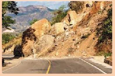
2. Suggest any three measures to control mass wasting.
3.5.1. Effects of mass wasting
The following are some of the effects of mass wasting:
– Threat to life and property: There are several serious incidents
of landslides and rock slides every year. They cause loss of life and
property. In a minor incident they may block only one line of a road, but
in severe cases entire blocks of buildings collapse.
– Loss of vegetation: Mass wasting and soil erosion result in the loss
of surface topsoil which is essential for vegetation. As a result, more
areas become barren.
– Scars and Gullies: In areas where topsoil and vegetation are removed,
bare spots form scars in the landscape. Gullies form on weathered
slopes through rain action and mass wasting in areas with little or no
vegetation. Intense gully cuts up the landscape into large-scale gullies
and ridges and destroys the area. Gullying is common in the bare,
granitic areas.
– Pollution of water: large amounts of geologic materials enter streams
as sediments as a result of this landslide and erosion activity, thus
reducing the potability of the water and quality of habitat for fish and
wildlife.
– Wildlife destruction: Although most kinds of wildlife are able to
retreat fast enough to avoid direct injury from all but the fastest-movinglandslides, often are subject to habitat damage by landslides.
3.5.2. Control measures for mass wasting
Mass wasting, especially landslides, has severe impacts on humans and
environments. For this reason, measures have to be taken for preventing or
mitigating them. Some of the measures are highlighted below:
– Gradients of steeper slopes could be reduced by constructing terraces.
– Retaining walls can be built to stabilize the slope.
– Steep slopes should be inspected regularly, especially during periods
of intense or prolonged rainfall to identify areas prone to mass wasting
for preventive measures.
– More surface drainage channels and ditches can be constructed to
reduce overflowing discharge
– Legislation can restrict development and building in zones prone to
mass wasting.
– Trees can be planted on steeper slopes to stabilize the soil and the slope.
– Appropriate instruments can be installed to monitor slope stability,
providing early warning in areas of concern.– Mass education of people
Application activity 3.5
Make a field trip to observe different areas affected by mass wasting.
Analyse the causes of mass wasting and propose the sustainable measuresto control it.
Skills Lab
Identify any area mostly affected by mass wasting, examine how theCommunity Work / Umuganda may help you to fight against it.
End unit assessment
1. Give the reasons why highlands are the most affected by mass wasting.
2. How have topography and parent rock influenced the rate of
weathering in your area?
3. Explain how the weathering landforms identified in your area affectpositively and negatively human activities.
UNIT 4 : WAVE EROSION AND DEPOSITION
Key Unit competence
By the end of this unit, I should be able to categorise different features
resulting from the wave action and their relationships with the humanactivities
Introductory activityUse the pictures provided below and answer the following questions:
1) Identify the coastal landforms found on figure above.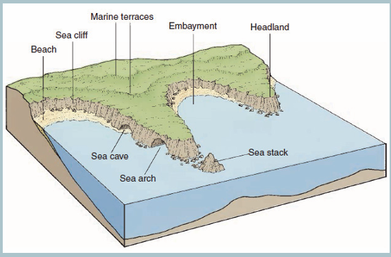
2) Explain the factors for formation of the coastal landforms identifiedon the figure.
4.1. Coastal landforms: Definition of key terms and types of waves
1. Make a research and show the difference between the following
terms related to coastal landforms:
a. Coast
b. Shore
c. Wave
d. Longshore drift
2. Mention the type of waves
Learning activity 4.1
4.1.1. Definition of key terms
The following are definitions of some terms related with coastal landforms:
• Coast: A coast refers to the land that borders the sea or the ocean.
It is a narrow zone where the land and the sea overlap and directly
interact. Some coasts are made up of broad sandy beaches, while
others form rocky cliffs or low-lying wetlands. The shape of the coastline
is determined by factors such as the types of rocks present, the forcesof erosion, and the changes in sea level.
• Shore: This is the area where land meets the sea or ocean. Different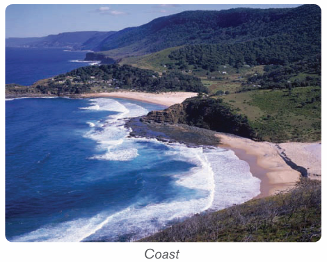
features are found in this area resulting from erosion and deposition of
sediments, ocean or sea waves, as well as the effects of rivers as they
join the sea. It is also called coastline.
• Waves: Waves are defined as undulations of sea/lake water
characterized by well-developed crests and troughs .Waves are created
by the transfer of energy from the wind blowing over the surface of
the sea or from submarine shock waves by earthquakes or volcanic
activities (e.g. Tsunami).
• When waves appear with high frequency they demonstrate the shortwavelengths.
Structure of wave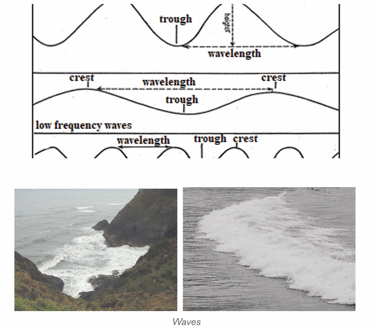
Longshore drift, often used interchangeably with beach drifting, is a general
term for sediment transport parallel to shore in the nearshore zone due to
incomplete wave refraction. In this process sediments transported by the river
systems are moved by ocean waves and ocean currents to form beaches.
Beach drifting, also called littoral drifting, is a process in which waves breaking
at an angle to the shoreline move sediment along the beach in a zigzag fashionin the swash zone. Both processes are illustrated on figure below.
A wave approaching a straight coastline at a large angle will have velocity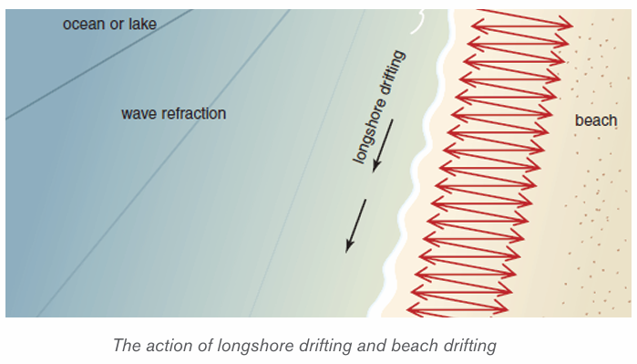
progressively decreasing. This will cause the wave to swing around, but it may
not have enough time to conform fully to the shape of the shoreline beforebreaking, leading to littoral drifting.
4.1.2. Types of waves
There are two main types of waves: constructive waves and destructive waves.
1. Constructive waves: These are waves whose swash is more powerful
than backwash. They are depositional in nature.
2. Destructive waves: These are waves whose backwash is more powerful
than swash. They are erosional in nature.
Other types of waves
– Breaking waves: Formed when the wave collapses on top of itself.
There are four types of breaking waves: spilling, plunging, collapsing, and surging.
Spilling Waves
Spilling waves are waves that are produced when the ocean floor has a gentle
slope. As the wave approaches the shore, it slowly releases energy, and the
crest gradually spills forward down its face until it is all whitewater. These waves
take more time to break than any other wave. Surfers usually call these waves,
“mushy waves.”
Plunging Waves
Plunging waves are formed when the incoming swell hits a steep ocean floor or a
sea bottom with sudden depth changes. As a result, the wave’s crest curls over
and explodes on the trough. The air under the lip of the wave is compressed,
and a crashing sound is often heard. Plungers are more common in offshore
wind conditions.
Surging Waves
Surging waves are produced when long period swells arrive at coastlines with
steep beach profiles. The base of the wave moves fast and does not allow the
crest to evolve. As a result, the wave almost doesn’t break, and there is little
whitewater. Surging waves look friendly, but can be quite deadly because of the
backwash associated with them.
Collapsing Waves
Collapsing waves are a blend between surging and plunging waves. The crest
never completely breaks, and the bottom face of the wave gets vertical and
collapses, resulting in whitewater.
– Deep water waves/Swell waves: Are made up of a number of waves
of different lengths superimposed on each other. They are straight and
long, powerful, and travel great distance.
– Inshore waves: These waves drain the beach as a backwash.
– Internal waves: Formed due to the disturbances found between two
water masses of different density. They are high and become turbulent
currents when they hit a landmass.
– Kelvin waves: Formed due to lack of winds in the Pacific Ocean. They
are high and wide waves, warmer than the surrounding water.
– Progressive waves: Move with a steady speed, so they are called
Progressive Waves. They are of two types:
– Capillary waves: Formed when wind creates pressure over capillarity,
the binding force that holds the water molecules of the ocean surface
together.
– Orbital progressive waves: Formed at the boundary of two liquids
with different density.
– Refracted waves: Travel in shallow water when they approach the
shore. The shallowness decreases the power of the wave and causes
a curve. These are usually seen near headlands and bays.
– Seiche waves: Caused due to the movement within a confined space.
These have long wavelengths and rarely result in any damage as their
height is generally short.
– Shallow water waves: Move in shallow waters. They are of two kinds:
• Tidal waves: Formed due to the gravitational pull of the sun and
the moon on the ocean.
• Seismic Sea Waves/tsunami: Caused due to earthquakes
beneath the ocean. They travel extremely fast in open water, have
significant height in shallow water, and are very dangerous and
devastating.
– Swell waves/Surging waves: Intense waves generating from the
center of a storm where the winds are strong. These expel little energy,travel long distance, and break on distant shores.
Application activity 4.1
1. Differentiate a constructive wave from a destructive wave.
2. If you find an occasion to visit the ocean coast as an East Africa
person, describe the coastal features you would be interested todiscover and explain why.
4.2. Factors determining the strength of waves and wave
action processes
Learning activity 4.2
1. Analyse the factors that determine the strength of waves on the coast2. Explain how waves can cause erosion along the coast.
4.2.1. Factors determining the strength of waves
The following are the major factors determining the strength of waves.
– Wind strength: Wind must be moving faster than the wave crests for
energy transfer to continue;
– Wind duration: Winds that blow for a short time will not generate
large waves;
– Fetch: The uninterrupted distance over which the wind blows without
changing direction;
– Depth of water or roughness of sea bed: As waves enter shallow
water, their speed, wavelength and height increase. Therefore waves
tend to break in shallow water, for example over a bar at the entrance
to a harbor;
– Direction and speed of tide: If the tide direction is against the wind,this will also increase wave height and decrease wavelength.
4.2.2. Wave action processes
The wave action includes erosion, transportation and deposition.
• Erosion: Several mechanical and chemical effects produce erosion of
rocky shorelines by waves. Depending on the geology of the coastline,
nature of wave attack, and long-term changes in sea-level as well as
tidal ranges, erosional landforms such as wave-cut, sea cliffs, and even
unusual landforms such as caves, sea arches, and sea stacks can form.
They erode in four ways as:
1) Solution: it is also called corrosion. It is common on coasts composed
of soluble rocks such as limestone and rock salt.
2) Corrosion or abrasion: this is a type of wave erosion in which the load
already weathered down and hence being transported drag itself on the
bed of the coast and hence wears away some rock particles.
3) Attrition: this is a process of wave erosion which involves the reduction
in size of eroded particles by themselves.
4) Hydraulic action: this is the direction of breaking waves that push water
on a cliff. As this water retreats during a backwash, pressure is suddenly
released and this generates shock waves that weaken rock particles and
make them easily eroded by a backwash.
• Transportation: Waves are excellent at transporting sand and small
rock fragments. These, in turn, are very good at rubbing and grinding
surfaces below and just above water level in a process known as
abrasion. Longshore drift, longshore currents, and tidal currents in
combination determine the net direction of sediment transport and
areas of deposition.
• Deposition: Sediments transported by the waves along the shore
are deposited in areas of low wave energy and produce a variety of
landforms, including spits, tombolo, beaches, bars and barrier
islands. Different types of pediments are deposited along a coast,
sometimes in the form of an accumulation of unconsolidated materialssuch silt, sand and shingle.
Application activity 4.2
1) Wave erosion is done in four ways, differentiate them2) Explain the impact of wind and tides on the strength of the waves.
4.3. Factors for Formation of coastal landforms and
landforms produced by wave and their importance
Learning activity 5.3
In section 4.2, we have defined key terms related to coastal landforms.Observe carefully the following figure and answer the following questions:
1) Identify the landforms produced by wave erosion on the figure above.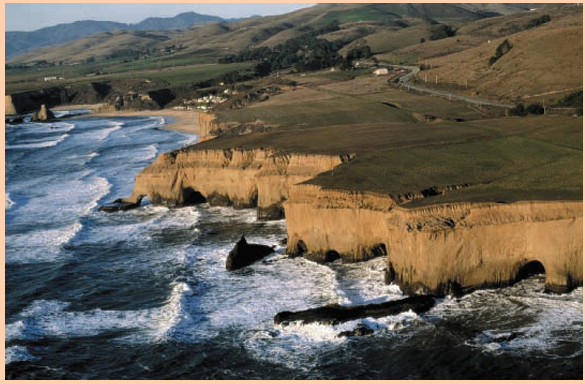
2) Explain the factors that result in the formation of coastal landforms.
4.3.1. Factors influencing the formation of coastal landforms
The following are the major factors influencing the formation of coastal landform:
– Tides: Tides are greatly influencing forces of coastal landforms.
They are commonly semi-diurnal (12-hour cycle). The rise and fall of
water levels produce oscillating currents known as tidal streams. Tidal
currents can transport large quantities of sediments, especially at the
mouths of estuaries. The tidal amplitude also determines the sediments
deposition or erosion and keeps redefining the shoreline of coastal
landforms.
– Nature of rocks at the coast: Wave erosion is more pronounced on
areas that are weak and soluble e.g. jointed and consolidated rocks.
Rocks which are strong and highly consolidated are hard to erode. The
hard and resistant rocks stand as headlands while easily eroded rocks
become bays.
– Openness of the shore to wave attack: Coasts which are totally
exposed to wave attack are easily undermined by wave attack while
those which are sheltered by coastal reefs and islands are protected
from direct wave attack and are hence less eroded.
– Waves: Waves contribute to the erosion of shore. The greater the wave
action, the higher is the erosion and sediment movement. Where the
shoreline is long and flatter, the wave energy gets dispersed. Wherever
there are rock formations, cliffs and short shore area, the wave energy
is high. Strong waves can pick up sediments from deeper waters and
make them available for transportation by the coastal currents. The
larger the wave, the larger the particle it can move. Storm waves can
even move boulders. Even small waves can lift the sediments and
deposit along the coastal shoreline.
– Abundance and size of loads which is used as an abrasive
tool: When materials e.g.; boulders, sands, etc. are in abundance, the
coast line will be easily eroded through corrosion. In the absence of
such materials, wave erosion becomes meager.
– Longshore currents: Parallel movement of water is known as
longshore current and it extends up to the zone of breaking waves
from the coastal shoreline. As the long shore currents are formed by
refracting waves, the direction of flow will depend upon the angle of
the wave which in turn depends upon the wind directions. If the wind
direction is balanced, the sediment movement is also balanced. If the
wind movement and resultant wave action dominate in one direction
great volumes of sediment may be moved in one direction.
– Weather elements: The elements of climate, such as wind, rainfall and
temperature play an important role in formation of coastal landforms.
Winds are directly related to the intensity of waves. Landforms like
coastal dunes are created by wind action. Temperature is required for
physical weathering of sediments. Rainfalls provide runoff for producing
and transporting sediments from land to seashore.
– Gravity: Gravity is an important factor for the development of coastal
landforms. Gravity is indirectly involved in the movement of wind and
waves as well as in downward movement of sediments.
– Nature of coastal rocks: Soft rocks are easily eroded hence forming
erosional features like bays while hard or resistant rocks lead to theformation of headlands.
4.3.2. Landforms produced by wave erosion (destructive wave)
The coastal features formed due to marine erosion by sea waves and other
currents and solution processes include cliffs, caves, geo, stacks, blowhole,
arch, wave-cut platforms.
– Cliffs: A cliff is a steep rocky coast rising almost vertically above
sea water. Cliffs are very precipitous with overhanging crest. The
steepness of vertical cliffs depends on the following: lithology of the
area, geological structure, weathering, erosion of cliff faces and marine
erosion of cliff base.
– Wave-cut platform: Rock-cut flat surfaces in front of cliffs are called
wave-cut platforms or simply shore platforms. They are slightly concave
upward. The origin and development of wave-cut platforms is related to
cliff recession. The plat-form is composed of bare rock or it may containa temporary deposit or rock debris, pebbles or sand.
– Sea caves: A sea cave is a natural cavity or chamber which develops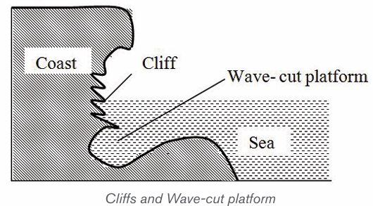
along the coast due to gradual erosion of weak and strongly jointed
rocks by up rushing breaker waves (surf currents). Sea caves are more
frequently formed in carbonate rocks (limestone and chalks) because
they are eroded more by solution processes. However, sea caves are
not permanent as they are destroyed with time.
– Headland: Is a projection of land into the sea or lake. Where alternate
hard and soft rocks occur at the coast, the weak material is eroded to
form a bay while the harder rock resists erosion and remains extending
out into the water as a headland.
– Blowhole: This is a vertical shaft linking the cave to the surface. It is
formed when wave action attacks the back part of the roof of the cave.
At the same time, weathering by solution acts on the line of weaknessfrom the surface downwards to form a blowhole
– Geo: Wave erosion may continue on the roof of the cave along the
blowhole. Hence, the roof of the cave may collapse to form a long andnarrow sea inlet known as Geo.
– Stack/ Column/Pillar: A stack is an isolated rock monolith or pillar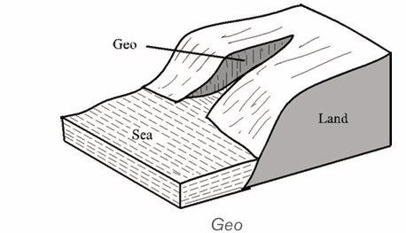
rising steeply from the sea. It is a former part of the adjoining land that
has become isolated from it by wave erosion, probably after havingformed part of a marine arch.
– Sea arch: A sea arch is a natural opening through a mass of rock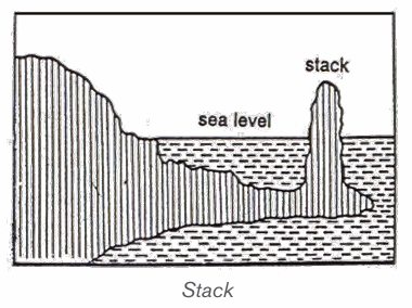
limestone or boulder clay. It is most commonly seen on the sea coast
where waves have cut through a promontory. When the keystone of themarine arch collapses, the feature will become a stack.
4.3.3. Landforms produced by wave deposition (constructive wave)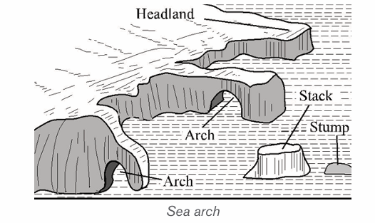
Sediments transported along the shore are deposited in areas of low wave energy.
They produce a variety of landforms, including spits, tombolo, beaches,
bars and barrier islands. Different types of pediments are deposited along
a coast, sometimes in the form of an accumulation of unconsolidated materials
such as silt, sand and shingle.
• Spits: A spit is an embankment composed of sand and shingle attached
to the land on one end and projecting seaward. It may form parallel to
the coast and stretch several kilometers. It may also grow at an angle
across an estuary. Spits are formed when materials are transported and
deposited by the long shore drift, mostly where the orientation of thecoast changes.

•
Tombolo: It is a spit which grows seawards from the coast andjoints to an island.
• Beaches: A beach is located on a wave-cut platform of solid rock and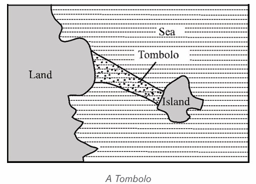
is generally of a low gradient with a gently concave platform. Beaches
may extend for hundreds of kilometers. Beaches are classified into:sand beach, shingle beach, and boulder beach.
Different elements of a beach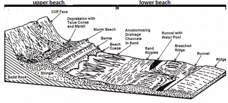
• Bar: A bar is an elongated deposit of sand, shingle or mud occurring
in the sea. It is more or less parallel to the shoreline and sometimes
linked to it. Bars may be of submerged or emergent embankments of
sand and gravel built along the shore by waves and currents. One ofthe most common types of bars is the spit.
• Barrier Islands: Barrier Islands are long, offshore islands of sediments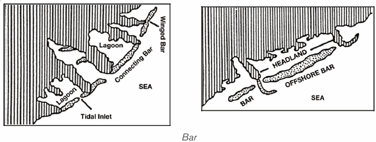
tending parallel to the shore. They form long shorelines adjacent to
gently sloping coastal plains, and they are typically separated from the
mainland by a lagoon. Most barrier islands are cut by one or more tidalwaves.
• Cuspate foreland: This is a large triangular-shaped deposit of sand,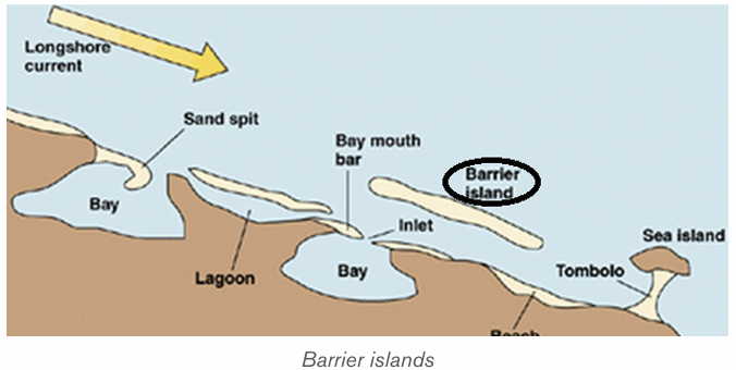
mud and shingles projecting seaward. It is a rare feature formed when
two adjacent spits growing towards each other at an angle join andenclose a shallow lagoon.
• Mud flats: These are platforms of mud, silt and river alluvium kept by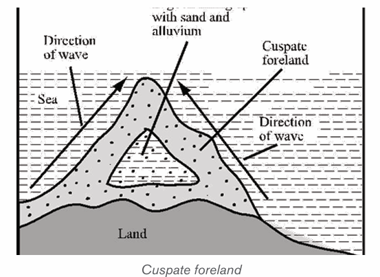
salt-tolerant plants to form a swamp or marshland. They are formed
when tides deposit fine silts along gently sloping coats in bays andestuaries.
• Coastal dunes: These are low-lying mounds of fine sand, deposited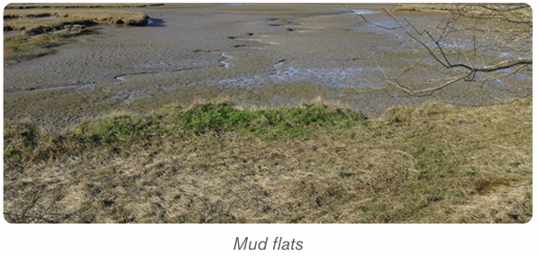
further inland from a wide beach by strong onshore winds. They arecommon in arid and semi-arid coasts.
Application activity 4.3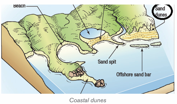
1) Describe landforms produced by wave deposition.
2) Explain the factors influencing the formation of coast landforms.
3) According to you, which landforms are likely to be found around lakesin Rwanda ?
4.4. Importance of coast landforms produced by wave
action and type of coasts
Learning activity 4.4Study the following photograph and answer related questions:
1. Describe the types of coasts.
2. Describe the economic activities that can be carried out in this area
4.4.1. Importance of coast landforms produced by wave
Coastal landforms produced by wave action are very important in different ways
as follows:
– Many of the world’s major cities are located in coastal areas, and a
large portion of economic activities, are concentrated in these cities.
– There are different activities that take place in coastal zones including
coastal fisheries, aquaculture, industry, and shipping.
– Many of coastal landforms are very favourable for tourism that contributes
to the economic development of countries.
– Marine, estuary and coastal wetland areas often benefit from flows of
nutrients from the land and also from ocean upwelling which brings
nutrient-rich water to the surface. They thus tend to have particularly
high biological productivity.
– The world’s fish production is dependent on the nature of coastal
landforms like bays and headlands.
– Beaches support leisure, recreation, trade and mining of sand
– Mud flats and sand dunes have fine silt which attracts mangrove
swamps used in crafts industry.
– Features produced are important in agriculture development
– Cliffs protect the land from wave attack.
– These landform features are used in study purposes.– Cliffs may produce waterfalls important in generation of power.
4.4.2. Types of coasts
There are two types of coasts: Submerged coasts and Emerged coasts.
i) Submerged coasts
Submerged coasts fall into two categories: Submerged upland coasts and
submerged lowland coasts.
A. Submerged upland coasts
When the margin of an irregular upland area is submerged, a more or less
indented coastline is produced. It appears with islands and peninsulas
representing the former uplands, and with inlets indicating the former valleys.
The following are the three types of submerged coasts:
1) Ria coasts: Ria is a Spanish term widely used to describe a submerged
coastal valley or estuary resulting from a rise of the sea level. In the case
of a Ria coast, hills and river valleys meet the coastline at right angles.
The rias are characterized by funnel-shaped which decreases width
and depth as they run inland. The head of a stream which is small isresponsible for the formation of the valley at the inlet.
2) Fiord (Fjord) coasts: A long, narrow inlet of the sea bound by steep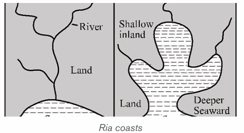
mountain slopes. These slopes are of great height and extend to
considerable depths (in excess of 1,000 m) below sea level. It is formed
by the submergence of glacially over deepened valleys due to a rising
sea level after the melting of the Pleistocene ice sheets. Fiords occur
in western Scotland, Norway, Ireland, Greenland, Labrador, British
Columbia, Alaska, Southern Chile and New Zealand. The main reason
for their existence is the submergence of deep glacial troughs and that iswhy fiords have many characteristics of glaciated valleys.
3) Dalmatian or longitudinal coasts: Dalmatian is a term derived from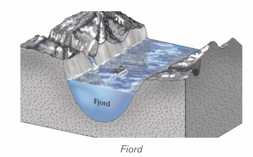
the Yugoslavia Adriatic in which the coast runs parallel with the lineament
of the topography and probably with the underlying geological structure.
A rise of sea level (estuary) has drowned the coastal area, resulting in
a coastline of narrow peninsulas, lengthy gulfs and channels and linearislands. The Dalmatian coast tends to be straight and regular.
4) Submerged lowland coasts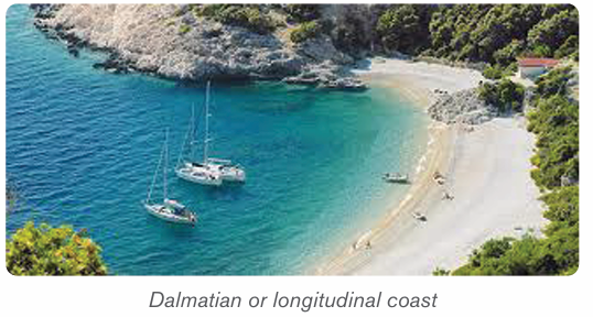
These are formed when a rise in the sea level drowns a lowland coast. The
sea penetrates deep inland along rivers to form estuaries. The rise in base level
causes an increase in deposition by rivers leading to formation of mud flats,
marshes, and swamps which are visible at low tides. Delta: Is a large, flat and
low lying plain of river deposits laid down where a river flows to the sea or lake.A delta is a large area covered by river deposits (alluvium) formed at the mouth of a river
Ii) Emerged coasts
Emerged coasts comprise emerged highlands coasts and emerged lowland
coasts.
A. Emerged upland coasts
Raised beaches: when the sea level drops, wave activity also drops to lower
levels. The wave deposition will be at a new point of low tide level forming a new
beach there, hence leaving the old beach up high at a former point of sea. These
types of beaches are usually evident on land that is far away from the present
edge of the water. They may have been formed at the head of a bay but they are
now isolated on land. Most raised beaches are colonized by vegetation.
Raised cliffs: this is formed when there is a relative fall in the level of the sea.
A raised terrace: the drop in sea level produces a wave cut platform down to
a new level of the sea leaving the former terrace suspended up to the originallevel of the sea before emergence.
B. Emerged lowland coasts
An emerged lowland coast has been produced by the uplift of part of the
neighboring continental shelf. The landward edge of such coastal plain is found
in the southern of USA. It is formed by the fall-line where rivers descend from
the Appalachian in a series of waterfalls. Other examples of emerged lowland
costs are: the northern shore of the Gulf of Mexico and the southern shore ofthe Rio-de-la Plata in Argentina.
Application activity 4.4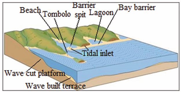
1. Give five examples of cities located in coastal areas, including at least
two cities located in East African Community.
2. Indicate the type of submerged coast, and describe its characteristics.
3. Suppose that you live nearby the coast, explain the business
opportunities that you may carry out there and the challenges you can face.
4.5. Coral reefs: Nature, types and formation of coral reefs
Learning activity 4.5
Observe the figure below of a coral reef and answer the following questions:answer the following questions:
1. What do you think are the elements that constitute a coral reef?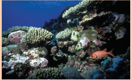
2. Analyze the processes in which coral reefs are formed.
3. What do you think are the problems related to coral reefs formation?
A coral is a hard limestone rock made up of the skeletons of tiny (very small)
marine organisms, known as coral polyps. Also coral reefs are limestone rocks
which are formed from dead animals called corals. Corals have a hard shell of
calcite, formed by the extraction of calcium carbonate from sea water.
They are generally attached to submarine platforms or islands submerged underseawater.
A. Types of coral reefs
On the basis of the location of the main types of reefs, we distinguish tropical
coral reefs and marginal belt coral reefs. But, by categorizing on the basis of
the nature, the shape and the mode of occurrence, we have three types of coralreefs which are: fringing reefs, barrier reefs and atoll.
1) Fringing reefs (Shore Reefs): These are the coral reefs developed
along the continental margins or along the islands. The seaward slope is
steep and vertical while the landward slope is gentle. A fringing reef runs
as a narrow belt which grows from the deep sea bottom sloping steeply
seaward side. It is separated from the main land by a narrow and shallow lagoon.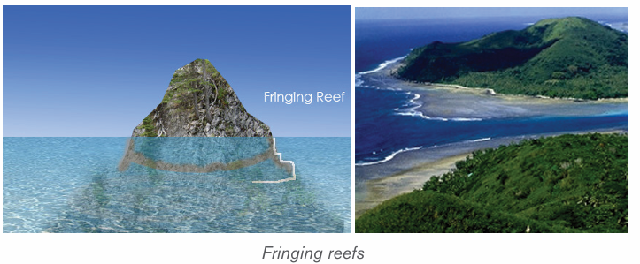
2) Barrier reefs: Barrier reefs are extensive linear reef complexes that areparallel to a shore and are separated from it by a deep and wide lagoon.
3) Atoll: An atoll is a roughly circular (annular) oceanic reef system
surrounding a large and often deep central lagoon. There are three types
of atolls, namely, true atolls, island atolls and coral island or atoll islands.
– True atolls are characterized by circular reef enclosing a shallow
lagoon but without an island;
– Island atolls have an island in the central part of the lagoon enclosed
by circular reefs;
– Coral islands or atoll islands do not have islands in the beginning but
later on islands are formed due to erosion and deposition by marine waves.
B. Formation of coral reefs
1) The process of coral reefs formation
Coral reefs start to form when the free-swimming coral larvae attach to the
submerged rocks or other hard surfaces along the edges of islands or continents.
This continues to grow under the influence of coral reefs conditions to grow in
any types accordingly. The coral reef formation takes three stages: fringing,barrier and atoll.
Concerning the process, a typical fringing reef is attached to or borders the
shore of a landmass, while a typical barrier reef is separated from the shore by
a body of water. An atoll began as a fringing reef around a volcanic island. Over
time, the volcano stopped erupting, and the island began to sink. Over time,
coral growth at the reef’s outer edge would push the top of the reef above the
water. As the original volcanic island disappeared beneath the sea, only an atollwould remain.
1) The general conditions influencing coral formation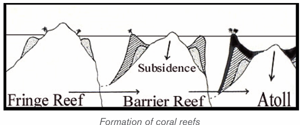
• Corals are found mainly in the tropical oceans and seas because they
require high mean annual temperature ranging between 20°C and
21°C for their survival. They cannot survive in the waters having either
very low temperature or very high temperature.
• Corals do not live in deep waters, that is, not more than 60-77 meters
below the sea level.
• There should be clean sediment-free water because muddy water or
turbid water clogs the mouths of coral polyps resulting into their death.
• Though coral polyps require sediment-free water, fresh water doesn’t
allow their growth. This is why corals avoid coastal lands and live away
from the areas of river mouths.
• High salinity is injurious to the growth of coral polyps because such
waters contain little amount of calcium carbonates whereas lime is
important food of coral polyps. The oceanic salinity ranging between
27% and 30% is most ideal for the growth and development of coral polyps.
• Ocean currents and waves are favorable for corals because they bring
necessary food supply for the polyps.
• There should be extensive submarine platforms for the formation of
colonies by the coral polyps. Besides, polyps also grow outward from
the submarine platforms.
• Human activities like deforestation, industrialization cause global
warming, which adversely affects corals in their habitats. Corals are
more susceptible to long-term climatic change. Corals are generally
termed as rainforests of the oceans. These cannot survive in extremewarm environment.
Application activity 4.5
1) Using illustrative graphics, differentiate the types of coral reefs.2) Explain the conditions for coral reefs formation.
4.6. Theories of the origin of coral reefs, Problems facing
the development and growth of coral reefs, Impact of coral reefs
Learning activity 4.6
1. Using concrete examples, show how coral reefs are important2. Mention the theories explaining the formation of coral reefs
4.6.1. Theories of the origin of coral reefs
There are three main theories about the origin of coral reefs that are:
• The subsidence theory by Darwin,
• Antecedence theory by Murray,• Glaciated control theory by Daly.
A. Darwin’s Theory or subsidence theory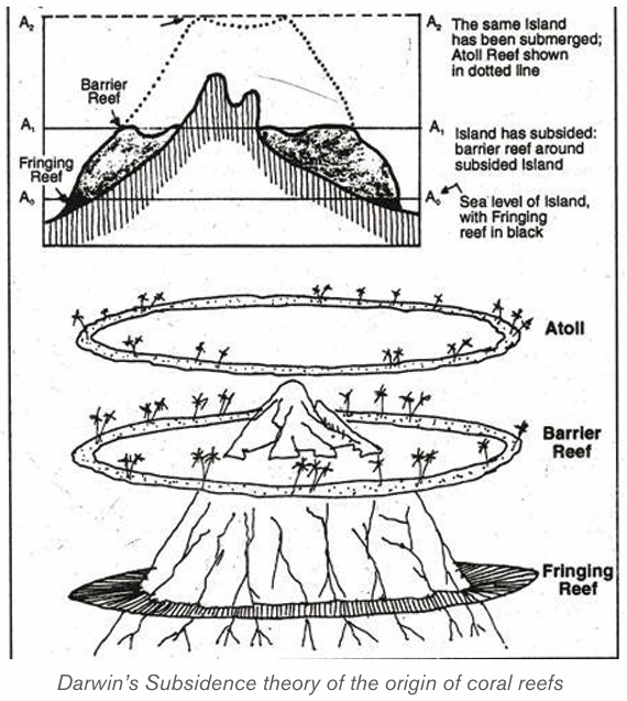
Darwin, a British naturalist developed his theory as follows:
– Darwin’s theory starts with a volcanic island which becomes extinct.
– As the island and ocean floor subside, coral growth builds a fringing
reef, often including a shallow lagoon between the land and the main reef.
– As the subsidence continues, the fringing reef becomes a larger barrier
reef further from the shore with a bigger and deeper lagoon inside.
– Ultimately, the island sinks below the sea, and the barrier reef becomesan atoll enclosing an open lagoon.
B. Murray’s theory or antecedence theory
The Antecedent-Platform or uplift theory for the origin of coral reefs stipulates
that:
– Any bench or bank that is located at a proper depth within the circum
equatorial coral-reef zone is potentially a coral-reef foundation.– If ecological conditions permit, a reef may grow to the surface from
such a foundation without any change in sea-level.
– Reef foundations, or platforms, are formed by erosion, deposition,
volcanic eruption, or earth movement or by combinations of two or
more of these processes.
– The theory agrees that atoll coral reefs formed when the tops of islandswere undergone wave action resulting to a platform.
C. Daly’s theory or glaciated control theory
Daly studied the coral reefs of Hawaii and he was greatly impressed by two
things:
– The reefs were very narrow and there were marks of glaciations
– There should be a close relationship between the growth of reefs and
temperature.– According to Daly’s hypothesis, in the last glacial period, an ice sheet
had developed due to the fall in temperature. This caused a withdrawal
of water, equal to the weight of the ice sheet. This withdrawal lowered
the sea level by 125-150 m.
– The corals which existed prior to the ice age had to face this fall in
temperature dining this age and they were also exposed to air when
the sea level fell. As a result, the corals were killed and the coral reefs
and atolls were planed down by sea erosion to the falling level of sea
in that period.
– When the ice age ended, the temperature started rising and the ice
sheet melted. The water returned to the sea, which started rising. Due
to the rise in temperature and sea level, corals again started growing
over the platforms which were lowered due to marine erosion.
– As the sea level rose, the coral colonies also rose. The coral colonies
developed more on the circumference of the platforms because food
and other facilities were better available there than anywhere else.
– Hence, the shape of coral reefs took the form of the edges of submerged
platforms, a long coral reef developed on the continental shelf situated
on the coast of eastern Australia. Coral reefs and atolls developed on
submerged plateau tops. After the ice age, the surface of platforms
was not affected by any endogenic forces and the crust of the earthremained
4.6.2. Impact of coral reefs
Coral reef landforms have crucial impact in world economic activities.
These are:
– Tourist attraction: Coastal features like caves, beaches and arches
are tourist attractions.
– Development of harbors: Rias and fiords favor the development of
deep sheltered harbors.
– Industrial raw materials: Coral limestone provides raw materials for
the manufacture of cement. This is obtained from raised coral reefs.
– Fishing grounds: Fiords contain sheltered waters which are suitable
for feeding and development of fishing ports. Continental shelves
contain shallow waters which favor growth of planktons. This makes
them rich fishing grounds.
– Habitat for marine life: Lagoons, mud flats and mangrove swamps
are good habitats for marine life. This has promoted the development of
research on marine life and establishment of marine parks.
– Impact on agriculture: emerged coasts have sand, gravel and bare
rock. These inhibit agriculture, especially crop farming.
– Transport barrier: coastal features such as sandbars and coral reefsinhibit water transport and development of ports.
4.6.3. Problems facing the development and growth of coral reefs
The following are the major problems facing the development and growth of
coral reefs:
– Overfishing: Increasing demand for food fish and sea tourism has
resulted in over fishing of not only deep-water commercial fish, but
key reef species as well. This affects the reef’s ecological balance and
biodiversity.
– Coral disease: coral diseases contribute to the deterioration of coral
reef communities around the globe. Most diseases occur in response
to the onset of bacteria, fungi, and viruses.
– Destructive fishing methods: Fishing with dynamite, cyanide
and other methods that break up the fragile coral reef are highly
unsustainable. Dynamite and cyanide stun the fish, making them easier
to catch. Damaging the coral reef habitat on which the fish rely reduces
the productivity of the area.
– Unsustainable tourism: Physical damage to the coral reefs can occur
through contact from careless swimmers, divers, and poorly placed
boat anchors. Hotels and resorts may also discharge untreated sewage
and wastewater into the ocean, polluting the water and encouraging
the growth of algae, which competes with corals for space on the reef.
– Coastal development: The growth of coastal cities and towns
generates a range of threats to nearby coral reefs. Coral reefs are
biological assemblages adapted to waters with low nutrient content,
and the addition of nutrients favours species that disrupt the balance of
the reef communities.
– Pollution: Coral reefs need clean water to thrive. From litter to waste
oil, pollution is damaging reefs worldwide. Pollution from human
activities inland can damage coral reefs when transported by rivers into
coastal waters.
– Marine debris: It is any solid object that enters coastal and ocean
waters. Debris may arrive directly from a ship or indirectly when washed
out to sea via rivers, streams, and storm drains. Human-made items
tend to be the most harmful such as plastics (from bags to balloons,
hard hats to fishing line), glass, metal, rubber (millions of tires!), and
even entire vessels.
– Dredging operations. They are sometimes completed by cutting a
path through a coral reef, directly destroying the reef structure and killing
any organisms that live on it. Operations that directly destroy coral are
often intended to deepen or otherwise enlarge shipping channels or
canals, due to the fact that in many areas, removal of coral requires a
permit, making it more cost-effective and simple to avoid coral reefs if
possible.
– Global Aquarium Trade: It is estimated that nearly 2 million people
worldwide keep marine aquariums. The great majority of marine aquaria
are stocked with species caught from the wild. This rapidly developing
trade is seeing the movement of charismatic fish species across borders.
Threats from the trade include the use of cyanide in collection, over
harvesting of target organisms and high levels of mortality associated
with poor husbandry practices and insensitive shipping. Some regulation
is in place to encourage the use of sustainable collection methods and
to raise industry standards.
– Alien invasive species: Species that, as a result of human activity,
have been moved, intentionally or unintentionally, into areas where they
do not occur naturally are called “introduced species” or “alien species”.
In some cases, where natural controls such as predators or parasites
of an introduced species are lacking, the species may multiply rapidly,
taking over its new environment, often drastically altering the ecosystem
and out-competing local organisms.
– Climate change: Rising sea levels due to climate change requires coral
to grow to stay close enough to the surface to continue photosynthesis.
Also, water temperature changes can induce coral bleaching in which
sea surface temperatures rose well above normal, bleaching or killing
many reefs.
– Ocean acidification: results from increases in atmospheric carbon
dioxide. The dissolved gas reacts with the water to form carbonic acid,
and thus acidifies the ocean. This decreasing pH is another issue for
coral reefs.
– Coral mining: Both small scale harvesting by villagers and industrial
scale mining by companies are serious threats. Mining is usually done
to produce construction material which is valued as much as 50%
cheaper than other rocks, such as from quarries. The rocks are ground
and mixed with other materials, like cement to make concrete. Ancient
coral used for construction is known as coral rag. Building directly on
the reef also takes its toll, altering water circulation and the tides whichbring the nutrients to the reef.
Application activity 4.6
1. Establish the similarities of the subsidence, antecedence and
glaciated control theories of coral reefs formation.
2. Account for the negative impacts of human activities on the coral
reefs growth.3. Describe the economic importance of coral reefs.
4.7. Sea level change
Learning activity 4.7Observe the following picture and answer the question that follow:
1. Find evidence that the level of water on this picture changes.
2. What do you think can cause that change?
3. Describe any three features observed on this picture
4.7.1. Meaning of sea level change and its resulting features
The sea level change is the variation and fluctuation of the sea level throughout
time. It can contribute to the formation of submergent landforms such as Ria
(a river valley that’s been flooded by the eustatic rise in sea level), fjords and
dalmatian coastline, and emergent landforms such as raised beaches. These
are wave-cut platforms and beaches that are above the current sea level. There
are also some old cliffs (relic cliffs) behind these raised beaches with wave-cutnotches, arches and stacks along them.
4.7.2. Types of sea level changes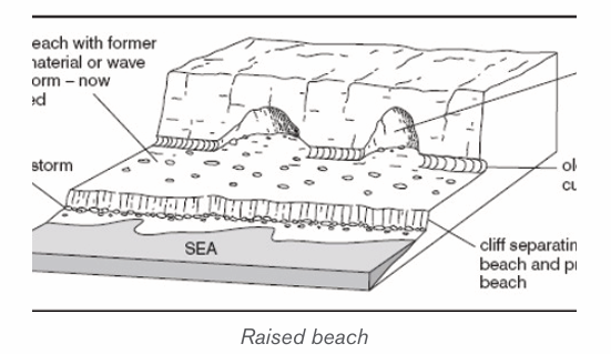
There are two types of sea level changes which are:
• Submergence or Rise of sea level: This is referred to as an increase
in global mean sea level as a result of an increase in the volume of water
in the world’s oceans. This leads to the formation of coastal features of
submergence.
• Emergence or fall of sea level: This is referred to as the decrease in
global mean sea level as a result of a decrease of the world’s oceans.This leads to the production of emergence coastal landform.
4.7.3. Causes of sea level change
The sea level changes daily because of the following causes:
– Eustatic variations in sea level are the effects of external forces.
Most experts agree that human induced global warming is the force
behind the current global sea-level rise. There are three factors that
primarily affect eustatic sea level change that are: thermal expansion of
the ocean, melting of nonpolar glaciers, and change in the volume of
the ice caps of Antarctica and Greenland.
– The changes in global temperature affect the amount of ice stored
on land as water, thus changing the sea levels. A rise in temperatures
causes the ice caps to melt, and sea levels rise, and vice versa.
– The changes in sea levels are also affected by the steric effect.
This is where the density of the water increases or decreases as the
temperature rises or falls. If the temperature rises the water expands
and if it falls the water contracts. It is estimated that sea levels can rise
up to 0.4 mm per year.
– The mass of ice adds weight to the earth’s crust causing it to sink
lower into the mantle resulting into relative rise in the sea-level during
glacial period.
– Isostatic re-adjustment; at the end of glacial period, the mass of ice
melts and the weight is lost from crust which then rises. When the ice
melts the land begins to rise as the weight is removed. This process
results in a relative fall in sea-level. This is called isostatic re-adjustment.
– Uplift/mountain building due to plate movements may also result in
a relative fall in sea-level as land rises up.
– Pre-glacial erosion of a coastline causes the coast rise and endup to the sea level change.
4.7.4. Evidences of sea level changes
The following are evidences of sea level changes:
– The presence of old coastline high above the present sea level:
During the Ice Age the sea levels fall leaving the old coastline. Since
the end of the Ice Age, sea levels have risen again, but not to their
previous levels. The raised beaches continue to be above the present
sea level by quite a distance.
– The estuaries and inlets flooded: Sea level rise after the last Ice
Age caused estuaries and inlets to be flooded. This occurred in South
West England, drowning many river valleys around the coasts of Devon
and Cornwall, and creating Rias. In other more northern areas, glacial
valleys were drowned to create Fjords.
– Isostatic re-adjustment phenomenon: Some places in Scotland
still undergoing isostatic re-adjustment up to 7 mm per year in some areas.
4.7.5. Effects of the sea level changes
Rising sea level has many impacts on coastal areas. The following are some of
them:
– Erosion of beaches and bluffs: Beach erosion is the most common
problem associated with rising sea level. Depending on beach
composition, beaches erode by about 50 to 200 times the rate of sea
level rise. That translates a 2-millimeter (0.08-inch) per year increase
in sea level eroding from 10 to 40 centimetres (3.9 to 15.6 inches)
of coastline per year. Beach erosion has not only a strong ecological
impact, but also a profound economic impact;
– It increases the flooding and storm damage caused by changes
in sea level;
– Contamination of drinking water: as the rising sea crawls farther
and farther up the shore, in many places it will seep into the freshwater
sources in the ground that many coastal areas rely on for their drinking
water. Saltwater is unsafe to drink, and while it is possible to remove
the salt from water, doing so is an expensive and complicated process;
– Interference with farming: Those same freshwater sources we use
for drinking also supply the water we use for irrigation. The problems
here are the same: The intruding sea could make these groundwater
sources saltier. Saltwater can stunt or even kill crops, but creating
freshwater from saltwater is a costly and unsustainable practice;
– Change in coastal plant life: more saltwater hitting the shores
changes the soil composition on the coast, meaning the plant life there
will most likely change as well;
– Threating the wildlife population: Many forms of wildlife make their
home on the beach. As the rising ocean erodes the shoreline and floods
the areas in which coastal animals live, animals like shorebirds and sea
turtles will suffer and die and others will migrate;
– Hurting the economy: the tourism and real-estate industries in
coastal areas are likely to take a hit as prime beachfront properties and
recreational areas are washed away by rising waters. This is a fact thatsome involved in these industries are finding hard to swallow.
Application activity 4.7
1. Explain the causes of sea level change
2. According to you, which feature is more attractive to tourism. Defend
your view3. Explain the environmental effects of sea level changes.
Skills Lab
With help of knowledge and skills acquired in this unit, suggest waysbeaches may be preserved and more productive.
End unit assessment
1) Describe the major features resulting from wave erosion and
deposition processes.
2) Observe the following photographs and answer the questions that follow:
i) Examine the economic activities that should be carried out in the
regions demonstrated on photographs.
ii) According to you, what are the advantages of coast or shore to
people living nearby?
3) Demonstrate the impacts of sea level change to the environment.UNIT 5 : ROCKS AND MINERALS
Key Unit competence
By the end of this unit, I should be able to compare different types of rocksand minerals and evaluate their importance.
Introductory activityObserve the rock provided below and answer the following questions:
1. Identify the types of rocks given above.
2. In which category can they be classified?
3. Which properties can help to identify these rocks and their minerals?4. Explain the economic advantages of the rocks and minerals.
5.1. Rocks: Definition, types and characteristics
Learning activity 5.1
Make a field trip in your environment; observe the rock and identify their
types and distinctive characteristics.
5.1.1. Definition
A rock is a natural aggregate of minerals in the solid state; usually hard and
consisting of one, two, or more mineral varieties. Rocks form the solid part of the
earth’s crust. Rocks may also include substances like clay, sandstones,
shells and corals. Rocks which contain metallic compounds are called ores.
5.1.2. Types of rocks
There are three major groups of rocks namely igneous rocks, sedimentary rocks
and metamorphic rocks. Their classification is based on the mode of formation
and the nature of constituting minerals. Characteristics of each rock group are
briefly described below.
i) Igneous rocks
The word igneous comes from the Latin word ignis, which means fire. Igneous
rocks are rocks formed by cooling of molten material from a volcano or from
deep inside the earth. This molten material from inside the earth is known as
magma. Igneous rocks are also called magmatic rocks or volcanic rocks. Their
formation is associated with the cooling and hardening of molten material from
the interior of the earth.
ii) Sedimentary rocks
Sedimentary rocks are the result of the accumulation of small pieces broken
off from pre-existing rocks (igneous rocks, metamorphic rocks and sedimentary
rocks) or precipitation of dissolved minerals. Sedimentary rocks form when
sediments become pressed or cemented together or when sediments precipitateout of solution.
iii) Metamorphic rocks
The metamorphic rocks get their name from “meta” (change) and “morph” (form).
Metamorphic rocks are formed from pre-existing rocks due to increases in heat
and pressure which alter rock structure and chemical composition. Therefore,sedimentary and igneous rocks can become metamorphic rocks.
There are four factors that contribute to the formation of metamorphic rocks:
– Heat or high temperature: this speeds up the chemical reactions that
result in metamorphic rocks. The heat is from magma, steam from hot
water and rocks sinking deeper into the warmer layer of the crust
– High pressure which changes the mineral and feel of the original rock.
– Nature of the parent rock which determines how resistance it is to change.
– Time which determines the period required for the chemicalreactions to take place.
5.1.3. Characteristics of rocks
A. Characteristics of igneous rocks
Igneous rocks have the following characteristics:
– They are hard, and water does not pass through their joints easily, that
is why they are less affected by erosion;
– Igneous rocks have a lot of minerals;
– They do not have strata or layers;
– They do not contain fossils (fossils are remains of plants and animals
fixed in rocks);
– The number of joints increases upwards in any igneous rock;
– Igneous rocks are mostly associated with volcanic activities and are
mainly found in the volcanic zones. That is why they are also called
volcanic rocks.
Igneous rocks can also be classified based on the chemical and mineralogical
compositions, texture of grains, forms and size of grains, and the mode of origin,igneous rocks are classified as follows:
1) Classification based on the amount of silica
• Acidic igneous rocks: they contain more silica: (≥65% of SiO2 );• Basic igneous rocks: they contain low amount of silica (≤ 45% of SiO2 ).
2) Classification based on the chemical and mineral composition
• Felsic igneous rocks: they are composed of the dominant minerals of
the light group (e.g. Silicon, Aluminum).
• Mafic igneous: they arecomposed of the dominant mineral of dark
group (magnesium and iron).
3) Classification based on texture of grains
• Pegmatitic igneous rocks: they are very coarse grained: (e.g. granite);
• Phaneritic igneous rocks: grains of minerals are of intermediate size;•
Aphanitic igneous rocks: they are fine grained igneous rocks);
• Glassy igneous rocks: they don’t contain a defined grain size;• Porphyritic igneous: they have mixed graine sizes.
4) Classification based on the mode of occurrence
• Intrusive igneous rocks: They are formed when the rising magma,
during a volcanic activity, does not reach the earth’s surface but rather
cools and solidifies below the surface of the earth. Intrusive igneous
rocks fall into two categories:
a) Plutonic igneous rocks: they are formed due to the cooling of
magma very deep inside the earth.
b) Hypabyssal igneous rocks: they are formed due to the cooling
and solidification of rising magma during volcanic activity in cracks,
pores, crevices and hollow places just beneath the earth’s surface.
• Extrusive igneous rocks: They are formed due to the cooling and
solidification of hot and molten lava on the earth’s surface (examples
are basalt, Gabbro). Extrusive igneous rocks are further divided into
two major subcategories:
a) Explosive type: The igneous rocks formed by a mixture of volcanic
materials ejected during explosive or violent volcanic eruptions.
b) Quiet type: The appearance of lava through minor cracks and
openings on the earth’s surface is called ‘lava flow’. The lava formsbasallic igneous rocks after cooling and solidifying.

B) Characteristics of sedimentary rocks
Sedimentary rocks have the following characteristics:
– They are the product of other rocks that have already formed;
– They appear in the form of layers or strata;
– Sedimentary rocks are formed of fragment from materials from older
rocks, plant and animal remains;
– They are found over the largest surface area of the earth;
– Sedimentary rocks have various minerals because they are a product
of different sources;
– Most of the sedimentary rocks allow liquids and gases to pass through
them (permeable and porous);
– Sedimentary rocks are characterized by different sizes of joints;
– Sedimentation units in the sedimentary rocks having a thickness of
greater than one centimetre are called beds;
– As highlighted in the figure below, the composition of sedimentary
rocks includes clay, sand, rounded pebbles, angular fragments, calciumdeposits and organic carbon.
C) Characteristics of Metamorphic Rocks
The following are the characteristics of metamorphic rocks:
– They are harder than the original rocks. Therefore, they are not easily
eroded;– They do not split easily;
– They contain minerals;
– Some are made up of just one mineral, for example, marble;
– They have a different texture or feel from the original rock.
Metamorphic rocks present two distinctive physical characteristics: Foliated
metamorphic rocks and Non-foliated metamorphic rocks. Foliated
metamorphic rocks such as gneiss, phyllite, schist and slate have a layered or
banded appearance that is produced by exposure to the heat and pressure.
Non-foliated metamorphic rocks such as hornfels, marble, quartzite do not havea layered or banded appearance.
Application activity 5.1
1. In which area of Rwanda do we find igneous rocks? Explain their
characteristics.
2. Observe rocks found in your environment and examine their majorrock groups.
5.2. Composition, properties of rocks and Impact of rocks
Learning activity 5.2
Rocks are composed of physical and chemicals elements. describe thephysical and chemical properties of rocks.
5.2.1. Composition of rocks
All rocks are composed of minerals. Composition refers to both the types of
minerals within a rock and the overall chemical makeup of the rock. The mineralthat compose the three types of rocks are presented in the table below.
Types of rocks and their forming minerals
5.2.2. Properties of rocks
i) Physical properties of rocks
Physical properties of a rock can be intensive (hardness and softness) and
extensive (volume, total mass and weight). Rocks, whether igneous, sedimentary
or metamorphic, are subject to powerful stress or pressure by tectonic forces
and the weight of overlying rocks. The physical properties of rocks determine
their behaviour and respective deformations when a rock is subject to stress
such as folding, faulting or warping, and their resulting landscape deformation.
– Stress refers to forces that constantly push, pull, or twist the earth
crust. There are three types of stress: tension (stretching), compression
(shortening), and shear (twisting or tearing).
– Strain is how rocks respond to stress whether by stretching, shortening,
shearing.
– The surface expressions refer to the structure of landforms resulting
from the stress depending on whether the rock is brittle (hard) or ductile
(pliable). Surface expressions can be folding (bending) or faulting
(breaking). Brittle rock breaks (brittle deformation) while ductile
rocks like clay bend or flow (ductile deformation).
The figure below presents different types of stresses that are naturally appliedon rocks, their resulting strains and surface expressions.
ii) Chemical properties of rocks
A) Sedimentary rocks
All water falling onto the earth as rain and running over the earth surface carries
minerals in solution. These minerals may precipitate by direct evaporation of
water, chemical interaction or by the release of pressure where underground
water reaches the surface. Sedimentary rocks formed as chemical precipitates
include halite, gypsum, silcretes, ferricretes, limestone, and dolomite. The tablebelow gives details on their chemical composition.
Chemically formed sedimentary rocks and their composition
B) Metamorphic rocks
Metamorphism involves the alteration of existing rocks either by excessive
heat and pressure or through the chemical action of fluids. This alteration can
cause chemical changes or structural modification to the minerals making up
the rock. Metamorphism process results in the creation of new minerals by
the substitution, removal, or addition of chemical ions. Metamorphism may
consist of three minerals, kyanite, andalusite and sillimanite. These are
all aluminium silicates having the same chemical formula (Al2SiO5 ) but different
crystal structures and physical properties.
Below is an example of a simplified representation of sediments products andresulting metamorphic rocks from sea beaches to far shelf.
Lateral representation of metamorphic rocks form beach to far sea shelf
Igneous Rocks
The major indicator for the chemical classification of igneous rocks is the amount
of Silica (SiO2). Igneous rocks with a high proportion of silica exceeding 65%
are said to be acidic or felsic, for example, the granite found on an extensive
part of Muhanga District of the Southern Province. Where the amount of silica
is very low (less than 45%), the rocks are said to be ultramafic or ultrabasic.
Rock having intermediate silica content comprised between 65% and 45% are
said to be mafic or basic rocks.
Igneous rocks are classified according to their forming minerals (see the table
below). Mineral groups include Felsic minerals (feldspars and silica), mafic
minerals (magnesium and iron), and ultramafic minerals (low silica content).
Some of these rocks form underneath the earth’s crust and are known as
intrusive magmatic rocks, whereas other form from the volcanic lave thatreached the earth’s surface, forming extrusive volcanic rocks.
Families of igneous rocks and constituting minerals

5.2.3. Impact of rocks: advantages and disadvantages on the
landscape and man
A) Advantages of rocks on the landscape and on the man
Rocks have a wide variety of uses. Many of them are used as building materials
of houses and infrastructures such as roads and rail ways.
– Some rocks are more resistant to weathering and others are less resistant.
This difference in rock resistances provides various landscapes such
as alternation of elevated topographies (hills, mountains or interfluves)
and depressions (valleys and low-lying areas) which are sometimes
drained;
– Gravel and sand, being among products of rock weathering make
beautiful landscape at some location of the earth. Also, the weathering
of rocks provides different types of soils including sand, silt and clay
which are useful at varying points for agriculture.
– Some rocks present beautiful landscapes which may attract tourists;– Some rocks store, purify water and act as water sources to rivers.
The table below shows usages of rocks.

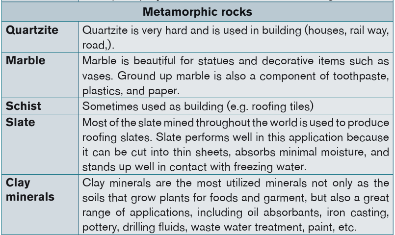
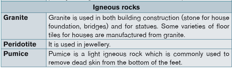
B) Disadvantages of rocks on the landscape and man
– Hard and resistant rocks hinder the penetration of plant roots hence,
limiting the weathering process or hindering the growth of vegetation;
– Rock forming minerals have different colours. The difference in colours
makes minerals to absorb differently the heat. Dark-coloured minerals
absorb much heat during daytimes and therefore expand, causing the
cracking and fragmentation of rocks.
– The sand can blow; rocks can roll risking injury to people;
– Light-coloured rocks reflect sunlight and increase the temperature
around the plants during the daytime;
– Some environments such as sand rocks (dunes, erg, etc.) are not
suitable for human settlement because of lack of water and soils;
– Some rocks may reflect landscape with steep slopes where human
activities such as agriculture or settlement cannot be possible.
Application activity 5.2
1) Referring to the properties of rocks, explain how rocks react to the
stress and the resulting landscapes?
2) Analyse a sedimentary rock in your local environment and describe
the process under which it might have been formed.
3) With relevant examples, discuss the disadvantages of rocks onlandscape and society.
5.3. Minerals
Learning activity 5.3
1) Account for the types and characteristics of minerals.
2) Examine the use of minerals to your society.
5.3.1. Definition, types and characteristics of a mineral
A mineral is a solid inorganic substance that occurs naturally in the earth’s
crust. A mineral deposit is a concentration of naturally occurring solid material
in or on the earth’s crust. Mineral resources are non-renewable.
There are five characteristics shared by all minerals.
– All minerals are formed by natural processes. They can form when
magma cools, when liquids containing dissolved minerals evaporate, or
when particles precipitate from solution.
– Minerals are inorganic. They are not alive and are not made by life
processes. Coal, for instance, is made of carbon from living things.
Although geologists do not classify coal as a mineral, some people do.
Miners, for example, generally classify anything taken from the ground
that has the commercial value as a “mineral resource”.
– Minerals are solid and have a definite volume and shape. A gas such
as air and a liquid such as water aren’t minerals because they do not
have definite shape.
– Every mineral is an element or a compound with a chemical
composition unique to that mineral.
– The atoms in a mineral are arranged in a pattern that is repeated
over and over again.
The table below shows two examples of mineral crystals (salt and quartz) with
defined shapes:Examples of mineral crystals with defined shapes

5.3.2. Types of minerals and ores
The wide varieties of minerals that have been explored by man for general and
commercial purposes to satisfy his needs are of two types: metallic mineralsand non-metallic minerals.
1) Metallic minerals
Metallic minerals include:
– Industrial metallic minerals: iron ore
– Ferroalloy metallic minerals: manganese, chromium, cobalt, molybdenum,
vanadium, nickel.– Precious metallic minerals: gold, silver and platinum
2) Non-metallic minerals
This category of non-metallic minerals includes salt, tin, potash, asbestos and
sulphur.
Rocks or minerals worked because they contain valuable (profitable) elements
are usually called ore-deposits. Minerals are extracted in a mineral ore. For in
stance, Aluminum comes from the ore bauxite. The iron comes from the mineral
ore Hematite. A mineral can also be called an ore, for example Hematite is a
mineral that can also be called an ore. A mineral is an ore if it contains useful
substance that can be mined at a high profit and be processed and refined into
more useful materials. For instance, Aluminum can be refined from bauxite, and
made into the useful products. These products are worth more money than thecost of the mining, so bauxite is an ore.
5.3.3. Physical properties of minerals
The most common minerals in earth’s crust can often be identified in the field
basing on their basic physical properties such as their form, hardness, fracture,
cleavage, colour, streak, density, luster, mass, taste, odour, feel, magnetism as
described below:
1) Form: Definite geometrical forms called crystals can be recognized
in minerals. These are for example: cubic, acicular (needle shaped),columnar, fibrous, reniform (kidney shaped) and nodular forms.
Pyrite (left) has a cubic form; Tourmaline (middle) is prismatic; azurite and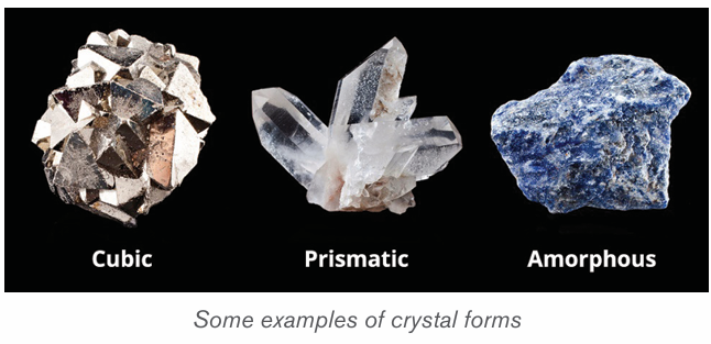
malachite (right) are often amorphous.
2) Hardness: The hardness of a mineral can be tested in several ways.
Most commonly, minerals are compared to an object of known hardness
using a scratch test developed by Friendrich Mohs. He assigned integer
numbers to each mineral, where 1 is the softest and 10 is the hardest.This scale is shown below.
If the gem minerals are excluded, the scale has only 7 numbers. Substitutes may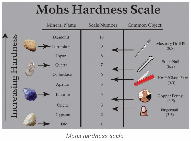
be used when the scale minerals are not available:
– Easily scratched by nail;
– Not so easily scratched;
– Can be scratched by a piece (a copper coin);
– Scratched easily by knife;
– Can be scratched by knife with difficulty;
– Scratched by window-glass;
– Window-glass is scratched by the mineral.
3) Fracture: Freshly broken surfaces of minerals present characteristic
fracture surfaces. The following important types are noted:
– Conchoidal (vitreous): the fracture surfaces are curved with a concave
or convex form; for example, quartz.
– Even: the fracture surfaces are nearly flat; for example, in chert.
– Uneven: the fracture surface is formed of minute elevations and
depressions; for example, most of minerals.
4) Cleavage: This is how the mineral breaks. Certain minerals split easily
along certain planes called cleavage-planes. These planes are parallel
to certain faces of the mineral crystal, or to faces of a form in which the
mineral may crystallize.
5) Colour: When a body absorbs all the seven colours that make up white
light it appears black, and when it reflects all the colours it appears white.
When a body reflects the green vibrations of white light and absorb the
other vibrations it appears green. Thus, the colour of a body depends on
the selective reflection and absorption of the different vibrations of white light.
6) Streak: The colour of the powder of minerals sometimes differs from
the mineral in mass. Different specimens of the same mineral might show
variation in colour, yet the streak is fairly constant.
7) Luster: The amount and the type of reflection from the surface of a
mineral determine its brightness.
8) Mass: The mass of a mineral can be used to identify its type.
9) Density: The density of a mineral can also be used to determine its type.
10) Taste: Some of the minerals which are soluble in water give distinctive
taste but the character is not very useful in identification of minerals
because there are only a few minerals which are soluble is water. For
example, we get a saline taste in case of common salt, and alkaline in
case of soda or potash.
11) Odour: Only a few minerals give characteristic odour, e.g. the odour of
garlic from arsenic compounds.
12) Feel: Minerals differ in the sensation they give by touch, e.g. minerals are
smooth, greasy or rough.
13) Magnetism: Generally, iron bearing minerals are magnetic, but not
necessarily all iron bearing minerals are magnetic. Some non-magnetic
minerals like monazite are also slightly magnetic. The electromagnetic
minerals depend on the varying magnetism of different minerals.
5.3.4. Chemical properties of minerals
Some minerals are affected by the variations in temperature and the pressure on
the earth’s surface. Others vary in the structure depending on the percentage of
water that they loose with the change of the temperature and the pressure. The
chemical composition influences the destruction of the rocks and development
of new minerals.
Chemical properties of minerals are identified from their chemical composition.
We refer to two elements that are Silicon and oxygen. These are the two most
abundant elements in the earth crust. They constitute approximately 90% of
the crust of the earth. Then we distinguish silicate minerals and non-silicate
minerals. Silicate minerals (silicates) are minerals containing Silicon and Oxygen
atoms usually with one or more other elements. Non-silicates are minerals otherthan silicate minerals.
Chemical properties of minerals
5.3.5. The importance of minerals and manufactured products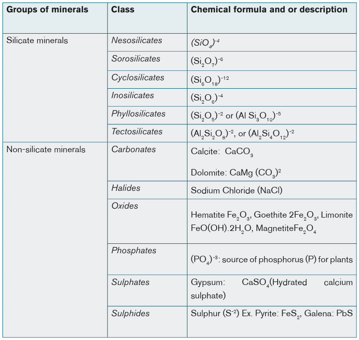
Minerals provide the material used to make most of the things of industrial-based
society; roads, cars, computers, fertilizers, etc. In more than 1600 minerals
identified in earth crust, only 200 are extracted for commercial and industrial
purposes and less than 1/3 are the most economically significant.
Some minerals have high economic value because of their uses or they are rare
and beautiful. For example, germs or Gemstones is a mineral with a distinctivecolour which makes it expensive. That is why it is used for jewellery.
The table showing manufactured products from minerals
Application activity 5.3
1. What are the five characteristics shared by all minerals?
2. Differentiate a mineral from an ore.
3. Identify minerals that are extracted in your district and describe theiradvantages and disadvantages.
Skills Lab
Show how you are going to use available rocks for the economicimprovement of your society.
End unit assessment
1. Classify the different types of rocks and their characteristics.
2. Evaluate the economic importance of rock and minerals in your society.3. Identify the physical and the chemical properties of the minerals.
UNIT 6 : CLASSIFICATION OF SOILS AND SOIL FORMATIO
Key Unit competence
By the end of this unit, I should be able to explain the classification of soilsand factors responsible for the formation of the soil.
Introductory activity
Read the passage below and answer the questions that follow:
Soil is defined as the thin layer of material covering the earth’s surface and
is formed from the weathering of rocks. It is composed of mineral particles,
organic materials, air, water and living organisms all of which interact slowly
but constantly.
Most plants get their nutrients from the soil and they are the main source
of food for humans, animals and birds. Therefore, most living things on land
depend on soil for their existence.
Soil is a valuable resource that needs to be carefully managed as it is easily
damaged, washed or blown away. If we understand soil and manage it
properly, we will avoid destroying one of the essential building blocks of ourenvironment and our food security.
1. Identify major types of soil in the world
2. Describe factors responsible for soil formation
3. Assess the importance of soil to man
4. Discuss the major causes of soil erosion and suggest what shouldbe done to prevent it
6.1. Definition of the soil
Soil is a dynamic natural body capable of supporting a vegetative cover. It
contains chemical solutions, gases, organic refuse, flora, and fauna. The physical,
chemical, and biological processes that take place among the components of asoil are integral parts of its dynamic character.
6.2. Classification of the major types of soil in the world,
factors and processes of soil formation
This section presents briefly the classification of the major types of soil in theworld, factors and processes of soil formation are briefly described.
Learning activity 6.1
1. Make research on the major types of soils in the world.
2. Identify factors influencing soil formation3. Discuss on processes leading to the formation of the soil
6.2.1. Classification of the major types of soil in the world
The classification of soils is either based on geographic regions, where
the soils are well-developed from the parent material by the normal soil
forming action of climate and living organisms. Another way of classifying
the soil is based on the level of weathering, which is related to geographic
environments, but also under the same geographical region you can finddifferent types of soils which reflect the level of weathering.
A) Soil classification based on geographical regions
The soil classification based on geographical regions, include three soil
classes: zonal soil, intrazonal soil and azonal soil.
i) Zonal soils
These are soils that cover a wide geographic region in the world. They depend
on the major climatic zones, vegetation and living organisms in areas where the
landscape and climate have been stable for a long time. They are common on
gentle slopes. They are found both in tropical and temperate regions.
This kind of soil has the following types: Tundra Soils, Podzols, Brown forest
Soils, Lateritic Soils / Latosols / Ferralsols, Chernozem / Prairie / Steppe,
Grumusol / Reddish Brown Soils, Desert (Seirozems and Red Desert) Soils.
ii) Intrazonal soils
These are soils that mainly develop due to relief of the area and the nature of
parent rock. These soils reflect the dominance of a single local factor, such as
parent rock or extremes of drainage that prevail over the normal soil-forming
factors of climate and living organisms. They are divided into three types:
• Calcimorphic or calcareous soils which develop on limestone
parent rock (rendzina and terra rossa);
• Halomorphic soils which contain high levels of soluble salts (e.g.
sodium ions) which render them saline.
• Hydromorphic soils that have constantly high water content which
tends to suppress aerobic factors in soil-formation.
iii) Azonal soils
Azonal soils have a more recent origin and occur where soil-forming processes
have had insufficient time to operate fully. They lack well-developed horizons
because of immaturity or other factors that have prevented their development
such as excessive soil erosion. They are skeletal soils resulting from erosion and
deposition. They lack clear soil horizons. They are common in volcanic regions,
glaciated regions and areas blown by winds. They include dry sand, loess,
moraine soils, and marine soils, alluvial and volcanic soils.The map below shows the major soil types of the world
B) Soil classification based on level of weathering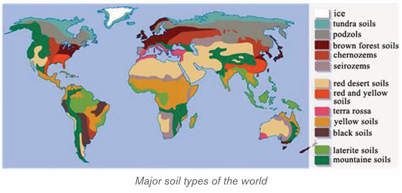
Basing on the level of weathering, the American soil taxonomy has classified
soils into 12 soil orders which reflect the level of weathering (slight, intermediateand strong) plotted on the chart and briefly described below:
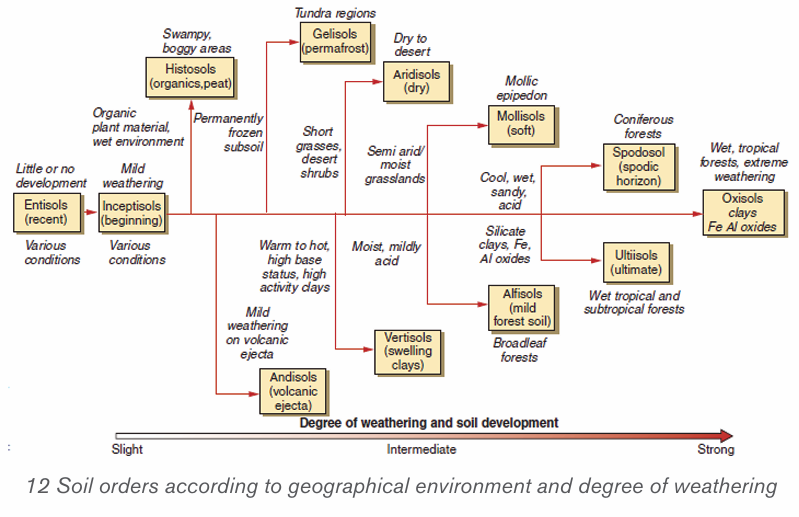
Table: Major soil orders according to American classification
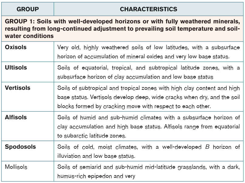
6.2.2. Soil formation factors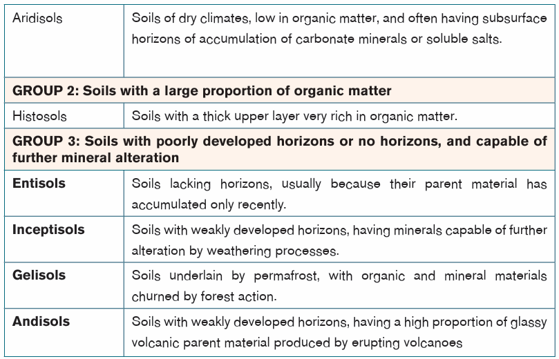
Soil formation is a function of five factors which include parent material,
climate, biology (living organisms), relief (topography), and time. They are
classified passive (parent material, relief “topography” and time) and dynamic
(climate and biology “living organisms)”. Recent studies have shown that human
activities can have an impact on soil development. These factors interact as asystem to form soils. The roles of these factors are briefly hereafter described:
Parent rock
Physical and chemical weathering of rocks in the upper lithosphere provides
the raw mineral ingredients for soil formation. This helps to determine the type
of soil, mineral composition and texture. For instance, granite and sandstone
disintegrate to form sandy soils rich in quartz, volcanic lavas form clay soils withlow quartz content and plants decompose to form loam rich in humus.
Climate
The moisture (rainfall), evaporation and temperature changes determine the
chemical reactions and physical breakdown of rocks. Climate also affects rate
and type of weathering. For example, heavy rainfall results into deep soils due
to heavy weathering and leaching, wind in deserts is responsible for formationof loess soils.
Living organisms
Plants, animals and microbes are living organisms that affects soil development.
Dense vegetative cover protects a soil from being eroded away by running water
or wind. . Burrowing animals and worms mix organic remains with mineral soil
component. - Roots penetrate and add more porosity, improve soil depth and
aeration. Micro-organisms such as bacteria cause plant and animal remains todecay into humus
Topography
The topography represents the slope of the relief. The slope of the land and its
aspect (the direction it faces) all influence soil development. Steep slopes are
generally subject to rapid surface runoff of rainfall and less infiltration of water,
whereas on gentler slopes runoff decreases with an increasing infiltration. As a
consequence, rapid runoff on steep slopes can erode soils as fast, or faster
than soil can develop on them. Steep slopes result in shallow immature soils
due to severe erosion and prevent the formation of a soil that would support
abundant vegetation,
On gentler slopes there is higher infiltration and less runoff. More water is
available for soil development and to support vegetation growth, so erosion is
not as intense. Well-developed soils typically form on land that is flat or has agentle slope.
Time
All of the mentioned above natural factors in soil development require time to
operate. This determines the depth of weathering and the period of operation
of soil formation processes. Briefly, the longer the time taken by soil formingprocesses the deeper and well developed soil is.
6.2.3. Processes of the soil formation
The formation of soil requires numerous processes. Soil is said to be formed
when organic matter has accumulated and colloids are washed downward,
leaving behind deposits of clay, humus, iron oxide, carbonate, and gypsum,producing a distinct layer called the ‘B’ horizon.
Weathering: Weathering is the process by which the rocks break down into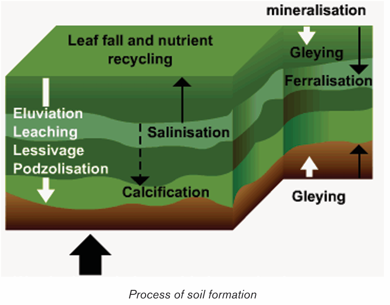
small particles to form soil. It is the combined action of physical weathering, in
which rocks are fractured and broken, and chemical weathering, in which rock
minerals are transformed to softer or more soluble forms.
Mineralization: This is the process through which organic matter is further
decomposed into mineral compounds. Mineral content in humus may be further
converted to inorganic matter e.g. silica.
Humification: Humification is the process by which organic matter is
decomposed to form humus, a task performed by soil organisms.
Eluviation: Eluviation is the downwards movement of fines particles such as
clay and the leached soluble materials from upper layers of the soil (‘A’ horizon)
to another lower layer within the soil.
Illuviation: This is the process of accumulation of clay, aluminum and iron
usually from A and E horizons to B horizons.
Leaching: Leaching is the removal of soluble material in solution. It is the
process by which water removes leached materials (organic and inorganic) in
solution from the upper horizon to the underlying horizon. It operates vertically
but not sideways.
Laterization: Laterization is leaching of soils in warm and humid climates. It is
a process that occurs after the soluble mineral substances have been leached.
After leaching, the insoluble mineral compounds derived from the parent rock
remain on top, hence forming lateritic soils that are stony.
Calcification: This is the process in which calcium carbonates accumulates in
the ‘B’ horizon; particularly characteristic of low rainfall areas such as arid andsemi-arid climates.
Application activity 6.1
1. Soil forms continuously, but slowly, from the gradual breakdown of
rocks through weathering:
a. Explain how organisms contribute to the formation of soil
b. Describe any three other processes leading to the soil formation
2. With reference to the knowledge and skills you have acquired in this
unit, discuss the difference between zonal soils, azonal soils and
intrazonal soils.
3. Based on the level of weathering, describe the soils orders accordingto American soil classification
6.3. Soil erosion: causes, effects, appropriate soil
management and the conservation measures and importance of soil
Learning activity 6.3
1. What does soil erosion means?
2. Identify major causes of soil erosion3. Discuss on the effects of the soil erosion
6.3.1. Cause of soil erosion
The predominant causes of soil erosion are either related to naturally occurring
events or influenced by the presence of human activity. If we want to prevent
soil from going away, we need to understand different factors contributing to
the soil erosion. Some of the major causes of soil erosion include:
– Overgrazing also causes excessive loss of water from the soil causing
it to become loose and fine grained and easily eroded.
– Rainfall: In a particular heavy rain result to excessive soil erosion and
thus poorly aerated
– Drought: A long dry weather deprives the soil of moisture which holds
the soil together causing particles to loosen making it to be easily
brown by wind.
– Some human works in relation with excavation activities such as
quarrying, open-cast mining, building of estates and road construction
which loosen and expose the soil to erosion agents.
– Slope of the landscape: The physical characteristics of the land can
contribute to the soil erosion. For example, steep slopes accelerate
soil erosion while gentle slopes experience less erosion, places with
rugged terrain experience gulley erosion while hilly and steep areas
experience rill and gulley erosion.
– Poor cultivation techniques such as pulling hoe along the surface
when removing weeds which loosens the soil and when it rains it’s
washed away, ploughing of land down slope which accelerates
soil erosion, cultivation of steep slopes and along river banks which
encourages soil erosion, burning which destroys vegetation coveringthe soil exposing it to erosion agents etc.
6.3.2. Effects of soil erosion
Some of the greatest effects of soil erosion include:
– Loss of topsoil: Soil erosion lowers the agricultural productivity of
land when fertile top soil is eroded.
– Desertification: Soil erosion contributes to desertification when top
soil is eroded leaving bare ground destroying vegetation.
– Water pollution: Serious soil erosion is responsible to water pollution
when agro-chemicals and other chemicals are carried to rivers, lakes
or oceans.
– Flooding: Another effect of soil erosion is that it contributes to flooding
by blocking river channels causing them to burst their banks during the
rainy season flooding the adjacent areas.
– Alteration of the landscape: Soil erosion can cause significant
alteration to the natural shape of the land. For example, it can make
huge valleys to occur on plain lands.
– Reduced organic and fertile matter: Removing topsoil that is heavy
with organic matter will reduce the ability for the land to regenerate newflora or crops.
– Eye and respiratory problems: Soil erosion especially one caused
by wind can cause eye and respiratory problems. The latter can happen
when people inhale the dust and soil particles being carried away by
the wind into their lungs. Eye problems can also occur when the dust
particles from wind erosion enter into the eyes.
– Water siltation: Persistent soil erosion causes siltation of water
reservoirs reducing their utility. For example, H.E.P. generation,
navigation and fishing
– Destruction of properties: It may cause collapsing of structures such
as buildings and bridges when soil around them is eroded weakeningtheir foundation.
6.3.3. Appropriate soil management and the conservation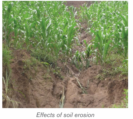
measures
Generally, when it comes to finding solutions for soil erosion, the most useful
techniques found tend to be those that highlight reinforcing the structure of the
soil, and reducing processes that affect it.
– Careful tilling: Due to the activity of preparing land for growing that
involves break up the structure of the soil, doing less tilling with fewer
passes will preserve more of the crucial topsoil
– Crop Rotation: If farmers want to keep their land happy and healthy,
they are strongly advised to apply crop rotation. Growing crops which
require different nutrients on the same piece of land on rotational basis
to prevent exhaustion of particular mineral nutrients from the soil.
– Mixed farming: This involves growing crops and keeping animals on
the same farm. Consequently, manure from animals is used to enrich
the soil with minerals and improve its structure.
– Increased knowledge: another major factor for preventing soil
erosion is education more and more people who work with the land on
why it is a concern, and what they can do to help reduce it.
– Contour Ploughing: Ploughing across the slope rather than down
the slope. This practice helps to trap water on horizontal furrows thus
preventing excessive soil removal.
– Terracing: Through dividing the slope into a series of wide steps, crops
can be grown on them. This helps to trap the soil from being carried
away by running water and also traps water allowing it to gradually
infiltrate into the soil.
– Afforestation and reafforestation: Vegetation play a big role in
preventing soil erosion:
• Leaves reduce the force of rain drops preventing soil particles from
being removed.
• Plants protect the soil, more dense plant cover yields less damage
from erosion.
• Vegetation increases the rate of infiltration of rain water into the soil
thus reducing runoff.
• Roots bind the soil particles together.
• Decayed vegetation provides humus which binds the soil particles
together.
– Planting wind breakers: Planting hedges or trees around plots in
large fields acts as wind breakers and also trap soil being carried by
water.
– Regulating livestock numbers: Matching the number of animals
kept to the carrying capacity of land.
– Paddocking: Overgrazing can also be prevented by paddocking which
ensures there is always pasture for animals and no area is overgrazed.
– Constructing Gabions: Construction of wire mesh boxes which are
filled with soil. This allows water to pass through but trap the soil then
vegetation gradually grows on the trapped soil.
– Planting Cover Crops: Planting crops which cover the soil properly
and holds the soil in place e.g. sweet potato vines.
– Mulching: This practice consist of covering the soil with crop residues.
• It helps reducing the impact of rain drops on the soil.
• Decays enriching soil with nutrients.
• Reduce the rate of moisture evaporation from the soil.
6.3.4. Economic importance of the soil
– Soil provides physical support for the rooting system of plants and
protects root system from damage.
– It is a conducive habitat for burrowing animals and bacteria necessary
for breakdown of organic matter into humus.
– Soil acts as a medium through which nutrients and air are made available
to plants.
– It provides mineral elements to plants e.g. nitrogen, calcium, phosphates, etc.
– Serve as a construction material for building and other infrastructure.
Example, clay is used for making bricks and tiles.
– Clay soil is used in ceramics such as making pots.
– Source of minerals especially to expectant mothers.
– Soil contains valuable mineral elements such as alluvial gold.
– Soil supports plant life which is a source of food for people and animals
especially herbivores. Soils are used for medicinal purposes e.g. clayis mixed with some herbs for medical purpose in some communities.
Application activity 6.3Study carefully this photograph and answer the questions that follow
1. Suggest what could be the cause of the colored river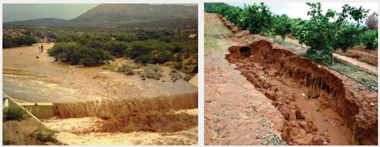
2. Examine the effects of soil erosion
3. If you had a chance to become a chairperson in charge of environmentalconservation, what would you suggest to handle the above cases?
Skills Lab
Identify any area affected by soil erosion and explain to the local peoplewhat should be done to slow down the washing away of soil.
End unit assessment
1. With reference to your knowledge and skills, show difference
between three categories of the soil in the world.
2. Explain how soil erosion is one of the major problem challenging
agriculture.
3. Soil is one of the amazing products of nature and without which
there would be no life. Justify
4. Most farmers in the northern province of Rwanda use terracing as a
measure of soil conservation.
a. Explain why terracing is mostly used in this area.
b. Describe other soil conservation techniques used in your area.
c. Show how these techniques are helpful to environmentalsustainability.
UNIT 7: CLIMATE CHANGE
Key Unit competence
By the end of this unit, I should be able to discuss the climate change and
its impact on Rwanda and the other countries
Introductory activity1) Using internet research and other geographical materials make a
research to establish relationship between the following concepts:
i) Climate change and global warmingii) Green house phenomena and desertification
2) Basing on the knowledge acquired from the question 1, assess the
consequences of climate change on Rwanda.
3) Which area of Rwanda is likely to experience the desertification?
Give reasons supporting your answer.
7.1. Climate change: definition, causes and effects
Learning activity 7.1
Study carefully the below photographs and answer the questions
that follow: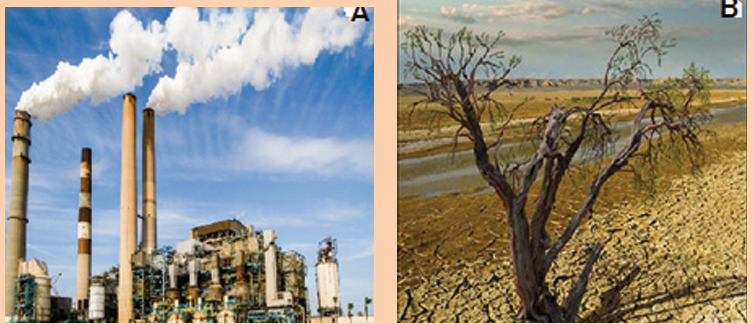
1) What does climate change mean?
2) Explain how industries contribute to the climate change?
3) Describe the effects of climate change
7.1.1. Definition of climate changeClimate change refers to the long-term changes in average conditions and
characteristics of earth’s lower surface atmosphere resulting either from natural
variability or human activities that change atmospheric conditions of a region or
location. It is also defined as a long term change of climatic elements such as
temperature, rainfall, wind speed and direction, sunshine, atmospheric humidity,
atmospheric pressure, cloud cover over a given region of earth’s lower surface
atmosphere or globally.
7.1.2. Causes of climate change
The causes of climate change are classified into natural causes and man - made
causes
i) Natural causes of climate change
Natural causes of climate change include:
Variations in the earth’s orbital characteristics
The more elliptical orbit makes the earth to be once year in closest position to
the sun (Perihelion: 147 500 000 km) or in farthest position to the sun (Aphelion:
152 500 000 km). At the Aphelion, the earth receives the least solar energy
while the maximum is received at the Perihelion.
Volcanic eruptions
Volcanic activity affects the climate. World temperatures are lowered after a
series of volcanic eruptions. This is due to the increase in dust particles in the
lower atmosphere which will absorb and scatter more of the incoming radiation.
Sulphur dioxide gas is given off during some of the eruptions. This gas remains
in the atmosphere for as long as three years and it reacts with water vapor
and forms a bright layer in atmosphere. This layer reduces the amount of solar
radiation reaching the earth surface by reflecting some back to universe.
Variations in solar output
Sunspot activity which occurs in cycles, may significantly affect our climate.
Times of high annual temperatures on earth appear to correspond to periods
of maximum sunspot activity. The results found from satellites measurements
showed a decrease of 0.1% of the total solar energy coming to the earth in the
early 1980s. This value was obtained over a period of 18 months. It is predicted
that the increase in solar output of 1% per century will contribute to the increase
of the global average temperatures by between 0.50C and 10C.
Variation of aerosols in atmosphere
Aerosols like solid particles of varying sizes and liquid droplets which include:
ploughed soil cover, deserts, rocks, salt particles from seas and oceans;
meteoric particles, organic matter, such as bacteria, seeds, spores and pollen.
These particles help in selective scattering of shortwave electro-magnetic solar
radiation which adds varied color of red and orange at sunrise and sunset. Some
of the aerosols, mainly water droplets, absorb certain amount of solar radiation
while some amount of radiant solar energy is reflected back to the space. The
high concentrations of aerosols in atmosphere decrease the temperatures to
reach the earth surface.
Sunspots
Sunspots, defined as dark areas within photosphere of the sun and surrounded
by chromosphere, are created in the solar surface (photosphere) due to periodic
disturbances and explosions. These dark areas are cool areas because they are
characterized by 1, 5000C less temperature than remain part of photosphere.
The increase or decrease in number of sunspot is completed in a cycle of
11 years. It is believed that the energy radiated from the sun increases when
the number of sunspots increases and consequently the amount of insolation
received at the earth’s surface also increases.
ii) Human causes of climate change
Human activities have been the mostly responsible for atmospheric alterations.
Human activities participate highly in atmospheric pollution leading to the
change in composition of atmosphere.The atmosphere is polluted by human activities in the following ways:Variations of carbon dioxide in atmosphere
Carbon dioxide (CO2 ) is an important heat-trapping (greenhouse) gas. Itis released through human activities such as burning fossil fuels and gases
released from industries, as well as natural processes such as respiration and volcanic eruptions. There is a positive relationship between the concentration of
carbon dioxide in atmosphere and the global temperatures: high concentrations
of carbon dioxide result to the rise of temperature on the earth surface while low
concentrations of carbon dioxide result to the lower temperatures.
Forest and grassland fire
It increases the concentration of carbon dioxide in atmosphere resulting from
the burn of trees and grassland which are cut and put under fire for different
purposes.
Deforestation and land use changesWhen people clear large areas of forests and grasslands for cooking or
construction, they reduce the main disposal system for carbon dioxide from
atmosphere by photosynthesis, which leading to the increase of carbon dioxide,
and eventually to the increase of temperature on the earth surface.
Industrial developments
Gases like methane, nitrous oxide, chlorine, bromine and fluorine are added into
the atmosphere through industrial activities.
Industrial waste and landfills
Industries which are involved in cement production, fertilizers, coal mining
activities, oil extraction produce harmful greenhouse gases. Also, landfills filled
with garbage produce carbon dioxide and methane gas contributing significantly
to greenhouse effect.
UrbanizationThe buildings of cities increase the reflection and decrease the absorption of
solar radiation which would change the temperatures on the earth surfaces. The
urban activities participate also in increasing the concentrations of greenhouse
gases in atmosphere leading to the rise in temperature.
Increase in Population
It is obvious that this last two decades the people have been huge increase in
the population. Now, this has resulted in increased demand for food, cloth and
shelter. New manufacturing hubs have come up cities and towns that release
some harmful gases into the atmosphere which increases the greenhouse
effect. So, more people means more usage of fossil fuels which in turn has
aggravated the problem.
FarmingNitrous oxide is one the greenhouse gas that is used in fertilizer and contributes
to greenhouse effect which in turn leads to global warming.
7.1.3. Effects of climate change in the world (global, Africa, Rwanda)i) Effects of climate change in the world
The following are the effects of climate change in different parts of the world:
Increase in the amount of rainfall: A rise in global temperatures could leadto an increase of evapotranspiration. This could eventually lead to the rise in
amount of rainfall.
Melting of glaciers: A rise of temperature leads to the melting of glaciers inpolar and mountainous regions resulting into flooding. This would cause the
levels of the sea to rise by 20 cm by the year 2030.
Rise in the sea and ocean levels: The increase in the amount of rainfall andmelting of glaciers leads to the increase of the sea and ocean levels destroyingboth human and physical features at the coast.
Increases in intensity of extreme weather: Climate change increasesevents such as heat waves, tornadoes and hurricanes.The prolonged severe droughts: Some regions may experience prolongeddroughts caused by reduction in rainfall, which may result in aridity.Depletion of ozone layer: High amount of harmful ultraviolet radiationincreases the cases of animal and human diseases such as cancers, blindness
and other eye diseases.
Occurrence of acid rain: Acid rain is harmful to animal and human being.
Lower crop and timber yields: Since ultraviolet radiation slows down manyaspects of plant growth such as photosynthesis and germination in many plants
leading to low production.
Reduction of plankton growth: As temperature goes beyond coral reefsliving standard, fish breeding and feeding patterns are disrupted.
Decrease of agricultural production: In some regions, the rainfall maydecrease, or agriculture seasons be disrupted because of climate change.
Some regions became drier and make soil infertile for crop production.
City environments becoming warmer: The increase of carbon dioxidemakes the temperatures to increase most in urban areas.Water use and long-term planning: A wetter or drier climate can affectwater resources planning. Water reservoirs, dams, and hydroelectric projects
might become useless in coming years.
Spread of vector-borne diseases: Because of high temperature there canbe an increased range of insects.
Acidification of oceans: This can create a reduction in plankton, coral reefs
and a drop-in fishing yield.
ii) Effects of climate change in AfricaThe following are some of the facts showing the climate change and variability
in Africa:
– Melting of glaciers on the top of the highest African mountains such as
Kilimanjaro, Rwenzori, Kenya and Karisimbi;
– Warming in African tropical forests has been evaluated at 0.29 °C for
the past 10 years and 0.1 °C to 0.3 °C in South Africa, while it ranged
between 0.2 °C and 0.3 °C in the Nile Basin countries;
– Decreasing trends in temperatures; in eastern Africa, the situation has
been complex because they have been observed over the regions
close to the coast or major inland lakes and increasing in the rest of
the region;
– The gradual heating, between 1961 and 2000, over the continent
meant more warm spells (days) and fewer cold days across Africa.
An increase in temperature in Sahara desert has led to the decline in
volume of water in Lake Chad;
– Fluctuations of precipitation; the extent of variability is complicated and
exhibits more spatial and temporal fluctuations across the continent;
– The decrease in rainfall has been registered in West Africa (between 4 °
and 20 °North; 20 °West and 40 °East), by up to 20% to 40% for the
periods 1931-1960 and 1968-1990 respectively. A similar decline in
mean annual rainfall has also been observed in the tropical rain-forest
zone. A reduction of around 4% in West Africa, 3% in North Congo
and 2% in South Congo for the period 1960-1998.;
– Increases in rainfall have been registered in different parts of southern
Africa (e.g., Angola, Namibia, Mozambique, Malawi, and Zambia);
– Increase in the desertification in south of the Sahara desert;
– Links have also been identified between the warm Mediterranean Sea
and abundant rain fall over the surrounding regions.
iii) Effects of climate change in Rwanda
Rwanda experiences some rainfall events that cause unexpected flooding and
catastrophic events such as landslides etc. These extreme events are attributed
to climate change. The figure below represents some effects of extreme rainfall
events of climate change in Rwanda.
The following are effects of climate change in Rwanda:
– Significant increase in precipitations at a rate of between 2 and 6.5 mm
per year over the Congo-Nile crest and the northern highlands for the
period of 1935–1992.
– Floods that occurred in May 2002 caused the death of 108 persons in
North western regions while the one occurred in 2007 have resulted to
displacement of more than 456 families and destruction of hundreds of
hectares of crops in Bigogwe sector in Nyabihu District;
– During September 2008 heavy rainfall accompanied by winds affected
8 of the 12 sectors of Rubavu district and provoked the displacement
of more than 500 families, caused the destruction of about 2,000
hectares of crops and many other infrastructures;
– Floods reported in September 2012 in Nyabihu, Rubavu, Bugesera
and Kirehe districts whereby more than 1000 families were displaced
and their crops submerged completely;
– The landslides and floods caused by heavy rainfall are regulary observed
mainly in north- western parts of Rwanda (Rulindo, Gakenke, Musanze,
Nyabihu and Rubavu districts). For instance, the floods which occurred
on 2nd and 3rd April, 2016 caused the death of 12 people, with 19
injured and destruction of 196 houses across the country. The floods
which took place in Musanze district on 20th April 2016 caused the
destruction of 64 houses and many hectares of crops and cattle;
– The significant increase in mean annual temperatures of between 0.036
and 0.066 °C per year for the period of 1961-1991;
– Since 1902, a number of famines following prolonged droughts
episodes have been registered in Rwanda notably in eastern and
south-eastern regions;
– More occurrences of lightning combined with the thunderstorms in
2013 caused 12 deaths in Karongi, 12 in Rubavu, 4 in Rusizi and 5
death in Rutsiro districts, respectively. The same districts suffered from
the same extreme weather events which were reported to cause 15
deaths in 2015 (January-October) with 30 people injured.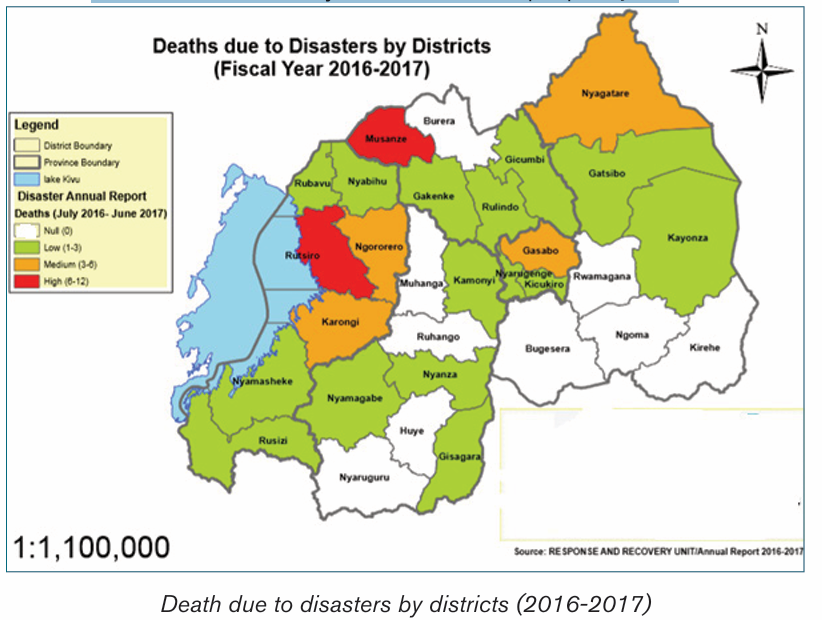
Application activity 7.1
1) Identify the areas of Africa that are susceptible to face the climate
change challenges?
2) Describe the effects of climate change in Eastern and Western
provinces of Rwanda.
7.2. Global warming and the green house phenomena(definition, causes and the effects)
Learning activity 7.2
1) Use different resources to find the meaning of the following:
i) Global warmingii) Green house phenomena
2) Explain the reasons of practicing greenhouse farming.
7.2.1. Definitions of global warming and greenhousephenomena
These two phenomena of global warming and greenhouse are related but are
different.
i) Global warming
Global warming refers to the gradual rise in world temperatures. This is a gradual
increase in the average temperature of the earth›s atmosphere and oceans due
to increase in the amount of carbon dioxide. The increase in the amount of
carbon dioxide leads to greenhouse effect. It is a change that is believed to be
permanently changing the earth›s climate. An increase in greenhouse gases
increases the greenhouse effect which in turn increases the global warming.
In the last 100 years, the mean surface temperature on earth has increased by
0.5 °C.
i) Greenhouse effect
The greenhouse effect is a phenomenon in which the atmosphere of a planet
traps radiation emitted by sun. It is caused by gases such as carbon dioxide,
water vapor, and methane that allow incoming solar radiation to pass through
but retain heat radiated back from the planet’s surface.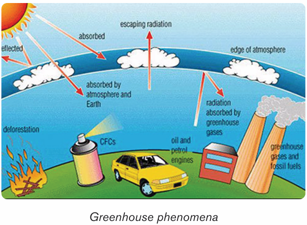
7.2.2. Causes of global warming and green housephenomena
The following are the causes of global warming and green house phenomena:
1) Human factorsHuman activities produce various gases ejected in the atmosphere that are
responsible for the global warming. These activities are destroying earth at fast
rate: the emission of carbon dioxide from industries and vehicles, the burning
of fossil fuels, cutting of trees and forests to build some new buildings and new
malls, dumping of trash everywhere and not even recycling it, excessive use of
the plastics and smoke from factories. All the activities performed by human
beings are the major factors for gases that pollute the air and warm up the earth.
These may contribute to the destruction of the ecological balance of the nature
leading to the global warming.
Burning of fossil fuels
Fossil fuels are burnt on day-to-day basis. This activity produces large
percentage of gases such as carbon, petroleum, coal and many other different
gases which are emitted in earth’s atmosphere. Carbon dioxide being one of
gases with greenhouse effect is provided in excess in our atmosphere in far
greater quantity in comparison with other gases produced by human activities.
Use of chemical fertilizersThe use of the artificial chemicals for crops has become one reason for the global
warming. These chemicals are dangerous to the earth as well as to the human
beings. These fertilizers are rich in the nitrogen oxide which is more dangerous
than the carbon dioxide. Those oxides of nitrogen destroy ozone layer even
faster than other greenhouse gas and hence let harmful ultraviolet rays enter
atmosphere thus making earth warm and leading to the global warming.
Industrial advancement
More and more different industries and factories are set up in modern world to
meet needs of the human beings. These factories need large amount of fuels like
some coal, petroleum for power generation and electricity required by machines
to work. Burning of these fuels also releases large amount of the carbon dioxide
which absorbs harmful radiations from sun making it warm, hence increasing
global warming.
Deforestation
The mass removal of trees, called deforestation, also affects the amount of
carbon dioxide in our atmosphere. Forests around the world are being cleared
for cultivation, mining, building, roads building, grazing cattle, etc. As they grow,
trees take in carbon dioxide. When trees are removed, the carbon dioxide that
they could have removed from the atmosphere is left. Cut-down trees are often
burned. Burning produces more carbon dioxide. If the trees are cut, plants will
not be able to produce oxygen and concentration of the carbon dioxide will
increase. Increase of the carbon dioxide in air is very harmful for the human beings
and also disturbs water cycle and hence total imbalance of our ecosystem. So
being one of greenhouse gases it will lead to the global warming.
Air pollutionThe harmful gases emitted from vehicles and the factories and greenhouse gases
cause some pollution in the air and these gases get captured in atmosphere.
The smoke gather up in atmosphere forming some clouds full of harmful gases
which later fall as the acid rain which destroys plants. Plants provide us with
oxygen and if they die level of carbon dioxide will increase in atmosphere which
is known as a harmful gas. These gases emit heat which increases temperature
of earth, hence causing global warming.
2) Physical factorsVolcanic eruptions
Volcanic eruptions are also among the causes of global warming. These eruptions
contain the dust particles and gases like the sulfur dioxide which stays in the
atmosphere for years and blocks the sunlight from reaching surface of earth
making it somewhat cool. These dust particles affect balance of atmosphere
and become contributing factor of the global warming.
Depletion of ozone layer
Depletion of ozone layers is an important factor that causes global warming.
The ozone layer is known as the layer outside the atmosphere which protects
surface of the earth from harmful ultra-violet and the infrared radiations causing
some dangerous diseases like the skin cancer. Ozone layer depletion is one
of causes of the global warming; entering of the harmful gases which helps
in heating up the earth but other greenhouse gases like the carbon dioxide
and methane that helps in heating up and tears up ozone layer making a hole
called “Ozone hole”. So, ozone layer depletes due to these gases which allowultra violet radiations to enter the earth’s atmosphere making it more warm than
normal and also affects temperature leading to the global warming.
7.2.3. Impact of greenhouse process on global warming
Greenhouse effect is a process in which the atmosphere of the earth traps
some of the heat coming from the sun and fails to radiate, making earth warming.
This is due to the burning fuels, cutting of trees, concentration of the heat on
earth is increased to some abnormal levels making the greenhouse effect as
one of the major causes of the global warming. Carbon dioxide, nitrous oxide
and methane are the greenhouse gases which help to keep earth warm. It is
natural phenomenon that takes place with adequate concentrations of some
greenhouse gases. When concentration of these gases rises then they disturb
climatic conditions, thus making earth warmer. These gases are not able to
escape and that causes the worldwide increase in temperatures. So balance of
the carbon dioxide and some other gases should be maintained so that it does
not become major reason for the global warming.
Application activity 7.21) Explain why causes of climate change and green house differ in rural
and urban areas.
2) Among the effects of climate mentioned above, which ones do you
observe in your local environment?
3) Referring to the greenhouse phenomenon, describe the advantages
and disadvantages of the farming practiced in greenhouse.
7.3. Adaptation measures and mitigation for the climate changeLearning activity 7.3
In your local environment, identify any evidence of climate change and
propose sustainable strategies to deal with it.
7.3.1. Adaptation measures for climate changeAdaptation for climate change refers to measures and strategies taken to
cope with climate change and variability. These measures vary from one domain
to the other like agriculture, livestock keeping, tourism, public health and
water management; from one climatic region to the other as dry, wet, hilly, flat,
depression, mountains, floodplains; from season to season as in dry and wet
seasons; and across diverse actors as private, public, national, international,
NGOs, local communities. Hence, adaptation measures are many and are not
homogeneous. Some of them are briefly described below:
Maintaining current ecosystems wherever possible: This impliesstrengthening, extending and in some cases refining global protected area
networks to focus on maintaining large blocks of intact habitat with a particular
emphasis on climate change.
Agro-forestry: This is a land-use system that incorporates trees in food cropfields. In other words, it is a combination of agriculture and forestry for more
diverse, profitable, productive and sustainable land use.
Progressive and radical terracing: This is used to reduce runoff, soilerosion and landslides. At the same time, terracing helps to improve soil
quality and moisture retention, especially in steep areas.
Soil fertility conservation: Practices like the use of manure, mulching,planting of leguminous crops help to improve soil fertility by increasing the
micro-organism composition in the soil.
Seed and grain storage: This involves collecting seeds and grains fromfarmers at post-harvesting season and releasing them within the timely agreed
periods.
The use of pesticides: It is a wide range use of compounds such asinsecticides, fungicides, herbicides, rodenticides, molluscicides, nematicides,
plant growth regulators and others to control pests, insects, fungi, weeds,
bacteria, rodents, all of which are harmful to crops.
Ecological pest management: This is the use of natural enemy dynamicsor environmental positioning (e.g. crop shading) to eliminate or reduce the
presence of pests.
The use of improved seeds and species: This is vital to improve cropproductivity.Crop varieties and diversification: This measure consists of integration ofdifferent varieties of crops and hybrids of a particular crop. Multiple cropping
aids in replenishing the soil and maintaining its fertility by ensuring that there
is a constant balance of nutrients by decreasing dependence and saturation
of any one product.
Land use consolidation programmes: This encourage farmers withadjacent lands to grow the same crop. This facilitates the provision of inputs
(e.g. seeds and fertilizers), post-harvest activities (e.g. driers, seed and grain
storage facilities) and safer and faster transport of agricultural products.
Rain water harvesting: It is the practice of collecting and storing rainwaterfrom rooftops, land surfaces or rock catchment areas for different use.Irrigation like drip irrigation is a practice based on the constant applicationof specific and controlled quantity of water to the crops. The system uses
pipes, valves and small drippers or emitters that transport water from the
sources (i.e. wells, tanks and reservoirs) to the root area and applying it in
controlled quantities and pressure specifications while Sprinkler irrigationinvolves spraying the crops with water using sprinklers in a manner that
resembles rainfall.
Wastewater use: It forms a reliable source for crop irrigation and a positiveway to dispose of sewage water. Whereas wastewater contains a lot of
nutrients on the one hand, it carries pollutants like micro and macro organic
and inorganic matters that potentially pose hazards to human health, the
environment, crops and soils, on the other.
Biotechnology of crops: It involves the practical application of biologicalorganisms, or their sub-cellular components in agriculture and livestock. The
techniques currently in use include tissue culture, conventional breeding,
molecular marker-assisted breeding and genetic engineering.
Barrier crops: These are crops that are used as a cultural control strategyfor reducing the spread of pests and diseases to the most vulnerable crops.
These crops provide benefits over “hard infrastructure” in a number of ways:
first, they offer a natural form of protection; second, they contribute to the
biodiversity and often soil improvement; third, they can provide an added
source of food provisions or income and, finally; they can play a determinant
role in soil erosion reduction.
Integration of meteorological information in agriculture: It is used todevelop early warning systems, crop monitoring and disaster management.Training farmers: By offering short courses, seminars and group discussionson the impacts of climate changes and on various ways of adaptation.Facilitating the farmers: this consists of facilitating farmers to accesscapital that they need to purchase seeds, installation of tube wells, drilling
of pumping sets, chemical fertilizers, plant protection chemicals, tractors,
harvesters, threshers and other accessories.
Development of infrastructure: This concerns the improvement oftransport networks, electricity and marketing facilities which use to be
affected by climate change phenomena to promote a sustainable livelihood
of population.
Development of agricultural institutions: The institutions such asuniversities provide experts and researchers who offer critical services
like assessment, promotion of agricultural and livestock innovations and
dissemination of research findings to agronomists and farmers at all levels.
7.3.2. Measures for mitigating the climate change
Mitigation measures for climate change consist of actions to limit the magnitude
and the rate of long-term climate change. Climate change mitigation generally
involves reductions in human (anthropogenic) emissions of greenhouse gases.
Anthropogenic greenhouse gases include carbon dioxide (CO2), methane(CH4), Nitrous oxide (N2O) and a group of gases referred to as halocarbons.The following are mitigation measures for climate change:
Storing and reducing carbon dioxide: Carbon dioxide can be captured and
stored, but also it can be reduced. Carbon dioxide Capture and Storage (CCS)
is a process consisting of the separation of CO2 from industrial and energy
related sources, transport to a storage location and long-term isolation from the
atmosphere. Conserving electricity is one strategy to reduce CO2.
When we conserve electricity, we reduce the amount of fossil fuel that must be burnt. One
way to save fuel is to change daily activities that rely on energy from burning
fuel.
Use of energy that reduces the atmospheric pollution: The use of
renewable energy supply technologies, particularly solar, wind, geothermal and
biomass are recommended to reduce the atmospheric pollution. Renewable
energy systems such as hydro-electricity can contribute as well to the security
of energy supply and protection of the environment.
Reduction of the energy use in buildings: Cooling energy use in buildings
can be reduced by different measures, for example reducing the cooling load by
building shape and orientation.
Land-use management: Forest land, cropland, grassland, wetlands,
settlements have to be well managed by fighting against any threaten to them.
Changes in land use may result in net changes in carbon stocks and in different
impacts on water resources.
Crop land management: The use of agricultural practices which promote
the conservation of water, and its quality. There is a need for improved crop
and grazing land management to increase soil carbon storage; restoration of
cultivated peaty soils and degraded lands.
Afforestation and reforestation: The increase of number of trees helps to
capture the CO2 and decreases the flow of water from catchments.
Solid waste management and waste water treatment: Controlled landfill
(with or without gas recovery and utilization) controls and reduces greenhouse
gas (GHG) emissions but may have negative impacts on water quality in the
case of improperly managed sites.
Application activity 7.3
1) If you were the Director General of REMA, demonstrate the adaption
measures to climate change in Rwanda.
2) Suppose that you are a manager of a big industrial complex, describe
the strategies to mitigate climate change.
3) Explain the process by which the use of refrigerator contributes to
climate change.
7.4. Desertification (definition, causes, effects)
Learning activity 7.4
Study the photograph below and answer the questions that follow:
1. Explain what happen in the area shown in the photograph.
2. Explain how climate change contributes to desertification.
3. Referring to the figure below, describe the challenges that face
people living in desert areas.
7.4.1. Definition of desertification
Generally, desertification is described as the turning of the land into desert. It
is the process by which the land undergoes degradation from which a relatively
dry land region becomes increasingly arid, typically losing its bodies of water as
well as vegetation and wildlife. Desertification is caused by a variety of physical
factors, mainly the climate change and human activities.
7.4.2. Causes of desertification
Desertification is caused by a combination of factors that change over
time and vary with location. These include the following:
Less rainfall (total amount) and increased drought (frequency and
intensity) lead to drought of rivers and water bodies and decrease in protective
vegetation cover.
Global warming: It causes higher temperatures and increased
evapotranspiration. This reduces condensation and leads to shortage of
rainfall.
Population growth: The effect of this is the over-cultivation which reduces
soil fertility and leaves the soil exposed to erosion.
Deforestation: An increased demand for cultivation land, wood for cooking,
heating, building, increases the risk of soil erosion.
Poor crop cultivation practices: Some farmers do not know how to use
the land efficiently. Farmers may essentially strip the land of everything that
it has before moving on to another plot of land. By stripping the soil of its
nutrients, desertification becomes more and more of a reality for the area that
is being used for farming.
Urbanization and other types of land development: Development can
cause people to go through and kill the plant life. It can also cause issues
with the soil due to chemicals and other things that may harm the ground. As
areas become more urbanized, there are less places for plants to grow. This
can contribute to the process of desertification.
Soil erosion: The losses of the top soils and vegetation leads to the
desertification.
Climate Change: Climate change plays an important role in desertification.
As the days get warmer and periods of drought become more frequent,
desertification becomes more and more eminent. Unless climate change is
slowed down, huge areas of land will become desert; some of those areas
may even become uninhabitable as time goes on.
Over exploitation of the land of resources: If an area of land has natural
resources like, oil, or minerals, people will come in and mine it or take it
out. The removal of resources is usually associated with the striping of the
soil and depletion of nutrients. Consequently, plants are died and from therestarts the process toward becoming a desert biome as time goes on.
Natural disasters: There are some cases where the land gets damaged
because of natural disasters, such as natural fires, drought, floods, andearthquakes.
Rise of salinity: In the soil which causes the vegetation to be stunted.
Overgrazing: If there are too many animals that are overgrazing in certain
spots, it is difficult for the plants to grow back. Biomes are affected and losetheir original vegetation.
7.4.3. Effects of desertification
The following are the major effects of desertification:
Farming becomes unproductive: If an area becomes a desert, it’s almost
impossible to grow substantial crops there without special technologies.
This can cost a lot of money to try and do so as many farmers will have to sell
their land and leave the desert areas.
Hunger (famine): Without farms in these areas, the food that those farms
produce will become much scarcer. The people who live in those local areas
will be a lot more likely to try and deal with hunger problems. Animals will also
go hungry due to food shortage.
Flooding: Without the plant life in an area, flooding is much more eminent.
Some huge rivers cross deserts which experience a lot of flooding because
there is nothing to stop the water from gathering and going all over the place.
Poor water quality: If an area becomes a desert, the water quality is going
to become a lot worse than it would have been otherwise. This is because
the plant life plays a significant role in keeping the water clean and clear.
Overpopulation of the new areas: When areas start to become desert,
animals and people will go to other areas where they can actually thrive. This
causes overcrowding and overpopulation, which will, in the long run, end up
continuing the cycle of desertification that started this whole thing anyway.
Poverty: All of the issues that are described above (related to the problems
of desertification) can lead to poverty if it is not kept in control. Without food
and water, it becomes harder for people to thrive, and they take a lot of time
to try and get the things that they need for their subsistence.
Acceleration of desertification: The increased frequency and severity of
droughts resulting from projected climate change is likely to further accelerate
desertification.
Involuntary migration: Rural population affected by the effects of climate
change, especially the drought or aridity migrate towards different areas. This
may also lead to rural exodus.
Shortage of drinking water and water to use for other purposes:
This is where overpopulation causes pressure to exploit dry lands for farming.
These marginally productive regions are overgrazed, the land is exhausted,
and groundwater is over drafted.
Application activity 7.4Observe carefully the picture below and answer the questions that follow:
i) Referring to the factors of desertification discussed above, describe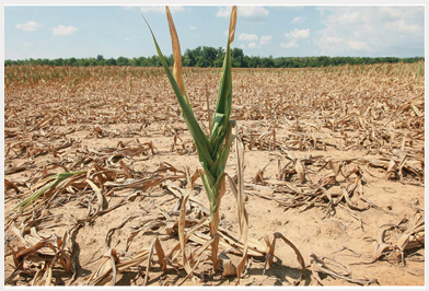
the causes of the above phenomenon.
ii) Explain the effects of drought to the people living in such area.
iii) Considering the physical conditions of Rwanda, suggest the districts
in which the above phenomenon is likely to happen and the strategiesto limit this problem.
Skills Lab
Provide specific examples and analyze how human activities affect climate change.
End unit assessment
1. Compare the factors that can cause the climate change in China
and Rwanda.
2. Explain the causes of climate change in developed and developing
countries.
3. The World needs to develop at high rate with its industrialization
processes which is among the most causes of greenhouse effects.
Suggest the mitigation measures for climate change in this regard.
4. The world is facing the problem of climate change and this is
substantially leading to the problem of desertification.
a. Indicate the most affected areas by that problem?
b. Suggest the sustainable strategies to address the problem ofdesertification.
UNIT 8: GLOBAL DRAINAGE SYSTEMS
Key Unit competence
The student-teachers should be able to investigate the economic importanceof the global drainage systems and the reasons for their conservation
Introductory activity
1. Do research using the internet and other geographical resources
to explain the following drainage terms: Drainage system, river
discharge, river velocity, catchment area, river divide and river basin
2. Explain the processes of river erosion, river transportation and river
deposition.
3. Explain the importance of drainage systems4. Discuss why there is need to conserve drainage systems
8.1. River system
Learning activity 8.1
1. Do research and explain the types of rivers and the river profiles.2. What do you understand by the concept of a river profile?
8.1.1. Definition of a river and the associated terms
A river is a large natural stream of fresh water flowing along a definite course,
usually into the sea, being fed by tributary streams. The water originates from a
known source and empties into a sea, lake or another river. The river flows alonga channel, whose water volumes increases as the river goes downstream.
The following terms are used in describing a river channel
Discharge: is the amount of water originating from precipitation which reaches
the channel by surface runoff, through flow and base flow. Discharge is,
therefore, the water not stored in the drainage basin by interception, as surface
storage, surface moisture storage or groundwater storage or lost through the
evapotranspiration.
River Velocity: Is the speed at which the water flows through the channel. It is
less at the sides and bed than at the center of a river. The velocity also depends
on the river’s gradient.
A river Basin: Is an area of land drained by a river and its tributaries. Its
boundary is marked by a ridge of high land beyond which any precipitation will
drain into adjacent basins. This boundary is called a watershed.
A river divide: This is the crest of the upland or mountain from which the
streams flow down the slopes on both sides to their journey.
River width: This is the distance across the surface of a river from one bank to
another bank.
River depth: Is the vertical distance from the river surface down to its bed.
River slope, also called river gradient is the angle between the horizon and
the river surface.
Catchment area is an area from which a river derives its water. This can be anupland or mountain.
8.1.2. Types of rivers
There are different types of rivers. The following are the main ones:
• Perennial River: This is a river with water flowing permanently in its
channel throughout the year.
• Intermittent River: This is a semi-permanent river which stops flowing
at some point in space and time. It stops to flow every year or at least
twice every five years.
• Ephemeral River: This is a seasonal river that flows only when thereis heavy rain or when snow has melted.
8.1.3. The river system: The work of a river
As a river moves from its source to its mouth, it performs the triple function
(three phases) of erosion, transportation and deposition. The following is the
work of a river:
A. River erosion
This involves the removal of different soils and rock particles of varying sizes
from the river’s bed and banks. Erosional work of rivers depends on the channel
gradient, the volume of water, the river’s velocity, water discharge and the
sediment load (amount of eroded material). The river erosion is at its peak when
the river passes through a steep gradient where the speed of flow is great. The
river erodes its bed and channel in the following ways:
• Hydraulic action: This is the process by which fast flowing water
enter into the cracks on the river bed and channel sides. The repeated
friction and pressure of water force cracks to widen and finally erode
weaker rocks.
• Solution or corrosion: This is the removal of rocks like salt, limestone
etc. that are soluble in water. Such rocks dissolve in water and are
carried in solution form.
• Abrasion or corrasion: This is the erosion of the river’s bed and
channel sides by the rolling action of materials or river load against rocks.
The heavier rocks transported in water rub and slid against the bed and
channel rocks eroding them as they are transported downstream.
• Attrition: This is the erosion of the river’s load by the load itself. As
rock fragments moving as load are transported downstream, boulders
collide with other material and they are fragmented and gradually
reduced in size, and their shape changes from angular to rounded.
B. River transportation and types of steam loads
Rivers transport refers to the carrying away of eroded material downstream.
As represented on figure below, rivers transport their load in the following ways:
• Solution: This is the downstream movements of soluble material like
salt, carbonates dissolved in water.
• Suspension: This is where the light particles of plants, soil and rocks
are carried away while floating or maintained within the turbulence flow of water.
• Saltation: This occurs when the load carried by the river is transported
in a series of short jumps or hops. It involves the transportation of
particles which are not too heavy but cannot remain suspended in
water. Materials such as pebbles, sand and gravel are temporarily lifted
up by the river currents and then dropped back along the bed in a
hopping motion. Such movements are known as hydraulic lift.
• Traction: This is where large and heavy materials are rolled, pushed
and dragged downstream by the force of moving water. Such materialsinclude rocks, pebbles and boulders.
Transport of solid load in a stream: Clay and silt particles are carried in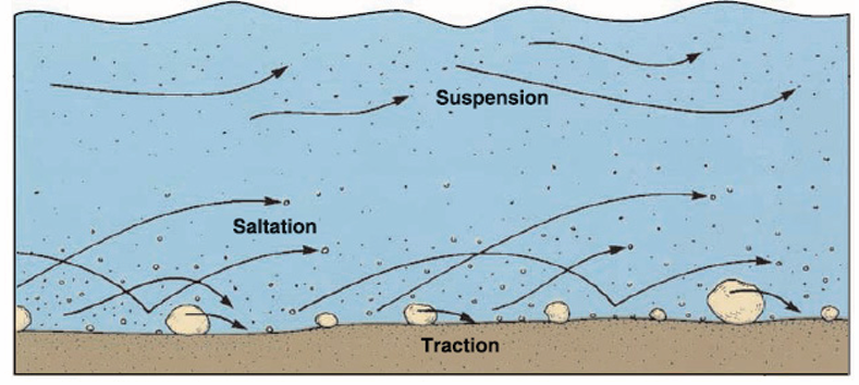
suspension. Sand typically travels by suspension and saltation. The largest
(heaviest) particles move by traction.
There are three main types of stream load.
1. Mineral and chemical elements of rock material held in solution constitute
the dissolved or solution load.
2. Suspended load consists of the small clastic particles being moved in
suspension.
3. Bed load is constituted of larger particles that move in traction along thestreambed.
C. River deposition
This refers to the situation where a river fails to transport its load. The river, then
drops its load due to the reduction in its energy. The heavy load is selectively
deposited first, while the fine and lighter particles are deposited last. The materialdeposited by a river is referred to as alluvium.
8.1.4. The river profile and its characteristics
A river profile is a section through the river channel from its source to its mouth
or from one bank to another. There are two types of river profile: cross profile
and long profile.
– Cross profile
This is also known as the transverse section of a river. It is the shape a river
assumes from one river bank to the other. It develops as a result of down
cutting and lateral cutting of the riverbed and banks by water currents. This
undercutting makes a section of a river valley, have different shapes and forms.For example, in the upper valley, vertical erosion produces a steep “V”-shaped
valley. However, this depends on the rate of erosion and weathering takingplace on the valley sides.
In the middle and lower stages, the river valley begins to become shallow andwide due to increased lateral erosion. The valley assumes a “U” shape.
– Longitudinal profile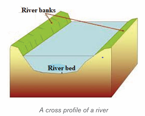
This is the longitudinal section of a river. It contains a variety of erosional and
depositional features. Based on its distinctive characteristics, the long profile of
a river is divided into three stages (upper/youthful, middle/mature and lower/oldstages) known also as normal cycle of erosion
The Course of a river presents three successive stages. They are represented
on figure bellow and described as follows:
• The youthful stage, referred to as upper stage of a river is found in
the mountains and hills where the river rises from its source. It has the
following characteristics:
– The topography at this stage is steep and the river is usually fast
flowing in the upper course.
– The main river gradually deepens its valleys.
– Often waterfalls and rapids are also found in this course;
– The main type of erosion is vertical. The valleys are narrow and deep.
– The features found in this stage include gorges, rapids and
waterfalls.
– There are lots of stones and boulders for the water to flow over.
The river starts as a stream in the upper course and flows throughV-Shaped valleys.
• Mature stage is known as valley stage. This middle course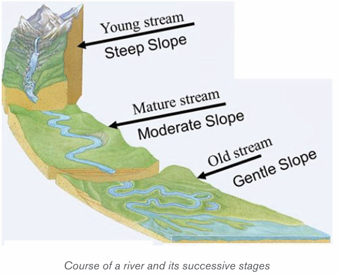
corresponds to the mature stream and presents the following
characteristics:
– This is the stage between the upper and lower courses of the river;
– The slope of the riverbed is reduced, and the speed of the water is
also reduced;
– The main type of erosion is lateral and the river begins to widen its
channel. There is also some deposition of sediments;
– More tributaries join the river, leading to a large volume of water;
– The river begins to meander or follow a winding course;
– The features found in this stage include cliffs, slip-off slopes and bluffs.
• Old stage, also known as the old stream, is the lower course
where the river becomes its widest and deepest. It has the following
characteristics:
– The slope of the river is very gentle; therefore, the river flows slowly.
– The valley is shallow, wide and flat.
– Seasonal floods occur.
– There is a lot of deposition of sediment on its bed.
– The features found in this stage include ox-bow lakes, deltas,floodplains etc.
Application activity 8.1
1. Explain the major work of a river.
2. Describe the characteristics of a river that you observe in your local
environment and how that river affects the environment around.
8.2. Formation of the major landforms associated with a river profile
Learning activity 8.2Observe the diagram below and answer the following questions.
1) Name the landforms labeled a, b, c, d and e;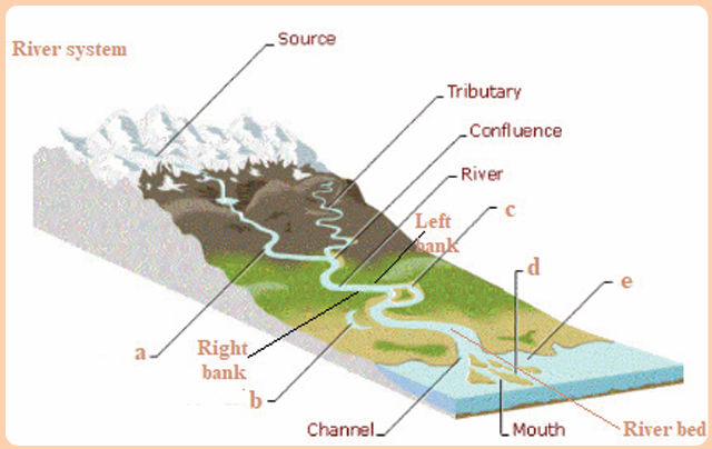
2) Apart from the features named above, what are other landformscreated by a river?
8.2.1. Formation of landforms in youthful stage
Youthful stage is the first stage of a river near its source. This stage is
characterized by a steep gradient, fast flowing water, vertical erosion etc. There
are several landforms that are created in this stage especially due to vertical
erosion and the nature of the gradient. The landforms like waterfalls and rapids,potholes and plunge pools are the main landforms:
i) Waterfalls and rapids
Waterfall refers to movements of water or simply sudden descents of water
due to abrupt breaks in the longitudinal course of the river. Waterfalls are mostly
caused by variations in the relative resistance of rocks and topographic reliefs.
A waterfall, therefore, is a vertical drop of a big volume of water from a great
height along the profile of a river.
Rapids are alternate breaks along the river’s profile. Rapids are smaller than
waterfalls. Generally, they are found upstream from the main falls, and are alsofound independently.
ii) Potholes and Plunge pools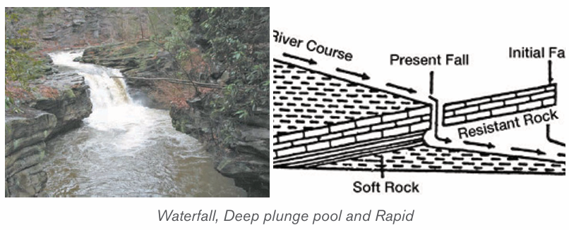
These are kettle-like and cylinder-shaped depressions in the rocky beds of the
river valley. They are circular depressions cut at the bed of the river by fast
flowing water. They are formed due to saltation and traction movement of large
pebbles and boulders on resistant rocks. Plunge pools are formed when pot
holes are further widened and deepened by circular and fast movements of water.
iii) Interlocking spurs
These are alternate bands of resistant rocks or hill sides formed when the river
attempts to avoid hard and resistant rocks on a steep gradient. The hard rocksare not eroded hence, the river meanders between interlocking headlands.
8.2.2. Formation of landforms in mature stage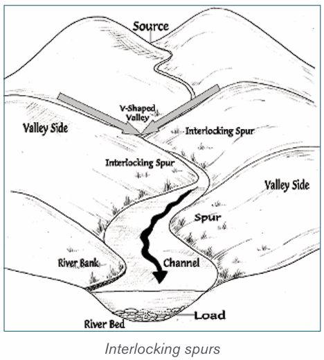
A mature stage of the river is the middle stage of a river’s course where the
gradient is lower and where the river begins to flow slowly as it widens itschannel.
The following are the major landforms:
i) River valleys: The valleys carved out by the rivers are significant erosional
landforms. The shape and dimension of fluvial originated valleys change
with the advancement of the stages of fluvial cycle of erosion.
ii) Gorges and Canyons: Are very deep and narrow valleys with steep
sides/slopes that are wall-like. They are formed when water falling over
the hard rock, undercuts the rock leaving it hanging. The hanging rocks
may cause water to retreat upstream leaving behind a narrow and deepsided valley
iii) Alluvial fans: These are fan-shaped deposits of coarse alluvium. They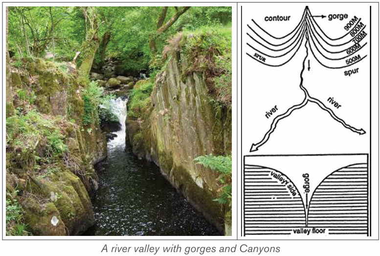
are formed when a fast flowing river loses its velocity when it enters the
gentle slope. The river immediately deposits its load composed of course
materials especially rocks, boulders and bigger pebbles. The depositsare laid in form of a fan, hence the name, “alluvial fan”.
iv) River Benches: These are step-like flat surfaces on either side of the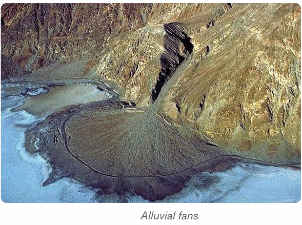
lowest valley. The benches or terraces formed due to differential erosion
of alternate bands of hard and soft rock beds are called structural
benches or terraces because of lithological control in the rate of erosionand consequent development of benches.
v) River terraces: The narrow flat surfaces on either side of the valley floor
are called river terraces which represent the level of former valley floorsand the remnants of former (older) flood plains.
8.2.3. Formation of landforms in old stage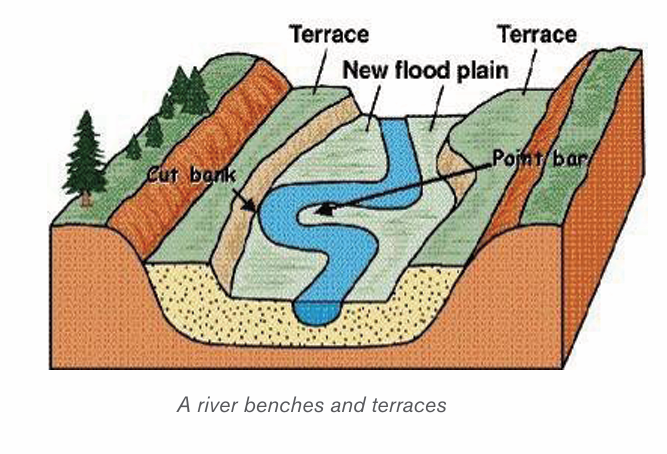
The lower or old stage of river is the last stage where a river nears its destination.
This stage is characterized by large deposits along the river’s bed and channel.
The large deposition is a result of increased lateral erosion, very slow movement
of water and very wide river channel. In this stage the river drops its load due to
the reduction in its energy. The material deposited by a river is called alluvium.
River deposition results into the formation of the following features:
i) River meanders
River meanders are the bends of the rivers. The bends of sinuous rivers have
been named meanders on the basis of Meander River of Asia Minor (Turkey)
because it flows through numerous bends. Each bend of the meander belt
has two types of slopes of valley sides. One side is characterized by concave
slope while the other side of the meander belt is characterized by convex slope.
The convex or slip off slope receives deposition mostly of sands and gravels
and alluvium at other times. Therefore, the bank of maximum deposition is also
called a slip-off slope. The concave slope is a bank of maximum erosion orundercutting. It is steeper than the slip-off slope.
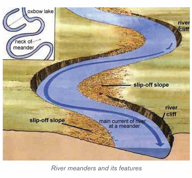
ii) An Ox-bow lake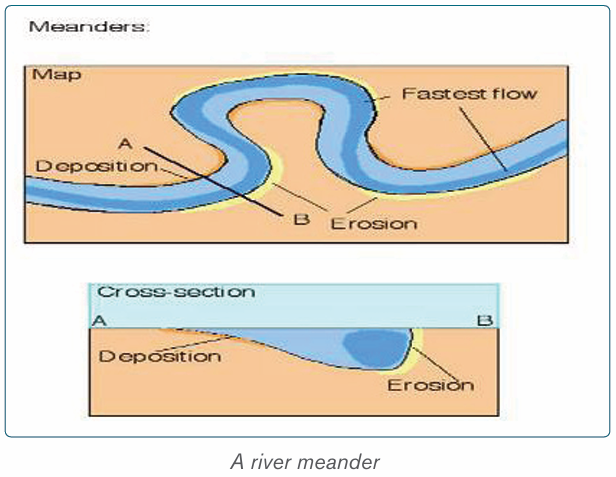
This is a horse-shoe lake formed due to stagnation of water in the abandoned
meander loop. Ox-bow lakes are formed when a river develops very pronounced
meanders in the flood plains. As erosion and deposition continues on the river’s
banks, the neck of the meander is cut off and the water flow straight by-passing
the old meander. The abandoned or cut off meander therefore becomes an oxbow lake.
iii) Flood plain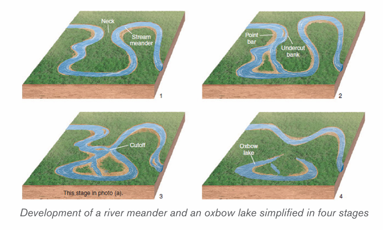
This is a very gentle low-lying plain of alluvial deposits on a floor of a river valley.
It is formed where a river flows in a meandering way. As a river swings back and
forth across the valley, it widens its valley floor. The valley becomes so broad
that the meanders swing freely without touching the valley sides. When the level
of water rises during the flood time, all the plain along the river valley becomesflooded. The river then deposits its alluvium in the plain.
iv) Levees
These are raised river banks made up of alluvial deposits. Levees are formed
when a river deposits its load along its banks during flooding. Slightly coarse
materials are deposited on the banks, while finer alluvium is transported further
onto the flood plains. With time, accumulation of coarse material raises the
banks of the river to form levees. During the dry seasons when the river retreats
into its channel, deposition are left both on the river’s bank and on its bed. Thisleads to the formation of raised river beds and banks.
v) Deferred tributaries
These are small tributary rivers that flow alongside the main river. They are
formed when raised levees stop tributaries from joining the main stream. As a
result, such tributaries, flow parallel to the main river until they encounter a break
in the river bank where they now can join the main stream. They are thus referred
to as deferred tributaries or Yazoo streams. The point at which they join the main
stream is referred to as a deferred confluence. The tributary flows to the mainchannel and finally break through levees and join the main channel.
vi) Braided channel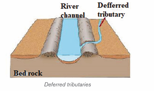
This is a wide and shallow channel where a river breaks into a series of
interconnecting distributaries separated by sandbanks and islands of alluvium. It
is formed in the middle or old stage of a river where the valley is wide and gently
sloping. The river carrying a large load flows at a low velocity, fails to transport
its load and finally deposits its load on the bed. Gradually, the river bed is raisedand the deposits divide the flow of water into small tributaries and distributaries.
vii) Delta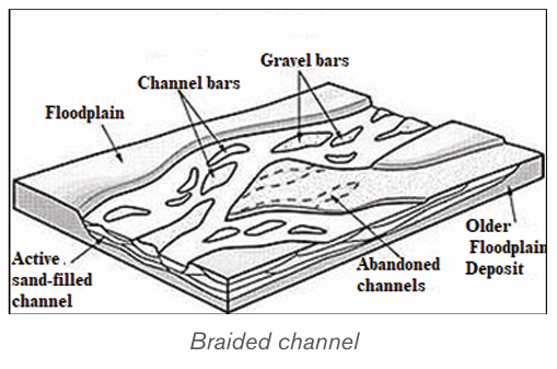
A delta is a low-lying swampy plain of alluvium at the mouth of a river. A delta
forms when a river fails to carry its entire load into the sea or mouth but deposits
these into its mouth. The deposits divide the river’s mouth into tributaries and
sub tributaries. The deposits gradually become colonized by various types of
plants and form a triangular shaped mouth of a river. This is called delta. The
river splits up into several separate channels in much the same way as river
braids. Deltas are classified into three categories depending on the shape and
growth where there are growing deltas and blocked deltas. They include the
following:
• Estuarine deltas,
• Arcuate deltas,
• Bird’s foot deltas.
– Estuarine delta: This is a submerged mouth of a river. It is a delta formed
from materials deposited in the submerged mouth of a river. This takes the
shape of the estuary. Examples are the Zambezi Estuary in Mozambique,
and Volta Delta in Ghana.
– Arcuate delta: this is a triangular and convex shaped delta. It is formed
by a river with many distributaries transporting materials. It occurs where
off-shore currents are strong enough to round the seaward edge of the
delta. Examples are Sondu Delta in Kenya, Nile Delta in Egypt and Amazon
Delta in Brazil.
– Bird’s foot delta: This is a delta that looks like the claws of a bird’s foot.
It is also known as digitate delta. It is formed when a river transporting
large load of mainly fine material enters into water that has low energy wave.
The distributaries extend from the shore into the open water. Examples areOmo River Delta on Lake Turkana and Mississippi Delta in the USA.
Application activity 8.2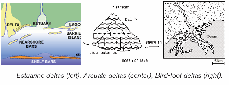
1. Visit the nearest rivers and do the following:
i) Identify the landforms formed along a river.
ii) Explain the importance of the above landforms to the local people.
2. Describe the relationship between landforms in the lower stage of ariver and human activities
8.3. River capture, river rejuvenation, superimposed and
antecedent drainage and impact of rivers
Learning activity 8.3
1. Make a research and establish the effects of the river capture and
river rejuvenation.
2. Identify how superimposed and antecedent drainage are formed.3. Discuss the importance of rivers.
8.3.1. River capture
A) Definition of river capture
River capture refers to the diversion of headwaters of a weaker river system into
a system of the stronger neighboring river. It is also referred to as river piracy.
The point of capture is known as “elbow of capture”. This point is usually found
near the dry valley or misfit stream. A misfit stream is the river whose water
has been beheaded or diverted into another stream. It contains very little or no
water at all and is not therefore fit to be in that river. This is why it is called misfit
stream. Beyond the misfit stream is a valley that no longer contains water. It isonly covered by old alluvial deposit. This is called a dry valley.
B) Features of river capture
There are four major features of river capture: elbow of capture, cols or windgaps, misfit or under fit streams and dry valleys.
C) Causes of river capture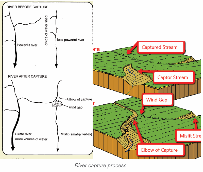
A river capture can be caused by headward erosion, lateral erosion, or
coalescence of meanders. The following are the causes of river capture:
• The presence of a river with a larger volume of water compared to its
neighbour (the weaker river). The stronger river erodes its valley faster
by vertical erosion compared to its neighbour.
• The presence of soft and easily eroded rocks in the valley of a stronger river
• Earth movements like faulting, folding, warping and volcanicity on the
valley of a stronger river can also cause river capture
• Change in base level as a result of river rejuvenation. A fall or rise in a
river’s base level can cause river capture
For river capture to take place, the following conditions are necessary:
• There must be a powerful river or pirate stream and a misfit stream
flowing adjacent or parallel to each other.
• The pirate river must be flowing over a much steeper valley than the
misfit or beheaded stream
• The pirate river must be having more active head ward erosion compared
to its neighbouring river
• The pirate river must be flowing over easily eroded rocks compared to
those of its neighbour
D) Effects of river capture
The following are the effects of river capture (after the occurrence of river
capture):
• The volume of water in the pirate stream increases;
• The capturing/beheading river becomes bigger and more stronger than
it was before capture;
• The beheaded stream having lost its waters contains very little water
and almost dries off (a misfit river);
• The pirate river develops an elbow of capture. This denotes a sharp
change in the direction of a river course (at the point of capture);
• The valley of the beheaded stream below the point of capture becomes
dry and hence the name, “wind gap”;
• Incision of the pirate river near point of capture. This valley becomes
wider due to increased vertical erosion (head ward erosion).
8.3.2. River rejuvenation
A) Definition of river rejuvenation
River rejuvenation is the renewed erosive activity of a river. It is an acceleration
of erosive power of the fluvial process of rivers. Rejuvenation length is the period
of the cycle of erosion. For example, if the cycle of erosion is passing through
senile stage (old stage) characterized by gentle channel gradient, sluggish river
flow and broad and shallow alluvial valleys, after rejuvenation (caused either
due to substantial fall in sea level or due to uplift of landmass) the cycle is
interrupted and is driven back to juvenile (youth) stage characterized by steep
channel gradient and accelerated valley incision.
There are three types of rejuvenation as follows:
i) Dynamic rejuvenation: It is mainly caused by uplifting in the landmass,
tilting of land area and lowering of the outlet.
ii) Eustatic rejuvenation: This occurs because of changes in sea level
due to diastrophic events (subsidence of sea floor or rise of coastal land)
and glaciations causing fall in sea level.
iii) Static rejuvenation: Its main causes are decrease in the river load,
increase in the volume of water and consequent stream discharge due
to increased rainfall, increase in water volume of the main river due to
river capture.
B) Causes of river rejuvenation
River rejuvenation is caused by the following:
• A fall in base level or fall in the level of the sea.
• Earth movements involving uplift, down faulting
• River capture which may cause an increase in the volume of water (river discharge)• Change in rock resistance
C) Effects of river rejuvenation on the landscape
River rejuvenation produces several features as follows:
• Knick point: This is a break of slope in the long profile of a river valley.
It indicates the point where rejuvenation started. Knick points are
associated with rapids and water falls.
• Paired terraces: These are steps or bench-like river valleys on both
sides of a rejuvenated valley. They are marked by old alluvial deposits
laid down before river capture occurred. It is therefore a part of the
former flood plain valley that is above the present river level.
• Incised meanders: An incised meander is a curved bend of a river
that has been incised or cut into the land surface so that a river now
winds between steep valley walls. Incised meanders develop from an
already meandering river.
• Ingrown meanders: These are incised meanders with asymmetrical
steep valley sides. They develop on resistant rocks and where the base
level falls gradually and the meander shifts gradually and laterally
• Valley within a valley: This is also referred to as a rejuvenation gorge.
These are steps at the opposite sides of a rejuvenated valley. They form
where rejuvenation was very rapid with a large fall in base level. The
river flows in a deep channel within paired terraces that were once theremains of the flood plain.
8.3.3. Superimposed and antecedent drainage
A) An antecedent drainage
This is a drainage made of streams that maintain their original course and
pattern despite the changes in underlying rock topography. Antecedence is
when the drainage pattern developed before such structural movements as the
uplift or folding of the land, and where vertical erosion by the river was able to
keep pace with the later uplift. A stream with a dendritic drainage pattern for
instance, can be subject to slow tectonic uplift. However, as the uplift occurs,
the stream erodes through the rising ridge to form a steep-walled gorge. The
stream thus keeps its dendritic pattern even though it flows over a landscapethat will normally produce a trellised drainage pattern.
B) A superimposed drainage
This kind of drainage pattern seems to have no relationship to the present-day
surface rocks. Superimposed pattern is a drainage that formed over horizontal
beds that overly folded and faulted rock with varying resistance. The stream
erodes through the underlying horizontal beds, and retains its course and
pattern despite changes in the underlying rock. The stream erodes a gorge inthe resistant bed and continues its flow as before.
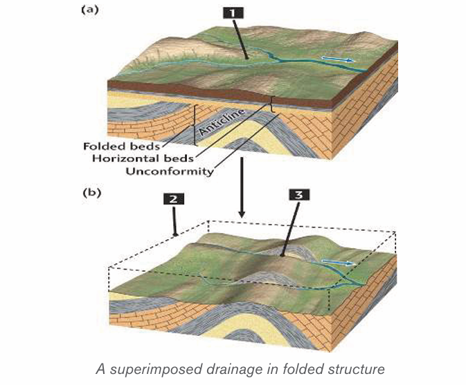
8.3.4. Impact of rivers
Rivers play an important role both to human beings and the surrounding
environments. Rivers can also negatively affect people and the surroundingenvironments.
A) Positive impacts of rivers
The rivers and riverine landforms present the following advantages for humans:
– Rivers provide water for various uses such as domestic, industrial uses,
drinking by animals;
– Navigable rivers provide natural route-ways used for transportation;
– Rivers provide water for irrigation especially in areas of low rainfall. This
promotes agriculture, hence increasing food production;
– Waterfalls provide natural sites for the production of hydroelectric
power. Examples are: waterfall between lakes Burera and Ruhondo,
River Rusizi in Rwanda, River Tana in Kenya, River Volta in Ghana, water
falls along River Nile, etc;
– River Ria, estuaries and deltas are deep and sheltered, hence they
promote the development of ports like Alexandria on the Nile delta;
– Building materials such as sand, gravel and pebbles are obtained from
river beds and valleys;
– Some rivers have spectacular features such as waterfalls, gorges and
canyons which attract the tourists. For example, Rusumo falls on river
Akagera in Rwanda;
– Alluvial deposits in some river valleys are a source of valuable minerals
such as alluvial gold for example in Miyove valleys in Northern Province
of Rwanda;
– Building materials such as sand, gravel and pebbles are obtained from
riverbeds and valleys;
– Flood plains and deltas contain fertile alluvial soils which have been
exploited for agriculture. Example is the Nyabarongo river valley, Nile
valley in Egypt etc;
– The livestock activities are mostly developed near water bodies wheredrinking and green vegetation water is available throughout the year.
B) Negative effects
The following are some of disadvantages of rivers and riverine landforms that
influence negatively humans:
– Some large rivers form barriers to communication between communities
of the same culture;
– During flooding some rivers cause destruction of property and loss of
human life;
– Some river water may act as a medium for the spread of water borne
diseases, for example, Malaria, Bilharzia;
– Some rivers host dangerous animals such as crocodiles and
hippopotamuses. These at times attack human beings and destroy crops.
Application activity 8.3
1. Using your knowledge and skills acquired in this unit, explain the
factors that favour river capture.
2. Examine the difference between river capture and river rejuvenation.
3. Analyze the impact of rivers to the development of the country.
8.4. Lakes, Seas and Oceans
Learning activity 8.4
1. Identify any 5 lakes found in Rwanda.
2. Use internet and other geographical resources to research on typesof lakes and their mode of formation.
8.4.1. Types of Lakes
A lake is a large mass of water that occupies a basin or depression on the
surface of the earth. Lakes receive water from streams, overland flow, and ground
water, and so they form part of drainage systems. Lakes may be permanent or
seasonal. This depends on the volume of water that gets in, and the amount of
water that is lost. The loss of water is through evaporation and river outlets.
Lakes are categorized according to their mode of formation. They are grouped
in various ways as follows:
– Through earth movements (tectonic lakes)
– Volcanic action (lava dammed and crater lakes)
–Erosion (erosional lakes)
– Deposition (depositional lakes)– Human activities (man-made lakes)
8.4.2. Mode of formation of Lakes
The lakes are differentiated on the basis of their mode of formation. The followingare the major modes of lakes’ formation.
A) Lakes formed by earth movements
Lakes caused by crustal warping: These are lakes that occupy a basin
like depression. They were formed when water occupied down warped basins
immediately after crustal warping. These lakes are also called subsidence
Lakes. Examples are Lake Chad and Lake Victoria in Africa. In Rwanda, Lakeslike Muhazi, Mugesera, Cyohoha were also formed as a result of subsidence.
Rift Valley Lakes: These are Lakes that occupy depressions within rift valleys.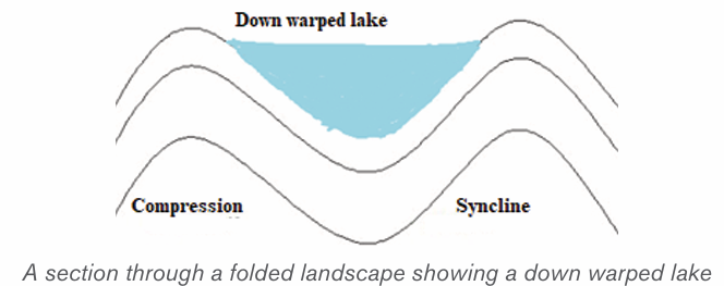
They are usually deep, elongated, and have steep sides. They are located on
the floor of a rift valley. Examples are Lakes Kivu in Rwanda, Turkana in Kenya,Tanganyika and Malawi in Tanzania.
B) Lakes produced by glacial erosion and glacial deposition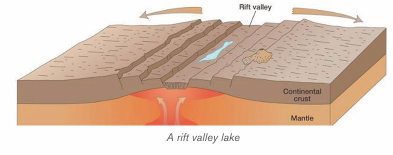
Cirque lake, also call a Tarn Lake is a Lake that forms in a glaciated highland.
Such lake occupies an armchair-like depression, called a cirque. During thawing
(melting of snow), water collects in circular depressions that were left behind
where large avalanches or boulders were uprooted by melt glaciers.
A cirque lake sometimes feeds a mountain river. Tarns occur on the sides ofMount Kenya like Teleki Tarn and on Mt Rwenzori for example Stanley Lake.
Trough Lake: This occupies an elongated hollow excavated by ice on the floor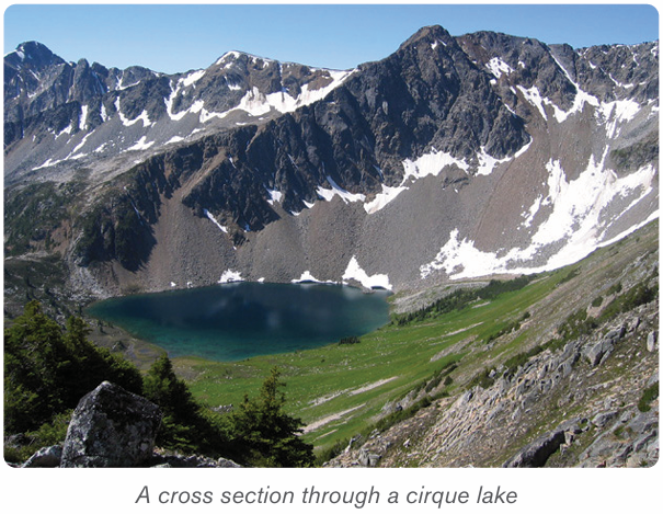
of U-shaped valley. It is sometimes called a ribbon lake. Lake Michaelson, in theGorges Valley, near to Mount Kenya, is a trough lake.
• Kettle Lakes: These are small lakes that are formed in depressions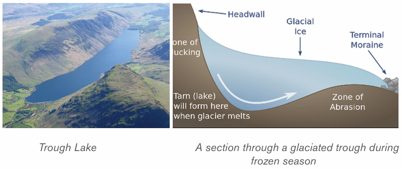
in glaciated lowlands. They are formed when melt water occupy
depressions called kettle holes.
• Moraine dammed lakes: These are lakes that form in glaciated
lowlands when a moraine dams the flow of melt waters in glaciatedlowlands.
C) Lakes produced by wind erosion
These are lakes that form in desert depressions left behind where large masses
of sand dunes and pebbles have been removed. Wind deflation sometimes
produces extensive depressions which reach down to the water-table in arid
deserts. The lakes of these depressions are not always true lakes-they may
be nothing more than muddy swamps. The Quattara depression, in Egypt, is a
good example.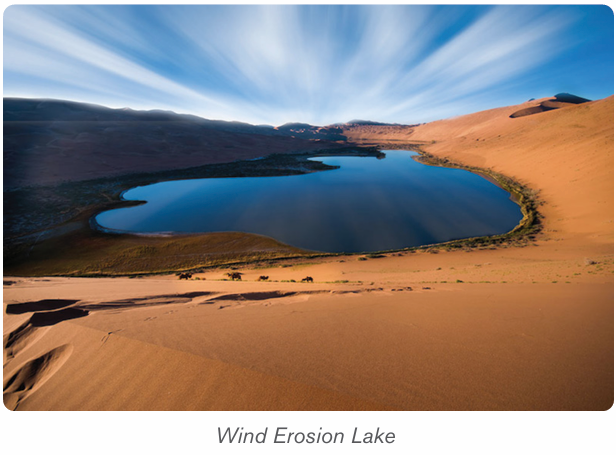
More permanent desert lakes develop when an aquifer becomes exposed.
These lakes are called oases. Some desert lakes dry up because of excessive
evaporation and all that remains is a lake bed of salt. This is called a playa or a
Salt Lake.
D) Lakes produced by river deposition
Ox-bow Lake: It is formed when a meander loop of a river on a flood plain iscut off from the main river. The river Galma, in Nigeria, has several ox-bow lakes.
Delta Lake: This Lake is formed by the deposition of alluvium by rivers turning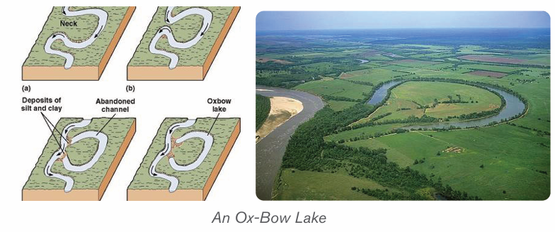
either a part of the sea into a lagoon, or part of a distributary into a lake. TheEtang de Vaccares is a delta lake. Delta lakes occur in the Nile Delta, in Egypt.

Flood plain Lake: A levée sometimes prevent water from returning to the river,
thus causing a lake to form. There are several lakes of this type on the RiverCongo.
Boulder Clay Lake: Some boulder clay deposits contain depressions which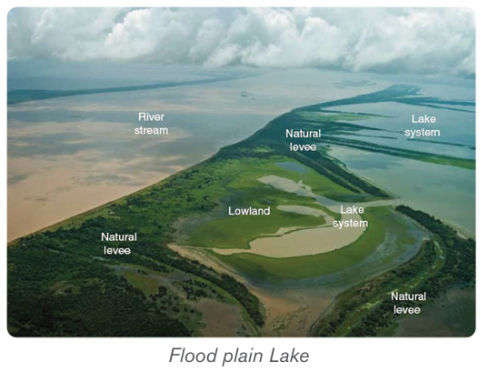
become the sites for lakes. There are lakes of this type in Northern Ireland.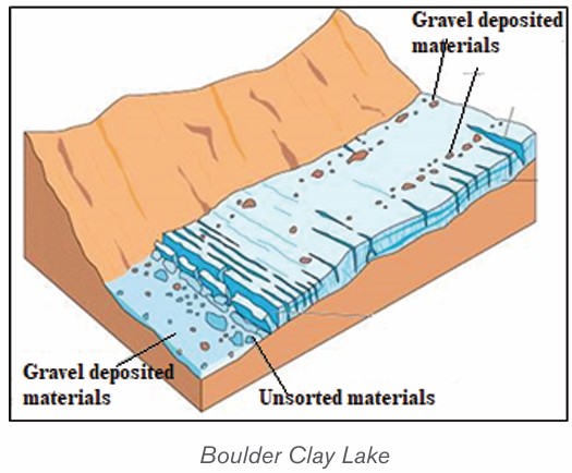
A. Lakes produced by marine deposition
Lagoon: This is a lake formed by a sand bar or sand spit extending along a
coast and cutting off a coastal indentation hence forming a lagoon. Sometimesa barrier beach extends across the mouth of a river, producing a lagoon.
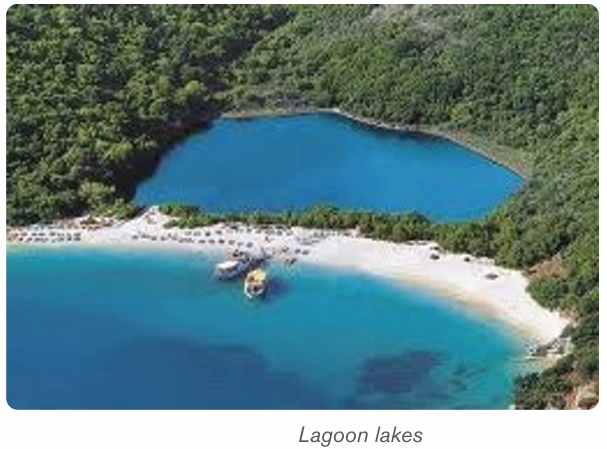
B. Lakes produced by volcanicity:
1. Crater lakes or caldera lakes are formed in volcanic craters and calderas,
which fill up with precipitation more rapidly than they empty via evaporation,
groundwater discharge or combination of both. Crater (small volcanic
depression) and Caldera (large volcanic basin) There are several caldera
lakes in Africa: Lake Shala, in Ethiopia, Lake Ngorongoro in Tanzania, Lake
Toba, in Sumatra (Indonesia) is also a caldera lake. In Rwanda, the CraterLakes are also found on Mountains Bushokoro, Muhabura and others.
2. Lava-dammed lake: A flow of lava may sometimes block the flow of a river
valley which causes a lake to form. The Sea of Galilee, in the Jordan valley,
was formed by lava damming the flow of river Matiandrano. The lava dammed
lakes in Rwanda are Lakes Burera and Ruhondo in Burera district of NorthernProvince.
C. Other types of lakes
– Solution Lake: This sometimes develops in a limestone area when
rainwater has dissolved the rocks to form a cave, and when the floor of
this cave is near to the base of the limestone. Lake Scutari, in Yugoslavia,
is a solution.
– Temporary Barrier Lake: Such a lake forms when an avalanche, or
scree fall, or landslide blocks a river valley. A lake of this type is only
temporary.
– Man-made lake: This is often called a reservoir. It is deliberately
formed by building a dam across a narrow, steep-sided section of
a river valley, usually a gorge, or constructing a wider depression or
water dam to trap rain water in a valley for the purpose of storing water
for irrigation, wet rice cultivation or for developing hydroelectricity or
both. Such lakes in Rwanda are Cyabayaga in Nyagatare District and
Rugeramigozi in Muhanga District.
– Lakes produced due to mass movement: Movement of debris
down slope due to the influence of gravity may block a river valley. They
may be landslides, mudflows, avalanches or rock slides.
– Lakes produced by alluvial deposits: These are lakes formed
because of back ponding by rivers. Such lakes form in depressions
within river valleys. Examples of such lakes are; Rweru, Ihema, Hago
Rwanyakizinga etc. along the valley of river Akagera.
8.4.3. Impact of lakes
The usefulness of lakes to human society are briefly described below.
• Source of fish: Lakes are habitats for different varieties of fish. This
has favoured the development of fishing and related industries.
• Source of minerals and natural gases: lakes such as Magadi in
Kenya, Natron in Tanzania and Katwe in Uganda are source of salt, Lake
Kivu in Rwanda contains natural gas.
• Tourism: Lakes provide beautiful sceneries and other activities which
attract tourists. This earns a country foreign exchange.
• Cheap transport: Lakes form cheap natural waterways for goods
and passengers.
•Source of power: Some lakes have been harnessed for the generation
of hydroelectric power. For example, Lakes Burera and Ruhondo
generate power on Ntaruka hydroelectric power plant.
• Source of useful water: Lakes are sources of water for domestic and
industrial uses.
• Source of drinking water for animals like cattle, sheep, goats, etc.
• Source of building materials: Some lakes are source of building
and construction materials such as sand, pebbles, small rocks, water
used in construction, etc.
• Regulating river flow: Some lakes help in controlling floods by
regulating the flow of rivers.
• Modification of climate: Lakes are important factors controlling the
climate of the surrounding areas because they provide the moisture.
The lakes also modify the climate of the adjacent areas.
• Source of rivers: Some lakes are sources of rivers. They act as
reservoirs and stores of water to rivers. For example, Lake Kivu is a
source of river Rusizi, Lake Muhazi is source of Nyabugogo River, etc.
8.4.4. Distribution of seas and Oceans
A) Distribution of Seas
A sea is a very large mass of saline water that occupies a very huge depression.
Seas occupy large basins on the continental margins. Lakes are smaller than
seas but seas are also smaller than oceans. Seas are of two types namely:
• Inland seas. These are shallow seas over part of a continent. They are
connected to oceans by straits
• Marginal Sea. This is a sea partially enclosed by islands, archipelagos,
or peninsulas, adjacent to or widely open to the open ocean at the
surface, and/or bounded by submarine ridges on the sea floor.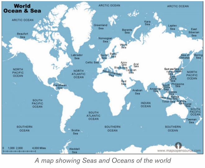
B) Distribution of oceans
An ocean is a large mass of saline water. Oceans occupy basins between
continents. There are five oceans in the world. These are as follows:
• Southern (Antarctic) Ocean: with an area of 20 million kilometers square
• Arctic Ocean: with an area of 14 million kilometers square
• Indian Ocean: with an area of 68.5 million kilometers square
• Atlantic Ocean: with an area of 76 million kilometers square• Pacific Ocean: with an area of 155 million kilometers square
Application activity 8.4
1. Draw a sketch map of Rwanda and on it indicate the types of Lakes.2. Explain their mode of formation.
Skills Lab
Water pollution is a result of human activities. Give advice on how to
prevent it.
End unit assessment
1. Some ocean currents originate from warm regions and others from
cold regions. Describe the relationship between ocean currents and
the atmospheric circulation.
2. Conduct your own research to describe the major ocean management
projects in the world.
3. Discuss the economic advantages of drainage in Rwanda, and in the world.
4. Explain the strategies to mitigate natural hazards associated withdrainage system.
REFERENCES
Afedrary, L. (2015). Soil erosion. Retrieved from https://www.monitor,co.ug/
Farming.
Bishop, V. a. (2001). Water Resources: Processes and Management. London:
Collins Publishers.
Buckle C. (1978). Landforms in Africa. London: Longman.
Bunnet R.B. (1973). General Geography in diagrams. Pearson Education
South Asie Pte Ltd.
Bunnet R.B. (1984). Physical geography in diagrams for Africa. Longman.
Bunnet R.B. (2010). Physical geography in diagrams for Africa. Kigali: Longman.
Bunnet, R. B. (2008). General Geography in Diagrams Longman. London:
PEARSON Longman.
Byamugisha, B. (2010). Physical Geography: A Systematic Study in Geomor
phology and Climatology for advanced level students. Kampala: Kabs Publishers Ltd.
Byamugisha, B. (2010). Sysematic Study in Geomorphology and Climatology
for Advanced level Students. Kampala.
Byizigiro, V., & Biryabarema. (2009). Soil erosion. Kigali: Rwanda Natural Science.
Christopherson, R. W. (2012). An Introduction to Phyisical Geography: Geo
systems. New Jersey: Pearson Prentice Hall.
Collins Buckle. (2007). Landforms and landscapes in Africa: AN introduction
to Geomorphology. Ednburgh: Pearson Education Limited.
Gabler, R. P. (2009). Physical Geography. Belmont: Brooks/Cole, Cengage
Learning.
Glencoe. (1999). Earth Science: Teacher Wraparound Edition. Westerville:
McGraw-Hill.
Henrie M.K. (2009). Principles of Physical Geography. Kampala: Compsolutions.
John Whitton. (1984). Dictionary of Physical geography. New York: Nwe York .
Kallie, S. (2017 , July 16). The Yellow River. Retrieved May 6, 2018, from
www.thoughtco: https://www.thoughtco.com/yellow-river-in-chinas-histo
ry-195222
Kichodo, H. M. (2009). Principles of Physical Geography: Advanced Level
Geography. Kampala: HMK.
Mcmaster, D. N. (2000). Mapreading for East Africa Longman. Edinburgh:
Longman.
Minns, W.J. (1984). A geography of Africa. Macmillan.
MonkHouse, F.J. (2008). Principles of physical Geography. London: Hodder
Education.
NAPA-RWANDA. (2006). National adaption programs of action to climate
change. Kigali: Ministry of lands, environment, forestry, water and mines.
Ndehedehe, C. E. (2017). Analysis of hydrological variability over the Volta
river basin using in-situ data and satellite observations. Journal of Hydrology:
Regional Studies, 88-110.
Nzabona A.C.N (1998). Physical Geography for Advanced level: Questions
and essay guides. Published in Kampala (U).
Safari Sibo et al. (2013). MK SENIOR 5 SECONDARY GEOGRAPHY STU
DENTS BOOKS. Kampala: MK.
S-Cool.CO.UK. (n.d.). Elluviation and illuviation processes of weathering. Re
trieved from https://www.google.rw/search.
SENTAMU, S. A. (2011). Statistics and geography of the world. Kampala.
Strahler, A. (2011). Introducing Physical Geography, 5th Ed. Boston: John
Willey and & Sons Inc.
Strahler, A. a. (2008). Visualizing Physical Geography. Hoboken: John Wiley &
Sons.
UK ESSAYS. (March, 2015). The importance of the Nile River. Environmental
science essay.
UNICEF. (2008). Rwanda earthquakes: Unicef responds to immediate needs
of children and women affected by earthquakes. Kigali: Unicef.
Water Technology. (1983, January 1). Retrieved May 6, 2018, from www.
water-technology.net: https://www.water-technology.net/projects/aswan-high
dam-nile-sudan-egypt/
Water-resources. (2010, Jan 1). https://www.nextgurukul.in/wiki/. Retrieved
April 23, 2018, from Waugh, D. (2009). Geography: An Integrated Approach.
London: Nelson Thornes.
Whitton, J. B. (1984). Dictionary of physical geography. New York: PEGUIN
BOOKS.
Whittow J. (1984). Dictionary of physical geography. Penguin books.
Wu, A. ( 2015, September 21). The Geography of the Yellow River. Retrieved
May 6, 2018, from chinahighlights: https://www.chinahighlights.com/yellowriv
er/geography.htm
Active continental margins: Continental margins that coincide with
tectonically active plate. Asthenosphere: The plastic like, soft layer below the
lithosphere in earth’s mantle, beneath the rigid lithosphere.
Adaptation measures for climate change: Measures and strategies taken
to adapt to climate change and its variability.
Aerosols: Suspended Particulate Matter (SPM) in the atmosphere including
solid particles of varying sizes and liquid droplets are collectively called aerosols
which include: ploughed soil cover, deserts, rocks, salt particles from seas and
oceans; meteoric particles, organic matter: bacteria, seeds, spores and pollen.
Andesite: Extrusive igneous rock of diorite composition, dominated by
plagioclase feldspar; the extrusive equivalent of diorite.
Antecedent drainage: A part of a river slope and the surrounding area uplifts
but the river maintains its original slope.
Basalt: Extrusive igneous rock of gabbro composition; occurs as lava.
Bleach coral reefs: These are white coral reefs after expelling the algae
(zooxanthellae)
Clay minerals: class of minerals produced by alteration of silicate minerals,
having plastic properties when moist.
Clay: sediment particles smaller than 0.004 mm in diameter.
Climate change mitigation: Involves reductions in human (anthropogenic)
emissions of greenhouse gases.
Climate variability: It is variations of atmospheric conditions at a specific
location or globally in short term.
Coal: Rock consisting of hydrocarbon compounds, formed of compacted,
lithified, and altered accumulations of plant remains (peat).
Collision: Process where two continental crust collide and, as neither can sink,
are forced up into fold mountains.
Compression (tectonic): Squeezing together, as horizontal compression of
crustal layers by tectonic processes.
Conglomerate: A sedimentary rock composed of pebbles in a matrix of finer
rock particles.
Continental crust: Crust of the continents, of felsic composition in the upper
part; thicker and less dense than oceanic crust.
Continental drift: Hypothesis proposed by Alfred Wegener, which states that
continents have moved horizontally around the globe, over time, to reach their
current location.
Continental lithosphere: Lithosphere bearing continental crust of felsic
igneous rock.
Continental margins tectonic: Marginal belt of continental crust and
lithosphere that is in contact with oceanic crust and lithosphere, with or without
an active plate boundary being present at the contact.
Continental margins: A zone which combines both the continental shelf and
the continental slope and is distinct from the deep-sea floor.
Control Gate: A facility used to control over the water travelling in penstock.
Convection current: The driving forces of plate tectonics in which hot, plastic
like material from the mantle rises to the lithosphere, moves horizontally, cools,
and sinks back to the mantle.
Convergent boundary: In plate tectonics, the boundary between two plates
that are converging, or moving toward each other.
Coral reef: Skeletons of very small sea creatures.
Coral: A marine polyp capable of secreting calcium carbonate to build an
external skeleton.
Coriolis force: Deflecting motion caused by the rotation of the earth which
makes a body or current moving across its surface to be deflected to the right
in the north hemisphere, and to the left in the south hemisphere.
Crane: A type of machine, generally equipped with a hoist rope, wire ropes or
chains, and sheaves that is used both to lift and lower the gates which regulate
intake gates or water flow from reservoir through the tunnel of a dam.
Crust: Outermost solid layer of the earth, composed largely of silicate materials
Dam: a barrier constructed across a river to hold back water and raise its level,
forming a reservoir used to generate electricity or for domestic, irrigation or
industrial water supply. Some dams are built also to preventing the flow of water
or loose solid materials (such as soil or snow).
Deposition: The laying down of material that has accumulated after having
been eroded and transported.
Desertification: Land degradation in which a relatively dry land region
becomes increasingly arid, typically losing its water bodies as well as vegetation
and wildlife.
Development: The process in which some economic sectors or activities
(e.g. agriculture, industry, technology, etc.) grow or change and become more
advanced
Diorite: Intrusive igneous rock consisting dominantly of plagioclase feldspar
and pyroxene; a felsic igneous rock.
Divergent boundary: In plate tectonics, the boundary between two plates that
are diverging, or moving away from each other.
Dolomite: Carbonate mineral or sedimentary rock having the composition
calcium magnesium carbonate.
Drainage pattern: A plan made by a river and its tributaries along the landform
Dredging: Clear the bed of a harbour, river, or other area of water by scooping
out mud, weeds, and rubbish with a dredge”the dredging and deepening of the
canal”.
Dry farming: This is also called Dry land Farming. It is the cultivation of crops
without irrigation in regions of limited moisture, typically less than 20 inches (50
centimetres) of precipitation annually.
Earthquake: A trembling or shaking of the ground produced by the passage
of seismic waves.
Ecosystem: Total living things in an area including ways they interact each
other in the environment
Effluents: Liquid waste or sewage discharged into a river or the sea from
industries.
Eustasy: any uniformly global change of sea level that may reflect a change in
the quantity of water in the ocean, or a change in the shape and capacity of the
ocean basins
Extinction: the state or process of being or becoming extinct /disappearance,
vanishing.
Extrusive igneous rock: Rock produced by the solidification of lava or ejected
fragments of igneous rock (tephra).
Feldspar: Group of silicate minerals consisting of silicate of aluminum and
one or more of the metals potassium sodium, or calcium (See also plagioclase
feldspar, potash feldspar)
Felsic igneous rock: Igneous rock dominantly composed of felsic minerals.
Felsic minerals (felsic mineral group): Quartz and feldspars treated as a
mineral group of light color and relatively low density. (See also mafic minerals.)
Flood control: Methods are used to reduce or prevent the detrimental effects
of flood waters.
Gem: Also called Game stone is a valuable mineral highly prized because it is
rare and beautiful.
Gentle slopes: These are areas located in rolling countryside where slope is
between 5 and 15% and the pattern of rainfall distribution regularly results in
erosion events. They are very common in Mediterranean countries
Glacier: It is a large mass of ice in motion.
Gondwanaland: A supercontinent of the Permian period including much of the
regions that are now South America, Africa, Antarctica, Australia, New Zealand,
Madagascar, and peninsular India.
Granite: Intrusive igneous rock consisting largely of quartz, potash feldspar
and plagioclase feldspar with minor amounts of biotite and hornblende; a felsic
igneous rock
Gravity: The force by which objects are attracted to one another because of
their mass on the earth surface.
Greenhouse effect: Is process in which atmosphere of earth trap some of
heat coming from sun, making Earth warm than usual.
Holomorphic soils: These are intrazonal soils which have developed in areas
where salts have accumulated at or near the surface.
Hurricane: A type of tropical cyclone with sustained winds that exceed 74 mph
and accompanied by rain, thunder and lightning
Hydromorphic soils: These are intrazonal soils developed in presence of
excess water.
Ice cap: An area of permanent ice.
Intrusive igneous rock: Igneous rock body produced by solidification of
magma beneath the surface, surrounded by preexisting rock.
Laurasia: A supercontinent of the Permian period, including much of the region
that is now North America and western Eurasia.
Lava: Magma emerging on the Earth’s solid surface, exposed to air or water.
Levee: Also called embankment or flood bank or stop bank is an elongated
naturally occurring ridge. It is usually earthen and often parallel to the course of
a river in its floodplain or along low-lying coastlines.
Lithosphere: The rigid, outermost rock layer of the earth, about 100 km thick,
composed of the crust and part of the mantle, lying above the asthenosphere.
Mafic igneous rock: Igneous rock dominantly composed of mafic minerals.
Mafic minerals (mafic mineral group): Minerals, largely silicate minerals, rich in
magnesium and iron, dark in color, and of relatively greater density.
Magnetometer: A sensitive instrument that records magnetic data and is used
to study earth’s magnetic field.
Marble: Variety of metamorphic rock derived from limestone or dolomite by
recrystallization under pressure.
Metamorphic rock: Rock altered in physical structure and/or chemical
(mineral) composition by action of heat, pressure, shearing stress, or infusion of
elements, all taking place at substantial depth beneath the surface.
Mid-oceanic ridge: One of three major divisions of the ocean basins, being
the central belt of submarine mountain topography with a characteristic axial rift.
Mineral: Is a naturally occurring chemical compound, usually of crystalline form
and abiogenic in origin (not produced by life processes). A mineral has one
specific chemical composition, whereas a rock can be an aggregate of different
minerals or mineraloids. The study of minerals is called mineralogy
Oasis: A moist fertile place in the desert usually surrounding a well or spring
Oceanic crust: Crust of basaltic composition beneath the ocean floors,
capping oceanic lithosphere.
Oceanic lithosphere: Lithosphere bearing oceanic crust.
Oceanic trench: Narrow, deep depression in the seafloor representing the line
of sub-duction of an oceanic lithospheric.
Ore: A mineral containing a useful substance, such as metal, that can be mined
at a profit.
Ox-bow Lake: A horse shoe shaped lake form from a meander that is cut off
and abandoned by the main river.
Pangaea (pan JEE uh): The name Alfred Wegener gave to the single large
landmass, made up of all continents, that he believed existed before it broke
apart to form the present continents.
Parent rock: It is the material (rock) from which soil is formed.
Passive continental margin: Continental margin lacking active plate
boundaries at the contact of continental crust with oceanic crust.
Peridotite: Igneous rock consisting largely of olivine and pyroxene; an ultramafic
igneous rock occurring as a pluton, also thought to compose much of the upper
mantle.
Petrology is the branch of geology that studies rocks and the conditions under
which they form. Petrology has three subdivisions: igneous, metamorphic, and
sedimentary petrology
Plate tectonics: Theory that earth’s crust and upper mantle (lithosphere) are
broken into sections, called plates that slowly move around on the mantle.
Prevailing wind: The direction of wind most frequently observed during a
given period.
Pyroclastic materials: The fragmental rock products ejected by a volcanic
explosion having been broken by fire.
Quartzite: Metamorphic rock consisting largely of the mineral quartz.
Reservoir: Usually means an artificial lake, storage pond or impoundment
created using a dam or lock to store water. Reservoirs can be created by
controlling a stream that drains an existing body of water.
Rhyolite: Extrusive igneous rock of granite composition; it occurs as lava or
tephra.
Ridge: An elongated area of relatively high altitude bordered by an increasingly
low altitude side.
River capture: The diversion of waters of a weaker river into the system of a
stronger river.
River profile: A section of a river from its source to its mouth.
River rejuvenation: The renewed erosive activity of a river.
River terraces: A portion of the former flood plain of a river now, abandoned
and left at a higher level as the stream down cuts its sides
River: A mass of flowing water from a known source to a known destination
Rock or stone is a natural substance, a solid aggregate of one or more minerals
or mineraloids.
Run off: The proportion of rain water that reaches streams either by flowing
over ground.
Sandstone: Sedimentary rock consisting largely of mineral particles of sand
size.
Schist: Foliated metamorphic rock in which mica flakes are typically found
oriented parallel with foliation surfaces.
Sea: A body of salt water smaller than an ocean and generally in proximity to
continent.
Seafloor spreading: The theory that magma from earth’s mantle rises to the
surface at mid-ocean ridges and cools to form new seafloor, which new magma
pushes away from the ridge.
Sediment: Finely divided mineral matter and organic matter derived directly or
indirectly from pre-existing rock and from life processes.)
Sedimentary rock: Rock formed from accumulation of sediment.
Shale: Fissile, sedimentary rock of mud or clay composition, showing lamination.
Siltation: It is the pollution of water suspended sediments dominated by clay
and silt. Siltation is most often caused by soil erosion.
Slate: Compact, fine-grained variety of metamorphic rock, derived from shale,
showing well-developed cleavage.
Slope: It is an inclined surface.
Snow: precipitation in form of white ice crystals
Soil: It is the thin layer of unconsolidated material covering the surface of the
earth that is able to support plant life.
Spreading plate boundary: Lithospheric plate boundary along which two
plates of oceanic lithosphere are undergoing separation, while at the same time,
new lithosphere is being formed by accretion.
Steric effect: When some regions experienced sea level rise while others
experienced a fall, often with rates that are several times to the global mean rate.
Subduction zone: In plate tectonics, the area where an ocean-floor plate
collides with a continental plate and the denser ocean plate sinks under the
less dense continental plate. It is a boundary between two crustal plates along
which subduction is occurring and lithosphere is being consumed.
Subduction: Descent of the down bent edge of a lithospheric plate into the
asthenosphere so as to pass beneath the edge of the adjoining plate.
Superimposed drainage: A drainage pattern which exhibits a discordant
drainage: with the underlying rock structure because it is originally developed
on a cover of rocks that have now disappeared owing to denudation.
Surface run off: The proportion of rain water that reaches streams either by
flowing over ground or by seeping through the soil.
Syzygy: A term given to the situation when the earth, moon and sun are in
conjunction or opposition. i.e. when they are all in a straight line.
Tectonic: Pertaining to the internal forces which deform the earth’s crust
thereby affecting the pattern of sedimentation or resultant landforms.
Terra Rosa: It is a reddish clay-loam soil developed under a warm seasonally
dry climate on limestone.
Tethys Sea: inland sea from where the two blocks of landmasses separated
Tidal currents: A horizontal movement of sea water in response to the rise and
fall of the sea or ocean.
Tide: The regular rise and fall of water level in the world’s oceans, resulting
from the gravitational attraction that is exerted upon the Earth by the sun and
the moon.
Tornado: A violently rotating column of air that extends from a thunderstorm to
the ground and is often - although not always - visible as a funnel cloud.
Transform fault: In plate tectonics, a boundary between two plates that are
sliding horizontally past one another.
Transform plate boundary: Lithospheric plate boundary along which two
plates are in contact on a transform fault; the relative motion is that of a strike
slip fault.
Tsunami: Train of sea waves set off by an earthquake (or another seafloor
disturbance).
Tuffaceous limestone: A sedimentary limestone that contains up to fifty
percent volcanic tuff these are ash and cinders.
Ultramafic igneous rock: Igneous rock composed almost entirely of mafic
minerals, usually olivine or pyroxene group.
Visibility: The longest distance that prominent object can be seen.
Volcanism: General term for volcano building and related forms of extrusive
igneous activity.
Volcano: Conical, circular structure built by accumulation of lava flows and tephra.
Wave: Is a deformation of water surface in the form of oscillatory movement
which manifests its self by an alternating rise and fall of that surface.
Windblown area: This is an area which experiences a lot of wind as an agentof erosion.