General
- Geography SSE Y3 SB File Uploaded 2/11/21, 16:09
- Geography SSE Y3 TG File Uploaded 2/11/21, 16:08
UNIT 4 : WAVE EROSION AND DEPOSITION
Key Unit competence
By the end of this unit, I should be able to categorise different features
resulting from the wave action and their relationships with the humanactivities
Introductory activityUse the pictures provided below and answer the following questions:
1) Identify the coastal landforms found on figure above.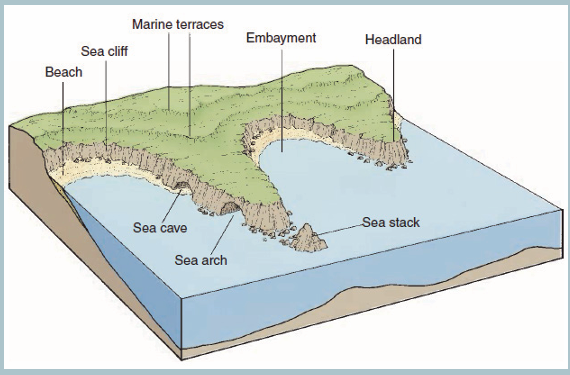
2) Explain the factors for formation of the coastal landforms identifiedon the figure.
4.1. Coastal landforms: Definition of key terms and types of waves
1. Make a research and show the difference between the following
terms related to coastal landforms:
a. Coast
b. Shore
c. Wave
d. Longshore drift
2. Mention the type of waves
Learning activity 4.1
4.1.1. Definition of key terms
The following are definitions of some terms related with coastal landforms:
• Coast: A coast refers to the land that borders the sea or the ocean.
It is a narrow zone where the land and the sea overlap and directly
interact. Some coasts are made up of broad sandy beaches, while
others form rocky cliffs or low-lying wetlands. The shape of the coastline
is determined by factors such as the types of rocks present, the forcesof erosion, and the changes in sea level.
• Shore: This is the area where land meets the sea or ocean. Different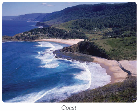
features are found in this area resulting from erosion and deposition of
sediments, ocean or sea waves, as well as the effects of rivers as they
join the sea. It is also called coastline.
• Waves: Waves are defined as undulations of sea/lake water
characterized by well-developed crests and troughs .Waves are created
by the transfer of energy from the wind blowing over the surface of
the sea or from submarine shock waves by earthquakes or volcanic
activities (e.g. Tsunami).
• When waves appear with high frequency they demonstrate the shortwavelengths.
Structure of wave
Longshore drift, often used interchangeably with beach drifting, is a general
term for sediment transport parallel to shore in the nearshore zone due to
incomplete wave refraction. In this process sediments transported by the river
systems are moved by ocean waves and ocean currents to form beaches.
Beach drifting, also called littoral drifting, is a process in which waves breaking
at an angle to the shoreline move sediment along the beach in a zigzag fashionin the swash zone. Both processes are illustrated on figure below.
A wave approaching a straight coastline at a large angle will have velocity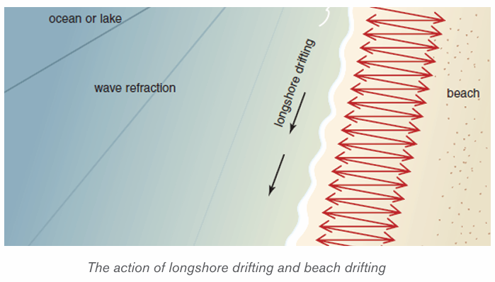
progressively decreasing. This will cause the wave to swing around, but it may
not have enough time to conform fully to the shape of the shoreline beforebreaking, leading to littoral drifting.
4.1.2. Types of waves
There are two main types of waves: constructive waves and destructive waves.
1. Constructive waves: These are waves whose swash is more powerful
than backwash. They are depositional in nature.
2. Destructive waves: These are waves whose backwash is more powerful
than swash. They are erosional in nature.
Other types of waves
– Breaking waves: Formed when the wave collapses on top of itself.
There are four types of breaking waves: spilling, plunging, collapsing, and surging.
Spilling Waves
Spilling waves are waves that are produced when the ocean floor has a gentle
slope. As the wave approaches the shore, it slowly releases energy, and the
crest gradually spills forward down its face until it is all whitewater. These waves
take more time to break than any other wave. Surfers usually call these waves,
“mushy waves.”
Plunging Waves
Plunging waves are formed when the incoming swell hits a steep ocean floor or a
sea bottom with sudden depth changes. As a result, the wave’s crest curls over
and explodes on the trough. The air under the lip of the wave is compressed,
and a crashing sound is often heard. Plungers are more common in offshore
wind conditions.
Surging Waves
Surging waves are produced when long period swells arrive at coastlines with
steep beach profiles. The base of the wave moves fast and does not allow the
crest to evolve. As a result, the wave almost doesn’t break, and there is little
whitewater. Surging waves look friendly, but can be quite deadly because of the
backwash associated with them.
Collapsing Waves
Collapsing waves are a blend between surging and plunging waves. The crest
never completely breaks, and the bottom face of the wave gets vertical and
collapses, resulting in whitewater.
– Deep water waves/Swell waves: Are made up of a number of waves
of different lengths superimposed on each other. They are straight and
long, powerful, and travel great distance.
– Inshore waves: These waves drain the beach as a backwash.
– Internal waves: Formed due to the disturbances found between two
water masses of different density. They are high and become turbulent
currents when they hit a landmass.
– Kelvin waves: Formed due to lack of winds in the Pacific Ocean. They
are high and wide waves, warmer than the surrounding water.
– Progressive waves: Move with a steady speed, so they are called
Progressive Waves. They are of two types:
– Capillary waves: Formed when wind creates pressure over capillarity,
the binding force that holds the water molecules of the ocean surface
together.
– Orbital progressive waves: Formed at the boundary of two liquids
with different density.
– Refracted waves: Travel in shallow water when they approach the
shore. The shallowness decreases the power of the wave and causes
a curve. These are usually seen near headlands and bays.
– Seiche waves: Caused due to the movement within a confined space.
These have long wavelengths and rarely result in any damage as their
height is generally short.
– Shallow water waves: Move in shallow waters. They are of two kinds:
• Tidal waves: Formed due to the gravitational pull of the sun and
the moon on the ocean.
• Seismic Sea Waves/tsunami: Caused due to earthquakes
beneath the ocean. They travel extremely fast in open water, have
significant height in shallow water, and are very dangerous and
devastating.
– Swell waves/Surging waves: Intense waves generating from the
center of a storm where the winds are strong. These expel little energy,travel long distance, and break on distant shores.
Application activity 4.1
1. Differentiate a constructive wave from a destructive wave.
2. If you find an occasion to visit the ocean coast as an East Africa
person, describe the coastal features you would be interested todiscover and explain why.
4.2. Factors determining the strength of waves and wave
action processes
Learning activity 4.2
1. Analyse the factors that determine the strength of waves on the coast2. Explain how waves can cause erosion along the coast.
4.2.1. Factors determining the strength of waves
The following are the major factors determining the strength of waves.
– Wind strength: Wind must be moving faster than the wave crests for
energy transfer to continue;
– Wind duration: Winds that blow for a short time will not generate
large waves;
– Fetch: The uninterrupted distance over which the wind blows without
changing direction;
– Depth of water or roughness of sea bed: As waves enter shallow
water, their speed, wavelength and height increase. Therefore waves
tend to break in shallow water, for example over a bar at the entrance
to a harbor;
– Direction and speed of tide: If the tide direction is against the wind,this will also increase wave height and decrease wavelength.
4.2.2. Wave action processes
The wave action includes erosion, transportation and deposition.
• Erosion: Several mechanical and chemical effects produce erosion of
rocky shorelines by waves. Depending on the geology of the coastline,
nature of wave attack, and long-term changes in sea-level as well as
tidal ranges, erosional landforms such as wave-cut, sea cliffs, and even
unusual landforms such as caves, sea arches, and sea stacks can form.
They erode in four ways as:
1) Solution: it is also called corrosion. It is common on coasts composed
of soluble rocks such as limestone and rock salt.
2) Corrosion or abrasion: this is a type of wave erosion in which the load
already weathered down and hence being transported drag itself on the
bed of the coast and hence wears away some rock particles.
3) Attrition: this is a process of wave erosion which involves the reduction
in size of eroded particles by themselves.
4) Hydraulic action: this is the direction of breaking waves that push water
on a cliff. As this water retreats during a backwash, pressure is suddenly
released and this generates shock waves that weaken rock particles and
make them easily eroded by a backwash.
• Transportation: Waves are excellent at transporting sand and small
rock fragments. These, in turn, are very good at rubbing and grinding
surfaces below and just above water level in a process known as
abrasion. Longshore drift, longshore currents, and tidal currents in
combination determine the net direction of sediment transport and
areas of deposition.
• Deposition: Sediments transported by the waves along the shore
are deposited in areas of low wave energy and produce a variety of
landforms, including spits, tombolo, beaches, bars and barrier
islands. Different types of pediments are deposited along a coast,
sometimes in the form of an accumulation of unconsolidated materialssuch silt, sand and shingle.
Application activity 4.2
1) Wave erosion is done in four ways, differentiate them2) Explain the impact of wind and tides on the strength of the waves.
4.3. Factors for Formation of coastal landforms and
landforms produced by wave and their importance
Learning activity 5.3
In section 4.2, we have defined key terms related to coastal landforms.Observe carefully the following figure and answer the following questions:
1) Identify the landforms produced by wave erosion on the figure above.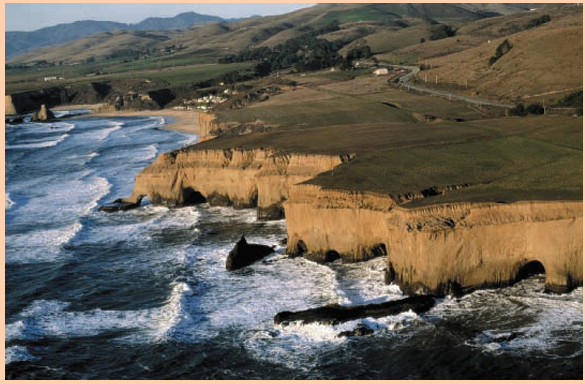
2) Explain the factors that result in the formation of coastal landforms.
4.3.1. Factors influencing the formation of coastal landforms
The following are the major factors influencing the formation of coastal landform:
– Tides: Tides are greatly influencing forces of coastal landforms.
They are commonly semi-diurnal (12-hour cycle). The rise and fall of
water levels produce oscillating currents known as tidal streams. Tidal
currents can transport large quantities of sediments, especially at the
mouths of estuaries. The tidal amplitude also determines the sediments
deposition or erosion and keeps redefining the shoreline of coastal
landforms.
– Nature of rocks at the coast: Wave erosion is more pronounced on
areas that are weak and soluble e.g. jointed and consolidated rocks.
Rocks which are strong and highly consolidated are hard to erode. The
hard and resistant rocks stand as headlands while easily eroded rocks
become bays.
– Openness of the shore to wave attack: Coasts which are totally
exposed to wave attack are easily undermined by wave attack while
those which are sheltered by coastal reefs and islands are protected
from direct wave attack and are hence less eroded.
– Waves: Waves contribute to the erosion of shore. The greater the wave
action, the higher is the erosion and sediment movement. Where the
shoreline is long and flatter, the wave energy gets dispersed. Wherever
there are rock formations, cliffs and short shore area, the wave energy
is high. Strong waves can pick up sediments from deeper waters and
make them available for transportation by the coastal currents. The
larger the wave, the larger the particle it can move. Storm waves can
even move boulders. Even small waves can lift the sediments and
deposit along the coastal shoreline.
– Abundance and size of loads which is used as an abrasive
tool: When materials e.g.; boulders, sands, etc. are in abundance, the
coast line will be easily eroded through corrosion. In the absence of
such materials, wave erosion becomes meager.
– Longshore currents: Parallel movement of water is known as
longshore current and it extends up to the zone of breaking waves
from the coastal shoreline. As the long shore currents are formed by
refracting waves, the direction of flow will depend upon the angle of
the wave which in turn depends upon the wind directions. If the wind
direction is balanced, the sediment movement is also balanced. If the
wind movement and resultant wave action dominate in one direction
great volumes of sediment may be moved in one direction.
– Weather elements: The elements of climate, such as wind, rainfall and
temperature play an important role in formation of coastal landforms.
Winds are directly related to the intensity of waves. Landforms like
coastal dunes are created by wind action. Temperature is required for
physical weathering of sediments. Rainfalls provide runoff for producing
and transporting sediments from land to seashore.
– Gravity: Gravity is an important factor for the development of coastal
landforms. Gravity is indirectly involved in the movement of wind and
waves as well as in downward movement of sediments.
– Nature of coastal rocks: Soft rocks are easily eroded hence forming
erosional features like bays while hard or resistant rocks lead to theformation of headlands.
4.3.2. Landforms produced by wave erosion (destructive wave)
The coastal features formed due to marine erosion by sea waves and other
currents and solution processes include cliffs, caves, geo, stacks, blowhole,
arch, wave-cut platforms.
– Cliffs: A cliff is a steep rocky coast rising almost vertically above
sea water. Cliffs are very precipitous with overhanging crest. The
steepness of vertical cliffs depends on the following: lithology of the
area, geological structure, weathering, erosion of cliff faces and marine
erosion of cliff base.
– Wave-cut platform: Rock-cut flat surfaces in front of cliffs are called
wave-cut platforms or simply shore platforms. They are slightly concave
upward. The origin and development of wave-cut platforms is related to
cliff recession. The plat-form is composed of bare rock or it may containa temporary deposit or rock debris, pebbles or sand.
– Sea caves: A sea cave is a natural cavity or chamber which develops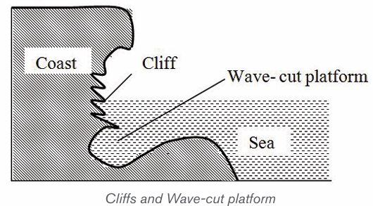
along the coast due to gradual erosion of weak and strongly jointed
rocks by up rushing breaker waves (surf currents). Sea caves are more
frequently formed in carbonate rocks (limestone and chalks) because
they are eroded more by solution processes. However, sea caves are
not permanent as they are destroyed with time.
– Headland: Is a projection of land into the sea or lake. Where alternate
hard and soft rocks occur at the coast, the weak material is eroded to
form a bay while the harder rock resists erosion and remains extending
out into the water as a headland.
– Blowhole: This is a vertical shaft linking the cave to the surface. It is
formed when wave action attacks the back part of the roof of the cave.
At the same time, weathering by solution acts on the line of weaknessfrom the surface downwards to form a blowhole
– Geo: Wave erosion may continue on the roof of the cave along the
blowhole. Hence, the roof of the cave may collapse to form a long andnarrow sea inlet known as Geo.
– Stack/ Column/Pillar: A stack is an isolated rock monolith or pillar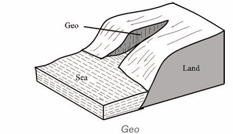
rising steeply from the sea. It is a former part of the adjoining land that
has become isolated from it by wave erosion, probably after havingformed part of a marine arch.
– Sea arch: A sea arch is a natural opening through a mass of rock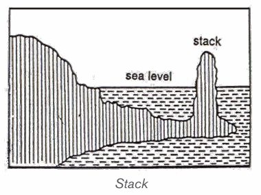
limestone or boulder clay. It is most commonly seen on the sea coast
where waves have cut through a promontory. When the keystone of themarine arch collapses, the feature will become a stack.
4.3.3. Landforms produced by wave deposition (constructive wave)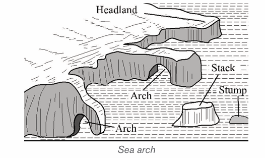
Sediments transported along the shore are deposited in areas of low wave energy.
They produce a variety of landforms, including spits, tombolo, beaches,
bars and barrier islands. Different types of pediments are deposited along
a coast, sometimes in the form of an accumulation of unconsolidated materials
such as silt, sand and shingle.
• Spits: A spit is an embankment composed of sand and shingle attached
to the land on one end and projecting seaward. It may form parallel to
the coast and stretch several kilometers. It may also grow at an angle
across an estuary. Spits are formed when materials are transported and
deposited by the long shore drift, mostly where the orientation of thecoast changes.

•
Tombolo: It is a spit which grows seawards from the coast andjoints to an island.
• Beaches: A beach is located on a wave-cut platform of solid rock and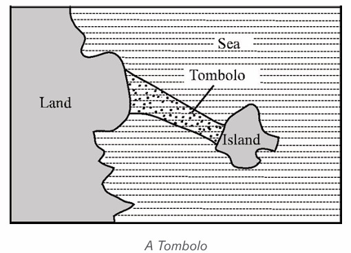
is generally of a low gradient with a gently concave platform. Beaches
may extend for hundreds of kilometers. Beaches are classified into:sand beach, shingle beach, and boulder beach.
Different elements of a beach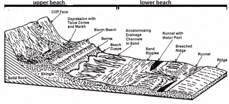
• Bar: A bar is an elongated deposit of sand, shingle or mud occurring
in the sea. It is more or less parallel to the shoreline and sometimes
linked to it. Bars may be of submerged or emergent embankments of
sand and gravel built along the shore by waves and currents. One ofthe most common types of bars is the spit.
• Barrier Islands: Barrier Islands are long, offshore islands of sediments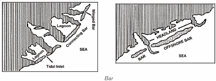
tending parallel to the shore. They form long shorelines adjacent to
gently sloping coastal plains, and they are typically separated from the
mainland by a lagoon. Most barrier islands are cut by one or more tidalwaves.
• Cuspate foreland: This is a large triangular-shaped deposit of sand,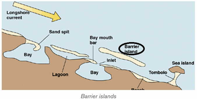
mud and shingles projecting seaward. It is a rare feature formed when
two adjacent spits growing towards each other at an angle join andenclose a shallow lagoon.
• Mud flats: These are platforms of mud, silt and river alluvium kept by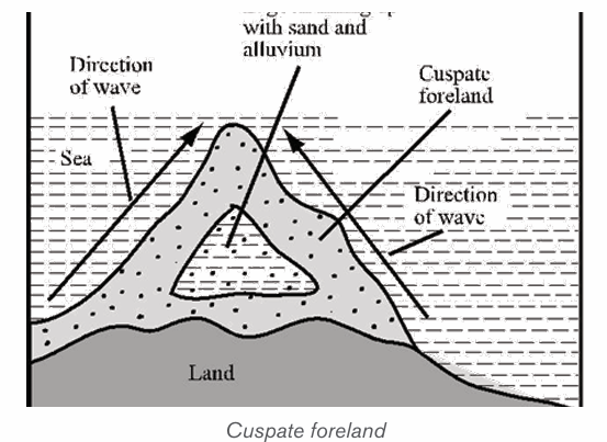
salt-tolerant plants to form a swamp or marshland. They are formed
when tides deposit fine silts along gently sloping coats in bays andestuaries.
• Coastal dunes: These are low-lying mounds of fine sand, deposited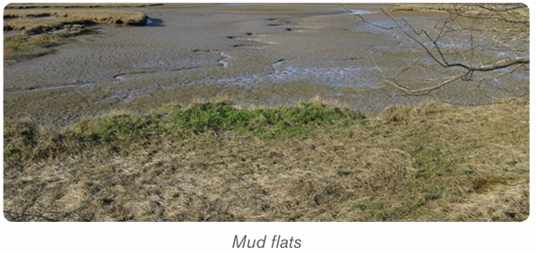
further inland from a wide beach by strong onshore winds. They arecommon in arid and semi-arid coasts.
Application activity 4.3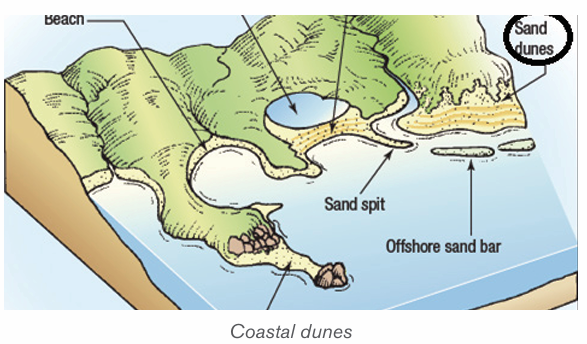
1) Describe landforms produced by wave deposition.
2) Explain the factors influencing the formation of coast landforms.
3) According to you, which landforms are likely to be found around lakesin Rwanda ?
4.4. Importance of coast landforms produced by wave
action and type of coasts
Learning activity 4.4Study the following photograph and answer related questions:
1. Describe the types of coasts.
2. Describe the economic activities that can be carried out in this area
4.4.1. Importance of coast landforms produced by wave
Coastal landforms produced by wave action are very important in different ways
as follows:
– Many of the world’s major cities are located in coastal areas, and a
large portion of economic activities, are concentrated in these cities.
– There are different activities that take place in coastal zones including
coastal fisheries, aquaculture, industry, and shipping.
– Many of coastal landforms are very favourable for tourism that contributes
to the economic development of countries.
– Marine, estuary and coastal wetland areas often benefit from flows of
nutrients from the land and also from ocean upwelling which brings
nutrient-rich water to the surface. They thus tend to have particularly
high biological productivity.
– The world’s fish production is dependent on the nature of coastal
landforms like bays and headlands.
– Beaches support leisure, recreation, trade and mining of sand
– Mud flats and sand dunes have fine silt which attracts mangrove
swamps used in crafts industry.
– Features produced are important in agriculture development
– Cliffs protect the land from wave attack.
– These landform features are used in study purposes.– Cliffs may produce waterfalls important in generation of power.
4.4.2. Types of coasts
There are two types of coasts: Submerged coasts and Emerged coasts.
i) Submerged coasts
Submerged coasts fall into two categories: Submerged upland coasts and
submerged lowland coasts.
A. Submerged upland coasts
When the margin of an irregular upland area is submerged, a more or less
indented coastline is produced. It appears with islands and peninsulas
representing the former uplands, and with inlets indicating the former valleys.
The following are the three types of submerged coasts:
1) Ria coasts: Ria is a Spanish term widely used to describe a submerged
coastal valley or estuary resulting from a rise of the sea level. In the case
of a Ria coast, hills and river valleys meet the coastline at right angles.
The rias are characterized by funnel-shaped which decreases width
and depth as they run inland. The head of a stream which is small isresponsible for the formation of the valley at the inlet.
2) Fiord (Fjord) coasts: A long, narrow inlet of the sea bound by steep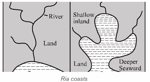
mountain slopes. These slopes are of great height and extend to
considerable depths (in excess of 1,000 m) below sea level. It is formed
by the submergence of glacially over deepened valleys due to a rising
sea level after the melting of the Pleistocene ice sheets. Fiords occur
in western Scotland, Norway, Ireland, Greenland, Labrador, British
Columbia, Alaska, Southern Chile and New Zealand. The main reason
for their existence is the submergence of deep glacial troughs and that iswhy fiords have many characteristics of glaciated valleys.
3) Dalmatian or longitudinal coasts: Dalmatian is a term derived from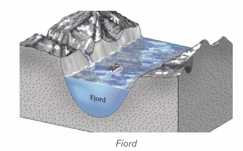
the Yugoslavia Adriatic in which the coast runs parallel with the lineament
of the topography and probably with the underlying geological structure.
A rise of sea level (estuary) has drowned the coastal area, resulting in
a coastline of narrow peninsulas, lengthy gulfs and channels and linearislands. The Dalmatian coast tends to be straight and regular.
4) Submerged lowland coasts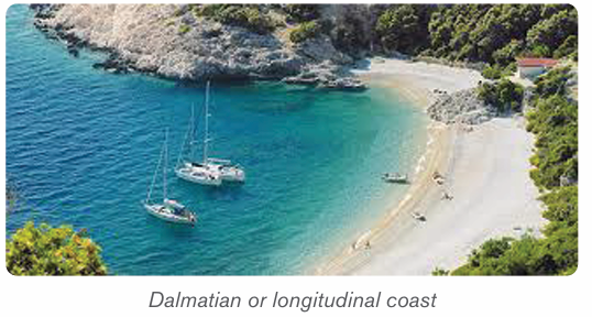
These are formed when a rise in the sea level drowns a lowland coast. The
sea penetrates deep inland along rivers to form estuaries. The rise in base level
causes an increase in deposition by rivers leading to formation of mud flats,
marshes, and swamps which are visible at low tides. Delta: Is a large, flat and
low lying plain of river deposits laid down where a river flows to the sea or lake.A delta is a large area covered by river deposits (alluvium) formed at the mouth of a river
Ii) Emerged coasts
Emerged coasts comprise emerged highlands coasts and emerged lowland
coasts.
A. Emerged upland coasts
Raised beaches: when the sea level drops, wave activity also drops to lower
levels. The wave deposition will be at a new point of low tide level forming a new
beach there, hence leaving the old beach up high at a former point of sea. These
types of beaches are usually evident on land that is far away from the present
edge of the water. They may have been formed at the head of a bay but they are
now isolated on land. Most raised beaches are colonized by vegetation.
Raised cliffs: this is formed when there is a relative fall in the level of the sea.
A raised terrace: the drop in sea level produces a wave cut platform down to
a new level of the sea leaving the former terrace suspended up to the originallevel of the sea before emergence.
B. Emerged lowland coasts
An emerged lowland coast has been produced by the uplift of part of the
neighboring continental shelf. The landward edge of such coastal plain is found
in the southern of USA. It is formed by the fall-line where rivers descend from
the Appalachian in a series of waterfalls. Other examples of emerged lowland
costs are: the northern shore of the Gulf of Mexico and the southern shore ofthe Rio-de-la Plata in Argentina.
Application activity 4.4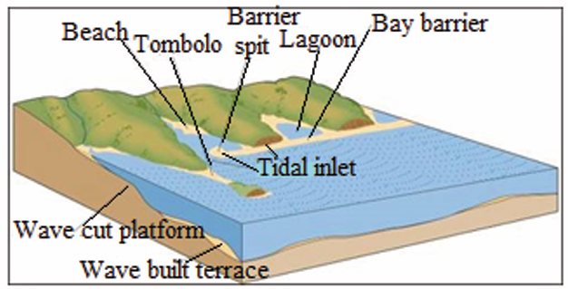
1. Give five examples of cities located in coastal areas, including at least
two cities located in East African Community.
2. Indicate the type of submerged coast, and describe its characteristics.
3. Suppose that you live nearby the coast, explain the business
opportunities that you may carry out there and the challenges you can face.
4.5. Coral reefs: Nature, types and formation of coral reefs
Learning activity 4.5
Observe the figure below of a coral reef and answer the following questions:answer the following questions:
1. What do you think are the elements that constitute a coral reef?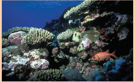
2. Analyze the processes in which coral reefs are formed.
3. What do you think are the problems related to coral reefs formation?
A coral is a hard limestone rock made up of the skeletons of tiny (very small)
marine organisms, known as coral polyps. Also coral reefs are limestone rocks
which are formed from dead animals called corals. Corals have a hard shell of
calcite, formed by the extraction of calcium carbonate from sea water.
They are generally attached to submarine platforms or islands submerged underseawater.
A. Types of coral reefs
On the basis of the location of the main types of reefs, we distinguish tropical
coral reefs and marginal belt coral reefs. But, by categorizing on the basis of
the nature, the shape and the mode of occurrence, we have three types of coralreefs which are: fringing reefs, barrier reefs and atoll.
1) Fringing reefs (Shore Reefs): These are the coral reefs developed
along the continental margins or along the islands. The seaward slope is
steep and vertical while the landward slope is gentle. A fringing reef runs
as a narrow belt which grows from the deep sea bottom sloping steeply
seaward side. It is separated from the main land by a narrow and shallow lagoon.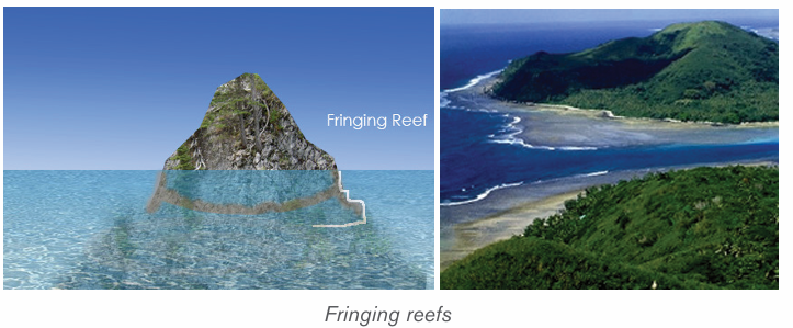
2) Barrier reefs: Barrier reefs are extensive linear reef complexes that areparallel to a shore and are separated from it by a deep and wide lagoon.
3) Atoll: An atoll is a roughly circular (annular) oceanic reef system
surrounding a large and often deep central lagoon. There are three types
of atolls, namely, true atolls, island atolls and coral island or atoll islands.
– True atolls are characterized by circular reef enclosing a shallow
lagoon but without an island;
– Island atolls have an island in the central part of the lagoon enclosed
by circular reefs;
– Coral islands or atoll islands do not have islands in the beginning but
later on islands are formed due to erosion and deposition by marine waves.
B. Formation of coral reefs
1) The process of coral reefs formation
Coral reefs start to form when the free-swimming coral larvae attach to the
submerged rocks or other hard surfaces along the edges of islands or continents.
This continues to grow under the influence of coral reefs conditions to grow in
any types accordingly. The coral reef formation takes three stages: fringing,barrier and atoll.
Concerning the process, a typical fringing reef is attached to or borders the
shore of a landmass, while a typical barrier reef is separated from the shore by
a body of water. An atoll began as a fringing reef around a volcanic island. Over
time, the volcano stopped erupting, and the island began to sink. Over time,
coral growth at the reef’s outer edge would push the top of the reef above the
water. As the original volcanic island disappeared beneath the sea, only an atollwould remain.
1) The general conditions influencing coral formation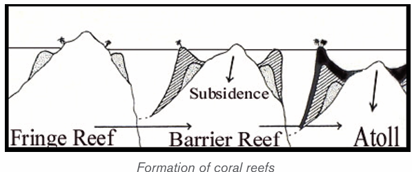
• Corals are found mainly in the tropical oceans and seas because they
require high mean annual temperature ranging between 20°C and
21°C for their survival. They cannot survive in the waters having either
very low temperature or very high temperature.
• Corals do not live in deep waters, that is, not more than 60-77 meters
below the sea level.
• There should be clean sediment-free water because muddy water or
turbid water clogs the mouths of coral polyps resulting into their death.
• Though coral polyps require sediment-free water, fresh water doesn’t
allow their growth. This is why corals avoid coastal lands and live away
from the areas of river mouths.
• High salinity is injurious to the growth of coral polyps because such
waters contain little amount of calcium carbonates whereas lime is
important food of coral polyps. The oceanic salinity ranging between
27% and 30% is most ideal for the growth and development of coral polyps.
• Ocean currents and waves are favorable for corals because they bring
necessary food supply for the polyps.
• There should be extensive submarine platforms for the formation of
colonies by the coral polyps. Besides, polyps also grow outward from
the submarine platforms.
• Human activities like deforestation, industrialization cause global
warming, which adversely affects corals in their habitats. Corals are
more susceptible to long-term climatic change. Corals are generally
termed as rainforests of the oceans. These cannot survive in extremewarm environment.
Application activity 4.5
1) Using illustrative graphics, differentiate the types of coral reefs.2) Explain the conditions for coral reefs formation.
4.6. Theories of the origin of coral reefs, Problems facing
the development and growth of coral reefs, Impact of coral reefs
Learning activity 4.6
1. Using concrete examples, show how coral reefs are important2. Mention the theories explaining the formation of coral reefs
4.6.1. Theories of the origin of coral reefs
There are three main theories about the origin of coral reefs that are:
• The subsidence theory by Darwin,
• Antecedence theory by Murray,• Glaciated control theory by Daly.
A. Darwin’s Theory or subsidence theory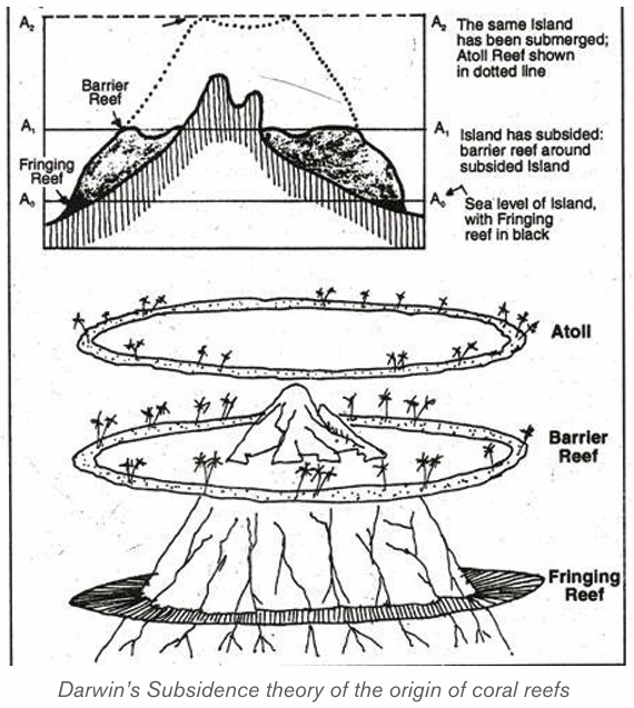
Darwin, a British naturalist developed his theory as follows:
– Darwin’s theory starts with a volcanic island which becomes extinct.
– As the island and ocean floor subside, coral growth builds a fringing
reef, often including a shallow lagoon between the land and the main reef.
– As the subsidence continues, the fringing reef becomes a larger barrier
reef further from the shore with a bigger and deeper lagoon inside.
– Ultimately, the island sinks below the sea, and the barrier reef becomesan atoll enclosing an open lagoon.
B. Murray’s theory or antecedence theory
The Antecedent-Platform or uplift theory for the origin of coral reefs stipulates
that:
– Any bench or bank that is located at a proper depth within the circum
equatorial coral-reef zone is potentially a coral-reef foundation.– If ecological conditions permit, a reef may grow to the surface from
such a foundation without any change in sea-level.
– Reef foundations, or platforms, are formed by erosion, deposition,
volcanic eruption, or earth movement or by combinations of two or
more of these processes.
– The theory agrees that atoll coral reefs formed when the tops of islandswere undergone wave action resulting to a platform.
C. Daly’s theory or glaciated control theory
Daly studied the coral reefs of Hawaii and he was greatly impressed by two
things:
– The reefs were very narrow and there were marks of glaciations
– There should be a close relationship between the growth of reefs and
temperature.– According to Daly’s hypothesis, in the last glacial period, an ice sheet
had developed due to the fall in temperature. This caused a withdrawal
of water, equal to the weight of the ice sheet. This withdrawal lowered
the sea level by 125-150 m.
– The corals which existed prior to the ice age had to face this fall in
temperature dining this age and they were also exposed to air when
the sea level fell. As a result, the corals were killed and the coral reefs
and atolls were planed down by sea erosion to the falling level of sea
in that period.
– When the ice age ended, the temperature started rising and the ice
sheet melted. The water returned to the sea, which started rising. Due
to the rise in temperature and sea level, corals again started growing
over the platforms which were lowered due to marine erosion.
– As the sea level rose, the coral colonies also rose. The coral colonies
developed more on the circumference of the platforms because food
and other facilities were better available there than anywhere else.
– Hence, the shape of coral reefs took the form of the edges of submerged
platforms, a long coral reef developed on the continental shelf situated
on the coast of eastern Australia. Coral reefs and atolls developed on
submerged plateau tops. After the ice age, the surface of platforms
was not affected by any endogenic forces and the crust of the earthremained
4.6.2. Impact of coral reefs
Coral reef landforms have crucial impact in world economic activities.
These are:
– Tourist attraction: Coastal features like caves, beaches and arches
are tourist attractions.
– Development of harbors: Rias and fiords favor the development of
deep sheltered harbors.
– Industrial raw materials: Coral limestone provides raw materials for
the manufacture of cement. This is obtained from raised coral reefs.
– Fishing grounds: Fiords contain sheltered waters which are suitable
for feeding and development of fishing ports. Continental shelves
contain shallow waters which favor growth of planktons. This makes
them rich fishing grounds.
– Habitat for marine life: Lagoons, mud flats and mangrove swamps
are good habitats for marine life. This has promoted the development of
research on marine life and establishment of marine parks.
– Impact on agriculture: emerged coasts have sand, gravel and bare
rock. These inhibit agriculture, especially crop farming.
– Transport barrier: coastal features such as sandbars and coral reefsinhibit water transport and development of ports.
4.6.3. Problems facing the development and growth of coral reefs
The following are the major problems facing the development and growth of
coral reefs:
– Overfishing: Increasing demand for food fish and sea tourism has
resulted in over fishing of not only deep-water commercial fish, but
key reef species as well. This affects the reef’s ecological balance and
biodiversity.
– Coral disease: coral diseases contribute to the deterioration of coral
reef communities around the globe. Most diseases occur in response
to the onset of bacteria, fungi, and viruses.
– Destructive fishing methods: Fishing with dynamite, cyanide
and other methods that break up the fragile coral reef are highly
unsustainable. Dynamite and cyanide stun the fish, making them easier
to catch. Damaging the coral reef habitat on which the fish rely reduces
the productivity of the area.
– Unsustainable tourism: Physical damage to the coral reefs can occur
through contact from careless swimmers, divers, and poorly placed
boat anchors. Hotels and resorts may also discharge untreated sewage
and wastewater into the ocean, polluting the water and encouraging
the growth of algae, which competes with corals for space on the reef.
– Coastal development: The growth of coastal cities and towns
generates a range of threats to nearby coral reefs. Coral reefs are
biological assemblages adapted to waters with low nutrient content,
and the addition of nutrients favours species that disrupt the balance of
the reef communities.
– Pollution: Coral reefs need clean water to thrive. From litter to waste
oil, pollution is damaging reefs worldwide. Pollution from human
activities inland can damage coral reefs when transported by rivers into
coastal waters.
– Marine debris: It is any solid object that enters coastal and ocean
waters. Debris may arrive directly from a ship or indirectly when washed
out to sea via rivers, streams, and storm drains. Human-made items
tend to be the most harmful such as plastics (from bags to balloons,
hard hats to fishing line), glass, metal, rubber (millions of tires!), and
even entire vessels.
– Dredging operations. They are sometimes completed by cutting a
path through a coral reef, directly destroying the reef structure and killing
any organisms that live on it. Operations that directly destroy coral are
often intended to deepen or otherwise enlarge shipping channels or
canals, due to the fact that in many areas, removal of coral requires a
permit, making it more cost-effective and simple to avoid coral reefs if
possible.
– Global Aquarium Trade: It is estimated that nearly 2 million people
worldwide keep marine aquariums. The great majority of marine aquaria
are stocked with species caught from the wild. This rapidly developing
trade is seeing the movement of charismatic fish species across borders.
Threats from the trade include the use of cyanide in collection, over
harvesting of target organisms and high levels of mortality associated
with poor husbandry practices and insensitive shipping. Some regulation
is in place to encourage the use of sustainable collection methods and
to raise industry standards.
– Alien invasive species: Species that, as a result of human activity,
have been moved, intentionally or unintentionally, into areas where they
do not occur naturally are called “introduced species” or “alien species”.
In some cases, where natural controls such as predators or parasites
of an introduced species are lacking, the species may multiply rapidly,
taking over its new environment, often drastically altering the ecosystem
and out-competing local organisms.
– Climate change: Rising sea levels due to climate change requires coral
to grow to stay close enough to the surface to continue photosynthesis.
Also, water temperature changes can induce coral bleaching in which
sea surface temperatures rose well above normal, bleaching or killing
many reefs.
– Ocean acidification: results from increases in atmospheric carbon
dioxide. The dissolved gas reacts with the water to form carbonic acid,
and thus acidifies the ocean. This decreasing pH is another issue for
coral reefs.
– Coral mining: Both small scale harvesting by villagers and industrial
scale mining by companies are serious threats. Mining is usually done
to produce construction material which is valued as much as 50%
cheaper than other rocks, such as from quarries. The rocks are ground
and mixed with other materials, like cement to make concrete. Ancient
coral used for construction is known as coral rag. Building directly on
the reef also takes its toll, altering water circulation and the tides whichbring the nutrients to the reef.
Application activity 4.6
1. Establish the similarities of the subsidence, antecedence and
glaciated control theories of coral reefs formation.
2. Account for the negative impacts of human activities on the coral
reefs growth.3. Describe the economic importance of coral reefs.
4.7. Sea level change
Learning activity 4.7Observe the following picture and answer the question that follow:
1. Find evidence that the level of water on this picture changes.
2. What do you think can cause that change?
3. Describe any three features observed on this picture
4.7.1. Meaning of sea level change and its resulting features
The sea level change is the variation and fluctuation of the sea level throughout
time. It can contribute to the formation of submergent landforms such as Ria
(a river valley that’s been flooded by the eustatic rise in sea level), fjords and
dalmatian coastline, and emergent landforms such as raised beaches. These
are wave-cut platforms and beaches that are above the current sea level. There
are also some old cliffs (relic cliffs) behind these raised beaches with wave-cutnotches, arches and stacks along them.
4.7.2. Types of sea level changes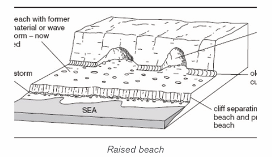
There are two types of sea level changes which are:
• Submergence or Rise of sea level: This is referred to as an increase
in global mean sea level as a result of an increase in the volume of water
in the world’s oceans. This leads to the formation of coastal features of
submergence.
• Emergence or fall of sea level: This is referred to as the decrease in
global mean sea level as a result of a decrease of the world’s oceans.This leads to the production of emergence coastal landform.
4.7.3. Causes of sea level change
The sea level changes daily because of the following causes:
– Eustatic variations in sea level are the effects of external forces.
Most experts agree that human induced global warming is the force
behind the current global sea-level rise. There are three factors that
primarily affect eustatic sea level change that are: thermal expansion of
the ocean, melting of nonpolar glaciers, and change in the volume of
the ice caps of Antarctica and Greenland.
– The changes in global temperature affect the amount of ice stored
on land as water, thus changing the sea levels. A rise in temperatures
causes the ice caps to melt, and sea levels rise, and vice versa.
– The changes in sea levels are also affected by the steric effect.
This is where the density of the water increases or decreases as the
temperature rises or falls. If the temperature rises the water expands
and if it falls the water contracts. It is estimated that sea levels can rise
up to 0.4 mm per year.
– The mass of ice adds weight to the earth’s crust causing it to sink
lower into the mantle resulting into relative rise in the sea-level during
glacial period.
– Isostatic re-adjustment; at the end of glacial period, the mass of ice
melts and the weight is lost from crust which then rises. When the ice
melts the land begins to rise as the weight is removed. This process
results in a relative fall in sea-level. This is called isostatic re-adjustment.
– Uplift/mountain building due to plate movements may also result in
a relative fall in sea-level as land rises up.
– Pre-glacial erosion of a coastline causes the coast rise and endup to the sea level change.
4.7.4. Evidences of sea level changes
The following are evidences of sea level changes:
– The presence of old coastline high above the present sea level:
During the Ice Age the sea levels fall leaving the old coastline. Since
the end of the Ice Age, sea levels have risen again, but not to their
previous levels. The raised beaches continue to be above the present
sea level by quite a distance.
– The estuaries and inlets flooded: Sea level rise after the last Ice
Age caused estuaries and inlets to be flooded. This occurred in South
West England, drowning many river valleys around the coasts of Devon
and Cornwall, and creating Rias. In other more northern areas, glacial
valleys were drowned to create Fjords.
– Isostatic re-adjustment phenomenon: Some places in Scotland
still undergoing isostatic re-adjustment up to 7 mm per year in some areas.
4.7.5. Effects of the sea level changes
Rising sea level has many impacts on coastal areas. The following are some of
them:
– Erosion of beaches and bluffs: Beach erosion is the most common
problem associated with rising sea level. Depending on beach
composition, beaches erode by about 50 to 200 times the rate of sea
level rise. That translates a 2-millimeter (0.08-inch) per year increase
in sea level eroding from 10 to 40 centimetres (3.9 to 15.6 inches)
of coastline per year. Beach erosion has not only a strong ecological
impact, but also a profound economic impact;
– It increases the flooding and storm damage caused by changes
in sea level;
– Contamination of drinking water: as the rising sea crawls farther
and farther up the shore, in many places it will seep into the freshwater
sources in the ground that many coastal areas rely on for their drinking
water. Saltwater is unsafe to drink, and while it is possible to remove
the salt from water, doing so is an expensive and complicated process;
– Interference with farming: Those same freshwater sources we use
for drinking also supply the water we use for irrigation. The problems
here are the same: The intruding sea could make these groundwater
sources saltier. Saltwater can stunt or even kill crops, but creating
freshwater from saltwater is a costly and unsustainable practice;
– Change in coastal plant life: more saltwater hitting the shores
changes the soil composition on the coast, meaning the plant life there
will most likely change as well;
– Threating the wildlife population: Many forms of wildlife make their
home on the beach. As the rising ocean erodes the shoreline and floods
the areas in which coastal animals live, animals like shorebirds and sea
turtles will suffer and die and others will migrate;
– Hurting the economy: the tourism and real-estate industries in
coastal areas are likely to take a hit as prime beachfront properties and
recreational areas are washed away by rising waters. This is a fact thatsome involved in these industries are finding hard to swallow.
Application activity 4.7
1. Explain the causes of sea level change
2. According to you, which feature is more attractive to tourism. Defend
your view3. Explain the environmental effects of sea level changes.
Skills Lab
With help of knowledge and skills acquired in this unit, suggest waysbeaches may be preserved and more productive.
End unit assessment
1) Describe the major features resulting from wave erosion and
deposition processes.
2) Observe the following photographs and answer the questions that follow:
i) Examine the economic activities that should be carried out in the
regions demonstrated on photographs.
ii) According to you, what are the advantages of coast or shore to
people living nearby?
3) Demonstrate the impacts of sea level change to the environment.