General
- Geography SSE Y3 SB File Uploaded 2/11/21, 16:09
- Geography SSE Y3 TG File Uploaded 2/11/21, 16:08
UNIT 3:EXTERNAL LANDFORM PROCESSES AND RELATED FEATURES
Key Unit competence:
By the end of this unit, I should be able to demonstrate an understanding ofdifferent landforms resulting from the external processes.
Introductory activity
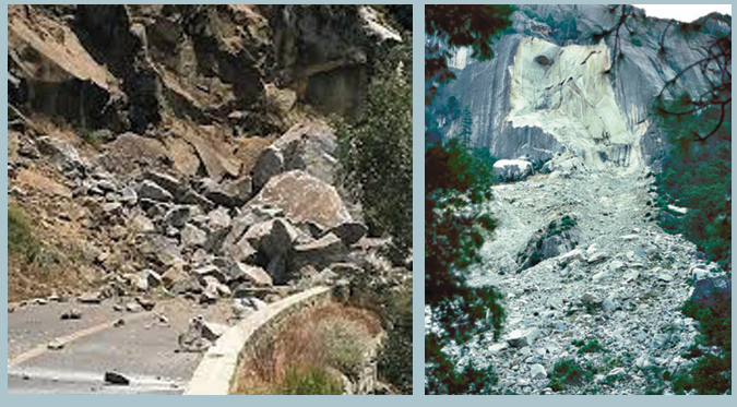
Observe the photographs below and explain the processes that affectedthe rocks that appear on them.
3.1. Definition, types and process of weathering
Learning activity 3.1
1. Differentiate physical weathering from chemical weathering
2. Outline the processes of chemical weathering
3.1.1. Definition of weathering
Weathering refers to the process of disintegration and decomposition of rocks
into small particles by the action of weather and living organisms.
Agents of weathering include the temperature, rainfall (water), wind, animals
and plants (vegetation).
3.1.2. Types of weathering and processes
There are three types of weathering namely physical or mechanical
weathering, chemical weathering and biological weathering which cuts
across each of the physical and chemical weathering.
i) Physical weathering
Physical weathering refers to the breaking down or disintegration of rocks,
without any change in the chemical or mineral composition of the rock being
weathered. Rocks disintegrate into smaller particles but maintain their previous
chemical characteristics. Only the physical size and shape change. Physical
weathering is mostly influenced by temperature changes.
Processes of physical weathering include:
1) Thermal expansion or insolation weathering:
This process is caused by the changing of temperature ranges which
causes differential heating of minerals forming the rock. When heated
dark minerals expand, faster than others resulting in cracking andfragmentation of the rock
2) Exfoliation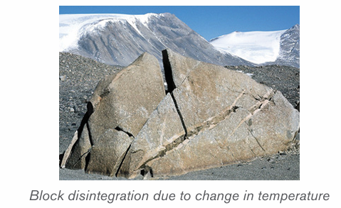
Exfoliation occurs when there is expansion of rocks during the day and
contraction of rocks during the night due to repeated temperature changes.
This process is common in arid and semi-arid regions. This results into rocks
of a few centimeters thick to start peeling off (breaking away) leaving behindexfoliation domes.
3) Freeze thaw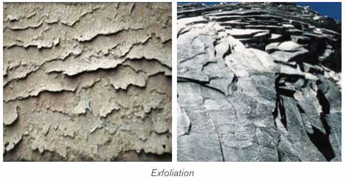
This process also called frost weathering (or frost shuttering) occurs due to
water that enters into the cracks of the rocks; this water freezes and expands
exerting pressure within cracks. Water from rain or melting snow and ice is
trapped in a crack or joint in the rock.
If the air temperature falls below freezing point, the water freezes and expands.
As a result, the rock becomes weak and breaks. This process is common in cold
regions, especially glacial, periglacial and high mountainous zones. The figure
below shows steps from infiltration of water into the rock to the condensationwithin rock fissure which result in the fragmentation.
4) Pressure release
The process of pressure release known as the unloading or dilatation
weathering occurs when materials on top are removed by erosion. This releases
(decreases) pressure, which causes the materials below to expand and crackparallel to the surface.
5) Salt crystallization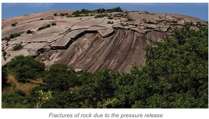
The process of salt crystallization weathering illustrated on the figure below
occurs when saline water (or water carrying salts in solution) passes through
cracks and joints in rocks. As it evaporates, the dissolved salts change into salt
crystals. These crystals expand within cracks as they are heated up and applypressure on the rock leading to its breaking up.
6) Shrinkage weathering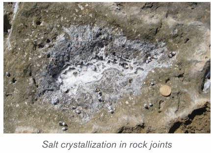
Some clay rocks expand after absorbing water. For instance, there are some
clays which swell when they absorb water during rainy seasons. This results
in increase in their volume. During dry seasons, they massively lose this water
through evaporation and they contract. This process of alternation of expansion
of these rocks during the wet season and contraction of clay during the dry
season is known as shrinkage. This creates stresses and weakness of rocks
causing cracks within the rock.
7) Granular disintegration
This takes place almost in the same way as exfoliation except that in this type,
rocks disintegrate into small particles called granules. It is produced either by
differences in thermal expansion and contraction, or through the frost heaving
process (congeliturbation).
ii) Chemical weathering
This is a type of weathering which involves a complete change in the chemical
and mineralogical composition of the rock resulting into the disintegration of
rocks. It is common in areas which experience alternating wet and dry seasons.
The following are the chemical reactions that take place during weathering:
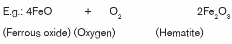
1) Oxidation: oxidation is one of the varieties of chemical weathering
in which oxygen dissolved in water reacts with certain rock minerals,especially iron, to form oxides.
2) Carbonation: This is the process through which rain water dissolves the
atmospheric gases of carbon dioxide (CO2 ) to form a weak carbonic acid
which reacts rocks to wear (weather) them away especially in limestone
areas. After reaction, new compounds are produced as it is shown by thefollowing equation:

3) Dissolution: Dissolution is one of the less important forms of chemical
weathering, in which solid rocks are dissolved by water. When water (e.g.
rainwater) mixes with carbon dioxide gas in the air or in air pockets in soil,
a weak acid solution, called carbonic acid, is produced. When carbonic
acid flows through the cracks of some rocks, it chemically reacts withthe rock causing some of it to dissolve.
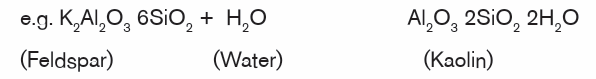
4) Hydrolysis: Hydrolysis involves water combining with rock minerals to
form an insoluble precipitate like clay mineral. Compared to hydration
- a physical process in which water is simply absorbed, the hydrolysis
process involves active participation of water in chemical reactions toproduce different minerals.
5) Hydration: Hydration is one of the major processes of mechanical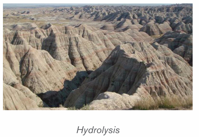
weathering, involving the addition of water to a mineral, causing it to
expand and thereby initiate stress within the rock. For example the
conversion of hematite to limonite. Once minerals have experienced
hydration, they become more susceptible to the effects of chemicalweathering, especially those of carbonation and oxidation.

6) Solution: is a process in which the minerals in the rock directly dissolve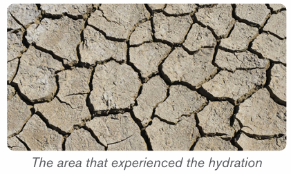
in water without their chemical and mineralogical composition being
altered. e. g. olivine, Rock salt (calcium chloride) and calcium bicarbonate
are easily weathered in solution.e.g. NaCl + H2O → Na+, Cl- (dissolved ions with water).
7) Chelation: Chelation is a form of chemical weathering by plants. It is a
complex organic process by which metallic cations are incorporated into
hydrocarbon molecules. In fact, the word chelate means a coordination
compound in which a central metallic ion is attached to an organicmolecule at two or more positions.
iii) Biological weathering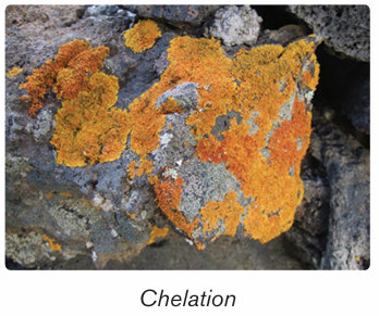
Biological weathering is a process of rock disintegration (decay) due to the
influence of living organisms both growing plants and animals. The diversity of
life in soil includes plants, algae, fungi, earthworms, flatworms, roundworms,
insects, spiders and mites, bacteria, and burrowing animals.
Plants wear away the rocks by their roots which widen the rock joints hence
allowing in other weathering agents like water to disintegrate the rocks. Some
plant roots also have chemicals at the tips of their roots which are acidic and
hence cause rock weathering.
Tree roots find their way into cracks or joints in the rocks. As they grow, they
cause the joints to become bigger. The end result is that the rocks break intosmaller pieces at some points.
Burrowing animals like rodents and moles, warthogs (wild pigs) and wild animals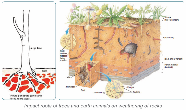
in game parks like the chimpanzee, excavate the rocks and as such, they break
up the rocks hence weathering them. Man also disintegrates rocks through hisactivities.
Man’s activities such as mining, construction, quarrying, agriculture, etc. result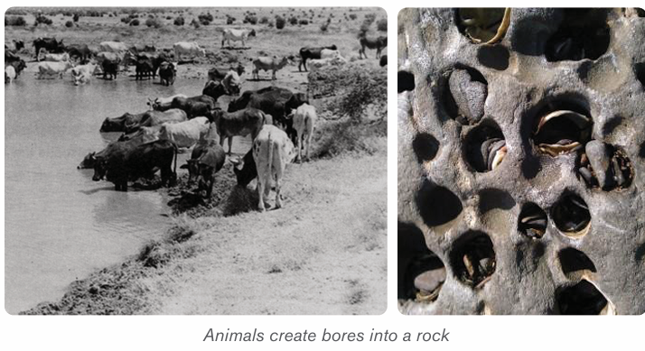
in such a fast rate of disintegration of rocks.
Application activity 3.1
Use your local environment to identify the evidences of biological weathering.
3.2. Factors influencing weathering and interdependence
of physical and chemical weathering
Learning activity 3.2
Using the diagram below, explain how these elements influence the rate ofweathering in your local area.
A number of factors are required for weathering to occur in any environment.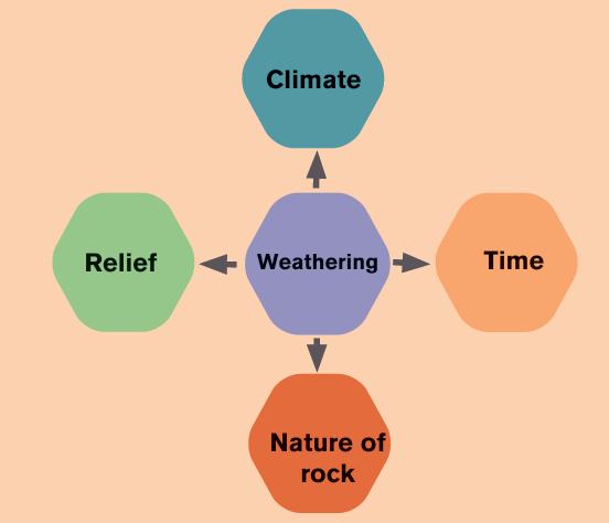
The major factors of weathering include relief, living organisms, time, climateand rock (parent material),
i) Relief
The term relief refers to the nature of landscape or topography. It influences
significantly the weathering process because it controls the flowing of run
off and infiltration of water through slope exposition, steepness and length. In
mountainous regions, the windward slopes receive heavy rainfall which may
speed up chemical weathering, whereas the leeward sides receiving little
amount of rain becoming arid. This favors physical weathering to dominate onthe leeward part.
ii) Living organisms
Living organisms include plants and animals. They both contribute to weathering
in a number of ways. Growing roots of trees widen and deepen into the ground
and open up joints. Animals ranging from the big to small, including man affect
the rate of weathering both mechanically and chemically. Animals and micro
organisms mix soils as they form burrows and pores, allowing moisture andgases to move about.
iii) Time
The longer a rock is exposed to agents of weathering, the more weathered it is
likely to be and vice-versa. Young rocks such as solidified volcanic rock after a
fresh volcanic eruption are likely to be less weathered than rocks formed long ago.
iv) Climate
The key components of climate in weathering are moisture and temperature.
The type and amount of precipitation influence soil formation by affecting the
movement of ions and particles through the soil, and aid in the development
of different soil profiles. High temperatures and heavy rainfall increase the rate
of chemical weathering. Arid and semi-arid areas are associated with physical
weathering since there is low rainfall and high temperature. As the rocks
expand during a period of high temperature and contract during a period of
low temperature, they develop cracks. In addition, equatorial regions with highrainfall and high temperature experience fast and deep chemical weathering.
v) Nature of rocks
Nature of the rock determines the rate at which it may break down. Their nature
depends on rock forming minerals. Some minerals are easily soluble. Also
environmental condition such as organic acids and temperature may increase
the rate of weathering of rocks. Soft rocks, for example, break down more easily
than hard rocks. Similarly, jointed rocks (rocks with cracks) break down faster
than rock substances without joints.
vi) The interdependence of physical and chemical weathering
There is interdependence between mechanical and chemical weathering.
Chemical weathering to occur needs first mechanical process which provides
fragmented pieces of rocks. These rock fragments are then attacked by the
chemical process of weathering. Many reasons can be advanced to justify their
interdependence:
• The joints and crack found in a rock as a result of physical weathering
allow deeper penetration of water which leads to chemical weathering.
• Some rocks are dissolved in water and weathered away in solution.
The solutions formed may later undergo precipitation leading to the
formation of crystal. These crystals will exert a lot of pressure that will
disintegrate the rocks physically.
• Hydration (chemical process) results in a high rate of absorbing water
by rocks .e.g.: hematite, limonite which makes these rocks to peel off in
a physical process called spheroidal weathering.
• The physical process of frost shattering opens up cracks in the rock
and when these cracks are occupied by water, chemical weathering
process takes place. e.g. carbonation.
• Roots of plants which expand within bedding planes of rocks and
burrowing animals which drill holes in rocks allow water entry into theserocks which accelerates chemical weathering.
Application activity 3.2
Visit your local environment and explain how relief and climate have influencedthe rate of weathering.
3.3. Landforms associated with weathering and their
importance
Learning activity 3.3
1. Identify the features associated to weathering
2. Analyse the importance of the following weathering features
a) Cave
b) Oasis
Landforms processes may be similar of different depending on whether rocks
have the same or different mineralogical compositions. The major landforms indifferent geological structures are briefly presented in the following paragraphs.
3.3.1. Landforms associated to weathering in limestone regions
Limestone is a sedimentary rock in which calcite (calcium carbonate: CaCO3 )
is the predominant mineral, and with varying minor amounts of other minerals
and clay. Limestone rocks are very sensitive to organic acids derived from the
decomposition of living organisms.
The major landforms associated with weathering in limestone regions are Karsts
landforms that include: caverns, stalagmites, stalactites, pillar, dolines, limestonepavements (uvalas), poljes.
1) Caverns
Caverns or caves are also one of the important characteristic features of
groundwater in limestone regions. Caverns are formed in several different
ways. The rocks in which most caverns occur are salt, gypsum, dolomite andlimestone, with the latter by far the most important.
2) Doline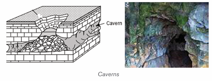
Doline also called Dolina is a round or elliptical hollow on the surface of a
limestone region which is formed when several small hollows merge. The small
hollows are formed when water starts acting on the points of convergence ofjoints on the surface.
3) Uvala
Uvala is a large surface depression (several km in diameter) in limestone terrain
(karst region). It is formed by the coalescence of adjoining dolines and has anirregular floor which is not as smooth as that of Polje.
4) Polje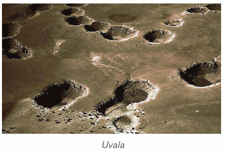
Polje is a large depression in a karst region with steep sides and flat floor. If it isdrained by surface water sources, it is termed as open Polje.
5) Stalactites
Stalactites are protrusions on top of limestone cave formed as results of waterdissolving some rocks which form a solution that leaks from the roof.
6) Stalagmites
Stalagmites are formed like a columnar concretion ascending from the floor
of a cave. It is formed from the re-precipitation of carbonate in calcite form
perpendicularly beneath a constant source of groundwater that drips off the
lower tip of a stalactite or percolates through the roof of a cave in a karstenvironment. It may eventually combine with a stalactite to form a pillar.
7) Pillars
Pillars are formed within the weathered limestone cave after the joining together
of stalactites from up and stalagmites from down. The two may finally meetforming a pillar.
For karst land forms to be formed the following conditions must be in place:
– Precipitation: the major types of precipitation which contribute to
groundwater are rainfall and snowfall.
– Slope: infiltration is greater on flat areas since water is likely to remain
in one place for a long time given that other factors are favorable. On
steep slopes, a lot of water is lost through surface run-off with little
infiltrating in the ground.
– Nature of the rock: For groundwater to percolate and accumulate
there must be spaces within the rocks for it to pass through as well as
to occupy further beneath.
– Vegetation cover: the presence of vegetation increases the rate of
infiltration.
– Level of saturation of the ground: The rate of water infiltration is
high when the ground is very dry and the soil is dry; all the air spacesin it are wide open.
3.3.2. Landforms associated with weathering in arid regions
The features formed in these regions as a result of weathering are both erosional and depositional.
a) Erosional features
1) Inselbergs
An inselberg (island hill or mountain in German) called Monadnock in the
United States, is an isolated hill, knob, ridge, or small mountain that rises
abruptly from a gently sloping or virtually level surrounding plain. These forms
are characterized by their separation from the surrounding terrain and frequentlyby their independence of the regional drainage network.
2) Bornhardts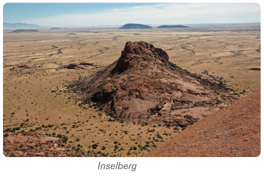
These are dome-shaped and steep-sided rocks that rise up to 30 meters. They
are massive rock, commonly granite comprised of bare rock that stretches
several hundred meters. They take many shapes such as oranges. A goodexample of where Bornhardts are found is Central Australia.
3) Tor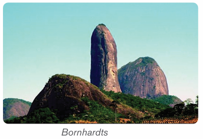
A tor is a pile like hill of rocks or rock peak. It is a product of massive weatheringand comes in all manner of shapes
4) Pediment
This is a rock that is gently inclined at an angle of 0.5 to 7 degrees. It is concave
in shape and is found at the base of hills where rainfall is heavy and falls over ashort period of time.
5) Deflation basins
Deflation is the process whereby loose or non-cohesive sediment are blown by
the wind. Depressions formed in the deserts due to removal of sand through the
process of deflation are called Deflation Basins. They are also called blow
outs or deserts hollows. The depth of deflation is determined by groundwatertable.
6) Mushroom rock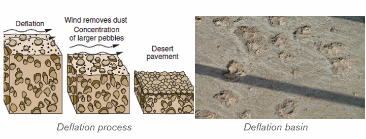
The rocks having broad upper part and narrow base resembling an umbrella
or mushroom are called mushroom rocks or pedestal rocks. These undercut,mushroom-shaped pedestal rocks are formed due to abrasive works of wind.
7) Demoiselles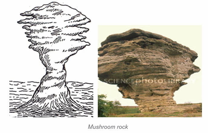
Demoiselles represent rock pillars having relatively resistant rocks at the top
and soft rocks below. These features are formed due to differential erosion of
hard rocks (less erosion) and soft rocks (more erosion). The demoiselles aremaintained so long as the resistant cap rocks are seated at the top of the pillars.
8) Zeugen
Rock masses of tabular form resembling a capped inkpot standing on softer
rock pedestal of shale, mudstone is called Zeugen. The bases of such featuresare broader than their tops.
9) Yardangs
These are formed always in the same way as Zeugens except that yardangs
only develop on landscapes which have alternating rock layers with different
resistance to erosion parallel to the direction of prevailing winds. Winds enter
and scour up rock particles from the soft bands, thus digging depressions within
the soft bands. The resistant hard bands therefore remain standing high up asraised ridges.
10) Reg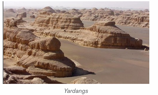
Reg is a desert surface covered with a pebble layer, resulting from long continued
deflation; found in the Sahara Desert of North Africa. Often the winds blow off
all the smaller fragments, and leave the bigger size pebbles and gravels over anextensive area.
11) Oases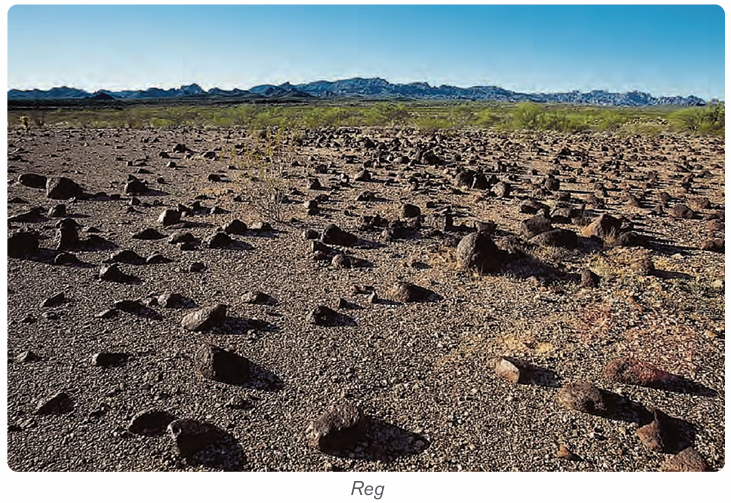
These are depressions that have water in deserts. These are created by strong
winds which remove rock particles from a particular place until a depression isexcavated (created).
b) Depositional features in desert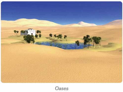
1) Dunes
Dunes are mounds or ridges of wind-blown sand. They are depositional features
of the sandy deserts and are generally mobile. They vary in size and structure.
The main types of sand dunes are Barchan, Transverse Dunes, and Seifs.
– Barkhans
Also called Barchans, these are typical crescent shaped sand dunes. The
windward slope of barchans is gentle and convex, and the leeward slope is
steep and concave. Barchans move slowly, at a rate of meters per year in thedirection of the prevailing winds.
– Seifs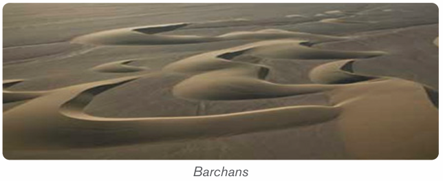
These are long and narrow sand ridge which grow parallel to the direction of theprevailing or dominant wind.
– Transverse dune
Transverse dune is an alongated dune lying at right angles to the prevailling
wind direction. They have a gentle sloping windward side and a steep slopingleeward side, they are commmon in areas with enough sand and poor vegetation.
2) Loess
Loess is a wind-blown deposit of fine silt and dust. It is unstratified, calcareous,permeable, homogenous and generally yellowish in colour.
3) Erg
Erg is also called sand sea or Dune Sea. It is a large, relatively flat area of desertcovered with wind-swept sand with little or no vegetative cover.
3.3.3. Importance of landforms resulting from weathering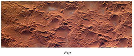
– This soil supports poor scrub vegetation as well as some shrubs and
grasses.
– Chalk landscapes are characterized by undulating topography.
– The surface and underground landforms of karsts appearance are
beautiful to attract tourists.
– Limestone blocks are used for building houses.
– They are also raw materials for cement manufacturing.
– Weathering results into soil formation.
– It produces a number of landforms which modify the nature of landscape
– It produces lateritic soils, which are important in road construction.
– It helps to expose mineral rock on the surface.– It produces clay which is important in pottery industry
Application activity 3.3
1. Examine the contribution of weathering on human activities2. Humid tropical regions are the most affected by weathering. Discuss
3.4. Mass wasting
3.4.1. Definition and types of mass wasting
Learning activity 3.4
Study the photograph below taken in northern part of Rwanda and describethe cause of the phenomena which happened.
i) Mass wasting
Mass wasting, also called mass movement, is defined as the creeping,
flowing, sliding or falling of rocks and weathered materials down slope under
gravity. It is different from erosion in a sense that, in erosion water physically
transports away the soil particles, in mass wasting water does not wash away
but assists the rock to slide down under the influence of gravity.
ii) Types of mass wasting
Mass wasting is classified into two major categories: Slow movement andrapid movement.
1) Slow movement
Also called creep movements, they are very slow in their motion and they may
occur without being noticed. These slow movements include:
• Soil creep: This is the most common and the most widely spread
type, because it is found in both tropical and temperate climates. The
movement of materials is so slow that they may move a few centimeters
per day. It can be detected by leaning of trees, electric poles andfencing poles in the direction of the slope.
• Solifluction: This is limited to glaciated mountainous regions and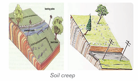
cold climatic areas where thawing causes the saturated surface layerto creep as a mass over underlying frozen ground.
• Talus creep: This is a down slope movement of mainly screes that are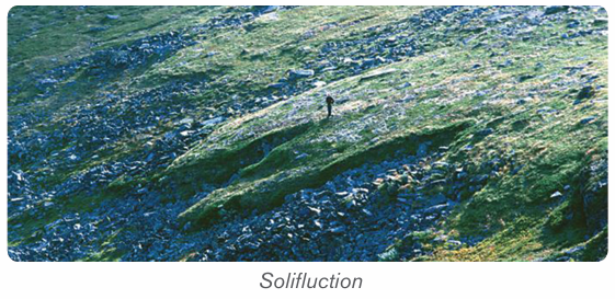
relatively dry. It occurs almost in the same way as soil creep and it also
occurs under tropical and temperate climate.
• Rock glacier creep: This is a slow process of slope failure in which
individual rock boulders with very little soil but with some ice embedded
within them slowly move down slope confined within a channel.
• Rock creep: This is the movement of individual rock boulders slowly
down slope
2) Rapid movement
• Earth flows: These are the rapid down ward movements of clayish or
silty soils along a steep slope.
• Mud flows: These are similar to earth flows but they are muddy and
occur on slopes that receive heavy rainfall. They are very fast. In Rwandathey are common in the Northern and Western-provinces.
• Debris avalanches: This is the most form of rapid flowage due to the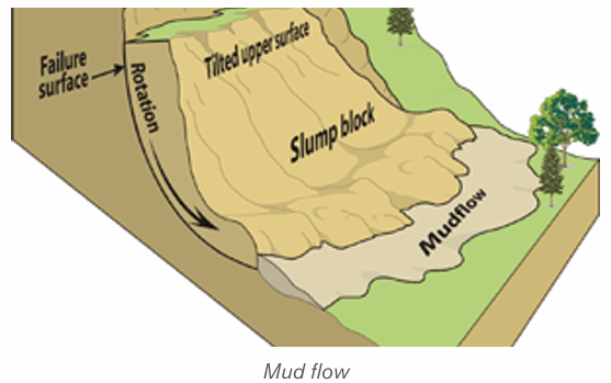
fact that slopes are very steep and there is enough rain to soak slopes.
It occurs on very steep slopes that occur in humid climate.
• Slumping: This is the downward slipping of one or several units of
rock debris, usually with a backward rotation with respect to the slope
over which movement takes place. Undercutting of slopes by streams
and man are the main causes of slumping. The surface of the slumped
mass has a number of step-like terraces.
• Rock slide: This is the type of sliding in which individual rock masses
fall from vertical cliffs or faces of slopes or jointed cliffs.• Rock fall: Here, individual boulders fall freely from a steep rock face.
Landslides: These are also called landslips. They are down-slope gravitational
movements of a body of rock or earth as a unit. It may be induced by natural
agencies (like heavy rain, earthquake) or it may be caused by human interferencewith the slope stability.
3.4.2. Causes of mass wasting
The following are the major causes of mass wasting:
– The degree of slope: The steeper the slope, the higher are the
chances of material movement. Mass wasting is almost nil in gentle and
flat areas.
– The structure and lithology of rocks: Alternating hard and soft rock
layers on a slope can be a cause of slope fall. For example, a layer of
clay on top of limestone layer can easily slide down.
– The degree of lubrication: Most mass wasting processes occur
after a heavy down pour. Water assists to lubricate rock particles and
the layers of rock on top of a slope. Therefore, water provides a medium
of sliding because it reduces internal friction between rock particles
and layers.
– The amount of load on a slope: Slopes which are light rarely fall
compared to those which are heavy. Therefore, additional load on a
slope increase chances of slope fall.
– Tectonic movements: Earthquake and Volcanic eruptions cause
vibrations of the earth which often trigger off widespread movements
of materials such as landslides.
– Climate: The amount and nature of rainfall received in an area
determines the kind of movement that occurs.
– Grazing: The grazing of cattle, movement of elephants and other
animals can cause some tremors on slopes hence making them fall.
– Nature of soil: soils which are infertile and therefore unable to support
vegetation in enough quantities, are more susceptible to mass wasting
compared to soils, which are fertile and therefore able to support dense
vegetation.
– Influence of vegetation: Vegetation help to hold rock materials
together thus reducing their movement on the surface.
– The work of animals: Animals and micro-organisms facilitate deep
weathering which results into the reduced cohesion of the rock particles
on slopes. This therefore leads to easy movement.
– Vulcanicity: Volcanic eruption on the ice capped highlands cause ice
to melt and therefore soak the slopes. This lubrication greatly increasesthe chances of slope movement.
Application activity 3.4
1. Examine the major causes of mass wasting2. Using diagrams distinguish between slumping to rock fall
3.5. Effects and control measures for mass wasting
Learning activity 3.5
Observe the photograph below showing the effects of mass wasting andanswer questions:
1. Analyse the effects of mass wasting.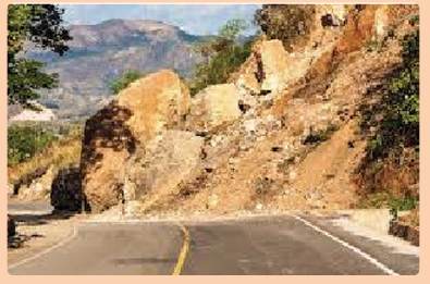
2. Suggest any three measures to control mass wasting.
3.5.1. Effects of mass wasting
The following are some of the effects of mass wasting:
– Threat to life and property: There are several serious incidents
of landslides and rock slides every year. They cause loss of life and
property. In a minor incident they may block only one line of a road, but
in severe cases entire blocks of buildings collapse.
– Loss of vegetation: Mass wasting and soil erosion result in the loss
of surface topsoil which is essential for vegetation. As a result, more
areas become barren.
– Scars and Gullies: In areas where topsoil and vegetation are removed,
bare spots form scars in the landscape. Gullies form on weathered
slopes through rain action and mass wasting in areas with little or no
vegetation. Intense gully cuts up the landscape into large-scale gullies
and ridges and destroys the area. Gullying is common in the bare,
granitic areas.
– Pollution of water: large amounts of geologic materials enter streams
as sediments as a result of this landslide and erosion activity, thus
reducing the potability of the water and quality of habitat for fish and
wildlife.
– Wildlife destruction: Although most kinds of wildlife are able to
retreat fast enough to avoid direct injury from all but the fastest-movinglandslides, often are subject to habitat damage by landslides.
3.5.2. Control measures for mass wasting
Mass wasting, especially landslides, has severe impacts on humans and
environments. For this reason, measures have to be taken for preventing or
mitigating them. Some of the measures are highlighted below:
– Gradients of steeper slopes could be reduced by constructing terraces.
– Retaining walls can be built to stabilize the slope.
– Steep slopes should be inspected regularly, especially during periods
of intense or prolonged rainfall to identify areas prone to mass wasting
for preventive measures.
– More surface drainage channels and ditches can be constructed to
reduce overflowing discharge
– Legislation can restrict development and building in zones prone to
mass wasting.
– Trees can be planted on steeper slopes to stabilize the soil and the slope.
– Appropriate instruments can be installed to monitor slope stability,
providing early warning in areas of concern.– Mass education of people
Application activity 3.5
Make a field trip to observe different areas affected by mass wasting.
Analyse the causes of mass wasting and propose the sustainable measuresto control it.
Skills Lab
Identify any area mostly affected by mass wasting, examine how theCommunity Work / Umuganda may help you to fight against it.
End unit assessment
1. Give the reasons why highlands are the most affected by mass wasting.
2. How have topography and parent rock influenced the rate of
weathering in your area?
3. Explain how the weathering landforms identified in your area affectpositively and negatively human activities.