General
- Geography S2 SB File Uploaded 24/01/22, 16:02
- S2: Geography TG File Uploaded 11/08/22, 21:52
Unit 9: CLIMATE AND CLIMATE CHANGE IN RWANDA
Key unit competence
At the end of this unit, you should be able to analyse the climate of Rwanda and how climate change has impacted on it. Compare and contrast the impacts on Rwanda with other countries.Introduction
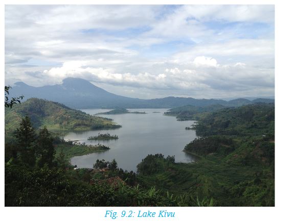
The Republic of Rwanda, also known as “the Land of a Thousand Hills”, boasts of moderate temperatures and ample rainfall throughout the year. A notable difference in the prevailing climatic condition is also attributed to the presence of Lake Kivu on the western part of the country. For instance, it’s rainy in the northern and western parts of the country, more being received in the forested areas. The eastern parts tend to be drier than any other part of the country. The country experiences moderate daytime temperatures in the lower mountains, much cooler temperatures on the higher mountains, with nighttime temperatures being moderate.Climate influences the various human activities people engage in. For instance, the drier areas in the eastern and south eastern regions such as Nyagatare, Ngoma, Kirehe, Busegera and Mayaga favour pastoralism while the wetter areas in the northern and western parts such as Musanze, Rubavu, Nyamagabe and Gicumbi are good for crop farming. The forested areas such as Nyungwe on the other hand promote tourism.9.1 Climatic regions and seasons in Rwanda
Activity 9.1
In groups of five:
1. Discuss the differentiate between weather and climate.
2. Identify six elements of weather and give the name of instruments used to measure each of them.
Climate is the average weather conditions of an area recorded over a long period of time. This period may range between 30 and 35 years.
Activity 9.2
Use your dictionary, the Internet and other geographical documents to differentiate between the terms ‘climate’ and ‘seasons’. Write your findings in your notebook. Share your findings with your classmate.
9.1.1 Major climatic regions of Rwanda
The climatic regions in Rwanda can generally be categorised as follows:
a) Tropical wet Lake Kivu
b) Tropical wet-dry central plateau
c) Tropical wet-dry lowlands
d) Temperate tropical highland
Activity 9.3
Look at the map of Rwanda shown below. It shows the two various climatic regions in our country.
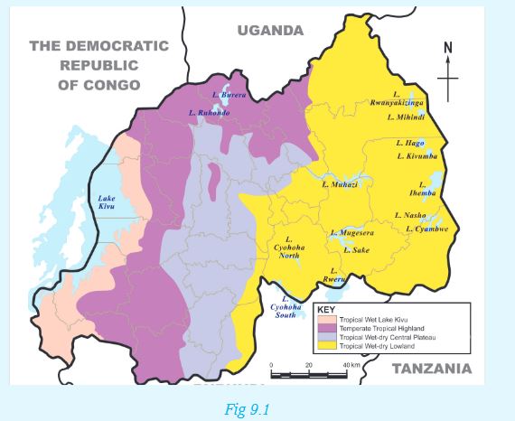
1. In groups of five, use an atlas showing administrative regions to identify the provinces where each climatic region is found. Share your findings with the class.
2. From the map above, which type of climate is experienced in your local area?
Tropical wet Lake Kivu
In this region, average annual rainfall levels range between 1300 mm (Lake Kivu) to 2000 mm (Nyungwe and Volcanoes). Rainfall is received all year round, though you will find the area wrongly referred to as experiencing a double rainy season. This is because it has two rainfall seasons where the average received is higher than all the other months.
Temperatures depend on altitude and levels of humidity, with Lake Kivu experiencing an average of 250C, Nyungwe cooler at 15.50C and Volcanoes being colder at 9.50C. However, rainforest temperature, for example in the Nyungwe forest, can rise to up to 300C. Moving east, the altitude drops, and the climate is much more clearly dry-wet tropical (semi-arid). Temperatures range between 240C and 280C and average rainfall levels fall to between 750mm (Akagera National Park) and 1000mm (Kigali).
Tropical wet-dry central plateau
Areas within the high altitude of between 1500m and 2000m above sea level especially in the central plateau, accounts for its tropical highland climate. Daily temperatures typically range as much as 250C. The sun shines nearly all year round, and, whatever the season, the mean daily temperature is close to 24°C. Most of the country has minimum night temperatures of around 10°C and maximum daytime temperatures of around 300C.
The central plateau has moderate rain. Rainfall is between 1000 mm and 1200 mm. Areas in Rwanda that experience this type of climatic conditions include Huye, Muhanga and Rubona.
Tropical wet-dry lowlands
In this region, climate is very hot and fairly dry. The average annual temperature is between 200C and 220C. Some areas, for example those near Gabiro, which are at an altitude of about 1480m above sea level experience a temperature of about 210C.
The sky is less cloudy and the area receives little rainfall, sometimes going as low as 1000 mm per year. Areas such as Gabiro and Karama receive approximately 830 mm and 850mm of rainfall per year respectively.
Temperate tropical highland
Areas that receive this type of rainfall are mainly found in the western and northern highland region (the Congo-Nile peak and Birunga region). They lie generally between 1800 m and 3000 m above sea level.
These areas are generally humid with the annual temperatures becoming cooler as the altitude increases. Temperatures experienced range between 150C and 170C. Climatic conditions of these characterstics are experienced in areas such as Musanze, which lies at 1860 m above sea level and Gisovu, at 2300m above sea level. The two areas experience an average of 18oC and 15oC respectively.
Rainfall is abundant and always above 1200 m. For example, Musanze, at 1860 m of altitude receive about 1300 mm of rainfall while Mata (Nyaruguru), at 1900 m of altitude receive 1575 mm of rainfall.
9.1.2 Types of seasons in Rwanda
There are two major seasons in Rwanda. These are the rainy season and the dry season.The long dry season starts from June to mid-September. From mid September to mid December is a short rainy season. This season is followed by a short dry season from mid December to mid February. However, there is a long rainy season between mid February and May.
Remember!
In Rwanda, seasons are broadly classified as dry or rainy. These seasons do not follow a certain trend (that is Winter, Spring, Summer and Autumn), as is the case with seasons in countries found in high latitudes such as America.
Activity 9.4
1. List in your notebooks the specific periods in terms of months of the year when Rwanda generally experiences a dry season and a wet season. Which months are seen as transitional months between one season to the other?
2. Identify and explain the various human activities that take place during the various seasons experienced in Rwanda. For example, before the rainy season, farmers usually prepare their farms for the next planting season.
9.2 The concept of climate change
Climate change is a large-scale, long-term shift in the weather patterns. For instance, the average temperatures over a large area of land may generally increase. Evidence of climate change may be in terms of:
i) Temperature changes
ii) Changing rainfall patterns
iii) Changes in seasons
Activity 9.5
In groups, use geographical documents, textbooks and the internet to research and discuss about the concept of climate change in Rwanda. Write down the findings for class presentation.
Remember!
The Government of Rwanda, through the Green Growth and Climate Resilience Strategy, aims to deal directly with actions that directly lead to climate change. This is through actions such as:
• Reducing dependence on rain-fed agriculture.
• Seeking cheaper, better alternative sources of electricity.
• Reducing emissions into the atmosphere that pollute the environment.
• Protecting the environment against further destruction through various human activities.
9.3 Causes of climate change in Rwanda
a) Pollution
This is the contamination of air, soil, water and the environment in general. In other words, pollution is anything that makes the earth dirty and unhealthy.
Activity 9.6
1. In your notebooks, make notes on the four main types of pollution.
2. Research from the Internet and other geographical sources the concept of global warming. Use diagrams where possible.
Air pollution is the most rampant type of pollution in Rwanda. The main air pollutant is carbon dioxide, which is emitted from industries and motor vehicles exhaust fumes.
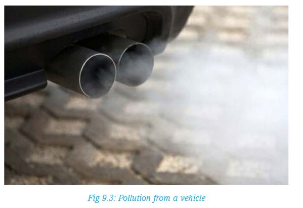
Air pollutants cause global warming by trapping heat from the sun in the earth’s atmosphere, causing a rise in temperature on the earth’s surface.
b) Human misuse of the environment
There are many types of human activities that directly cause changes in climate.
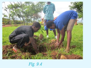
Activity 9.7
1.Look at the photograph below. Identify the activity taking place. Explain how such activities may contribute to climate change. Cite examples from the local environment.
2.Explain how the following human activities contribute to climate change. In each case, state whether it promotes or destroys the environment.
• Deforestation
• Construction of dams or reservoirs
• Overstocking
• Growing crops such as rice under irrigation
Remember!
Human activities can alter the climate of a region either positively or negatively. In order to maintain a perfect balance in our environment, we should engage in activities that better our environment.
9.4 Effects of climate change in Rwanda
Changes in weather patterns over time have had a major effect on various human activities in Rwanda. These include farming, fishing, settlement, transport and even time to go for holidays.The following are some of the resultant effects of climate change in Rwanda:
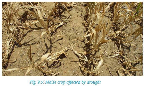
a) Drought
b) Landslides
c) Floods
d) Aridity and desertification
Each of these effects is discussed below:
a) Drought
Drought is a long period of dry weather, when no rain falls for weeks or even months.
Activity 9.8
1.In groups, explain how the following factors have contributed to drought in Rwanda in the recent past:
i) Low rainfall totals
ii) Deforestation
iii) Overgrazing of animals
iv) Poor methods of farming like bush burning and monocropping
2.Describe how the factors above affected the livelihood of people, animals and the environment at large.
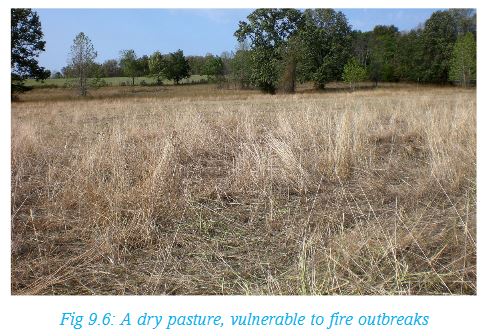
Drought has many effects, including the following:
• A shortage in the supply of water both for domestic and industrial use.
• Loss of livestock to starvation due to lack of pasture.
• Reduced hydro-electric power generation due to reduced water levels in rivers.
• Reduced food production as a result of less rain and little water in the rivers to support crop cultivation.
• Drying up of pasture lands, making them vulnerable to fire outbreaks.
• Reduced recreation and tourism activities, especially when wild animals migrate in search for pasture and water.
b) Landslides
A landslide occurs when a large mass of earth, rock or other material move down a slope. The process may be slow, taking place over a long period of time, or rapid. In most cases, rapid landslides can be destructive to life and property.
Due to climate change, there are cases of extremely heavy rains received in some parts of our country. This has caused a lot of destruction, such as landslides. Landslides occur when there is persistent rainfall in highland areas with inadequate cover. Oversaturation of the topsoil with water causes it to move downslope, sometimes abruptly.
For instance, on 3rd April 2015, heavy rainfall caused flooding and landslides in Nyamasheke and Rubavu districts in Western Province.In some cases, heavy rains on the sandy soils on the hills has resulted into landslides, leading to blocking of roads. For example, Mugoroba road was once blocked by a landslide, making it impossible for vehicles and pedestrians to pass.
Property, roads and people in Nyabihu District have also been victims of landslides in the recent past. There is destruction of property, loss of human and animal lives and destruction of homes as well infrastructure. Landslides also cause a destruction of the agricultural land in low lands and on hill slopes.
When soil is massively deposited into river channels after a landslide, it may cause flooding and overflow of water, leading to further destruction from floods.
Activity 9.9
1. In pairs, discuss the occurrence of landslides in Rwanda.
2. Explain the effects of landslides to: people, plants, animals, property, infrastructure, and river channels.
3. Which measures can be put in place to reduce the occurrence and effects of the landslides?
c) Floods
Floods occur when land is totally covered by water. It can be caused by an overflow from existing water channels. It can also be caused by persistent rainfall over a period of time, leading to overflowing due to oversaturation of the soil.
Changing weather patterns are also responsible for recurrent floods in Rwanda. This is also caused by more than usual rains.
Activity 9.10
Read the following story then answer the question that follows:
It rained heavily in Kicukiro yesterday evening. Mutoni got so worried that she thought their house could be swept away by floods. When she asked her father if this could happen, he replied:
“I once read from the website of reliefweb that in June 2012, there were floods in Musanze in Northern Province, and Nyabihu and Rubavu districts in Western Province. Many people were displaced, water supplies got affected and roads, schools, clinics and over 700 homes damaged. Crops in the farms were not spared either. In April 2015, heavy rainfall caused flooding and landslides in Nyamasheke and Rubavu Districts in Rwanda’s Western Province. As he concluded, he said,
“The rains experienced back then were four times more that what we are experiencing now. There is no need to worry,” he said.
In pairs, discuss the effects of floods using the story above. Generate a list of what you have discussed in your notebooks.
d) Aridity and desertification
Activity 9.11
1. Use the dictionary to differentiate between ‘aridity’ and ‘desertification’.
Explain how the two terms are related.
2. Mention any four deserts that you know.
3. Find out some human activities that lead to aridity and desertification.
4. Research from the Internet and from other geographical documents the effects of aridity and desertification in Rwanda.
Make a class presentation of your findings.
The government’s efforts to tackle desertification are clearly visible. Gishwati Forest for instance has undergone massive reforestation after it was almost cleared for human settlement and agriculture.
9.5 Climate change adaptation and mitigation in Rwanda
Activity 9.12
1. Using your dictionary, explain the meaning of adaptation and mitigation.
2. With the guidance of your teacher, take a trip around your school. Identify ways in which residents and the government have put in place to mitigate:
i. Droughts
ii. Landslides
iii. Floods
iv. Aridity and desertification
Write down your findings for a class presentation.
The following are some of the ways to lessen the effects of climate change in Rwanda:
a) Drought
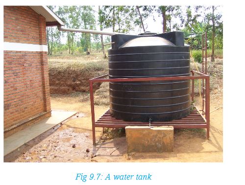
• Efficient use of water when in plenty.
• Growing drought resistant crops such as cassavas, yams, bananas, millet and sorghum.
• Recycling water from industries and homes to ensure maximum usage of available water.
• Irrigating farms with available water to increase crop productivity.
• Storing excess water during the rainy season.
b) Landslides
• Afforestation on steep slopes prone to landslides.
• Application of improved farming methods on steep slopes by terracing and contour ploughing.
• Restricting settlement and infrastructural development on hill slopes.
• Building barrier walls on slopes that often experience landslides.
• Growing cover crops to slow the movement of water and increase saturation. Such crops also hold the soil particles together firmly.
c) Floods
• Improving drainage through construction of pumping stations, water gates, culverts and water tunnels.
• Keeping drainage channels clear to enable water to flow within the confines of the channels. This includes unblocking them when congested with silt and garbage.
• Construction of check dams to store excess water during the rainy season. This can also include extending areas that serve as retention basins to increase their capacity to hold more water.
• Limiting construction of permanent structures near or across water courses.•Avoiding disposal of wastes in water channels.
• Discouraging deforestation that increases surface runoff, causing siltation and subsequent flooding.
d) Aridity and desertification
Efforts to combat aridity and desertification in Rwanda include:
1. Advocating for a reduction of livestock numbers to reduce chances of overgrazing.
2. Improving in farming methods to avoid the effects of monoculture and other methods of farming.
3. Sensitising the public on the need for smaller families in order to reduce the need for more housing.
4. Carrying out tree planting campaigns to increase the forest cover and restore forests that were once cleared.
5. Subsidising alternative sources of energy to substitute the use of charcoal and firewood.
6. Educating the public on the causes and effects of aridity and desertification, and possible ways of how to curb the same.
END OF UNIT REVISION QUESTIONS
1. In your note books, draw the map of Rwanda showing the climatic zones of Rwanda.
2. Write down the indicators for climate change in Rwanda.
3. Explain the causes and effects of climate change in Rwanda.
4. Write an essay on the measures being taken in Rwanda to mitigate effects of climate change.