Topic outline
Unit 1: MAP WORK INTERPRETATION
Key unit competency
At the end of this unit, you should be able to demonstrate how to measure distance and area on a map.Introduction
Activity 1.1
Draw a sketch map of your school compound on a squared piece of paper.
a)List the main things that you will include on your sketch.
b)Explain how you will represent major features such as classrooms, the staffroom, playing ground, toilets and the gate on your sketch.Include all the elements of a good map on your sketch, that is, the key, scale, frame, title and compass direction.
The activity above shows that you can use a map of your school to:
• Show the location of major features on the ground.
• Give direction and bearing from one point to another.
• Estimate the distance between one place to another.
Using the sketch you have drawn, show your classmate how a person can move from the gate to the staff room, from your class to the playing ground and from the car park to the toilets.
You will realise that you can also help a person to tell the direction from one point to another as well as bearing.
We are now going to discuss the following sections with the aid of a map:
• Location of places and features on maps
• Direction and bearing
• Use of grid references
• Measuring distances and areas on a map
• Description of relief on a map
1.1 Location of places and features on maps
It is also possible to tell the location of places and features on a map, the same way it is possible to do so using the sketch map you drew in Activity 1.1.
In Senior One, you learnt about the good qualities of a map. You mention five elements, one of them being a compass point. What were the other elements of a map?
Activity 1.2
In pairs, study carefully the following map then answer the questions that follow: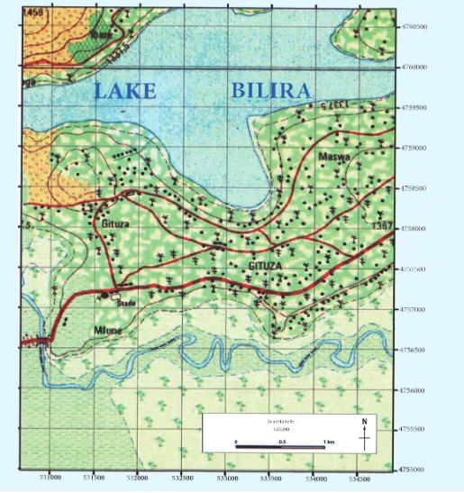
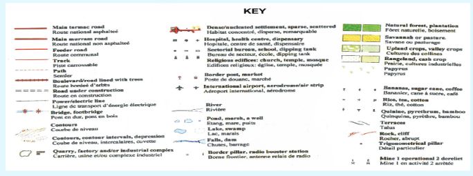
1.Using the key provided, identify the main features shown on the map.
2.If you were near Maswa, how would you describe the location of the Stade near Mfune.
3.Redraw the compass given on the map to have eight points. Use your new compass for this activity.If the bridge on the river is described as being on the south western part of the map, give a description to show the position of the plantation at Ibare.
4.From Lake Bilira on the northern part of the map, give the direction of the Papyrus swamp.
The activity above details how to give direction on a map using a compass. The compass points you have drawn above can further be divided into sixteen points as shown below.
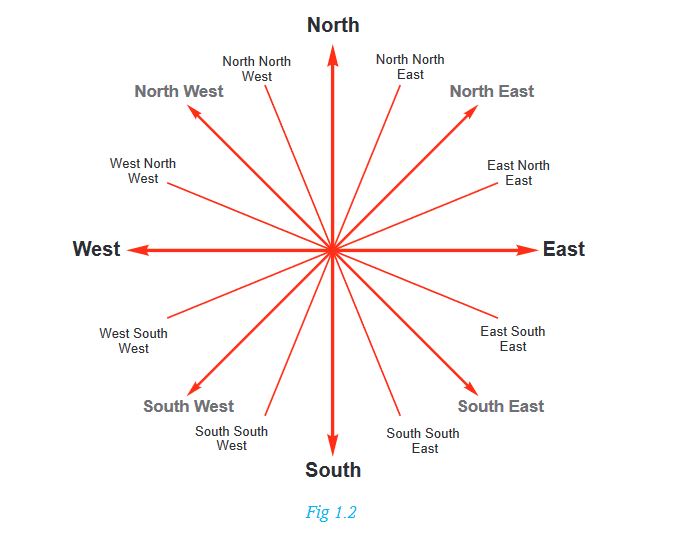
1.2 Direction and bearing
On a map, direction is the description of a place in relation to another known point by use of a compass.
a) How to find direction on a map
To find direction on a map, follow these steps:
-Identify the two points in question.
-Draw a line joining the two points.
-Draw a compass with the four cardinal points on the point where you are told ‘from’.
-Draw a horizontal line on that point showing east and west direction.
-Use the compass drawn to determine direction.
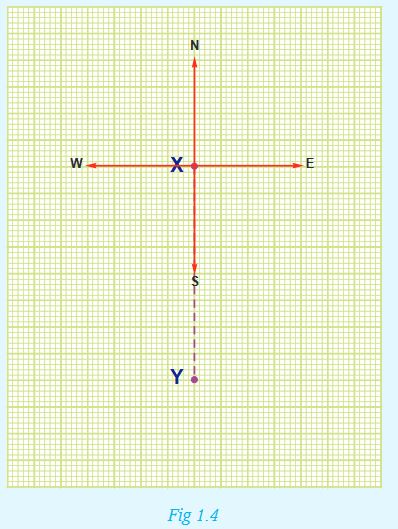
Activity 1.3
1. Use the following steps to identify the direction of Y from X as shown in the diagram below.
Steps
i) Draw a compass with four cardinal points through point X. Label the lines with compass directions, that is, North (N), South (S), East (E) and West (W).
ii) Draw lines joining X and Y.
iii) Starting from North, move clockwise until you reach the line joining X and Y.
iv) You will realise that Y is to the South of X.
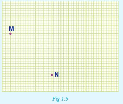
2. Use the steps detailed above to give the direction of point M from point N on the diagram below.
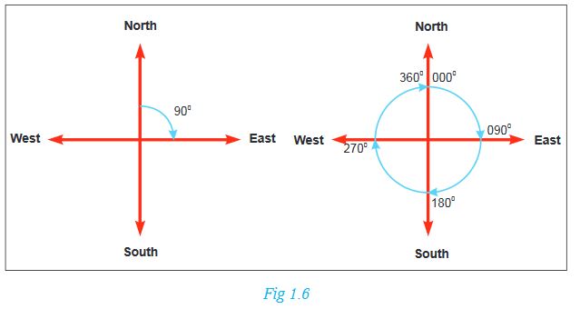
Bearing
Bearing is the direction measured as an angle and given in degrees. Bearing is read in a clockwise direction from the north line as shown below.
Activity 1.4
1.Use the following steps to determine the bearing of point A from B shown in the figure below.
- Identify the two points, in this case given as A and B.
- Mark the two places with a pencil.
- Join the two places with a straight line.
- At the point where the bearing is required, draw a line running through the point from north to south.
- Place a protractor on the point where bearing is required. Read the angle in a clockwise direction from the North line.
- Read the angle where the protractor touches the drawn line that connected two points. This angle should be stated in three digits. Say if it is 45º, write 045º
2.The following diagram shows the bearing of point C from D. Using a protractor, measure the angle indicated by the red line and give the correct bearing of point C from D.
Points to note
- All places to the East of the North-South line have bearings of between 0º to 180º. Those to the West of the same line have bearings of between 180º to 360º.
- The North has a bearing of 360º or 0º.
- Bearing is stated in three figures, such as 000º , 075º or 250º.
Activity 1.5
Study the diagram below then answer the questions that follow:
1.Determine the direction of point Z from X.
2.Use the following steps to determine the bearing of point X from Z.
• Draw a line to join points X and Z.
• Draw a compass at point Z.
• Measure using a protractor the angle between the North and line XZ.
• Measure clockwise from North, up to line XZ.
1.3 Use of grid references
Grid reference method involves the use of grid lines. Grid lines are the vertical and horizontal lines which are printed on topographical maps.
Activity 1.6
Create your own graph with gridlines
Get a graph paper, on it draw a rectangle that is 18 cm long and 14 cm inside. Use an interval of 2 cm to draw vertical lines using a red pen and horizontal lines using a blue pen.The resultant drawing will look like a mesh wire with square boxes. These are called grid squares. Keep the graph paper for the next activity.
The lines you drew above are similar to those that make a system of small squares on survey maps. However, these grid lines should not be mistaken with the latitudes and longitudes.
The vertical lines you drew using the red marker pen, when shown on a survey map, represent Eastings. They are called Eastings because they are usually numbered eastwards.
The horizontal lines you drew using the blue marker pen, when shown on a survey map, represent Northings. They are called Northings because they are usually numbered northwards.
Giving the four figure grid reference
Activity 1.7
Use the following procedure to determine the location of point A.
Read and give the figure for the Eastings (vertical grid line) then follow this with the Northings (horizontal grid line). From the grid given below, point A will be recorded as follows: Eastings: 44; Northings: 36. The four figure grid reference is 4436.

1.Using the grid squares above, state the four figure grid reference of points B to F.
2.On the graph paper you drew the grid, mark at random points X where two grid lines intersect.Give the four figure grid reference of point X you have marked on your grid.
Note: All points within a square have the same four figure grid reference.
Giving the six figure grid reference
Activity 1.8
Use the following procedure to give the six figure grid reference of point N from the grid given below.
- Write down the easting, which in this case is 52.
- Subdivide the easting between 52 and 53 into ten equal parts.
- Write the value of N from the easting out of the ten subdivisions, which is 7.This figure forms the third digit for the easting.The easting for this point therefore is 527.
- Write down the Northing which is 34.
- Subdivide the distance between northing 34 and 35 into ten equal parts.
- Write down the value of the northing out of the ten subdivisions, which is 7. This figure forms the third digit for the northing.The northing for this point therefore is 347.•The six figure grid reference for point N therefore will be 527347.
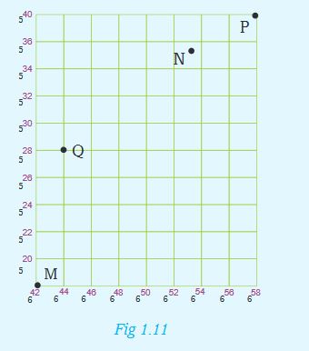
1.Using the grid squares above,state the four figure grid reference of points M,Q and P.
2.On the graph you drew on the graph paper, mark all the Eastings and Northings with two-digit numbers. Within the graph, mark at random points J and K.Give the six figure grid reference of the points you have marked on your grid.
1.4 Measuring distances and areas on a map
To measure distance and calculate area on a map, we use a scale and grid boxes.
Activity 1.9
From the knowledge gained in Senior One when studying elements of a good map:1. Define a scale.2. Identify the types of scales used on maps.In order to understand this section well,let us first handle the measurement of distances. Since maps are usually representations of a bigger area on a small piece of paper, then to know the distance between two places on the actual ground is indeed crucial.What should be noted here is that there are distances of straight lines and those of curved lines.Measuring distance of straight lines
The features with straight edges include runways, sections of some roads, football grounds, rectangular water dams and others. Distances of such features can be measured using:
• A pair of dividers
• A straight edge of a piece of paper
• A ruler
a) How to use a pair of dividers
Mark the starting and end points on the distance asked to be measured on the map.
Join the two points with a straight line using a ruler and a pencil. Open your pair of dividers to a convenient unit on the scale as shown below.
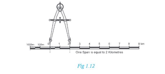
Rotate the pair of dividers along the line. Make sure you count the number of rotations.
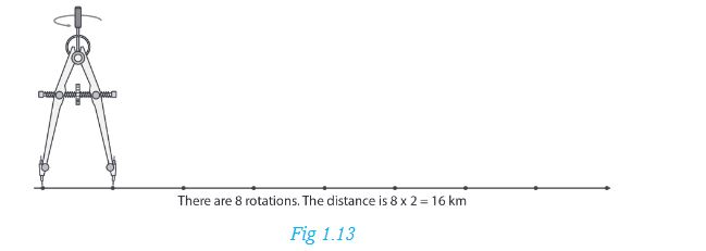
Multiply the number of rotations with the distance of the span.
b) How to use a straight edge of a paper
• Mark and join the starting and end points on the map using a pencil and a ruler.
• Place the straight edge of a paper along the required distance of a straight line.
• Mark on the paper the start and end points of the required distance.
• Transfer your marked paper to the linear scale and read off the distance as it appears on the actual ground.
c) How to use a ruler
• Mark both starting and end points on the map.
• Draw a line joining the two points using a pencil and a ruler.
• Use the centimetre side to read the measurement.
• Use the scale to obtain the actual distance on the ground.
Activity 1.10
Measure the distance of the murram road from the tarmac road to the church on the map given on page 4:
1. Using a straight edge of a paper.
2. Using a ruler.Use the scale: 1 centimetre represents one kilometre.
3. Compare your answers with that of your classmate. Discuss how you arrived at your answers.
Measuring distance of curved lines
Some of the features on the earth’s surface are irregular and curvy. With curving features, sections of such a feature have to be measured in patches. Thereafter, the lengths are added together and the overall distance is obtained.
To measure their distances, we can use:
a) a non-elastic cotton thread.
b) a straight edge of paper.
a) How to use a cotton thread
This is a method that is used to measure curved distances on a map such as roads, rivers or railway lines. Steps to be followed:
1.Identify and label the two points of the feature that will be measured, for example, A and B.
2.Tie a knot at the end of the string then place it at point A then align the string along the curved line up to point B.
3.Mark the end point then transfer it to the linear scale and read the distance on the linear scale.
Remember to express the results in ground distance such as kilometres or metres.

b) How to use a straight edge of a paper
This is another method of measuring curved distances.Identify and mark the two points of the feature that will be measured, for example, X and Y.
Take a strip of paper with a straight edge and mark X along the edge of the paper.Align the strip of paper along the distance you want to measure as shown below.
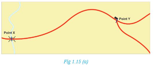


Move the paper carefully along the river, road or railway line, marking off the straight edges up to point Y. Take the marked paper and place it on the linear scale. Point X should be placed at 0 km. Read the distance as shown in Fig 1.15(e).
Activity 1.11
Measure the distance of the road between grid reference 764790 and 790850.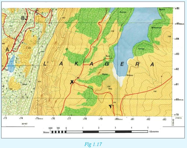
Measuring areas on a map
Areas with regular shapes
The areas on a map with regular shapes are calculated using mathematical formulae.
Activity 1.12
Write down the mathematical formulae used to calculate the area of:•A square •A rectangle •A triangle•A trapezium •A circleAreas with irregular shapes
Most natural features such as lakes and forests have irregular shapes. To calculate their areas, we use the grid square method.
The following steps should be followed:
Divide the map into equal squares with the help of eastings and northings. Each square will represent 1 km2(one square kilometre).
Mark out and count the complete squares covered by the irregular surfaces.
Mark out and count the squares which are not fully covered. Take the total number of the incomplete squares and divide them by two.
Add the number of the complete squares to the answer you got after dividing the total number of the incomplete squares with two.The figure you get is the area of the irregular surface. Give your answer in km2.
Activity 1.13
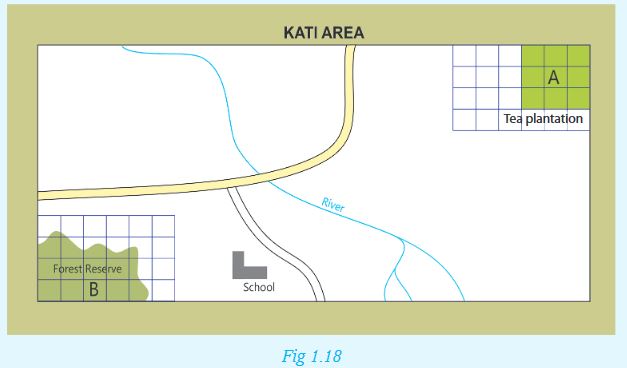
Calculate the area covered by the forest reserve on the sketch map of Kati Area.
1.5 Description of relief on a map
Relief refers to the general physical appearance of the landscape. It includes all the physical features found on the earth’s surface. Therefore, a map shows a number of selected physical and human features and their exact positions on the earth’s surface.
The relief features that can be shown on a map include:
•Hills •Mountains •Plains
•Valleys •Plateaus
The various relief features that can be shown on a map are usually represented by use of:
a) Colours c) Trigonometric stations
b) Contours d) Spot heights
Each of these is as explained below.
i) Use of colours
Relief can be represented on a map by use of colour. The following are features and colours used to represent them.
• Mountains–Purple
• Hills and uplands–Brown
• Mountaintops-White
ii) Use of contours
Contours are lines drawn on a map to join areas with the same height above sea level. They show height and shape of relief features such as hills, valleys, slopes and ridges. Contour lines that are drawn close together depict a steep slope while those that are widely spaced depict plateaus and plains. Contours are measured in metres. Differences in height between two successive contours is referred to as vertical interval or contour interval.
iii) Trigonometric stations
A trigonometric station is a point represented on a map by a triangle or circle with a dot at the centre. In some cases, trigonometric stations on maps are represented as triangular drawings with the height above the sea level indicated below them. Trigonometric stations on maps usually appear in areas that are highlands. These places include mountains, hills and mountain ranges.
A trigonometric station usually indicates a fixed surveying station used in surveying.
iv) Spot heights
A spot height is an exact altitude of a point on a map. The height of the area is recorded next the spot height.
Activity 1.14
1. Relief is the general physical appearance of the landscape. Identify and explain:
a) Some of the relief features that can be shown on a topographical map.
b) How colour can be used to show relief on topographical maps.
2. Using the following map extracts, give the height above sea level basing on the following indicators of relief:
• Trigonometric stations
• Spot heights
• Contour lines
Map of Rutonde (Part of Rwamagana Survey map)

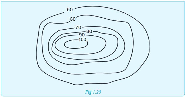
1. Contour interval is the difference in height between two successive contours. Study the following illustration showing arrangement of contours on a certain landscape and calculate its contour interval.
END OF UNIT REVISION EXERCISE
1.(a) Explain the procedure followed while finding the bearing of one point from another.
(b) Using the procedure you have given in question (a) above,find the bearing of point F from G in the diagram below.

2.Briefly write notes on the meaning of grid references.
3.Define the following terms:
a) Relief
b) Contours
c) Contour interval
d) Trigonometric station
4.Find out how important a spot height is to a map reader. Make short notes from your findings
File: 1URLs: 2Unit 2: TYPES OF PHOTOGRAPHS
Key unit competence
At the end of this unit, you should be able to interpret different types of photographsIntroduction
Ingabire, is a Senior Two student in Nyagatare School. She held her birthday party last year. She asked her friend, Mugabo, to take photographs during the party. After the party, she went to the nearby recreational park where they took many photographs with her friends. Today, the park is different because many trees and flowers have been planted in it. It is more beautiful than it was before.
Seven months later, Ingabire still remembers her birthday party as if it was held yesterday. She is fond of showing her friends the photographs when narrating how her party was.
From the story above, you will realise that photographs are very important. This is because they can be used to record and keep information. This information is usually about various things that happen around us. They can also show how the environment around us has been changing over time.In Senior One, we learnt about the differences between maps and aerial photographs. In this unit, we will learn more about photographs by studying Definition of photographs, Types and parts of photographs and Importance of photographs.
2.1 Definition of photographs
Activity 2.1
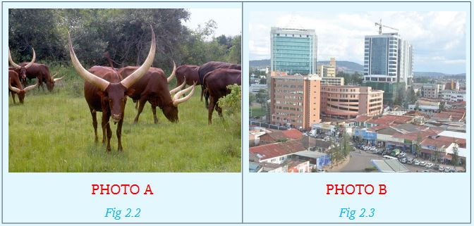
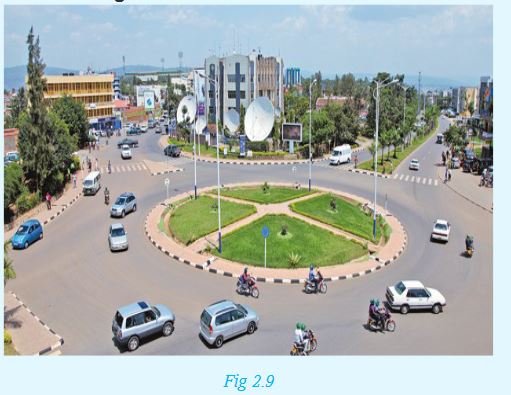
Study the following photograph carefully.
In pairs:
a) List down all the things you can see.
b) State the activity taking place in the photograph.
c) Estimate the time of the day when the photograph was taken.
From Activity 2.1, you will realise that the photograph above has images of people and objects. The photograph also shows in great detail other features in the area.
A photograph is an image of an object or person taken with a camera and printed on a special paper.
2.2 Types and parts of photographs
1. Types of photographs
Activity 2.2
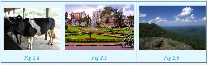
Study the following photographs carefully.
a)Identify the main images each photograph is showing.
b)List all the other things the photographs are showing other than the main images.
c)With a reason, state the position where the person who took each of the photo was.
d)Suggest where these photographs might have been taken in Rwanda.
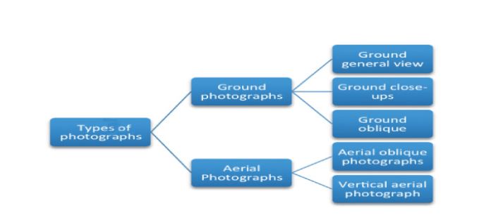
Photographs can be categorised according to the viewpoint, that is, the point from which they were taken. From this, the following types of photographs can be identified:
•Those taken while on the ground
•Those taken from above the ground
There are two types of photographs. These are classified on the basis of the position and location of the camera at the time the photograph was taken.
The two types of photographs are:
a) Ground photographs
b) Aerial photographs
Activity 2.3
Classify Photo A and B shown in Activity 2.2 as either a ground photograph or an aerial photograph.
a) Ground photographs
Ground photographs are further divided into three:
(i) Ground general view
(ii) Ground close-ups
(iii) Ground oblique
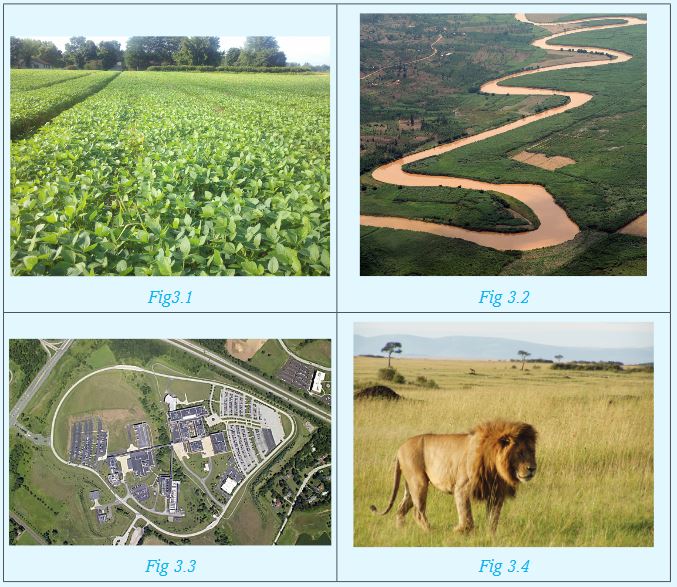
Activity 2.4
The following photographs show the three types of ground photographs:
Read the definition of each the three types of ground photographs then classify the above photographs accordingly:
(i) Ground general view: These types of photographs are produced when the camera is held horizontally to the ground facing the area or landscape focused on. Objects in such photographs become smaller the further they are from the camera.
(ii) Ground close-ups: In such photographs, the camera is focused on one major object such as a person, an animal or a house. The object may block out the other things behind it.
(iii) Ground oblique: The photographer in this type of photos stands on a higher (or lower) ground than the object. The camera is then tilted or slanted towards the object or area of focused an angle less than 900 .
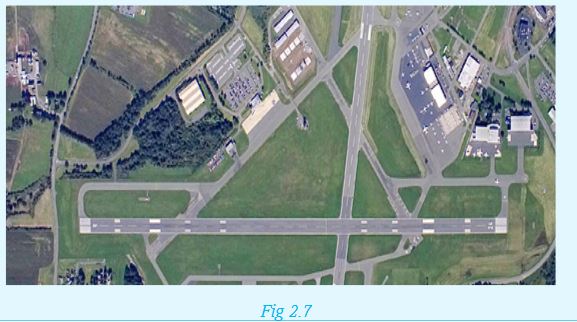
b) Aerial photographs
There are two types of aerial photographs. These are aerial oblique photographs and vertical aerial photographs.
(i) Aerial oblique photographs
These are photographs that are usually taken at an angle, typically 45 degrees. These photographs can cover a large area. The objects nearer the camera are usually larger than those far away.
(ii) Vertical aerial photographs
These are aerial photographs that are taken vertically above the land. In such photographs, only the top part of the features or objects can be seen. These photographs can be use for making maps.
Activity 2.5
In groups, study the following photographs. Classify them as either aerial oblique photograph or vertical aerial photograph respectively. Give reasons for your answer.

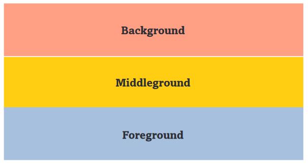
Parts of a photograph
Understanding the parts of a photograph helps us to describe it well.
Photographs have three main areas or parts. These are:
- Foreground
- Middle ground
- Back ground
The following diagram shows how the sub-divisions can be done on a photograph.
Activity 2.6
Study the following photograph and identify what is found in the foreground, middle ground and background
Foreground
The foreground is the area that is nearest to the camera. Objects in this area are always bigger and clearer than those in background.
Middle ground
This is the part in the centre of the photograph. Objects or features in this part are visible but not as clear as those in the foreground.
Background
This is the part that is furthest from the camera. Objects in the background are very small and may be unclear to the observer.
2.3 Importance of photographs
Activity 2.7
In groups of four, discuss the importance of photographs. Summarise the findings and make a class presentation. Use the following points to guide you.
1. Photographs are important sources of history and information when periodically taken and safely stored.
2. They show physical features such as appearance of a landscape or economic activities taking place in a given area.
3. Changes occurring in a place, person or object are recorded better in a series of photographs taken over a period of time.
4. Photographs are easy to take. One does not require special skills to take a photograph. This makes photographs an easy way of storing information.
5. They are easy to share because they are less bulky. Many copies can also be reproduced, making them an easy source to store and share information.
6.Aerial photographs are used for making maps.
END OF UNIT REVISION EXERCISE
1.Define a photograph.
2.In pairs, draw the parts of a photograph.
3.Discuss the importance of photographs.
4.Differentiate between the three parts of a photograph.
Unit 3: INTERPRETATION OF PHOTOGRAPHS AND VIDEO IMAGES
Key unit competence
At the end of this unit, you should be able to interpret the relationship between physical and human features on photographs and draw sketch diagrams of a photographIntroduction
In Unit 2, we defined photographs, identified different types of photographs and pointed out different parts of a photograph.
Activity 3.1
1.Working in groups, draw a table similar to the one given below in your notebook. Use the knowledge gained from the previous unit to fill in all the information required. Present your summary to the class for discussion. 2. Use the Internet, dictionary and other academic materials to differentiate between photographs and video images.In this unit, we will learn how to interpret photographs and video images. To achieve this, we will study in detail the following sub-units:
3.1 Types and divisions of a photograph
i) Types of photographs
From Activity 3.1, you must have identified the following types of photographs:
These two broad categories are further categorised as follows:
Activity 3.2
Study the following photographs carefully.
Working in groups of five:
1.Categorise each of the photographs into any of the five categories.
2.Explain which of the five categories of photographs is missing.
ii) Divisions of a photograph
These refer to the sections of a photograph.In Unit two, we identified the three major sections of a photograph. Apart from the three divisions identified in Unit 2, three more divisions can be made of a photograph as shown:

From the divisions above, the foreground, middle ground and background can therefore be further subdivided into three parts each. This is to precisely state or locate position of objects in a photograph. The following figure illustrates how this subdivision can be done.
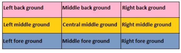
Activity 3.3
Draw the figure above in your notebooks. In each rectangle, indicate what is found in each of the nine parts identified, using the photograph given below.Activity 3.3Draw the figure above in your notebooks. In each rectangle, indicate what is found in each of the nine parts identified, using the photograph given below.
3.2 Identification of human and physical features on photographs and video images
The main difference between a photograph and a video image is that a photograph is a still image of an object while a video image is a display of moving pictures that may be recorded over a certain period of time together with sound.
a) Identification of human activities on photographs and video images
Activity 3.4
1.Identify the different human activities each of the following photographs is showing.
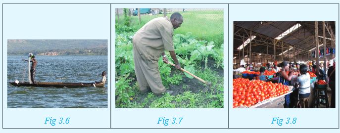
2. Obtain photographs from newspapers such as Newtimes, Umuseso and Umuvugizi published in 2016 that show various human activities. Display these photographs in class for others to see.
Human activities refer to the work done by people in order to earn an income, or improve their standards of living. The main human activities include farming, mining, forestry, fishing, trading, transport, settlement, manufacturing and processing.Human activities in video images are easy to identify. This is because they show how people carry out these activities, from the start to where the recording stopped. For example, a video recording can show how raw materials (such as sugarcane) is processed through various stages to final products (such as sugar or sweets).
Activity 3.5
1. Your teacher will play a video in class showing how milk is processed into any of the following products by Inyange Industries: Packed pasteurised milk, cheese or yoghurt. In groups, summarise the various stages and make a class presentation.
2. Susanne visited an irrigation farm in their rural village. She recorded a video that showed where the water was being obtained for this purpose, they type of crop being irrigated and water conservation measures being employed. Narrate how such a video is likely to be. Make your narration as interesting as possible
b) Identification of physical features on photographs and video images
Activity 3.6
1. Study the following photos carefully.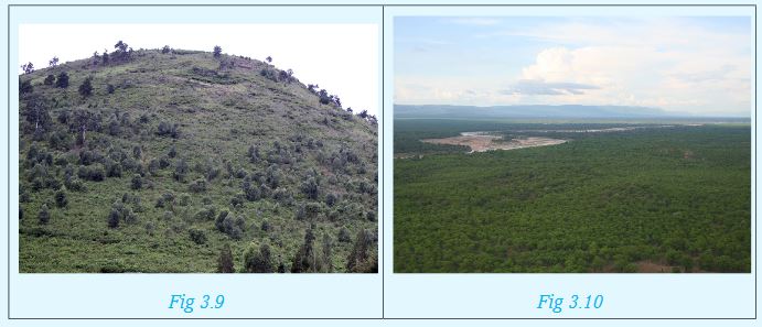
Identify the physical feature each of the photographs is showing.
2. Your teacher will play a video showing a visit to the national park. Working in groups, Identify the physical features you will identify in the video. Explain your answers through a class presentation.
Relief features that can be deduced from a photograph include mountains, hills, slopes, valleys, plateaus and plains.
3.3 Relationships between different features (human and physical aspects)
Activity 3.7
Using the following photographs, discuss in groups the relationship between human and physical aspects. Make a written report and a class presentation of your findings.
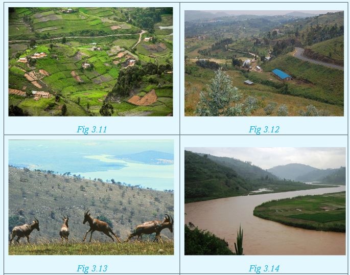
Physical aspects of the land refer to the nature of the landscape, that is, whether mountainuous, hilly or plain. There always exists a relationship between different features, that is, human and physical aspects. The nature of the landscape determines the various activities that may take place.
a) Mountainuous landscape may be an indication of a possible source of rivers, especially if it is forested.
b) Hilly landscape may be indications of a highland area, while dissected landscape in a hilly area indicate that the area has undergone erosion.
c) The type of drainage in a photograph can also provide a hint on the nature of the landscape. Swamps suggest a flat and waterlogged area; long and narrow lakes indicate faulting while a lake on top of a hill is an indication of a crater lake.
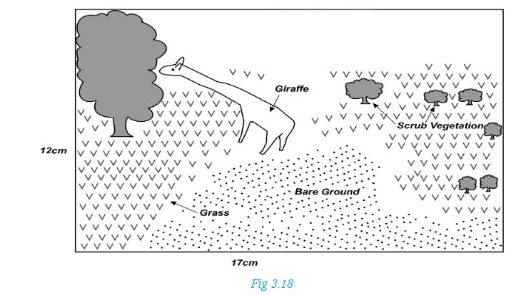
d) Human activities shown on a photograph are also dependent on the nature of the landscape. Crops like tea grow well in highland areas while a coconut plantation is evidence that the land may be a coastal area. On the other hand, large scale irrigation farming usually takes place in gently sloping areas. Dairy farming takes place in highland areas that are on the windward side while pastoralism and tourism thrives on the leeward side.
e) Infrastructural development in an area is also dependent on the landscape. A road between two hills for instance indicates that the land is characterised by passes. A winding railway line is an indication of a rugged landscape.
f) Vegetation type shown on a photograph can also indicate the nature of the landscape. For instance, scattered trees shrubs can show the leeward side of a mountain or a dry, fairly flat arid land.
g) Settlement patterns as may be shown on photograph are also determined by the nature of the landscape. Areas with steep slopes are usually avoided while those that are relatively flat are preferred.
3.4 Drawing sketch diagrams from photographs
Activity 3.8
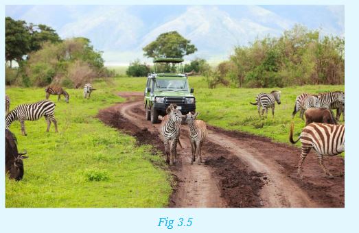
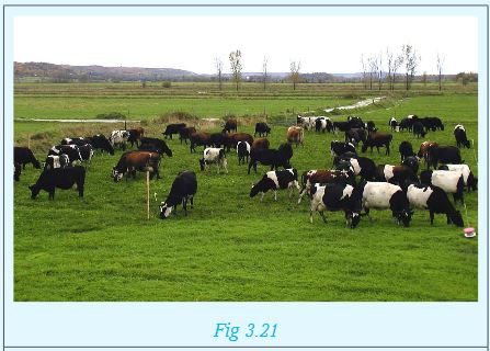
The photograph on page 34 shows wildlife in their natural habitat.
1.Identify the animals shown.
2.Identify the types of vegetation on the left foreground and right background.
3.Which other feature can you see from the photograph?

Before you draw a sketch of a photograph, you need to highlight the main features shown. It is also good to point out their locations in the area covered by the photograph.
Procedure:
1.If the photograph given is rectangular, draw a rectangular box to fit in the details. If it is squared, draw a squared box. The size of the box can be the same as that of the photo, half its size or twice its size.
2.Using clear pencil lines, draw the main features in the frame, ensuring they remain proportional to those in the original photo. Try to locate them in your frame as accurately as possible.
3.Using symbols and a key, label the features on the sketch.
4.Give your sketch a title.
The sketch of the above photo will appear as follows:
Sketch of a Photograph showing Features
Activity 3.9
1. The procedure can be used in drawing a sketch as shown below:
a) Identify the feature shown by the photograph whose sketch has been drawn.
b) What are the main focal points in the photograph?
c) What is the most likely title that can be given to the sketch?
2. Draw sketches of the following photographs. Ensure your sketches have a key for the main features, a title and a frame.
3.5 Reduction and enlargement of photographs
a)Reduction of photographs
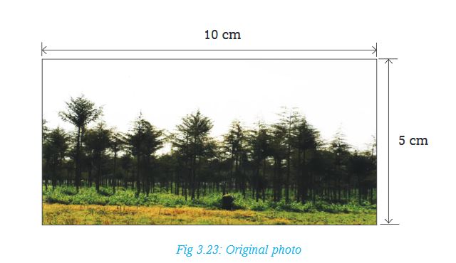
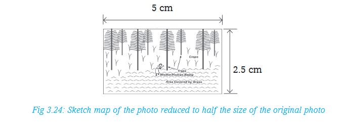
You can draw a sketch map of a photograph, in a rectangle or square smaller than the original photograph, for example to half its size.To do this:
i. Measure the dimensions of the photograph. If the length is 10cm and the width 5cm, divide them by 2, to get 5cm by 2.5cm rectangular box.
ii. Identify the main features to be shown on your sketch. Maintain their accurate position as much as possible.
iii. Give the key and title of the sketch.
b) Enlargement of photographs
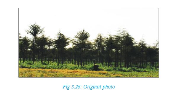
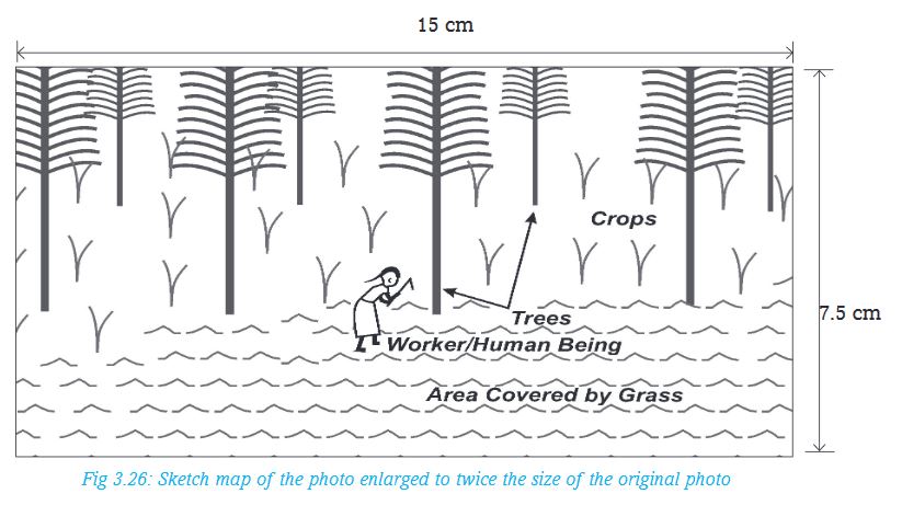
You fit the details shown on a photo on a larger frame than the actual size. The drawing will be larger than the original photo. For example, this can be one and a half times or twice the size of the original photo.Enlargement by 1.5 of the original size:
i.Measure the dimensions of the photograph. If the length is 10cm and the width 5cm, multiply them by 1.5, to get 15cm by 7.5cm rectangular box.
ii.Identify the main features to be shown on your sketch. Maintain their accurate position as much as possible.
iii.Give the key and title of the sketch.
Work to do
Your teacher will provide you with a photograph for this exercise.
i. In pairs, draw a sketch using the photograph you have been provided with. Fit the details in the frame provided below.
ii. Identify the main features to be shown on your sketch.
iii. Draw the sketches of the main features. Maintain their accurate position as much as possible.
iv. Give the key and title of the sketch.

END OF UNIT REVISION EXERCISE
1.Write brief notes on each of the following types of photographs:
(a) Ground close-ups
(b) Oblique photographs
2.Describe the procedure you will use when drawing a sketch from a photograph.
3.Explain briefly how you can accurately show features on a sketch drawn from a photograph.
Unit 4: TECTONIC PROCESSES
Key unit competence
At the end of this unit, you should be able to explain the tectonic theory that has shaped the landscape we see.4.1 Introduction to landform processes
Read the following story.
Gladwel was travelling to her parent’s home in Rusizi. On the way, she saw many physical features. She saw hills, valleys, plains and mountains. She also saw rivers flowing within the valleys and forests growing on the slopes of hills. At some point, the road was winding up or down a certain hill. In such areas, the driver of the bus drove carefully. Areas that were on the plains had many human activities such as farming and trade.
Suddenly, she remembered what her Geography teacher once said: “If you look around your school or home, you will see various features on the surface of the earth. Some of these features may be found on your way to school, church or mosque. When you travel from one place to another, you may see these features or even more.”
In the story above, Gladwel observed some of the physical features on the earth’s surface.
Activity 4.1
Name the physical features Gladwel observed.
The features you have named above occur as a result of tectonic movements.
Activity 4.2
Using the Internet and other geographical materials, define the term tectonic movements.
The internal landform processes are caused by:
a)Tectonic processes
b)Tectonic forces
c)Tectonic movements
Activity 4.3
Differentiate between the three terms mentioned above.
Internal land-forming processes (or tectonic processes) are those processes operating inside the earth. These processes result in the formation of features on the surface of the earth. They are caused by tectonic forces. This results into tectonic movements. Tectonic movements can be horizontal (lateral) or vertical. They cause the following processes to occur within the earth, namely:
(i) Folding
(ii) Faulting
(iii) Warping
(iv) Vulcanicity
(v) Earthquakes
Activity 4.4
In groups of five:
1.Discuss the meaning of each of the terms given above.
2.Some of the resultant effects of earth movements are dangerous to life. Using examples, explain how true this statement is.
Pick one amongst yourself to present the findings to the class.
4.2 Folding
In this section, we will explain the following concepts:
• Meaning of folding
• Causes of folding
• Resultant features of folding
• Examples of areas of folding
• Effects of folding
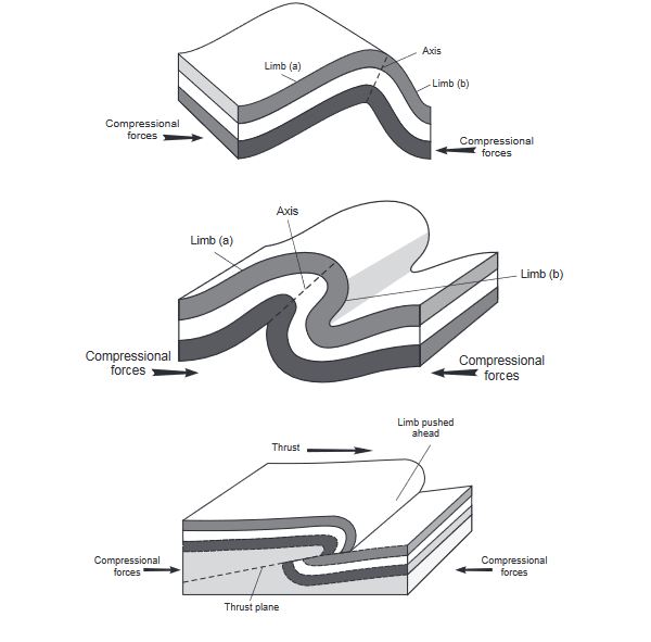
4.2.1 Meaning of folding
Activity 4.5
In groups, use a paper to illustrate how folding takes place. Place the paper on the table then push from both ends inwards.
Explain what you see.
Folding is a process that occur within the rocks of the earth’s crust. This process causes the rocks to bend upwards or downwards. The process is caused by tectonic forces that operate horizontally within the earth’s crust.
Activity 4.6
Identify what the paper in Activity 4.5 above represent.
Just like the paper in Activity 4.5, when tectonic forces move towards each other, they cause the rocks in between the forces to be compressed. This means, they get squeezed and in the process, these rocks bend upwards and downwards. The forces acting in this manner are referred to as compressional forces.

The parts of the earth that bend upwards are called anticlines or upfolds. Those parts that bend downwards are called synclines or downfolds. The amount of folding in the rocks and the features that result from it depend on the strength of the forces involved. This in turn determines the nature of the features that form on the surface of the earth.
4.2.2 Resultant features of folding
The process of folding causes sizeable features that can be seen on the surface of the earth. The most common features resulting from folding are fold mountains. They form the world’s highest mountains.
Other resultant features of folding are:
• Inter-montane (or intermont) plateaus
• Valley and ridge landscape
• Rolling plains
• Fold mountains
• Inter-montane (or intermont) basins
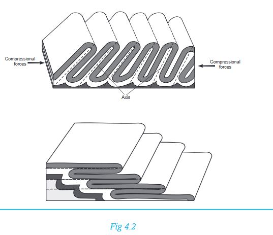
Activity 4.7
1. Each of the terms give above is explained below. Match each explanation with the term it is referring to.
(a) They result when weak compressional forces transform the relatively flat lowland into very gentle low anticlines and broad but gentle synclines.
(b) This landscape is made up of a series of high anticlines and deeper synclines. Forces that are uneven in strength cause anticlines to form ridges with one side being gentle while the opposite side is steeper.
(c) They are relatively level surfaces of considerable extent, that lie high up within the fold mountains and are surrounded by higher mountain peaks. They represent areas that resisted folding when compression forces were at work. The surrounding areas however, were folded and rise up above these surfaces.
(d) They are depressions on the surface of inter-montane plateaus. They were formed during the formation of the plateaus when some parts of these plateaus subsided and ended up as basins.
2. Look at the following illustrations. They represent the various types of folds. Identify the type of fold each illustration is showing from the list given below.
• An asymmetrical fold
• An overfold
• A recumbent fold
• An overthrust fold
• Isoclinal folds
4.2.3 Areas of folding
Many areas that have experienced compressional forces display rocks that have undergone folding. However, the most conspicuous features are fold mountains.Therefore some examples of areas of folding are those where fold mountains occur. Examples of fold mountains include Atlas Mountains in northwest Africa, Cape Ranges and Drakensburg in South Africa and Folded hills in the Eastern Province of Rwanda.
Activity 4.8
In pairs, use an atlas or information from the Internet to identify areas in Rwanda where folding has taken place. Find out if there are fold mountains in Rwanda. Write your findings for further discussion in your discussion groups.
4.2.4 Effects of folding
Activity 4.9
In pairs, read the following effects of folding. Categorise each of them either as a positive or negative effect. Give reasons for your answer.
(a) Severe folding distorts the land turning it into a rugged landscape that is unsuitable for farming and settlement.
(b) During folding, valuable minerals could be brought closer to the surface, making their mining easier. However, some valuable minerals could also end up being buried deep and therefore inaccessible.
(c) The process of folding weakens the crustal rocks causing them to develop cracks. These provide weak areas through which molten magma can escape from the interior of the earth thus triggering volcanic activity.
(d) Fold mountains form a barrier to transport and communication.
(e) The mountains, especially in the olden days, formed a protective barrier against enemies on the opposite side.
(f) The mountains formed from folding modify the climate of the area where they exist. Some areas receive abundant rain while others receive less. Higher areas are cooler than lower areas.
(g) Mountains are a good water catchment area and are therefore a source of rivers whose water can be utilised in various ways in the surrounding areas and far places.
The scenery created by fold mountains is unique and attractive to look at. Therefore, fold mountain areas are a tourist attraction.
4.3 Faulting
Activity 4.10
In groups of five, use a ruler to explain how faulting takes place. Place the ruler on the table then push from both ends inwards. Explain what you see.
The ruler used in the activity above will break when compressed from both ends. This illustrates what faulting is.
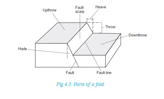
Faulting is the process that causes the fragile rocks of the earth’s crust to fracture and form cracks. This process is caused by tectonic forces that act horizontally or vertically within the earth’s crust. As the rocks are folded due to compressional forces, cracks do form within the folding rocks because rocks are quite rigid and therefore do not bend like rubber. These cracks are called faults.
Activity 4.11
In groups of four, collect clay or plasticine and mould ribbons with it. Pull the ribbons and explain what happens.
The force you applied to the plasticine or clay is similar to horizontal forces within the earth’s crust. These are called tensional forces. These forces cause the affected rocks of the earth to stretch and sometimes even break. The parts of the resultant feature is as shown below:
4.3.1 Types of faults
The process of faulting causes various types of faults to occur within the rocks. The types of faults that form are largely influenced by the way tectonic forces that cause them, operate. The following are common types of faults:
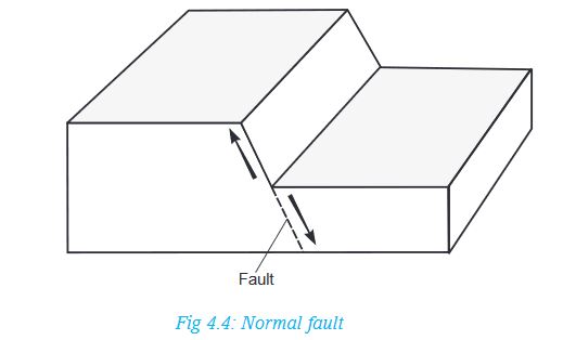
(a) Normal faults: These are faults that result from tensional forces. As land is pulled apart, one block of land slides downwards against the other one. These faults have formed in the East African Rift Valley.
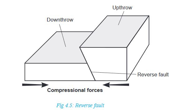
(b) Reverse faults: These are also known as reversed faults. They are caused by compressional forces. A fault occurs where the forces push towards each other and one block of land on one side of the fault is pushed up over the other.
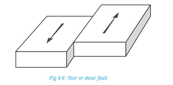
(c) Tear or shear faults. These are also known as strike-slip or wrench faults. They are a product of two opposing forces which move parallel to each other. A fault forms in the region separating the two forces and the blocks of land on both sides of the fault slide past each other. In this situation, land is displaced horizontally. Very extensive shear faults across continents are called transform faults and are associated with tectonic plate boundaries.
Activity 4.12
In groups of four, discuss and compile the findings on how the following types of folds occur.
• Thrust faults
• Anticlinal faults
Draw diagrams to represent the two types of faults. Prepare a class presentation.
4.3.2 Landforms resulting from faulting
The following are some examples of the landforms that result from faulting:
• Escarpments
• Fault steps
• Rift valleys
• Fault blocks
• Tilt blocks
Activity 4.13
Use geographical documents, the Internet and diagrams to find out the mode of formation of the various features resulting from faulting. In groups, discuss the processes of formation of different relief features. Present your findings to the class. In your presentation, include:
(a) How each feature is formed
(b) Examples of these features
(c) Diagrams to show how each of them is formed
4.3.3 Areas of faulting
Faulting and the resultant features are associated with areas where folding has taken place. In East Africa, areas of faulting are mainly within the Great Rift Valley region. This region starts from Syria, through the Red Sea, Ethiopia, Kenya, Tanzania, Malawi and Mozambique. It has a branch from Lake Rukwa area in Tanzania, past Rwanda into western Uganda.

4.3.4 Effects of faulting
The process of faulting and the resultant features have an impact on both human and physical environments. The effects can have a positive or negative influence. Some of these effects are:
(a) Faulting causes disjointing of land. This leads to interruption of transport lines such as railways, roads and pipelines. Even construction of such lines is difficult across escarpments.
(b) When land subsides after faulting, many people may die in the process when buildings collapse on them or when they are buried alive in the resulting fractures.
(c) When faulting occurs across a river valley, it can cause a river to change its direction of flow or even disappear into the ground along the fault.
(d) In some regions where faulting has occurred, the fractures may extend deep down into the earth. These fractures may form easy passage for hot water or steam to come to the surface. This results into geyser and hot springs that can be harnessed for production of geothermal electricity.
Activity 4.14
In pairs, discuss other effects of faulting. Use geographical documents, the internet and atlases.
4.4 Warping
This is a process involving a gentle deformation of the earth’s crust over a considerable area. The landforms associated with warping are few. Common ones are:
i) Broad shallow basins
ii) Low uplands or hills
Areas of warping in Africa
1. In East Africa, large scale warping occurred in central Uganda where it formed the current Lakes Victoria and Kyoga basins.
2. The western side of the plateau upwarped to form highlands in western Uganda and eastern Rwanda.
3. In eastern part of Rwanda, downwarping occurred in some areas that resulted in the formation of relatively large basins where water accumulated to form lakes such as Lake Muhazi.
4. In western Kenya, south eastern Uganda and north eastern Tanzania, minor upwarp occurred to form the Lake Victoria basin.
5. The Lake Victoria basin also tilted slightly northwards towards Lake Kyoga. Water that overflowed from Lake Victoria ended up in the Kyoga basin.
6. Downwarping also created several smaller basins on the plateau. Many of these also formed lakes such as Nakivali, Kachira and Wamala in the west as well as Bisina and Opeta in eastern Uganda.
Activity 4.15
In pairs, draw the map of Africa. On it, mark the areas where downwarping has occurred. Show the features that have formed in these areas.
4.5 Vulcanicity and volcanicity
Activity 4.16
Using a dictionary, differentiate between:
a) Vulcanicity and volcanicity
b) Magma and lava
Write short notes about each term. Present your findings to the class.
4.5.1 Causes of vulcanicity
The earth has seven continents. Our country Rwanda, is in Africa, which is one of the seven continents.
In pairs, name the other six continents.
Each continent is carried by large, rigid blocks called tectonic plates. These plates float on hot and softer layers found inside the earth. The plates also move on these softer layers, towards each other, past each other or away from each other. Vulcanicity is usually associated with these plates.
There are three main causes of vulcanicity. These are:
a) Where tectonic plates move away from each other: When this happens, they create a gap where volcanic eruptions occur. This mostly happens under water. Magma rises from great depths below to fill the space created. The rate at which the plates move apart is about 10 cm in a year.
b) Where tectonic plates move towards each other: In this case, one plate (usually the oceanic plate) is pushed underneath a neighbouring continental plate. The edges of the oceanic plate are melted as they sink into the molten mantle. The wet sediments and sea water sink with it. This causes violent eruptions that generally contains ash.
c) Where tension and thinning of the earth’s crust occurs: This is usually far away from tectonic boundaries, where materials can find their way through weak areas of the crust and escape to the surface. One such an example is the Hawaian islands. In this group are volcanoes associated with faults and the rift valleys.
4.5.2 Types of volcanic features
There are two main types of volcanic features. These are intrusive features and extrusive features.
Activity 4.17
Research from various geographical documents the meaning of intrusive and extrusive volcanic features.
Write brief notes about each and present your findings to the class.
Volcanic eruptions can be classified according to the passages through which materials reach the surface. Molten materials can come out of the ground through a single hole called a vent. An eruption associated with this is referred to as central vent eruption. These eruptions are usually explosive and violent. They tend to bring forth very viscous lava that accumulate around the vents and not spreading very far from the source.
The other way materials can reach the surface is through line cracks or faults. Materials come out of the ground along the entire crack, also known as a fissure. These are referred to as fissure eruptions and are generally quiet, spewing out fairly fluid lava that spreads over a wide area.
Activity 4.18
Research more about the two types of eruptions mentioned above. Find out:
1. An eruption that forms the highest features such as mountains.
2. An eruption that leads to the formation of lava plateaus.
Give reasons for your answers.
4.5.3 Landforms resulting from vulcanicity
The landforms resulting from vulcanicity are quite varied. They can be classified according to the type of vulcanicity. These are:
1. Intrusive features
2. Extrusive features
Intrusive features
These are features resulting from vulcanicity that form under the ground. They include:
(a) Dyke: This is a mass of solidified materials that forms across (or cuts vertically) the layers of the crustal rocks.
(b) Sill: A sill is a mass of solidified materials that forms a horizontal layer inside the earth’s crust. It may also be inclined depending on the arrangement of the layers of the surrounding rocks that are intruded.
(c) Batholith: It is a huge mass of solidified magma. It intrudes the rocks of the crust and spreads over a broad area beneath the earth’s crust. It forms at a deeper level than the dyke or sill.
(d) Laccolith: This is a mushroom-shaped intrusion with a flat base. It is formed in the same way like a sill. However, the solidified materials form around the passage through which it came. It spreads along the bedding plane between layers of the crustal rocks.
(e) Lapolith: This is a very large mass of solidified material which occupies the space between two layers forming a basin shape. Materials from the interior of the earth come up in the same way as that of a laccolith. However, these materials spread over a considerable distance between the rock layers of the crust forming a basin-like shape.
Extrusive features
These are features resulting from vulcanicity that form on the earth’s surface. They include:
(a) Volcanic mountain: It is a high volcanic hill with steep sides and a convex slope. It is formed when lava coming out of the earth’s surface pushes the dome upwards, thus increasing its height.
(b) A volcanic plug: This is also called a volcanic neck or a spine. It is a remnant of a column of magma that cooled and solidified inside a vent. Such vents were once insulated by the lava which formed the volcano. After a long time, materials forming the sides of the volcano are slowly eroded. Eventually the column of magma is exposed (or sticks out) as the slope is lowered.
(c) Lava plateau: This an extensive and fairly level upland whose surface is covered by lava. There are low lying regions whose surface is below 500 metres above sea level and also covered by lava flows. These are referred to as lava plains.
(d) Crater: This is a funnel-shaped depression that forms at the mouth of a volcanic vent. It marks the upper end of a vent. Water collects in some craters to form crater lakes. A good example is Bisoke Crater lake found on Mt. Bisoke.
(e) Caldera: This is a very large basin-shaped depression that forms on top of a volcano. It is originally a crater which becomes enlarged.
The diagram below shows some of the features that form as a result of vulcanicity. It contains both intrusive and extrusive landforms.

Note: Hot springs and geysers are an example of resultant features of vulcanicity.
- A hot spring is a place where hot water comes out from the ground. It is also known as a thermal spring.
- A geyser is a jet of hot water or steam which shoots with a degree of violence from the ground either continuously or at intervals. Nyamyumba Hotspring, found seven kilometres from Rubavu is an example.
Activity 4.19
In pairs:
1. Explain the difference between a caldera and a crater.
2. With the help of diagrams, explain how a crater and a caldera forms.
3. Carry out as research from geographical documents and the Internet about the following volcanic features explained above. Using diagrams, show how they appear after formation in your note books.
(i) Laccolith
(ii) Lapolith
(iii) Volcanic plug
4.5.4 Types of volcanoes
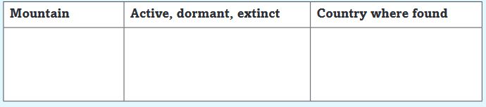
Volcanic activity is going on in various parts of the world while in others it is quiet for a while. There are however, those areas where it is completely silent. In terms of volcanic activity, volcanoes are classified into three categories namely, active, dormant and extinct.
Activity 4.20
1. In groups of three, describe each of the following terms in reference to volcanoes:
a) Active volcano
b) Dormant volcano
c) Extinct volcano
2. The following are examples of the various types of volcanoes found in East Africa.
• Nyamuragira • Nyiragongo
• Bisoke • Karisimbi
• Muhabura • Gahinga
• Kilimanjaro
• Ngorongoro
• Mt Kenya
Copy and complete the following table. Ensure you classify each mountain mentioned above in the table below.
4.5.5 Effects of vulcanicity
The process of vulcanicity and the resultant features have a significant effect on both the physical and human environment. The effect may be positive or negative.
Activity 4.21
The following are the effects of vulcanicity.In groups of five, classify each point as a positive effect or a negative effect. Give reasons for your answers. Present the findings to the class.
(a) Many types of volcanic lava, upon weathering, form fertile soils which are of agricultural value and in which a variety of crops may grow. This is of economic importance to the people.
(b) Geysers are harnessed to produce geothermal electricity. Geothermal sites in Rwanda are found in areas such as Rubavu, Kinigi and Karisimbi. The sites are found in the western region of the country in Rubavu District near Lake Kivu
(c) The variety of volcanic features formed attract tourists who in turn bring into a country, the much needed foreign exchange that can be used for further development.
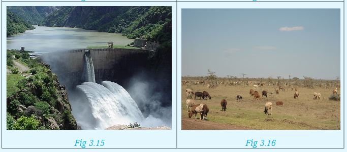
(d) Many volcanic mountains receive relief rainfall on their windward slopes. They become water catchment areas and a source of rivers. The waters of these rivers can be used to generate electricity, for irrigation in the lower lands and for domestic and industrial use. Agriculture and forestry can thrive on the wet slopes too.
(e) Many varieties of igneous rocks are used in the construction industry for building roads, bridges and houses.
(f) A variety of hot springs and geysers are used by some people as health spa. It is believed that the water and the minerals contained therein have healing effects.
(g) When volcanic eruptions occur, they may lead to loss of life and property. Lava flow has been witnessed in areas near Lake Kivu, from the eruption of Mt. Nyamulagira. In 2002, the mountain erupted, leading to extensive damage to the city of Goma, and destruction of wildlife in the surrounding areas, reaching as far as Lake Kivu in Rwanda in Rubavu District.
(i) The presence of a number of volcanic features becomes a barrier to construction of communication lines.
4.5.6 Distribution of volcanoes
Volcanoes are mainly found in those parts of the earth’s crust which are weakened by tectonic forces and thus provide easy passage for magma to escape to the surface. These are areas that have experienced faulting like in the rift valley regions. This include areas within the Great Rift Valley whose western arm covers parts of Uganda, Rwanda, Congo, Burundi and Tanzania.
Activity 4.22
Use the map on page 49 to identify the areas in Rwanda which are most likely to be affected by volcanic eruptions. Tabulate your findings detailing the area, district, and province where this is likely to happen.
4.6 Earthquakes
An earthquake is a sudden and rapid shaking or trembling of the earth’s crust. In Greek it is called seismos.
Activity 4.23
Use your dictionary to find out the meaning of the following terms associated with earthquakes. Write short notes about each of them.
• Epicenter
• Seismic focus
• Seismometer
• Earth tremor
4.6.1 Causes of earthquakes
Most of the earthquakes are caused by tectonic forces which cause vibrations or shocks within the earth’s crust. These shocks are then transmitted from the point of origin outwards. This point is known as the seismic focus,hypocenter or the origin. This is inside the earth. The position on the surface of the earth that is vertically above the seismic focus is called the epicenter. Many earthquakes are violent but those that are least violent are known as earth tremors.
Activity 4.24
Earthquakes are caused by natural reasons such as tectonic movements orvulcanicity. However, in some cases, they result from human activities.
In groups of four:
1. Explain how tectonic movements and vulcanicity may cause an earthquake.
2. Discuss some of the human activities that may cause earthquakes.
Apart from tectonic movements, vulcanicity and human activities, the following are other causes of earthquakes:
1. Gravitative pressure: The force of gravity acts on the rocks of the earth’s crust lying over the empty chambers left when magma escapes to the surface. The rocks collapse inwards and this causes the ground to shake.
2. Isostatic adjustment: Some parts of the earth’s crust lose materials while others gain as the materials are added onto the surface causing it to sink. Beneath the crust, materials may also move away into other regions where they push the crust upwards. The up and down movements of the crust can trigger tremors in the earth.
3. Excessive energy release within the mantle: Radioactivity within certain parts of the mantle may result in excessive release of energy in an explosive manner. This can set off shock waves that translate into earthquakes.
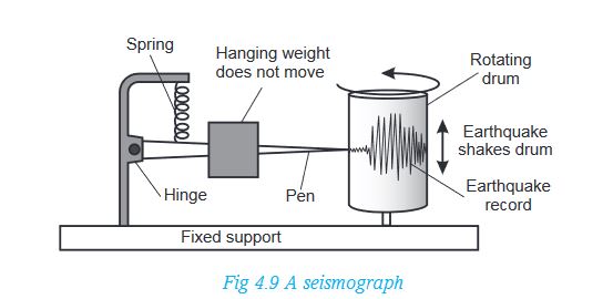
4.6.2 Measurement of earthquakes
A seismograph is the instrument used to measure earthquake shocks in form of waves. It has a delicate instrument that receives the impulses of the shocks. This is called a seismometer. These impulses are at the same time recorded on a chart that looks like a graph and attached to a drum. This chart is called a seismogram. It is on this seismogram that the reading and interpretation of seismic waves is made.
The strength of an earthquake is measured using either its intensity or its magnitude.
Activity 4.25
The intensity and magnitude of an earthquake are measured by different scales.
1. In pairs, find out the difference between:
• The intensity of an earthquake
• The magnitude of an earthquake
2. Identify an instrument used to measure:
• The intensity of an earthquake
• The magnitude of an earthquake
4.6.3 Consequences of earthquakes
Activity 4.26
1.When earthquakes occur, they have always been thought to cause negative effects. Find out any positive effects earthquakes may have.
2.In groups of five, study the following photographs showing the effects of earthquakes. Write down brief notes on what you see.
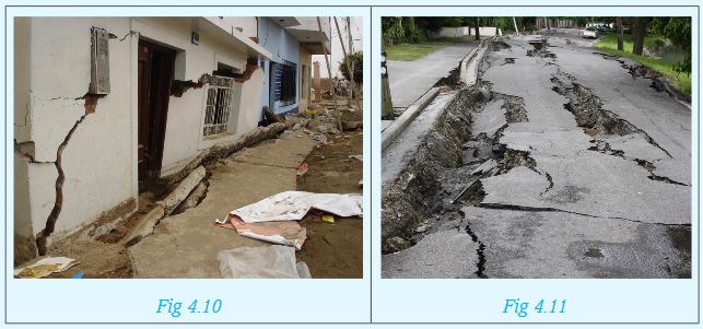
The effects of earthquakes vary depending on the magnitude of the earthquake in question. Some can be disastrous while other are mild. The following are some of them.
(a) The effect of earthquakes in densely populated areas can be disastrous. Loss of human life and destruction of property are common effects of earthquakes.
(b) Some powerful earthquakes cause development of violent motions in the earth making the surface look like a series of waves.
(c) Violent earthquakes can set off the processes of folding, faulting and even vulcanicity. It should be noted however, that these processes also cause earthquakes.
(d) When a massive earthquake occurs on the sea bed, it rocks the sea floor resulting in development of a very unusually powerful wave called a tsunami. These are common in Japan and surrounding ocean.
(e) Earthquakes are known to cause vertical or lateral displacement of parts of the land. Parts of the sea floor can be raised or lowered as well.
(f) Landslides are common effects after occurrence of strong earthquakes on steep areas.
4.6.4 Major regions of earthquakes
The regions where earthquakes occur frequently are referred to as seismic zones. These are associated with areas of crustal weakness such as faulted and folded areas and volcanic regions. The major regions include:
(i) The region across Western Province in Rusizi, Nyamasheke and Rubavu.
(ii) All regions along the boundaries of the earth’s tectonic plates.
(iii) The regions of the earth’s rift valleys, where the blocks of land periodically slide against each other along the fault planes as the earth tends to settle.
END OF UNIT REVISION QUESTIONS
In groups:
1. State the causes of earth movements.
2. Using diagrams, explain the formation of normal faults and reverse faults.
3. List examples of fold mountains in Africa.
4. Mention areas of warping in Rwanda.
5. Using geographical knowledge, explain the effects of earthquakes.
Unit 5: THE EXTERNAL LANDFORM PROCESSES
Key unit competence
At the end of this unit, you should be able to investigate how erosion and weathering have shaped the landscape.Introduction
The main external land forming processes are erosion, weathering and mass wasting. These processes shape the way the landscape looks like.
Activity 5.1
In pairs, use different geographical sources to define the following terms:
a) Soil erosion
b) Weathering
c) Mass wasting
5.1 Soil erosion
This refers to the removal of the topsoil by agents of erosion. Soil erosion takes place in two steps:
• Breakdown of soil particles
• Transportation of the broken particles
5.1.1 Agents of erosion
Agents of erosion are the things that transport the top loose soil from one place to another. The agents of erosion include:
a) Running water
b) Wind
c) Moving ice
d) Gravity
e) Animals
f) Humans
NOTE: All these factors are interdependent. This means that one factor may aid the other in causing soil erosion. Few are the cases when one factor can independently cause erosion.
a) Running water: Flowing water on the surface of the earth can carry loose soil particles from one place to another. The amount of soil that can be carried depends on:
• The volume of flowing water
• Speed of water
• Slope of the land
• Nature of the land, that is, whether bare or with vegetation
b) Wind: The strength of the wind determines how much erosion it can cause. This also depends on how long the wind blows, as well as how bare the land is.
c) Moving ice: This is also called a glacier. The extent of erosion a glacier can cause depends on:
• The volume of the glacier
• Speed of the glacier
• Slope of the land
d) Gravity: This is the force that pulls things towards the centre of the earth. It mainly causes erosion on slopes by accelerating the movement of agents such as water and ice. The larger the amount of soil to be carried the greater the effect of gravity.
e) Animals: Animals, both large and small, cause erosion in many ways. Burrowing animals dig out the soft, loose soil which is then easily transported down slope. Larger animals on the other hand tramp on the vegetation leaving the land bare. Those with hooves loosen the bare soil making it easy to be carried by other agents such as glaciers, water and wind.
f) Humans: Various human activities may directly cause soil erosion. This includes ploughing near river banks and down slope. Sometimes, people clear vegetation either for settlement or farming. This makes it easy for other agents of erosion to take effect.
Remember!
The effects of soil erosion can only be avoided if it is controlled in its initial stages. This is easier than trying to reverse the situation in its advanced stages. It is also cheaper and time saving.It is our responsibility to take care of the environment.
We can achieve this by planting trees and ensuring good farming practices. For the future generations to benefit from the environment, we need to conserve it.
5.1.2 Types of erosion
Soil erosion takes place through the following ways:
On bare land, rain drops have a big effect on the top, loose soil. The impact of the drops breaks and displaces the soil particles. This causes them to be thrown away from their original positions in a splash. This is what is called splash erosion.
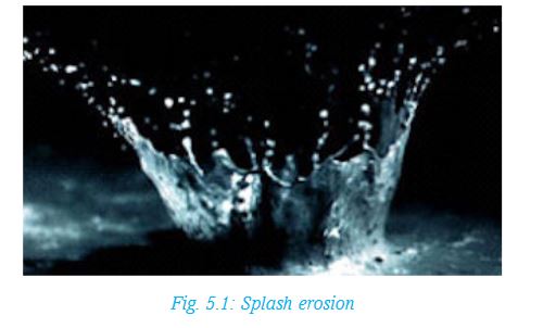
Splash erosion is the first stage of the erosion process.
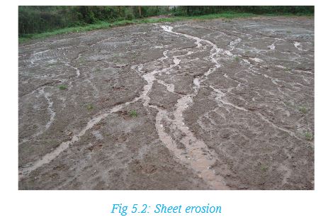
With continued rainfall in gently sloping areas, rain water spreads out over a large area. As it slowly moves, it carries the loose, top thin layer of soil. This process is referred to as sheet erosion. The effect of sheet erosion is not easily noticeable since it involves a thin layer of soil.
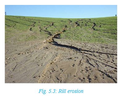
Wind erosion can also cause sheet erosion. It is common in dry areas with strong winds. Such areas also have limited or no vegetation cover. This results in sheet erosion and the formation of sand dunes and drifts. Uncontrolled sheet erosion caused by water creates small channels in the soil. These channels are called rills. Advanced erosion, called rill erosion, then takes place as the small channels widens over time.
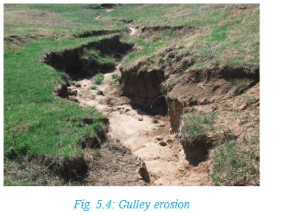
With continued erosion, the rills get enlarged to become gullies. These are large gaping channels that carry large volumes of soil during heavy downpours. Such a type of erosion is called gulley erosion.
5.1.3 Causes of erosion
Soil erosion can be caused by natural factors as well as human factors.
i) Natural causes of soil erosion
• Heavy rainfall
• Steep slopes
• Winds
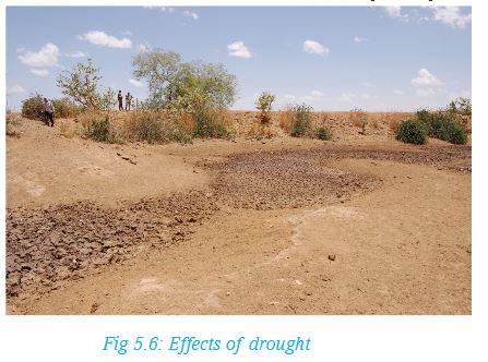
• Drought
• Increase in wild game population
Each of these causes is explained below.
a) Heavy rainfall: Excessive rainfall causes surface run-off. When this occurs on bare land, it causes soil erosion.
b) Steep slopes: They increase the speed of flow of water on the surface. This increases the rate at which erosion can occur.
c) Winds: Strong winds are capable of causing sheet erosion. This occurs in areas with little or no vegetation. Vegetation acts as wind breakers, lack of which promotes erosion.
d) Drought: Vegetation dries up during long periods of sunshine and unreliable or no rainfall at all. Reduced vegetation cover increases chances of erosion.
For example, animal hooves easily loosens the soil, making it easy to be carried away. Winds and water also carries such loose soil away easily.
e) Increase in wild game population: When wild animals are many, they eat and trample on vegetation. This may be to a point when the land is left almost bare. In the long run, this can cause erosion.
ii) Human causes of soil erosion
Some human activities cause the loosening of the soil making it easy to be carried away. Clearance of vegetation exposes the land to agents of erosion.
Activity 5.2
In groups of five:
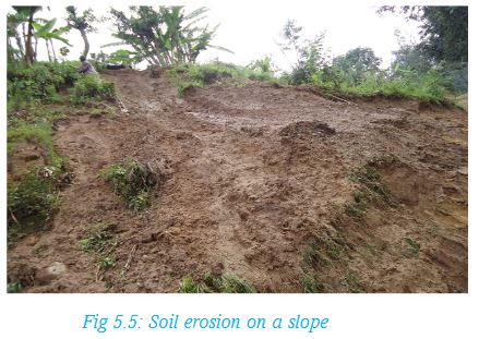
a) Study the following photograph carefully.
Explain the factors that may easily cause soil erosion
How can soil erosion be avoided in the area shown by the photograph?
b) Explain how the following poor methods of farming can cause soil erosion:
• Bush fallowing
• Monoculture
• Ploughing near riverbanks
c) Carry out a field study from the local environment to find out how the following human factors can cause soil erosion. Research widely from various geographical documents as well as the Internet.
Complete the following table to be used in your class presentation.

5.1.4 Effects of erosion on landscape
When soil erosion is not controlled in its initial stages, it may lead to serious problems. Some of these are:
a) Sheet erosion and rill erosion causes the fertile top soil to be carried down slope.
b) Gulley erosion creates deep trenches into the soil making it unsuitable for settlement, agriculture and construction.
c) Gullies also make the land to lose its original beauty.
The following photograph shows land that has been destroyed by gully erosion.

Soil erosion can also lead to:
• Soil degeneration: This is the loss of soil fertility. It occurs when the fertile top soil is carried away by agents of erosion.
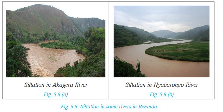
• Siltation in rivers and lakes: When soil is washed away by running water, it may end up in nearby rivers or lakes. This causes the water to be brownish in colour.
• Desertification: If the soil is eroded to a point where it cannot support plant growth, this can easily cause desertification.
• Landscape destruction: Soil erosion makes the land to look ugly.
5.2 Weathering
Soil erosion is the removal of the top soil by agents of erosion. On the other hand, weathering is the soil forming process.
Activity 5.3
In groups of three, use the Internet, dictionary and other geographical documents to:
• Identify other differences between soil erosion and weathering.
• Explain which of the two processes occur first.
5.2.1 Forms of weathering
Weathering occurs when rocks break down into smaller particles in situ (that is, without movement). Further breakdown of these rock particles results into even smaller particles that form soil.
There are some factors that affect the rate at which weathering takes place. These include the removal of the weathered materials by processes such as erosion and mass wasting. This is because erosion and mass wasting exposes the rock to further breakdown by agents of weathering.
Agents of weathering are the elements in the environment that directly influence the breakdown of rocks into smaller particles.
There are three forms of weathering. Each is explained in the following table.

We will discuss more about these forms of weathering in Unit Seven.
5.2.2 Causes of weathering
Weathering is caused by the following factors:
a) Climate (temperature and rainfall)
b) The slope
c) Plants, animals and human activities
d) Time
Let us look at each of these factors:
a) Climate
The main elements of climate that cause weathering are sunshine and rainfall.
• The amount of sunshine determines the heat responsible for expansion of the rocks. At night, contraction occurs within the rocks. This alternate expansion and contraction causes the rocks to break down.
• Rainfall provides water that dissolves minerals in rocks causing them to crumble. Some rocks absorb water, which enlarges and softens them. This causes them to break down easily.
b) Slope
After rocks have broken down, the slope determines the rate of removal of the pieces. This exposes the parent rock to further weathering. Some materials may flow down slope freely. Sometimes, these materials may need to be swept by water. On a flat surface, the rate of removal is slow, so is the rate of weathering.
c) Plants, animals and human activities
• Organic acids released from the decomposition of plants and animals assist in chemical weathering.
• Plant roots grow deep into the ground, penetrating into rock joints. This opens the joints up, leading to physical weathering.
• Human beings accelerate the rate of weathering through activities such as digging, mining and blasting.
d) Time
This refers to the duration the rocks are exposed to agents of weathering. The longer a rock is exposed to agents of weathering, the greater the rate of weathering.
5.2.3 Impact of weathering on landscape
Weathering shapes the land surface. This is seen in the varied landforms that result after rocks breakdown. The following are examples of how land is shaped as a result of weathering:
a) When the rocks seen on the earth’s surface undergo weathering, they reduce in size. The harder parts of the rocks may remain protruding on the earth’s surface as the rocks wear down. This has created rock outcrops and inselbergs in some places.
b) Some rocky highland areas may also undergo weathering leading to the creation of flat topped hills.
c) Soluble parts of some rocks lead to the formation of holes on the surface. Water may disappear into such holes, which may further dissolve minerals underground. This creates underground caves.
d) Some rocks get weathered by peeling off. The rock layers appear like layers of an onion. Such a process is called exfoliation. The resultant feature is called an exfoliation dome.
e) The summit of some mountains get weathered, leaving behind the hard solid rock in the middle of the main vent.
5.3 Mass wasting
Mass wasting is the movement of weathered material down slope under the influence of gravity. Mass wasting occurs when weathered materials upslope are lubricated by rain water.
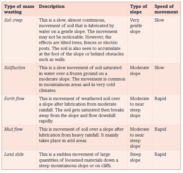
5.3.1 Forms of mass wasting
The movement of materials during mass wasting may be slow or rapid.
5.3.2 Causes of mass wasting
The movement of weathered materials down slope depends on:
• The weight of the weathered materials
• Earth or tectonic movements
• Nature of the material
• The angle of slope• Human activities
• Vegetation
Activity 5.4
In groups of five, discuss each cause of mass wasting mentioned above. Use various geographical materials and the Internet in your search for explanation.
Support your explanation with illustrations and photographs obtained from the Internet or newspapers.
Present your report to the class.
5.3.3 Effects of mass wasting
The effects of mass wasting are both positive and negative.
Activity 5.5
In pairs:
1. Read the following effects of mass wasting and classify each as either positive or negative.
• Mass wasting causes fertile soils to move down slope. This promotes crop farming down slope.
• Areas upslope that loose the fertile soils due to mass wasting loose fertility making them unsuitable for crop farming.
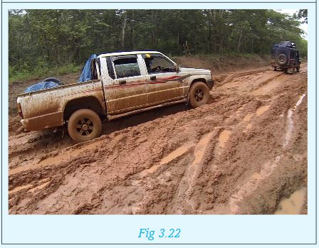
• Rapid mass wasting may causes destruction of property, infrastructure and even death of animals and people.
• Mineral deposits that may be underground get exposed upslope in areas where mass wasting originates from.
• The materials that flow down slope may block roads. This prevents transport.
• Materials carried down slope may block river channels in river valleys. This can change the flow of rivers or form temporary dams.
• Areas upslope that experience mass wasting may be prone to erosion. This is because the top soil will have moved down slope, exposing the softer underlying soils.
2. Discuss other effects of mass wasting.
Present your findings to class.
5.3.4 Measures of controlling erosion and mass wasting
The various measures used to control erosion and mass wasting are called soil conservation methods.S
oil conservation is a responsibility of each one of us. However, the government plays an important role to support this initiative. For example, by:
• Choosing alternative sites for infrastructural development.
• Creating public awareness on the need to conserve the environment to avoid cases of erosion and mass wasting.
Activity 5.6
1. Carry out a field visit and observe the method used to prevent or control soil erosion. This may be one or a combination of the methods mentioned below.
a) Afforestation
b) Reafforestation
c) Agro-forestry
d) P lanting cover crops
e) Ploughing across the contours
f) Using soil embankments on slopes
2.Identify the ways through which the government is participating in soil conservation measures.
Prepare a report for class presentation.
END OF UNIT REVISION QUESTIONS
In your notebooks:
1. Define soil erosion.
2. Identify the agents of erosion.
3 .State different forms of weathering.
4. Discuss different forms of mass wasting.
5. Describe the causes of soil erosion and mass wasting.
6. Explain the measures of controlling erosion and mass wasting.
Unit 6: RELIEF IN RWANDA
Key unit competence
At the end of this unit, you should able to distinguish different forms of relief features of Rwanda and their relationship with human activitiesIntroduction
Rwanda is one of the fifty four independent countries of Africa. It is in the central part of the continent within the great lakes region.
6.1 General presentation of Rwanda
a) Location of Rwanda
Activity 6.1
1. Using the Atlas, draw a map of Rwanda. Indicating the neighbouring countries.
2. On the map, show the major latitudes and longitudes that pass through or near Rwanda.
3. Discuss the challenges that Rwanda faces as a landlocked country.
Rwanda is a small landlocked country located in the Great Lakes region of east and central Africa. The country lies between 1°04’ and 2°51’ latitude south of the Equator and between 28°53’ and 30°53’ longitude East of Greenwich Meridian. Rwanda’s northern neighbour is Uganda, to the south is Burundi, to the west is the Democratic Republic of Congo and to the east is Tanzania.
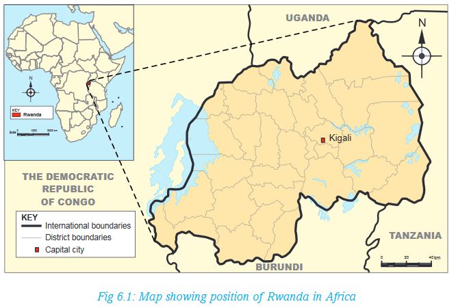
b) Size of Rwanda
Rwanda’s total area is about 26,338 square kilometres. The country is smaller than the neighbouring countries. It is the smallest country in Eastern and Central Africa. The water surface occupies about 1,668 square kilometres while the land surface is 24,670 square kilometres.
Activity 6.2
Using your atlas or information from the Internet:
i) Find out the sizes of Rwanda’s neighbouring countries.
ii) List their sizes in your notebooks. Start from the smallest to the largest. What is the last country on your list?
c) Administrative sub-division of Rwanda
Activity 6.3
1. Draw a map of Rwanda showing the districts and major towns in each district.
2. Find out the largest and the smallest district in Rwanda.
3.Draw a table showing where your home and school is, by completing the following chart:

Rwanda is sub-divided into thirty districts. The districts are found in five provinces.
The districts are further sub-divided into sectors, cells and villages.
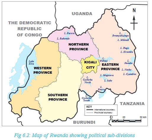
d) Population of Rwanda
Population refers to the number of people in a given area.
Dorothy has been having seven grandchildren. She has just seen her eighth grandson being born. Her third born son, Gahizi, got married fifteen months ago in a church wedding. Six of her eight children, including Gahizi, have completed school. Three of them already have formal employment. The other two are businessmen while the last born daughter just graduated from university. She remembers clearly when she was young. People used to have large families.
When her grandchildren visited her during the last holidays, she narrated to them how life was in the past. When she tried to compare to what it is now, she also got surprised. There are many people now, with not so much land to settle on. “People have increased to almost double since I was your age,” she once said during their evening story time.
Activity 6.4
1. From the above story, explain the reasons that have caused population increase.
2. In groups of four, use the Internet and other Geographical documents to:
a) Compare the total population of Rwanda as per the 2002 and 2012 census.
b) Explain possible factors that cause a difference in settlement in different parts of the country.
Today, Rwanda is estimated to have 11.5 million people. Many people live in the central part of the country. Here, the density ranges from 250 to 380 people per square kilometre. The density in the east and south west is less than 250 people per square kilometre.
Rwanda’s life expectancy in 2015 was 66.7 years for adults. For male population, the estimate is 65.2 years while for female population it is about 68.2 years. Interesting to note, however, is that the life expectancy of a Rwandan rose from 51 years in 2002 to 66.7 years in 2015.
Source: National Institute of Statistics of Rwanda, 2016
6.2 Rwanda, a landlocked country
Definition
A country is landlocked when it is surrounded on all sides by a country or countries and therefore has no direct access to a coastline. To access the coast of the nearest oceans, people from the landlocked country have to pass through other countries.
Activity 6.5
1.Using an Atlas, list all landlocked countries in Africa.
2.Use Internet search to find out three countries landlocked by a single country.
Disadvantages of being land locked
Activity 6.6
Read the following passage on the disadvantages of a country being landlocked. Afterwards, answer the questions that follows.
Historically, being landlocked has been disadvantageous to a country’s development. It cuts a nation off from such important sea resources as fishing. It also impedes or prevents direct access to sea trade. It is because of this reason that coastal regions are mostly wealthier than other areas inland. These areas are also more heavily populated than inland ones.
Landlocked developing countries have significantly higher costs of international cargo transportation compared to coastal developing countries.
Due to their remoteness, landlocked countries are dependent on neighbouring transit countries for their external trade and suffer from high trade transaction costs. Huge transport costs, inadequate infrastructure and challenges associated with importation and exportation requirements can be a serious hindrances to their integration into the global economy, impairing export competitiveness or the inflow of foreign investment.
Source: Wikipedia
From the passage above:
1. Discuss the disadvantages of a country being landlocked.
2. In groups of five, discuss whether the following statement is true or not.
Choose one of you to present your findings to the class.
Possible solutions of being land locked
a) Rwanda has made agreements on getting lower transport charges for goods through neighbour countries.
b) The United Nations has a law that protects landlocked countries from high taxation. The law gives these countries a right of access to and from the sea without taxation of traffic through transit states.
c) Rwanda is improving the quality of roads, which is part of Vision 2020. In partnership with neighbouring countries, Rwanda is expected to directly benefit from the Northern Corridor. This is the busiest and most important route in east and central Africa. It provides a gateway through Kenya to the landlocked economies of Uganda, Rwanda, Burundi and eastern Democratic Republic of Congo. It also serves South Sudan.
d) The government is improving energy supply and Internet access to improve the flow of information.
e) There has been efforts to reduce the time it takes to travel along the main roads to enable goods to move between 300km and 400km in a 24-hour period.
f) Landlocked countries like Rwanda depend on good political relations with transit countries. If a landlocked country and its transit neighbour are in conflict, the transit neighbour can easily block borders or adopt regulatory impediments to trade. Even when there is no direct conflict, landlocked countries are at a disadvantage due to the political problems of their neighbours.
6.3 The major forms of relief in Rwanda
Activity 6.7
1. List some of the relief features in Rwanda.
2. Draw an outline the map of Rwanda. On it, show the relief regions you have mentioned in the question above. Make sure that the sketch map has all the qualities of a good map, that is, the key, frame, title, compass direction and scale.
Relief is the general appearance or the nature of the landscape. The Rwandan relief is hilly and mountainuous with an altitude varying between 900 metres and 4,507 metres above sea level. In general, there are five major forms of relief that can be shown on the relief map of Rwanda. These are:
a) The mountainuous region
b) The plateau region
c) The plains region
d) The Rift Valley region
e) The Congo-Nile Peak region
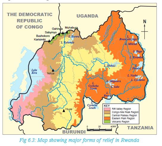
Each of these regions is discussed below:
(a) The volcanic region – This region lies above 3,000 metres above sea level. The highest altitude is 4,507 metres above sea level, which is the peak of Mt Karisimbi. The region is dominated by mountains of volcanic origin, including Karisimbi, Muhabura, Bushokoro, Gahinga and Sabyinyo.Due to its high altitude, it experiences cool and wet climate. The soils, which are of volcanic origin, are usually fertile. These factors have greatly contributed to settlement and various agricultural activities in the region.
(b) The plateau region – It consists of gently sloping hills and long u-shaped valleys. Its altitude ranges between 1,500 metres and 2,000 metres above sea level. The region stretches as far north as Gicumbi and as far south as Huye.
(c) The plains region – Also called the Eastern Savanna, the region is found farther east from the Central Plateau. Its altitude averages 1,280 metres above sea level. Rusizi Plain and areas around Lake Kivu are also on a plain. Bugarama is the lowest part of the country, and is in this region, at a height of approximately 900 metres above sea level.
(d) The Rift Valley region - This region lies on the western border of the country. It is also known as the Albertine Rift valley region. The region is part of the western branch of the Great Rift Valley which runs from the Middle East to southern Africa. It is part of the tectonic depression of the African Rift Valley.
(e) The Congo-Nile Peak region - This is a region found in the west of Rwanda. It lies between 2,500 m and 3,000 m above sea level. The region crosses the rift valley along the line of the Virunga Mountains to the north of Lake Kivu. It creates a divide between the waters of Nile River and the waters of the River Congo. Rivers flowing to the west form the tributaries of the Congo River while rivers flowing east enter Lake Victoria and the Nile River.
Activity 6.8
Identify the provinces in Rwanda where the above mentioned relief features are found.
Did you know?
In 1992, the Volcanoes National Park, which is found in the volcanic region in Rwanda, became a battlefield during the Rwandan Liberation War, with the park headquarters being attacked and the research centre was abandoned. This led to the stopping of all tourist activities including visiting the gorillas. Tourism activities were resumed in July 1999 when the area was deemed to be safe and under control. Since then, the number of visitors traveling to the Birunga had greatly increased.
Advantages of relief features in Rwanda
Activity 6.9
Read the following story then answer the questions that follow:
In her Geography lesson, Ms Hakizimana of Kagarama School was to teach about advantages and disadvantages of relief features in Rwanda. She took the learners under a tree where she started by saying:“Farming takes place in highland areas, though it should carefully be done to avoid soil erosion and degradation. This is why terracing is done in such areas to prevent the loss of the fertile top soil,” she said.
She then asked her learners to describe human activities in the areas where they come from. The following were the learners’ responses:
Kamagaju: Our home is on the plains that border Nyabarongo River. Here, people cultivate crops because they say the soil is deep and fertile.
Ngoga: I come from Karongi District, near Lake Kivu. Some people around the lake practice mining near the beaches because the area has alluvial minerals.
Kabano: Roads to our rural home in Gicumbi goes around some of the hills they are constructed on. Due to this, motor taxis say driving fast on such roads is dangerous.
Ntawizerakundi: I have grown up in Kigali. I have friends in Kiyovu, Nyarutarama, Rebero and Kacyiru. Sometimes, I visit them. I believe people are settled in these places because Kigali and its surrounding areas are on gentle slopes.
Gasaro: I saw Rwanda Telecommunication service vans climbing the hills near our home to repair the communication masts on Kagarama hills. One of them was overheard saying that they were to proceed to the station on Mt Karisimbi afterwards, before going back to the office.
Teta: My uncle, a lecturer at the University of Rwanda, once told me that there are no settlements on the slopes found in places such as Sabyinyo, Karisimbi, Bisoke, Gahinga and Muhabura.
Cyubahiro: My guardian is an agricultural extension officer. She told me that on the leeward slopes of the places Teta has mentioned are unsuitable for crop farming.
Mugisha: The water we use at home comes from the water tanks mounted on a nearby hill. The water is also used throughout our district. It is said that these tanks, which are on a hilltop, supply water to the district using natural gravity.
Mwiza: The road constructed on the plains where Kigali International Airport was built passes near our home.
Nziza: Poor farming methods in our neighbourhood in Rusizi caused soil erosion. This is because the land is hilly. However, people practice contour farming nowadays to prevent further loss of fertile top soil.
From the discussion above, mention both the advantages and disadvantages of relief in Rwanda.
Remember!
Farming on the slopes can easily trigger soil erosion. It is therefore important that farmers engage in modern methods of farming that promote continued use of the soil. This can be achieved through ploughing across the contours. This is one of the sustainable farming methods, which is a way of conserving the environment.
Disadvantages of relief features in Rwanda
a) Building roads, railways, electricity lines, data cables and coming up with different forms of infrastructure on sloping land is expensive. This is because the land needs to be flattened before construction. Roads constructed on steep slopes are winding in nature. Such areas include Kabale.
b) Inappropriate farming methods on hillsides and mountain slopes can trigger soil erosion, causing loss of the fertile top soil. Landslides and are also a potential risk in slopy areas.
c) Thick vegetation on the sides of some hilly and mountainous areas discourages settlement. For instance, there is no human settlement on the slopes of mounts Sabyinyo, Karisimbi, Bisoke, Gahinga and Muhabura.
d) The low temperatures experienced on some of the mountains such as Sabyinyo, Karisimbi, Bisoke, Gahinga and Muhabura make human habitation impossible. On the other hand, the leeward sides of the mountains are unsuitable for crop farming. These areas experience low temperatures and rainfall respectively.
6.4 Relationship between relief and human activities (Land use in Rwanda)
Relief determines the way people make use of that land.
Activity 6.10
In groups, use maps, geographic information and the Internet to find out the human activities in Rwanda.
What is the relationship between the human activities and relief?
Mountain slopes and hillsides are set aside for forestry and for conservation of wildlife. An example is the Birunga National Park. This promotes tourism. Where natural forests have been cleared, for example in Gishwati forest, more trees have been planted as a form of environmental conservation.
On the other hand, farming takes place on broad valleys such as Nyabarongo (sugarcane), Nyacyonga (rice) and Akanyaru in Gisagara and generally in Kigali where vegetables and rice are grown.
In most cases, people avoid land that has steep slopes because it is not suitable to establish settlements, farms or roads and railways. Steep land is only used if people have no other areas to make use of. For instance, in some parts of Rwanda, people have farms that are on hillsides because the land is hilly. They farm using contour method to avoid soil erosion. Crops like tea is grown on sloping land where soil is well drained.
Adapted from Rwanda State of Environment and Outlook Report (2009) - By REMA
The photograph below shows farms on a hilly area in Rwanda.
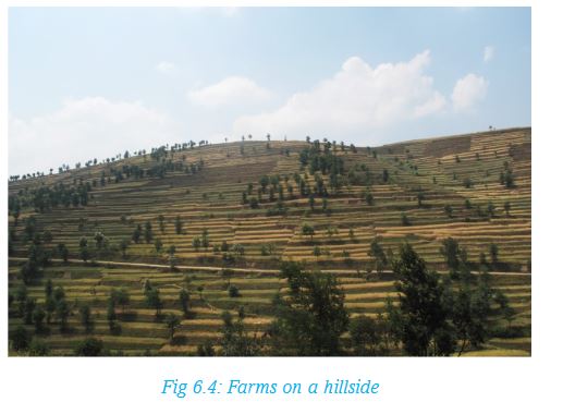
Building houses on sloping land is also expensive because one has to make some flat surface where the house will stand. There are many settlements on hillsides in Rwanda. It is also very expensive to build roads on land that is steep.
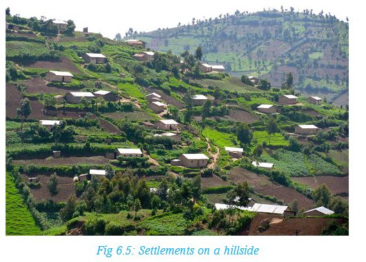
Remember!
Human activities such as farming and settlements are more common on land that is gently sloping or flat because it is easy to set them up. Steep mountains and hillsides are set aside for forestry and for conservation of wildlife. Where natural forests have been cleared, more trees have been planted as a form of environmental conservation. Such areas include Gishwati Forest, whose forest cover has been restored after extensive deforestation in earlier years.
END OF UNIT REVISION EXERCISE
1. What is the meaning of the term ‘relief’?
2. What are some of the relief features in Rwanda?
3. On what type of relief do people practice contour farming and why? Give examples of such areas in Rwanda.
Unit 7: WEATHERING AND ROCKS
Key unit competence
At the end of this unit, you should be able to distinguish between different types of weathering and their relationship with rocks.Activity 7.1
Uncle, where are the rocks?
Sonia recently visited her uncle in Musanze. There used to be many rocks near her uncle’s home.
“Where are the rocks, uncle,” she asked.
Her uncle answered, “The tarmac road needs to be expanded. Large tractors have been leveling the land to enable this.”
“Last week, they were crashing some stones that were on the way,” he continued.
“Uncle, is it true that the foundation of this house was made using some of the stones?”, she asked.
“Yes Sonia,” his uncle replied. “However, we call it gravel, which was mixed with cement and sand. We got the gravel from the nearby quarry,” explained.
“By the way, many of the rocks you see now were very large in the past. Some people say they are slowly sinking. They have really reduced in size!” he exclaimed.
1. Using the story above, explain what caused the disappearance of the rocks.
2. Explain what may have caused the reduction in the size of the rocks.
From the story above, you will realise that the physical environment changes with time. This may be caused by human activities. It can also be caused by natural processes.
For you to find out
From the knowledge gained from the study of weathering in Unit 5, define the term weathering.
One of the natural processes that causes changes in the environment is weathering.This is because weathering is the process in which rocks break down or decompose near the earth’s surface. The rocks break or disintegrate in situ (that is, the particles do not move from their original position). This is the reason why Sonia’s uncle said they rocks were thought to be sinking. This is because after weathering, the rock materials accumulate around the rock they break from.
The process of weathering may be caused by the exposure of rocks to elements such as temperature changes, rain or human activities. These elements are called agents of weathering.
Activity 7.2
1. From Sonia’s story, identify the main agent of weathering mentioned. Give reasons for your answer.
2. In groups of five, find out how the following elements may be agents of weathering:
• Wind
• Large and small animals
• Plants
7.1 Types of weathering and resultant features
There are three types of weathering. These are:
• Physical weathering
• Chemical weathering
• Biological weathering
a) Physical weathering
This is the breakdown of a rock into smaller fragments, with its mineral or chemical composition remaining the same. Physical weathering is also called mechanical weathering.
The main agent of weathering in physical weathering is temperature.
The main types of physical weathering are:
(i) Exfoliation
(ii) Block disintegration
(iii) Granular disintegration
(iv) Pressure release
(v) Frost action
(vi) Rainwater action
i) Exfoliation
This is the peeling off of a rock surface due to alternate expansion and contraction of the outer layer.
Activity 7.3
In pairs, research about how the process of rock exfoliation takes place from various geographical documents and the Internet. Use an onion to explain your findings.
Photographs such as the one shown below can also be helpful.
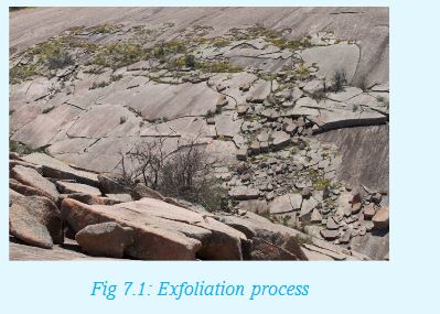
ii) Block disintegration
Block disintegration is experienced in areas which experience high temperature during the day and low temperature at night.During the day, the rock gets heated causing it to expand.
During the night, when temperatures fall, the rock cools and contracts. If this process continues for several days, the rock develops cracks. It then breaks from the main rock.Evidence that this type of weathering has taken place is presence of large blocks of rocks over or near the original rock.

iii) Granular disintegration
This occurs to rocks that have different chemical composition. The contraction and expansion of a rock due to temperature changes causes the rock to break. Such rocks break into small grains of individual mineral components of the rock. This is because each mineral has its rate of expansion and contraction. This process is evidenced by presence of numerous small stones spread over the original rock.
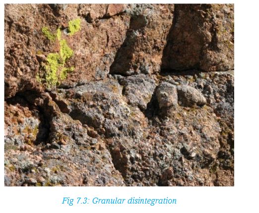
iv) Pressure release
This type of physical weathering is also called loading. Rocks that lie deep underground are under great pressure exerted by the rocks, soils and any other materials piled above them. Removal of these overlying material through processes such as erosion is like removing a load from the rocks that are underneath. Removal of the weight causes the underlying rocks to relax which leads to cracking especially on the upper layers of the rock. The cracked layer slowly wears away. The process is repeated on the next exposed layer
v) Frost action
This is the action of ice on rocks. It occurs due to repeated freezing and thawing of ice that has accumulated in cracks of rocks. This caused the cracks to gradually expand and eventually individual pieces of rock disengage from the original rock. The broken pieces of rock have sharp edges. This weathering process is common on the high mountains at the snow line where freezing and thawing occurs. In Rwanda this is evidence on the slopes of Karisimbi at the snowline.
vi) Rain water action (slaking)
This process is also known as slacking. It is common in areas that have distinct wet and dry seasons and where rocks contain high amounts of clay. During the wet season, clay absorbs moisture causing it to swell. During the dry season, clay loses water and shrinks. If the swelling and shrinking continues over a long time, individual grains of the rock break off and get detached from the original rock and from each other. Rainwater can also dissolve minerals that bind rocks together. This weakens the rock which then breaks down into fragments.
b) Chemical weathering
Chemical weathering occurs when some or all of the mineral constituents in a rock decompose. This causes the rock to break down, fall apart or disintegrate. Chemical weathering involves chemical reactions between the rock’s minerals and water. Sometimes, atmospheric gases also play a role in the decomposition.
Chemical weathering mainly occurs in areas with high temperatures and high humidity.
Chemical weathering occurs in the following ways:
a) Hydrolysis
b) Oxidation
c) Solution
d) Carbonation
e) Hydration
Each of these terms is as explained below.
(a) Hydrolysis
This is a reaction between the hydrogen ions in water and the ions in the mineral. This reaction breaks down. The best example is the decomposition of feldspar rocks to form clay. Hydrolysis is common in rocks that contain silica. This process is common in the weathering of granite.
(b) Oxidation
Oxidation is where rocks containing iron compounds come into contact with oxygen to form iron oxide. Rocks which contain iron, when exposed to water or oxygen, readily breaks down to form iron oxides. The oxide is a brown crust which is usually seen on rocks that have undergone this process.
(c) Solution
This is a weathering process that affects rocks that have minerals that can dissolve in water. When these rocks come into contact with water, the soluble minerals dissolve, causing the rocks to crumble.
(d) Carbonation
This is where water combines with carbon dioxide to form weak carbonic acid that reacts with rocks. These are rocks that mainly have calcium or magnesium minerals such as limestone. The acid removes the mineral in solution, leaving the insoluble rock residues.
(e) Hydration
This involves the absorption of water by the minerals contained in the rock. The rock minerals then expand, causing stress to develop within the rock. This ends up crumbling the rock.
NOTE: All the processes of chemical weathering are closely interrelated and depend on one another. These processes break down the rock by:
• Converting the original minerals to newer minerals that are easily removable.
• Weakening the bonds within the rock by removing what cements the rock together. This breaks down the rock.
c) Biological weathering
This type of weathering is due to the action of living organisms on rocks. People, plants and animals can act to cause the breakup of rocks.
Activity 7.4
In pairs, explain how the following living activities can cause biological weathering:
i) The penetration of plant roots into cracks in the rocks.
ii) Activities of burrowing animals such as moles and squirrels.
iii) Action of worms which mix the soil from time to time.
iv) Hoofed animals which walk and run on rocks.
v) Human activities such as quarrying, digging and mining.
7.2 Factors influencing weathering
These are things that either promote or prevent weathering from taking place. These factors include:
• Climate
• Rock types
• Vegetation
• Relief
Activity 7.5
In groups of five, research on how each of the above mentioned factors can influence weathering. Use the following hints in your explanation.
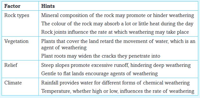
7.3 Relationship between weathering and different rock types
Different rock types have different structures. It is these structures that determine the rate of weathering. The structure can be explained in terms of:
i) Rock permeability
ii) Mineral composition
iii) Joints in the rock
iv) Rock pH
v) Colour of the rock
Rock permeability: This is the ability of a rock to absorb water. Rocks with limestone promote rain percolation. This causes decomposition of rocks due to its reaction with water. Where permeable rocks alternate with impermeable rocks, weathering by solution method occurs on dissolvable parts of the rock. This leaves some parts of the rock intact as other parts are ‘eaten’ away.
Mineral composition: Rocks with uniform minerals expand and contract at the same rate. This may result into exfoliation due to the peeling off of the outer layers uniformly.
Rocks with iron on the other hand can easily be weathered by oxidation while those containing limestone can be weathered by carbonation.
Rocks with different minerals get weathered differently. The minerals may have different abilities to absorb water or heat. This causes them to disintegrate at different rates.
Rock joints: Unjointed rocks are difficult to be weathered as neither water nor plant roots can penetrate them easily. This is unlike jointed rocks which allow water and plant roots as well as small animals to pass through them.
Rock pH: Acidic rocks are more resistant to weathering than other rocks. However, such rocks easily undergo physical weathering. An example is a rock made up of granite. Alkaline rocks on the other hand are easily weathered chemically but are resistant to physical weathering. An example is basalt.
Colour of the rock: The type of mineral determines its colour as well. Some minerals are dark coloured than others. An example of such a mineral composition is Augite. Rocks with such minerals tend to absorb heat faster than those which are generally bright coloured, such as olivine. This makes them to be easily weathered through block disintegration.
END OF UNIT REVISION EXERCISE
In groups:
1. State and explain different types of weathering.
2. Explain the factors that influence weathering.
3. Determine the relationship that exists between weathering and rock types.
Unit 8: SOILS IN RWANDA
Key unit competence
At the end of this unit, you should be able to appreciate the measures of soil conservation and soil control in Rwanda.Introduction
Soil is the top layer of loose materials that lies on top of the crustal rocks. Soils form after weathering of the parent rock into small particles. The soils are made up of gases, water, mineral matter, remains of plant and living organisms. It is therefore important to learn about soil so that we can protect it for future generations.
8.1 Types of soils in Rwanda
1.Kaolisols
They form the main type of soils in Rwanda. These soils developed on weathered parent material which mainly had clay mixed with iron and aluminium oxides. They appear reddish due to the presence of iron and aluminium oxides. The profile of kaolisols reveals an upper humus horizon of low humus while the structure of the middle section differs for different subtypes, but it generally shifts gradually from the humus horizon to the parent rock. Kaolisols are found in the central area of Rwanda. They are usually deep.
In Rwanda, these soils are further divided into xerokaolisols and humus-bearing kaolisols.
a) Xerokaolisols are characterised by a thin layer of humus. Beneath the humus lies a layer resulting from the accumulation and cementation of iron and aluminium oxides thicker than the humus layer. Patches of xerokaolisols are witnessed stretching from the central part of Rwanda, though they become more prevalent as one moves towards the eastern part.
b) Humus-bearing kaolisols are largely composed of elements and compounds of aluminium, iron and, in smaller quantities, calcium, magnesium, sodium, and potassium. Factors determining the nature of these soils are vegetation type and climate. Other factors are parent rock material and geographic relief. Geologically young soils resemble their parent material more than older soils, which have been altered over time by climate and vegetation.
2. Valley Soils
These are mainly found along river valleys. They are mainly of alluvial origin. The two main categories of valley soils are vertisols and organosols (or histosols) and vertisols.
a) Vertisols have a high clay content and are often subject to marked shrinking and swelling with changes in water content. They are generally low in organic content. Vertisols typically form in climates that are seasonally humid or subject to periods of droughtsand floods or that impeded drainage. Depending on the parent material and the climate, they can range from grey or red to the more familiar deep “black cotton” soils. Areas with vertisols include those found in the lower parts of Nyabarongo River.
b) Organosols on the other hand refer to wet soils consisting mostly of high organic matter, popularly called peats and mucks. When they dry, they become hard and ends up cracking.
Organosols form whenever the rate of formation of organic matter is more rapid than its rate of destruction. This occurs because of restricteddrainage and a slow process of decomposition making the remains of plants and animals to remain within the soil. This makes organosols very importantbecause they store large quantities of organic materials. They are generally very difficult to cultivate because they are found in areas of poor drainage. However, organosols can often be very productive when drained. Areas with organosols include those found in Rugezi Swamps.
3. Highland soils or Inceptisols
Inceptisols form quickly through weathering of parent material under the influence of low temperatures and high temperatures. They are more developed than soils that do not show any profile development. They have no accumulation of clays,iron oxide,aluminium oxideor organic matter. Their geographic settings vary widely, but are mainly found in upland forest environments.
Inceptisols are found on the slopes of mountains in the north west of Rwanda, covering most parts of the Congo-Nile peak. They also form a larger part of the soils in the Birunga slopes.
4. Volcanic soils
As their name implies, this grouping of soils is found only on volcanic parent materials. These soils are usually the dominant soil in young volcanic landscapes. This is because of the unique combination of soil properties that result from the weathering of volcanic rocks. Only under strong tropical weathering will lavas weather to finer grained volcanic soils, so it is usually parent materials of a volcaniclastic origin which result in the high-producing volcanic soils in Rwanda.
Many volcanic soils have excellent physical properties that make them highly desirable for a wide range of uses. Generally, these soils are among the most fertile lands in the world and are, therefore, very intensively cultivated
Rwanda’s volcanic soils are fertile although periodic drought, soil erosion and soil exhaustion through over-cultivation on small family plots has led to food insecurity in some parts.
In Rwanda, with the highest population densities in Africa, volcanic soils cover 700 km2, providing a vital food resource. Cultivated crops here include maize, sorghum, potatoes, pyrethrum, and peas, along with bamboo and eucalypts.
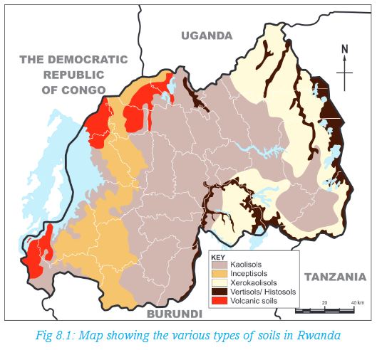
Activity 8.1
1.In pairs, study the map showing distribution of soils in Rwanda.
2.List all the types of soils shown.
3.Use your atlas to identify the provinces where these soils are found.
(a) Which provinces share the same type of soils?
(b) Which type of soil covers a larger area in Rwanda?
Soils differ in colour, size of grain particles, the pore spaces and amount of water the soil can hold. All these are referred to as soil characteristics. The activity that follows will help you to learn more about the soil characteristics.
Activity 8.2
Purpose
To find out soil characteristics
Inquiry
What are the characteristics of soil?
Materials needed
• 2 containers/Beaker
• Water
• A handful sample of soil
Procedure
1.Make a copy of the table below to guide your observations.
2.in g roups, examine the soil sample carefully and record your findings.
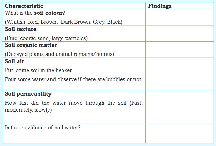
Share the differences and similarities of soil characteristics observed by your classmates.
Activity 8.3
In pairs, look at the following photographs showing different types of soils.

In pairs, look at the photographs of different types of soils shown above.
With reasons, identify each type of soil shown.
8.2 Soil erosion and impoverishment in Rwanda
Activity 8.4
In pairs, answer the following questions:
1. From the knowledge gained in Unit 5, give the meaning of soil erosion.
2. Use the dictionary, atlas and the Internet to get the meaning of soil impoverishment.
3. Explain the main difference between soil erosion and soil impoverishment.
Soil erosion is the physical removal of topsoil by various agents. These agents includerain, water flowing over land through the soil profile, wind, ice or gravitational pull. It also means the process by which soil is removed from a place by human activities such as construction and farming. The soils are eventually deposited at a new place
Soil erosion and impoverishment may be caused by natural events such as heavy rainfall or drought particularly in areas that receive low rainfall. The impoverishment of the soil may be caused by natural events or by human activities such as poor methods of agriculture. The damage on soil may have long lasting effects on land, people and their way of life.
(a) Causes and effects of soil erosion in Rwanda
There are several reasons why soil erosion happens in a given area. It is either caused by natural events or it is human induced.
Activity 8.5
In groups of four, revisit Unit 5 on the section about causes of soil erosion on landscape.Make brief notes on how the following factors cause soil erosion.
• Influence of climate
• Shape of the landscape
• Removal of plants cover
• Human activities
Prepare a report for class presentation.
Did you know?
During the liberation war in 1994, many people sought refuge in the forests. This increased pressure on land. It also led to excessive cutting of trees for fuel.
(b)Farming practices that lead to soil erosion
i. Where plots are cleared and later abandoned makes them open to agents of erosion.
ii. Ploughing of land in the wrong way that is, up and down the slope results into formation of channels that are gradually enlarged by water erosion to form gullies.
iii. Farming of the same type of crop or mono- cropping reduces important soil nutrients. This weakens the soils making it prone to wind and soil erosion.
iv. Cultivating crops in areas of unpredictable rainfall makes the soil lose during the dry season exposing it to wind erosion.
v. Overgrazing of pasture particularly by domestic animals destroys the vegetation cover exposing the soil to erosion.
vi. Other human activities such as mining, quarrying, road construction make the soil susceptible.
(c) Effects of soil erosion
Activity 8.6
In pairs, discuss the effects of soil erosion in the community where the school is located.Present your findings for class discussion.(d)Effects of soil erosion
i) Soil erosion in parts of Rwanda has made a larger part of the land infertile. This has lowered farm productivity and is a great loss to farmer’s earning and government revenue. There is also rise in poverty.
ii) Soil erosion has led to loss of arable land and spread of aridity.
iii) With the deterioration of land, the farmers are forced to migrate to make a living in other places.
iv) When soil erosion sets in, the vegetation and other important organisms are lost. In turn, the land becomes furrowed with gullies. This makes it to lose its natural beauty.
v) The soil washed by surface flow is deposited in the streams which causes water pollution. This also causes siltation.
vi) Absence of vegetation cover increases chances of flooding.
8.3 Soil conservation methods in Rwanda
You learnt that the soil is an important natural resource. This is because it supports almost all human activities. However, soil is a non-renewable resource because the rate of soil loss through erosion is faster than its rate of formation. Soil should therefore be effectively conserved for it to remain productive.
Soil conservation measures are the careful decisions and practices taken to protect land from erosion. The soil conservation practices are aimed at helping minimise soil loss. These measures are also aimed at rehabilitating waste lands to usable lands for cultivation. The measures include:
a) Crop rotation
b) Use of fertilisers
c) Planting cover crops
d) Mulching
e) Contour ploughing
f) Planting trees
g) Strip cropping
h) Controlled grazing
i) Terracing of land
j) Creating wind breakers
Activity 8.7
In groups of four:
1. Study the photographs below carefully. Explain the method of soil conservation being used in each photograph.
2. With reasons, identify the conservation method used in your local environment.
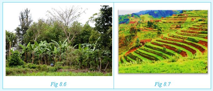
Each of the method of soil conservation is explained below:
a) Crop rotation
What is crop rotation?
This is the practice of growing different crops at different times on the same piece of land. In contrast, mono-cropping is the continuous cultivation of a single crop on the same piece of land. This impoverishes the soils.
The practice of crop rotation keeps the topsoil covered with plants. Rotation of cereal crops with legumes also keeps the soil enriched with nitrogen (from the legumes). This ensures the maintenance of soil fertility and reduces the possibility of soil erosion.
b) Use of fertilisers
Fertile soil supports a variety of farming practices. Loss of fertility results in decline in productivity. Fertility of soil can be restored by addition of manure or fertilisers.
c) Planting cover crops
Cover crops include the grasses and small grains which form dense cover crop stands. These crops may also include cow peas and beans (collectively called legumes). They help slow down the speed of rain drops before hitting the soil surface. They also prevent surface runoff, which may cause erosion.
d) Mulching
Mulching involves covering the soil with crop remains, grass or artificial materials such as polythene sheets. The purpose is to reduce loss of soil moisture. Mulching also reduces soil erosion by running water. With the decomposition of plant remains, humus is formed and improves soil fertility.
e) Contour ploughing
In this system of cultivation, the ploughing is aligned to the contours. The furrows in contour ploughing help to trap the soil and reduce soil erosion by surface runoff. This way, the soils are able to retain water.
f) Planting trees
Activity 8.8
For you to find out!
a) Which method of soil conservation is shown in the photograph? Give a reason for your answer.
b) Explain the difference between afforestation and reafforestation.
You may have noticed the bad effects of heavy rain mostly on bare ground. To reduce that negative effect, it is important to plant trees. They prevent rain splash erosionby protecting the soil from the direct impact of water droplets. The trees also reduce the amount and speed of surface runoff by improving the rate of water absorption. The decayed plant remains from the trees become humus which increases soil fertility.
g) Strip cropping
Strip cropping involves growing of crops in alternate bands. The strips of crop are planted at right angles to the slope. The strips of crop may also be planted at right angles to the direction of wind to limit wind erosion.Strip cropping reduces the speed of surface runoff. The roots of these crops also hold soil particles together. This prevents soil erosion.
h) Controlled grazing
Large herds of domestic animals such as cattle, sheep and goats graze and expose the topsoil to erosion. Thus, the land should be protected from overgrazing. Farmers are encouraging to control the numbers of their stock to avoid overgrazing.
i) Terracing of land
In this system of cultivation, terraces are cut at right angles to the slope. This slows down the flowing water and reduces soil erosion. In places with deep gullies, barrier terraces are constructed to protect such land. Grasses can also be planted on the slopes to form protective bunds.
j) Creating wind breakers
These are shelter belts whereby trees are planted across the wind direction to protect against the high velocity winds. These rows of trees are wind breaks or wind barriers. They help to control wind erosion.
END OF UNIT REVISION EXERCISE
1. Write brief notes on the three constituents of soil.
2. How does heavy rain cause soil impoverishment?
3. Herbert has a small farm on which he practices mixed farming. Lately, the productivity has gone down.
a) What are some of the probable causes of the declining farm productivity?
b) Suggest appropriate solutions that Herbert could apply to improve soil quality.
4. How does Rwanda stand to benefit from soil conservation?
Unit 9: CLIMATE AND CLIMATE CHANGE IN RWANDA
Key unit competence
At the end of this unit, you should be able to analyse the climate of Rwanda and how climate change has impacted on it. Compare and contrast the impacts on Rwanda with other countries.Introduction
The Republic of Rwanda, also known as “the Land of a Thousand Hills”, boasts of moderate temperatures and ample rainfall throughout the year. A notable difference in the prevailing climatic condition is also attributed to the presence of Lake Kivu on the western part of the country. For instance, it’s rainy in the northern and western parts of the country, more being received in the forested areas. The eastern parts tend to be drier than any other part of the country. The country experiences moderate daytime temperatures in the lower mountains, much cooler temperatures on the higher mountains, with nighttime temperatures being moderate.Climate influences the various human activities people engage in. For instance, the drier areas in the eastern and south eastern regions such as Nyagatare, Ngoma, Kirehe, Busegera and Mayaga favour pastoralism while the wetter areas in the northern and western parts such as Musanze, Rubavu, Nyamagabe and Gicumbi are good for crop farming. The forested areas such as Nyungwe on the other hand promote tourism.9.1 Climatic regions and seasons in Rwanda
Activity 9.1
In groups of five:
1. Discuss the differentiate between weather and climate.
2. Identify six elements of weather and give the name of instruments used to measure each of them.
Climate is the average weather conditions of an area recorded over a long period of time. This period may range between 30 and 35 years.
Activity 9.2
Use your dictionary, the Internet and other geographical documents to differentiate between the terms ‘climate’ and ‘seasons’. Write your findings in your notebook. Share your findings with your classmate.
9.1.1 Major climatic regions of Rwanda
The climatic regions in Rwanda can generally be categorised as follows:
a) Tropical wet Lake Kivu
b) Tropical wet-dry central plateau
c) Tropical wet-dry lowlands
d) Temperate tropical highland
Activity 9.3
Look at the map of Rwanda shown below. It shows the two various climatic regions in our country.
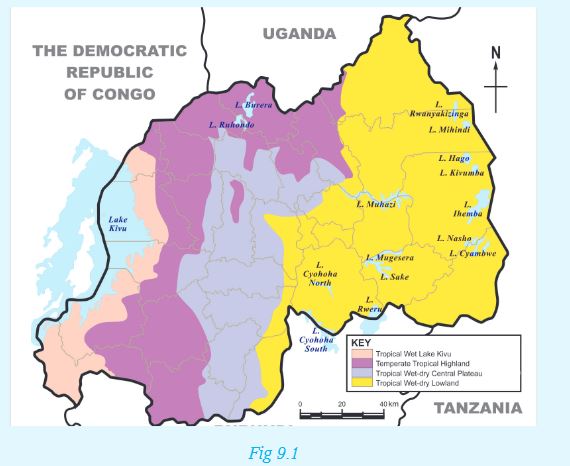
1. In groups of five, use an atlas showing administrative regions to identify the provinces where each climatic region is found. Share your findings with the class.
2. From the map above, which type of climate is experienced in your local area?
Tropical wet Lake Kivu
In this region, average annual rainfall levels range between 1300 mm (Lake Kivu) to 2000 mm (Nyungwe and Volcanoes). Rainfall is received all year round, though you will find the area wrongly referred to as experiencing a double rainy season. This is because it has two rainfall seasons where the average received is higher than all the other months.
Temperatures depend on altitude and levels of humidity, with Lake Kivu experiencing an average of 250C, Nyungwe cooler at 15.50C and Volcanoes being colder at 9.50C. However, rainforest temperature, for example in the Nyungwe forest, can rise to up to 300C. Moving east, the altitude drops, and the climate is much more clearly dry-wet tropical (semi-arid). Temperatures range between 240C and 280C and average rainfall levels fall to between 750mm (Akagera National Park) and 1000mm (Kigali).
Tropical wet-dry central plateau
Areas within the high altitude of between 1500m and 2000m above sea level especially in the central plateau, accounts for its tropical highland climate. Daily temperatures typically range as much as 250C. The sun shines nearly all year round, and, whatever the season, the mean daily temperature is close to 24°C. Most of the country has minimum night temperatures of around 10°C and maximum daytime temperatures of around 300C.
The central plateau has moderate rain. Rainfall is between 1000 mm and 1200 mm. Areas in Rwanda that experience this type of climatic conditions include Huye, Muhanga and Rubona.
Tropical wet-dry lowlands
In this region, climate is very hot and fairly dry. The average annual temperature is between 200C and 220C. Some areas, for example those near Gabiro, which are at an altitude of about 1480m above sea level experience a temperature of about 210C.
The sky is less cloudy and the area receives little rainfall, sometimes going as low as 1000 mm per year. Areas such as Gabiro and Karama receive approximately 830 mm and 850mm of rainfall per year respectively.
Temperate tropical highland
Areas that receive this type of rainfall are mainly found in the western and northern highland region (the Congo-Nile peak and Birunga region). They lie generally between 1800 m and 3000 m above sea level.
These areas are generally humid with the annual temperatures becoming cooler as the altitude increases. Temperatures experienced range between 150C and 170C. Climatic conditions of these characterstics are experienced in areas such as Musanze, which lies at 1860 m above sea level and Gisovu, at 2300m above sea level. The two areas experience an average of 18oC and 15oC respectively.
Rainfall is abundant and always above 1200 m. For example, Musanze, at 1860 m of altitude receive about 1300 mm of rainfall while Mata (Nyaruguru), at 1900 m of altitude receive 1575 mm of rainfall.
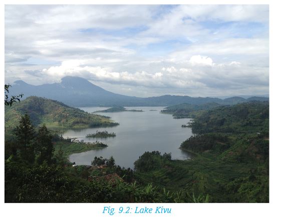
9.1.2 Types of seasons in Rwanda
There are two major seasons in Rwanda. These are the rainy season and the dry season.The long dry season starts from June to mid-September. From mid September to mid December is a short rainy season. This season is followed by a short dry season from mid December to mid February. However, there is a long rainy season between mid February and May.
Remember!
In Rwanda, seasons are broadly classified as dry or rainy. These seasons do not follow a certain trend (that is Winter, Spring, Summer and Autumn), as is the case with seasons in countries found in high latitudes such as America.
Activity 9.4
1. List in your notebooks the specific periods in terms of months of the year when Rwanda generally experiences a dry season and a wet season. Which months are seen as transitional months between one season to the other?
2. Identify and explain the various human activities that take place during the various seasons experienced in Rwanda. For example, before the rainy season, farmers usually prepare their farms for the next planting season.
9.2 The concept of climate change
Climate change is a large-scale, long-term shift in the weather patterns. For instance, the average temperatures over a large area of land may generally increase. Evidence of climate change may be in terms of:
i) Temperature changes
ii) Changing rainfall patterns
iii) Changes in seasons
Activity 9.5
In groups, use geographical documents, textbooks and the internet to research and discuss about the concept of climate change in Rwanda. Write down the findings for class presentation.
Remember!
The Government of Rwanda, through the Green Growth and Climate Resilience Strategy, aims to deal directly with actions that directly lead to climate change. This is through actions such as:
• Reducing dependence on rain-fed agriculture.
• Seeking cheaper, better alternative sources of electricity.
• Reducing emissions into the atmosphere that pollute the environment.
• Protecting the environment against further destruction through various human activities.
9.3 Causes of climate change in Rwanda
a) Pollution
This is the contamination of air, soil, water and the environment in general. In other words, pollution is anything that makes the earth dirty and unhealthy.
Activity 9.6
1. In your notebooks, make notes on the four main types of pollution.
2. Research from the Internet and other geographical sources the concept of global warming. Use diagrams where possible.
Air pollution is the most rampant type of pollution in Rwanda. The main air pollutant is carbon dioxide, which is emitted from industries and motor vehicles exhaust fumes.
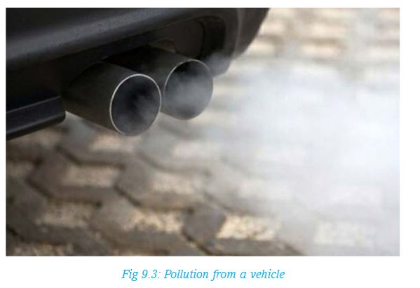
Air pollutants cause global warming by trapping heat from the sun in the earth’s atmosphere, causing a rise in temperature on the earth’s surface.
b) Human misuse of the environment
There are many types of human activities that directly cause changes in climate.
Activity 9.7
1.Look at the photograph below. Identify the activity taking place. Explain how such activities may contribute to climate change. Cite examples from the local environment.
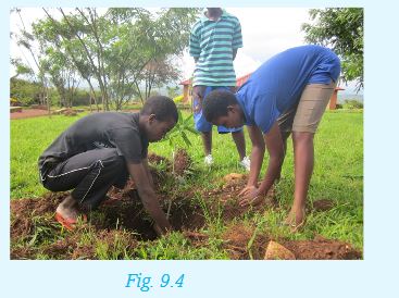
2.Explain how the following human activities contribute to climate change. In each case, state whether it promotes or destroys the environment.
• Deforestation
• Construction of dams or reservoirs
• Overstocking
• Growing crops such as rice under irrigation
Remember!
Human activities can alter the climate of a region either positively or negatively. In order to maintain a perfect balance in our environment, we should engage in activities that better our environment.
9.4 Effects of climate change in Rwanda
Changes in weather patterns over time have had a major effect on various human activities in Rwanda. These include farming, fishing, settlement, transport and even time to go for holidays.The following are some of the resultant effects of climate change in Rwanda:
a) Drought
b) Landslides
c) Floods
d) Aridity and desertification
Each of these effects is discussed below:
a) Drought
Drought is a long period of dry weather, when no rain falls for weeks or even months.
Activity 9.8
1.In groups, explain how the following factors have contributed to drought in Rwanda in the recent past:
i) Low rainfall totals
ii) Deforestation
iii) Overgrazing of animals
iv) Poor methods of farming like bush burning and monocropping
2.Describe how the factors above affected the livelihood of people, animals and the environment at large.
Drought has many effects, including the following:
• A shortage in the supply of water both for domestic and industrial use.
• Loss of livestock to starvation due to lack of pasture.
• Reduced hydro-electric power generation due to reduced water levels in rivers.
• Reduced food production as a result of less rain and little water in the rivers to support crop cultivation.
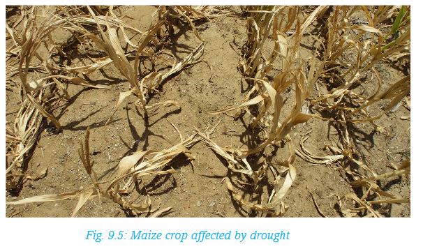
• Drying up of pasture lands, making them vulnerable to fire outbreaks.
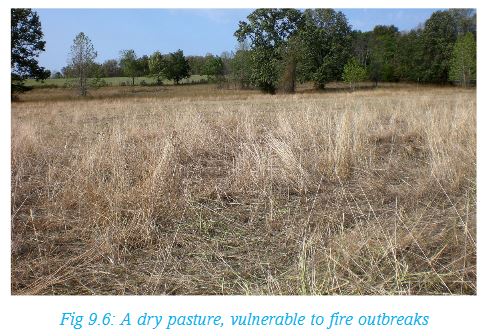
• Reduced recreation and tourism activities, especially when wild animals migrate in search for pasture and water.
b) Landslides
A landslide occurs when a large mass of earth, rock or other material move down a slope. The process may be slow, taking place over a long period of time, or rapid. In most cases, rapid landslides can be destructive to life and property.
Due to climate change, there are cases of extremely heavy rains received in some parts of our country. This has caused a lot of destruction, such as landslides. Landslides occur when there is persistent rainfall in highland areas with inadequate cover. Oversaturation of the topsoil with water causes it to move downslope, sometimes abruptly.
For instance, on 3rd April 2015, heavy rainfall caused flooding and landslides in Nyamasheke and Rubavu districts in Western Province.In some cases, heavy rains on the sandy soils on the hills has resulted into landslides, leading to blocking of roads. For example, Mugoroba road was once blocked by a landslide, making it impossible for vehicles and pedestrians to pass.
Property, roads and people in Nyabihu District have also been victims of landslides in the recent past. There is destruction of property, loss of human and animal lives and destruction of homes as well infrastructure. Landslides also cause a destruction of the agricultural land in low lands and on hill slopes.
When soil is massively deposited into river channels after a landslide, it may cause flooding and overflow of water, leading to further destruction from floods.
Activity 9.9
1. In pairs, discuss the occurrence of landslides in Rwanda.
2. Explain the effects of landslides to: people, plants, animals, property, infrastructure, and river channels.
3. Which measures can be put in place to reduce the occurrence and effects of the landslides?
c) Floods
Floods occur when land is totally covered by water. It can be caused by an overflow from existing water channels. It can also be caused by persistent rainfall over a period of time, leading to overflowing due to oversaturation of the soil.
Changing weather patterns are also responsible for recurrent floods in Rwanda. This is also caused by more than usual rains.
Activity 9.10
Read the following story then answer the question that follows:
It rained heavily in Kicukiro yesterday evening. Mutoni got so worried that she thought their house could be swept away by floods. When she asked her father if this could happen, he replied:
“I once read from the website of reliefweb that in June 2012, there were floods in Musanze in Northern Province, and Nyabihu and Rubavu districts in Western Province. Many people were displaced, water supplies got affected and roads, schools, clinics and over 700 homes damaged. Crops in the farms were not spared either. In April 2015, heavy rainfall caused flooding and landslides in Nyamasheke and Rubavu Districts in Rwanda’s Western Province. As he concluded, he said,
“The rains experienced back then were four times more that what we are experiencing now. There is no need to worry,” he said.
In pairs, discuss the effects of floods using the story above. Generate a list of what you have discussed in your notebooks.
d) Aridity and desertification
Activity 9.11
1. Use the dictionary to differentiate between ‘aridity’ and ‘desertification’.
Explain how the two terms are related.
2. Mention any four deserts that you know.
3. Find out some human activities that lead to aridity and desertification.
4. Research from the Internet and from other geographical documents the effects of aridity and desertification in Rwanda.
Make a class presentation of your findings.
The government’s efforts to tackle desertification are clearly visible. Gishwati Forest for instance has undergone massive reforestation after it was almost cleared for human settlement and agriculture.
9.5 Climate change adaptation and mitigation in Rwanda
Activity 9.12
1. Using your dictionary, explain the meaning of adaptation and mitigation.
2. With the guidance of your teacher, take a trip around your school. Identify ways in which residents and the government have put in place to mitigate:
i. Droughts
ii. Landslides
iii. Floods
iv. Aridity and desertification
Write down your findings for a class presentation.
The following are some of the ways to lessen the effects of climate change in Rwanda:
a) Drought
• Efficient use of water when in plenty.
• Growing drought resistant crops such as cassavas, yams, bananas, millet and sorghum.
• Recycling water from industries and homes to ensure maximum usage of available water.
• Irrigating farms with available water to increase crop productivity.
• Storing excess water during the rainy season.
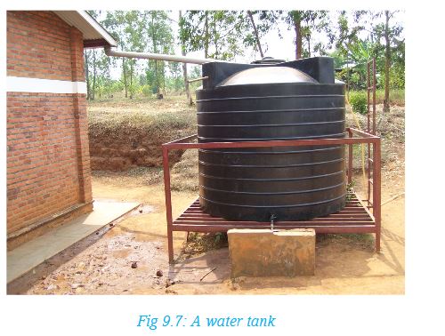
b) Landslides
• Afforestation on steep slopes prone to landslides.
• Application of improved farming methods on steep slopes by terracing and contour ploughing.
• Restricting settlement and infrastructural development on hill slopes.
• Building barrier walls on slopes that often experience landslides.
• Growing cover crops to slow the movement of water and increase saturation. Such crops also hold the soil particles together firmly.
c) Floods
• Improving drainage through construction of pumping stations, water gates, culverts and water tunnels.
• Keeping drainage channels clear to enable water to flow within the confines of the channels. This includes unblocking them when congested with silt and garbage.
• Construction of check dams to store excess water during the rainy season. This can also include extending areas that serve as retention basins to increase their capacity to hold more water.
• Limiting construction of permanent structures near or across water courses.•Avoiding disposal of wastes in water channels.
• Discouraging deforestation that increases surface runoff, causing siltation and subsequent flooding.
d) Aridity and desertification
Efforts to combat aridity and desertification in Rwanda include:
1. Advocating for a reduction of livestock numbers to reduce chances of overgrazing.
2. Improving in farming methods to avoid the effects of monoculture and other methods of farming.
3. Sensitising the public on the need for smaller families in order to reduce the need for more housing.
4. Carrying out tree planting campaigns to increase the forest cover and restore forests that were once cleared.
5. Subsidising alternative sources of energy to substitute the use of charcoal and firewood.
6. Educating the public on the causes and effects of aridity and desertification, and possible ways of how to curb the same.
END OF UNIT REVISION QUESTIONS
1. In your note books, draw the map of Rwanda showing the climatic zones of Rwanda.
2. Write down the indicators for climate change in Rwanda.
3. Explain the causes and effects of climate change in Rwanda.
4. Write an essay on the measures being taken in Rwanda to mitigate effects of climate change.
Unit 10: VEGETATION IN RWANDA
Key unit competence
At the end of this unit, you should be able to explain the importance of different types of vegetation in Rwanda.Introduction
The environment that is around us is covered with different types of plants. Some of the plants occur naturally. This is the vegetation that grows as a result of the natural conditions that exist in an area. Other areas have types of vegetation that has emerged as a result of human activities. In whichever, way the vegetation of a place has occurred, it consists of a combination of trees, shrubs, grass and weeds.
10.1 Types of natural vegetation in Rwanda
Natural vegetation is the plant life that grows in a place as a result of natural factors. These factors include the amount of rainfall received, the nature of soils and temperatures among other natural factors.
Activity 10.1
1. From outside your classroom, observe and make a list of all the types of vegetation both within and outside the school compound.
2. Draw a table with two columns in your note book and indicate the natural vegetation in one column and planted vegetation in the other.
3. Discuss the similarities and differences in the two types of vegetation and make a class presentation on your findings.
Any part of the earth where human activities are limited is covered with different types of plants that have grown naturally. Rwanda has areas that have natural vegetation especially in the places that have been set aside as reserves and the areas that are not accessible.
The map of Rwanda below shows regions with different types of natural vegetation.
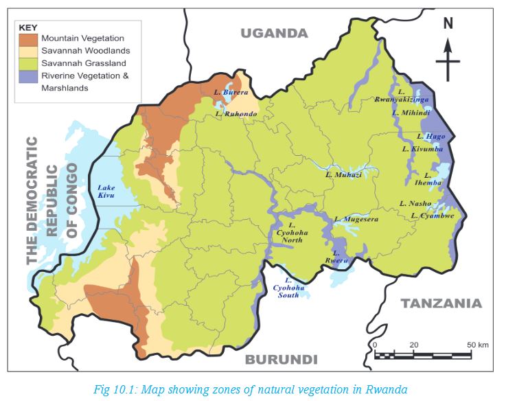
Much of Rwanda’s natural vegetation has been cut down.
People clear vegetation as they create room for farming and settlement. They also cut trees to obtain building materials and firewood. Natural vegetation is mainly found in the three large national parks and four forest reserves.
Activity 10.2
In groups of five:Carry out a research from various geographical documents, the Internet and from Rwanda Environment Management Authority.
Find out the reasons that may have led to clearing of natural vegetation in Gishwati Forest. Make notes from your findings in your notebooks for class presentation.
Remember!
After the 1994 Genocide against the Tutsi, many survivors had to settle down again. This meant that they were to build houses and find land for farming. As a result, much of the vegetation was cleared to facilitate this. It is easier to destroy the natural vegetation than restore it. This is why it took a long time to restore vegetation cover. It has been the responsibility of all of us to take care of the environment. This is one way of being responsible citizens!
Natural vegetation in Rwanda can be divided into four main categories. These are:
(i) Mountain forests
(ii) Savanna woodlands
(iii) Savanna grasslands
(iv) Riverine vegetation and marshlands
Mountain forests
The mountain forests are found in the mountainous western part of the country. The largest areas of these forests are the Nyungwe Forest National Park and the Volcanoes National Park. These two forests are reserves that are also conservation areas for wild animals. The mountain forests are true rain forests which have more than 200 species of trees and a variety of flowering plants. They also have large areas of bamboo forests while tall coarse species of grass dominate the open areas within the forest.
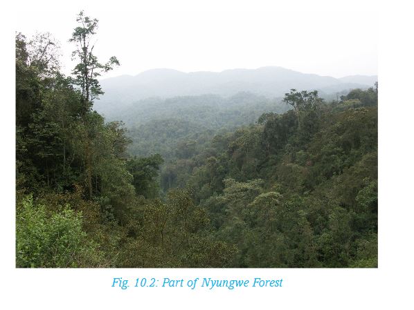
Savanna woodlands
The largest areas in Rwanda that are covered with woodland type of vegetation are the plains in the southern parts of Rwanda and Bugesera District.
The vegetation in the woodlands is characterised by hardwood type of trees that are medium height and short scrubs that have many shoots from one stem.
Activity 10.3
1. Ask your parent or guardian to help you identify types of natural vegetation in your local environment. Write down both their Ikinyarwanda and their English names.
2. In the following table, identify the soft wood and hard wood trees in Rwanda today. Ensure you get photographs to show these two types of trees. In this case, you can visit a nearby forest in groups to take photographs. You can also use the Internet and other sources of geographical information to obtain these photographs.
Present your information in a table as shown.

Many of the plants in the woodlands are thorny with small leaves. Occasionally there are tall umbrella shaped acacia trees rising above the level of the scrub vegetation. Their numbers increase along the river valleys.Much of the woodland vegetation has been cut down to give way to farming and settlement. There is also deforestation resulting from charcoal burning. This has left only patches of the natural woodlands and some scattered trees which shed their leaves during the dry seasons to appear like dry wood.
Savanna grasslands
Savanna grasslands are found on the lower slopes including the hills in the central part of the country. These zones have natural vegetation that consists of thick, tall highland grass with scattered trees. The drier plains in the eastern parts of the country support open savanna grasslands with scattered woody trees such as acacia. Much of the grasslands are grazing areas for livestock while part of the areas is the Akagera National Park.
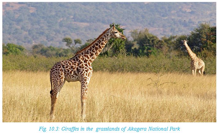
Riverine vegetation and marshlands
This type of vegetation is found in wetland areas such as Rugezi swamp (Burera District) and along rivers, including Akagera, Nyabarongo, Rusizi and other smaller river valleys. The vegetation consists of lowland forests and papyrus swamps. Parts of the wetlands are threatened by invasive plants such as water hyacinth. These plantsgrow rapidly, covering the top surface of the water and replacing the original vegetation.

10.2 Factors that influence vegetation distribution in Rwanda
The growth of plants in any place is determined by a combination of a number of factors. In Rwanda, vegetation varies from place to place due the different factors that are dominant in different areas. There are four main categories of factors that influence vegetation in Rwanda. These are:
(i) Climatic factors
(ii) Topographical factors
(iii) Edaphic or soil related factors
(iv) Biological factors
Activity 10.4
In groups, carry out a study of the area around your school.
1.Identify and describe the type of natural vegetation in the area.
2.Identify and explain the planted vegetation in the area.
3.Explain how the following climatic factors would influence vegetation distribution.
a) Rainfall
b) Temperature
Present your findings for class discussion.
(i) Climatic factors
The main climatic factors that influence vegetation in Rwanda are rainfall and temperature.
(ii) Topographical factors
This refers to the nature of the landscape. It is described in terms of the slope. It can be termed as steep, gently sloping or flat. The very steep slopes on the mountains in Rwanda have scarce vegetation. This is because they lack sufficient soil to support plant growth. However, the gentle slopes are covered with forests. Flat areas and river valleys have thick swamp vegetation that is supported by the water from the rivers.
(iii) Edaphic or soil related factors
The depth and fertility of soils have a direct effect on the type of vegetation in a place.
The slopes of the mountains and hills in Rwanda have deep fertile soils that supports thick forests. The soils in the swampy areas support plants that survive in waterlogged soils. These include papyrus plants and water weeds.
(iv) Biological factors
These factors include the effect of animal and human activities on the vegetation.
Activity 10.5
In groups, discuss how human beings and animals influence vegetation.
Write down your findings to present to the class.
10.3 Importance of different vegetation types
Vegetation is not only important to people but also to both domestic and wild animals. Vegetation is also important to the environment. The importance of vegetation can be looked at in terms of economic and social benefits we get from it.
Activity 10.6
In groups, use the atlas, various geographical documents and the Internet to:
1.Identify places in Rwanda where swamp vegetation is found.
2.Explain the different uses of swamp vegetation.
Make a class presentation on your answers.
(i) Importance of forests
Activity 10.7
1. Identify one of the items you use frequently that is made from vegetation.
2. Forests are sources of rivers. They are also home to wild animals. In groups, generate a list of other reasons why forests in Rwanda are important.
(ii) Importance of woodlands
a) Woodlands in Rwanda are the main sources of the charcoal that is used in homes.
b) Woodlands provide firewood and timber for building.
c) There is bee keeping and collecting of medicinal herbs in the woodlands.
d) Some wild animals live in woodlands. They are attraction to tourists. This is important because tourism generates income for the government as well as creating employment opportunities.
e) The open areas where the bushes are not so thick have grass where animals graze.
(iii) Importance of grasslands
a) Grasslands are important because they provide pasture for livestock. Many of the pastoralist in Rwanda who keep large herds of livestock are found in the grassland areas in the eastern parts of the country.
b) Some of the grasslands have been set aside for wildlife conservation and are home to a variety of grazing animals. Most of the Akagera National Park is within the grassland region.
(iv) Importance of swamp vegetation
Activity 10.8
1.Identify the main type of swamp vegetation.
2.Explain how swamp vegetation is used.
10.4 Impact of man’s activities on vegetation in Rwanda
Rwanda is a small country with a total area of 26,338 square kilometres and with a population of about 11.5 million (National Institute of Statistics - Rwanda - 2016). The density ranges from 250 to 380 people per square kilometres. For this reason:
a) There is a very high demand for land. As a result, people are forced to settle and farm in any available land including the steep hill slopes.
b) The original vegetation in most parts of the country has been cleared to give room for farming and settlement.
c) Former forests areas are currently farms and homesteads.
Activity 10.9
Study the photograph below and answer the questions that follow.
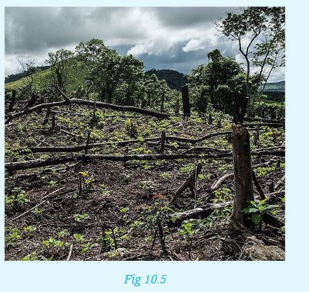
1. Describe the type of vegetation shown in the background of the photograph?
2. Explain reasons that may have led to the clearing of vegetation in the area.
3. Describe the activity that has taken place in the photograph.
4. What effects will this activity have in the area in future?
5. Give examples of places in Rwanda where this photograph may have been taken.
6. Which measures can the government of Rwanda put in place in order to conserve natural vegetation?
Compile a report for discussion in class.
10.5 Measures to conserve natural vegetation in Rwanda
Activity 10.10
In groups, carry out a field study of the area around your school:
1. To assess the impacts of human activities on vegetation
2. To find out the vegetation conservation measures that people have put in place.
Prepare a report for class presentation.
Vegetation conservation and management plans have been put in place in many parts of Rwanda. The government has plans to achieve 30% forest cover by 2020. Together with non-governmental organisations, the government involves the local communities in conservation activities. This is widespread but more common in villages that are close to the protected areas.
(State of Environment and Outlook Report, REMA 2015)
Specific measures include:
i) All over the country, there are conservation activities within the major forest areas. Focus is on increasing the forest cover by planting trees of the same species as in the original forests. For example, a large area of Gishwati Forest has had wild tree species planted to increase the acreage of the forest. The forests are then protected by fencing on the boundary of the forest reserves using leguminous thorny plants.
ii) There is a deliberate effort by the Government of Rwanda to increase the number of protected areas. It also aims to promote tree plantations and expand the present forest cover.
iii) There are laws that allow those found cutting trees illegally to be arrested and jailed.
iv) The government has also rolled out a countrywide agro-forestry programme encouraging farmers to plant trees within their farms. To support this initiative, they are supplying them with tree seedlings.
END OF UNIT REVISION EXERCISE
1. Name two vegetation types in Rwanda and for each give an example of a region where it is found.
2. Explain how rainfall influences distribution of vegetation in Rwanda.
3. What is the importance of Nyungwe Forest to the population around it?
4. Explain why it is important to conserve vegetation.
5. What role do the local communities in Rwanda play in conservation of vegetation?
Unit 11: DRAINAGE IN RWANDA
Key unit competence
At the end of this unit, you should be able to investigate the importance of drainage and the challenges of obtaining sustainable and clean water in Rwanda.Introduction
Water is one of the important resources for human survival.The sources of water in Rwanda include lakes, rivers, swamps and ground water.
Availability, access to water and supply plays an important role in the type and distribution of plants, animals and human activities. Even though Rwanda has many water resources, they are not enough to serve all people equally and for a long time. Consequently, there is need for Rwanda to manage and conserve the available water resources.
Activity 11.1
Keep exploring!
With the help of your teacher, study a nearby water body and find out the following:
1.What is the name of water body, if any?
2.Where does the water in the water body come from?
3.In which months of the year does the water body have plenty of water?
4.In which months of the year does the water body have low volume of water?
5.What human activities have:
i.Positive influence on the water body
ii.Negative influence on the water body
Compile your findings for class discussion.
11.1 Major rivers, swamps and lakes in Rwanda
Rivers, swamps and lakes are some of the features that make up a drainage system. Drainage refers to the process by which water moves or exists on the surface of the earth.Activity 11.2
In pairs, study the drainage map of Rwanda provided then answer the questions that follow. Generate a list of:•The main rivers in Rwanda.•The main lakes in Rwanda.•The main swamps in Rwanda.
Rivers in Rwanda
A river is a mass of water flowing in a defined channel. A river takes a definite direction from its source to the mouth. Rivers originate from highlands, forests and wetlands such as swamps.
Small rivers are called streams. Streams naturally derive most of their water from precipitation in the form of rain and snow. Many streams join to form a river. Rivers are either permanent or seasonal. A permanent river is one that has continuous flow throughout the year when there is normal rainfall. A river whose flow decrease or cease for weeks or months during the dry season or onset of drought is said to be seasonal.
Rwanda has many rivers. Most of these rivers are found on the western part of the country. All these rivers pour their water into Lake Kivu. However, other rivers are found in different parts of the country.
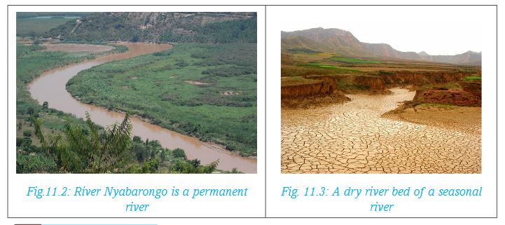
Activity 11.3
Copy the following table that shows the major rivers in Rwanda. Use the Atlas internet sources or any other relevant materials to complete the table.
Swamps in Rwanda
A swamp is a low lying area that is seasonally or permanently covered by water. It is also referred to as a marsh. In Rwanda, swamps are found in areas such as Kamiranzovu and Gishoma and vallies of major rivers such as Nyabarongo, Akagera and Akanyaru. Others are found on the edges of lakes Mugesera, Sake, Ruhondo and Burera.
Activity 11.4
1. In groups, use the atlas to identify swamps and wetlands in Rwanda.
2. Discuss some economic activities that take place around swamps and wetlands.
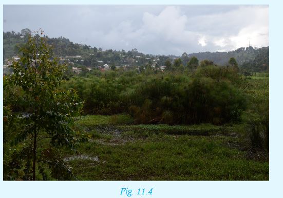
Lakes in Rwanda
A lake is an area of irregular size filled with water, found in a basin. It could also mean a hollow on the earth’s surface occupied by water. Lakes are either natural or human-made. They are particularly varied in terms of origin, size, shape and depth. In addition, lakes may be fresh-water or salt-water. A lake usually has a river or stream draining into or out of it.
Activity 11.5
1. Use the Atlas trace out the map of Rwanda.
2. On it mark and name the following lakes: Kivu, Ruhondo, Muhazi, Cyohoha, Sake, Mugesera, Nasho, Mpanga, Ihema, Mihindi and Rwampanga.
11.2 Formation of lakes in Rwanda
Lakes are formed by a variety of processes which include:
a) Tectonic or earth movements
b) Vulcanicity
c) River deposition
d) Human activities
Lakes formed by tectonic or earth movements
Earth movements involve faulting and warping of the earth’s crust. This causes downwarping, tilting and faulting of the crust producing tectonic basins. Water then collects in these basins either from streams or from underground sources. This way, a lake is formed. Lakes formed this way are long, narrow, deep and steep sided. For instance, Lake Kivu was formed by faulting while Lake Muhazi was formed by crustal warping.
For you to find out:
In pairs, find out from various geographical documents and the Internet an example or examples of a lake or lakes formed as a result of tectonic or earth movements. Write short notes for class presentation.
Lakes formed by vulcanicity
There are two types of lakes formed by vulcanicity. These are:
•Crater lakes • Lava-dammed lakes
Crater lakes
The lakes are formed when amassive explosion or collapse of the top of a volcano occur leading to the formation of a depression. Water may collect in such hollows forming a lake. Such lakes are characteristically circular in shape. They have no outlets and are generally salty. A crater lake in Rwanda is found on Mt Bisoke.
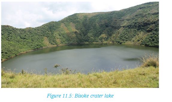
Lava-dammed lakes
They are lakes that form when lava solidifies across a river course, creating a barrier. The barrier blocks the flow of a river, forming a lake.
Examples of lava-damed lakes are Burera and Ruhondo.
Lakes formed by river deposition
Oxbow lakes
These are lakes that form along the course of a river. The lakes are formed in the lower course of the river where it flows through meanders or pronounced bends.
How do such lakes form?
Step 1: The outer side of bends is eroded away more rapidly than the inner side.
Step 2: With time, the river cuts through the narrow neck of the meander. This isolates a horse shoe-shaped lake called an oxbow lake. The lake is separated from the river channel by deposition of sediments.
Step 3: When an oxbow lake dries up, it forms a meander scar.
Examples of oxbow lakes are lakes Ihema and Hago on Akagera River.
The diagrams below show how an oxbow lake forms.
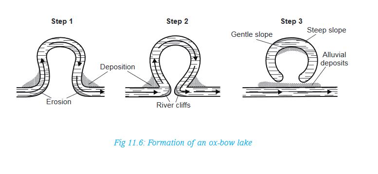
Alluvial lakes
These are lakes that are formed by river reversal in depressions. Examples of such lakes are Rweru and Cyohoha.
Human-made lakes
These are lakes formed as a result of blocking or deliberate construction of a dam blocking across the narrow steep sided section of a stream. Water accumulates behind the dam to form the lake or water reservoir. Examples of such lakes include Ntende, Kanyonyomba (in Gatsibo) and Kabgayi (in Muhanga District).
11.3 Importance of water bodies in Rwanda
Water bodies in Rwanda provide water both for domestic and industrial use. The water sources also provide sites for aquatic life. The government also benefits from water sources. For example, some of them are tourist attraction.
Activity 11.6
In groups, discuss the importance of the following water bodies in Rwanda:
i. Rivers
ii. Swamps and wetlands
iii. Lakes
Present the findings to the class for further discussion.
From the class discussion, it is evident that water bodies such as lakes, rivers and swamps are of significance to Rwandans as follows:
a) Water is important for good health. Our bodies need about 8 glasses of clean and safe water every day.
b) Rwanda gets water for domestic, industrial use, irrigation and hydro-electric power production from rivers and lakes.
c) Water bodies are natural habitats for a variety of unique plants and animals. They form tourist attraction sites for recreation. Sport fishing, and boat racing are also practiced. The picture below shows a hotel on the shores of Lake Kivu.

d) Lake Kivu modifies the climatic conditions of the adjacent areas. Sea breezes and convectional rainfall are common.
e) The water bodies provide natural route ways to transport goods and people. Some like Lake Kivu provide a link between Rwanda and her neighbouring countries.
f) Swamps act as natural water purification sites. They also serve as sources of water for lakes. They connect rivers in the country such as Kamiranzovu in Nyungwe and Rugenzi in Burera. The swamps also help in ground water recharge.
g) Water bodies form major inland fresh water fisheries which is a source of food, and income for families and communities.
h) Some lakes are sources of minerals. For example, methane gas is mined from Lake Kivu which is a source of energy.
i) Sand and clay scooped around the water bodies is used in building and construction.
11.4 Challenges to obtaining sustainable and clean water in Rwanda
Activity 11.7
Gahigi was diagnosed with cholera when he visited a hospital in their district. It was found that he had drank contaminated water from a nearby river.
1. In pairs, describe the factors that could have contributed to contamination of the river water.
2. Explain ways of purifying water..
Water directly influences the quality of people’s life, their health and productivity. Access to clean and safe water is therefore important. Although Rwanda possesses abundant water resources, there are challenges to obtaining clean water. Some of the challenges are:
a) People lack comprehensive information and awareness on the importance of careful use of water resources. They also lack adequate infrastructure to harvest and store water.
b) Climate change has contributed to degradation of water bodies with a decrease in amount and quality of water. For example, the quality of water deteriorates during floods and times of drought.
c) The conversion of wetlands to agricultural farms has increased rapidly due to scarcity of farmland. This has led to enormous pressure on the wetlands as sustainable sources of water.
d) There has been an increase in demand for food due to increasing population. This has led to use of fertilisers necessary to boost agricultural production. When used in excess, fertilisers are washed into lakes and rivers. This encourages the rapid growth of water plants on water surfaces. This is not only threatening to the lifespan of lakes and rivers but also has detrimental effects on water quality.
e) The discharge of untreated waste (both domestic and industrial) directly into water bodies causes water pollution. This has rendered water unsuitable for direct consumption and increased the cost of treatment before utilisation.
f) Increased infrastructural and housing developments associated with urbanisation has led to lowering water infiltration and increasing runoff. The double negative effect has increased soil erosion and chances of flooding.
11.5 Conservation and management methods of water bodies in Rwanda
Activity 11.8
When a new development affects a community, a public meeting is often held to pass information to the local people and allow them to air their views.
1.Using a dictionary, differentiate between conservation and management.
2.In groups, write down five key factors you would give the community as the advantages of managing water bodies.
3.Explain methods of purifying water used in homes and industries.
Share your answers with other group members.
Over the years, there have been various challenges in the water sector in Rwanda.
Water management refers to the effective planning and control of the processes and activities that are likely to cause worsening of water resources.
Available options for providing safe drinking water include:
a) Developing and maintaining strategic boreholes, traditional dug wells, water pans and supply lines to improve access to water.
b) Increasing capture and storage of rainwater to ensure availability of water during the dry season, particularly roof harvesting at household level.
c) Organising focused awareness campaign that simplifies the need for sustainable use of water resources, in a language that is clearer to people particularly those in rural areas.
d) Involving water users including gender groups, administrators and non-governmental organisations in water resource management.
e) Enforcing laws against destruction of water resources.
Water conservation
This is the protection and preservation of water resources from destruction or wastage.
Did you know?
The Egyptians were the first people to record methods for treating water. These records date back more than 1,500 years to 400 A.D. They indicate that the most common ways of cleaning water were by boiling it over a fire, heating it in the sun or by dipping a heated piece of iron into it. Filtering boiling water through sand and gravel and then allowing it to cool was another common treatment method.
Activity 11.9
Take a walk in the area surrounding your school. With the help of your teacher, identify measures put in place in order to conserve water in the area. Take notes for a class discussion.
Water can be conserved through:
a) Recycling/re-using: This refers to utilising wastewater from one process to another where lower-quality water is acceptable. This is meant to reduce the amount of wastewater, pollution and all together increase water supplies.
b) Treating or disinfecting community wells and boreholes during drought and floods. This is to maintain water quality.Water treatmentis the process of cleaning water. Treatment makes the water safe for people to use. Treatment includes disinfection with chemicals to kill any germs in the water.
Sustainability of water is the continual supply of clean water for human uses and for other living things.
c) Removing invasive plants: Physical removal of the alien plants is a low-cost measure to improve an area’s water quality.
d) Promoting community empowerment initiatives through high value economic activities such as fishing, beekeeping as well as value addition so that communities are motivated to protect the water catchment areas.
e) Protecting water catchment areas/water towers, river banks and water bodies from destruction and contamination.
For you to find out!
How can you ensure that water is conserved at home?
END OF UNIT REVISION EXERCISE
1.What is the origin of water bodies in Rwanda?
2.a) Draw a sketch diagram of the feature below.
b) Use simple diagrams to describe how it could have formed.
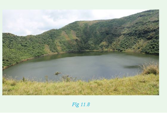
3. a) Describe how Lake Kivu was formed.
b) Explain how communities make use of the waters of Lake Kivu
4. Match the following activities with the correct process.The first one has been done for you.

5. Supposing you are a member of the water club, you have been asked to share with the class wise use of water.Prepare five key points for the presentation.
Unit 12: ENVIRONMENTAL CONSERVATION IN RWANDA
Key unit competence
At the end of this unit, you should be able to investigate the factors responsible for environmental degradation and the consequences of excessive use (over-exploitation) of environmental resources.Introduction
Conservation of the environment involves the protection and preservation of natural resources so that they do not get exhausted. It is important to apply good practices in the way we use the resources. If we use resources like forests and soils excessively without caring, our country will degenerate into a desert.
The environment contains both renewable and non-renewable resources.
The renewable resources should be used carefully so that they are given time to regenerate.
To learn more about environmental conservation we shall cover the following sections.
(i) Definition of environmental resources and environmental degradation.
(ii) Types of environmental resources in Rwanda.
(iii) Ways of exploiting environmental resources.
(iv) Causes and consequences (effects) of over-exploitation of environmental resources.
(v) Environmental conservation measures (ways of upgrading the environment).
12.1 Definition of environmental resources and environmental degradation
Activity 12.1
Using your dictionary, find out the meaning of the following words:
a) Environment
b) Resources
c) Renewable
d) Degradation
Environment refers to the surroundings. Whatever is around us is our environment. Natural environment is made up of all living and non-living things that exist without the influence of human beings. These include land, animals, vegetation, air, water and physical features.
Environmental resources refer to what exists within the environment that can be exploited for use by human beings. For instance, soil, minerals, vegetation and water are resources that we need for survival.
Some resources can be renewed while others are not renewable. For example, once minerals are extracted from the ground, they cannot be renewed. Minerals are non-renewable resources. Vegetation can be renewed by planting more trees or other plants. Vegetation is a renewable resource.
Environmental degradation occurs as a result of misuse or careless use of the environment. This leads to deterioration of the quality of the environment. For example, soil erosion and deforestation are forms of environmental degradation.
Activity 12.2
Study the photograph below and answer the questions that follow:

1.Describe the state of the land in the area.
2.Explain what may have happened for the land to become as shown.
3.In which parts of Rwanda are you likely to witness this situation?
4.Explain some of the ways in which this land can be made useful again.
Environmental degradation occurs as a result of human activities. We must use the resources in our environment sustainably so that they do not run out. This means that the rate at which we use these resources should not exceed the rate of regeneration or renewal. For example, for each tree we must cut, we should always replace it with two or more trees.
12.2 Types of environmental resources in Rwanda
Rwanda has many different types of resources. They are both living and non-living.Land, soil, minerals, air and water are non-living resources.
Vegetation and animals are living resources.
Activity 12.3
1.List down other resources found in Rwanda other than the ones mentioned above.
2.Classify the following resources as either a renewable or non-renewable resource.
• Land
• Soil
• Water
• Minerals
• Animals
• Vegetation

Give reasons for the classification you have come up with.
a) Land
Land is a scarce resource in Rwanda. This is because the population is ever increasing while the size of the land remains the same.
Activity 12.4
1.In groups, state ways in which land is a useful resource.
2.Describe ways in which land can be rehabilitated.
Each family needs land for farming and settlement. As a result, families own small pieces of land and have to utilise the land carefully so that it continues to sustain them. Land where minerals, building stones and sand have been extracted should be rehabilitated. However, it is better to use the land well than to work towards rehabilitating it later.
b) Soil
Activity 12.5
1.In pairs, discuss the uses of soil as a resource.
2.Using the knowledge gained from the study of Unit 5 in this book:
i) Explain factors that lead to soil degeneration and exhaustion.
ii) Briefly describe types of soil erosion.
iii) Describe methods used to conserve and protect soils.
Soil is another very important resource because it is the one that sustains plant growth. Soil degenerates either through soil erosion or by losing its fertility.
In Rwanda, many areas are hilly. For this reason, farmers are forced to use cultivation methods that protect soil from degradation. They plough along the contours and plant cover crops on these bands to hold the soil and avoid erosion by rain water. They also use organic manure to enrich the soil with nutrients.
c) Water
Activity 12.6
1.In groups, come up with a list of water resources in Rwanda. Give examples where possible.
2.Enumerate the uses of water resources.
3.Describe ways in which water resources can be protected.
Water resources in Rwanda are in form of rivers, lakes, wetlands and rain water. Lakes and rivers get water from rainfall and from springs found in the highlands. Water sources have to be protected so that the rivers and lakes do not dry up. In addition, we must protect water from pollutants to keep it clean for human and animal use. It is important to harvest rain water and store it for use during the dry seasons.
d) Minerals
Activity 12.7
1.In groups, use an atlas to identify various minerals mined in Rwanda.
2.Where are the minerals in (1) above mined?
3.Explain the importance of minerals to the economic development of Rwanda.
4.Discuss ways in which derelict land can be rehabilitated.
Minerals are non-renewable resources. Rwanda has minerals such as tin, tungsten and tantalum. These minerals are extracted and once removed they do not regenerate. Sustainable exploitation of minerals means that once exploited, the mineral must be used to bring about development.

Minerals are usually exported to earn the country foreign exchange. This money is then used to develop industries and other sectors such as road construction and building schools, colleges and hospitals.
e) Vegetations
Activity 12.8
1.Take a walk around your school. Identify and list the types of plants around your school.
2.Describe the importance of vegetation as an environmental resource.
3.Outline ways in which vegetation can be protected and conserved.
Vegetation is an important resource as it is the source of things like timber, firewood and food for animals. Natural vegetation is also home for wild animals and also a source of valuable products like herbs and honey.
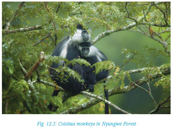
f) Animals
Animals are also an important resource. Domestic animals are a source of meat and milk. Wild animals are tourist attraction and through tourism, the country gets foreign exchange. Fish resources also earn income as well as providing meat.
Activity 12.9
1.Use the table below to give the types of domestic and wild animals in our country.

2.Explain ways in which the animals mentioned above are useful resources.
12.3 Ways of exploiting environmental resources
Land
In Rwanda, parts of the land under natural vegetation are used for various purposes. Some are used as national forest reserves, wildlife conservation parks, protected water catchment areas, national wetlands and areas for urban development. The rest of the land belongs to the people who own pieces of land and are free to use it in a way to sustain crop production.

Farming land is a very valuable resource yet it is highly fragmented and most people own small pieces. The central part of Rwanda is hilly and very densely populated. People own land on these slopes of the hills. They are forced to use their land carefully so that they can get as much crop yields as possible every season. Part of each family’s small piece of land is set aside for the homestead while the rest is for growing crops and grazing.
Soil
People who live on the hilly areas practice contour farming and terracing on their farms. This helps keep the soils stable so that it is not carried by rain water. The other challenge is that farming is done continuously on the small pieces of land. This causes the soils to become exhausted leading to low crop yields. The farmers have to use fertiliser and manure to improve soil quality.
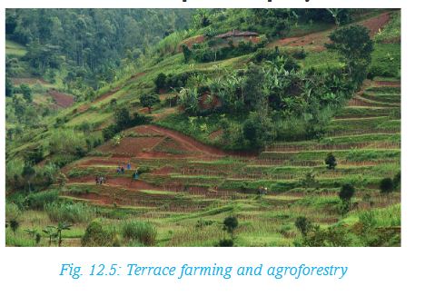
Vegetation
Rwanda’s natural vegetation is found in very few areas which have been set aside as forest reserves. The biggest is the Nyungwe Forest Reserve. Cutting of trees in the forest reserves is strictly prohibited. There are forest guards who are employed to ensure that only those licensed are allowed to cut trees. As trees are cut down, more trees must be planted so that there will be no time there is a shortage of trees. Farmers are encouraged to practice agroforestry where they plant trees on their farms together with the crops.
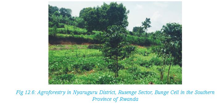
Other trees are planted along the river valleys to control possible erosion by the river on the banks. The trees also provide firewood and timber.
Rwanda has a national tree planting day when everybody is expected to plant a tree. However, tree planting is a continuous process. Tree nurseries are prepared by the government and by individuals to supply seedlings all the time.
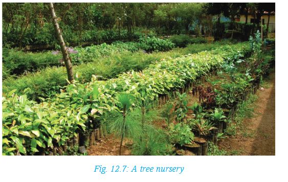
Wildlife
Wild animals are a very important resource in Rwanda. They are a national heritage that has to be carefully used. Wild animals are tourist attraction and enable the country to earn foreign exchange. Without animals like the mountain gorilla, the number of foreign tourists would be very small. Animals must therefore be taken care of. National parks are set up so as to protect these animals from poachers. We must avoid hunting wild animals unless we have been given a license to do so.
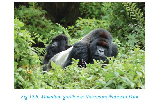
Water resources
The water resources in Rwanda are lakes, rivers, wetlands and rainwater.
•These sources provide water for domestic, industrial and agricultural use.
•The lakes, rivers and some swamps are important sources of fish.
•Rivers in Rwanda provide water for irrigation and generating hydro-electric power.
Remember!
Lakes such as Kivu are threatened with over-exploitation of fish. This is because fishermen use nets with small mesh and catch young fish. Fish breeding is affected as all the fish gets caught. Fishing can only be done sustainably by restricting fishing and the fishing methods to protect the young fish for continued breeding.
Wetlands are threatened by pollution, clearing of vegetation such as reeds and farming within and around the swamps. These practices are controlled through giving advice on sustainable use of the wetlands. Those living near the wetlands are advised to avoid polluting the water by using poisoning method to catch fish. They are also asked to allow swamp vegetation to regenerate. Careful farming around the swamps protects the resource.
12.4 Causes and consequences (effects) of over-exploitation of environmental resources
Activity 12.10
In groups, research from geographical documents and internet on the effects of over-exploitation of:
1.Gishwati forests reserve.
2.Monocropping
Present your findings for class discussion
Land
Overexploitation of land in Rwanda happens because the population is very high and most of the people are small scale farmers. They own small plots of land which they cultivate every year. The land is not given time to rest since people have to farm to obtain food.
Activity 12.11
In groups, explain the effects of soil exhaustion.Prepare a report for class discussion.
Forests
Due to the high population, the demand for firewood and building materials is very high. This has led to exploitation of forests leading to reduced areas under forest. Some forest such as Gishwati were completely cleared until the government stepped in to control further exploitation. The current forest reserves are guarded to stop further tree felling that is not authorised. Tree planting activities have been stepped up to increase the areas under forests.
Animals
Animals, both domestic and wild, are important to us. We protect them from misuse or even killing them for selfish reasons.
Activity 12.12
1. Using an atlas, make a list of national parks and game reserves in Rwanda.
2. Explain why poaching has a negative effect on the economy of our country.
Fish
Over-exploitation of fish happens when fishermen use nets such as mosquito nets which catch all the fish both the young and the mature ones.The effect is that fish breeding process stops and the fishery has no more fish unless there is restocking and restricted fishing to allow fish to regenerate. Poisoning as a fishing method is dangerous because the poison kills all the fish and any other living things in the water. It is also dangerous to use such water for bathing or for cooking.
Wetlands
Due to scarcity of land, people have encroached on the wetlands removing the vegetation to allow for farming. Some wetlands have dried up as a result. Some wetlands have been polluted affecting all the living things both plants and animals in the water.
12.5 Environmental conservation measures (ways of upgrading the environment)
There are different methods of conservation of the environment.
Activity 12.13
Imagine that you are the government minister in charge of forests. You need to give advice to citizens on how to use forests sustainably on national television channel. Write a paragraph on each of the following points explaining what you would tell them:
1.Importance of conserving forests near water resources
2.The need for preparing tree nurseries and tree planting
3. Importanceofpreventingforestfires
4.Dangers of illegal tree cutting
5.Importance of agroforestry
Present your report for class discussion.
Remember!
World Environment Day (WED) is celebrated every year on 5th June. This is done to encourage people to use the environment reasonably so as to protect nature and the planet Earth. The day is organised by the United Nations Environment Programme (UNEP).
Land
Land conservation includes taking care of land itself, soils and vegetation.
Activity 12.14
With the guidance of your teacher, take a walk around the area surrounding your school. Observe, enquire and make notes on the methods used by the locals and the government to protect and conserve land.
Land conservation measures include:
(i) Using good farming practices - Farmers whose land is on sloping areas have to terrace their land to control soil erosion and sustain productivity.Cover crops such as bananas, sweet potatoes, tea and grass are planted to help conserve soils.
(ii) Proper planning of land use – Well planned land use ensures misuse of land is avoided. For example, the government has set aside some areas to be used as national forest reserves and wildlife conservation parks, protected water catchment areas, national wetlands and areas for urban development.
(iii) Protection of water catchment areas – Water catchment areas are conserved by ensuring that vegetation is not cleared as this can lead to the water drying up.
(iv) Planting trees in the farms (agroforestry) – Farmers are encouraged to plant trees in their farms to protect soil from erosion as well as supplying firewood and timber for building. Afforestation and reforestation programmes are also conducted to upgrade areas that had been affected by deforestation.
(v) Controlling of forest fires – Fire can destroy vegetation in large area within a short time. Forest fires are sometimes carelessly caused by those collecting honey or cigarette smokers. Land affected by such fires take long to recover its vegetation and soil fertility. Forest rangers are employed to ensure any fire spotted is put off before it spreads. They also guard forests against illegal cutting of trees.
Taking care of the land after mining
Minerals are non-living natural resources which are not replaceable once depleted. Minerals like tin, tantalum and tungsten which occur in Rwanda cannot be replaced once removed from the ground.
Mining has a serious effect on the land if care is not taken. The effect of mining on land is known as land dereliction. This is abandoning an area after mining has been done in a state which has little or no economic value. Once the minerals have been extracted, piles of waste rock and gaping pits are created within the mining area. Such waste land cannot support vegetation or agriculture unless it is rehabilitated. Usually, mining companies are unwilling to spend money on rehabilitation of such land. The government has to enforce laws to ensure the mining company fills up the pits and flattens the piles of waste rock then plants some vegetation before abandoning the site. This process is known as land reclamation. This is a process of making land useful by restoring it from quarries and wastes left after mining has taken place. This upgrades the environment in former mining sites.
Setting up aquariums on the mining pits can upgrade the environment.Such aquariums can be used as fish hatcheries for valuable fish species which can be used to restock the fisheries that are overfished.
Conservation of water
Conservation of water resources is a way of upgrading the environment. An area that has water attracts settlement, agricultural activities, and animal and plant life. All living organisms require water to survive.
Activity 12.15
In groups, discuss ways that can be used to conserve water resources. Write a report for a class presentation.
Water conservation processes include the following:
(i) Avoiding to discharge waste materials into water bodies. For example, owners of factories should not discharge oils and dirty water into lakes, rivers or swamps. Bathing in stagnant water makes it dirty and unsuitable for drinking. Excess soap in the water can destroy the animal and plant life in that water.
(ii) Protecting the vegetation around the sources of rivers. If springs are exposed to too much sun heat, the water will evaporate and rivers will dry up. The bamboo vegetation on parts of Nyungwe forest are protected because they help hold water that slowly feeds rivers.
(iii) Avoiding wastage of water. It is important to make sure that water pipes are not leaking and water taps are turned off after use.
(iv) Controlling soil erosion. Soil erosion leads to water pollution as silt is deposited in the water making is unsafe for drinking. Soil erosion leads to silting of rivers, lakes and swamps. If more and more silt is deposited in these water bodies, they become shallow could eventually dry up.
It is important to conserve wildlife for future generation.
(v) Harvesting and conserving rain water.
(iv) Building dams to hold storm water. Dams should be constructed on rivers in order to hold back water which is then released in a regulated way for people to use. Such water can be used for irrigation, for domestic use or for generating electricity. Where there are dams, water supply is guaranteed.
It is important to protect the vegetation around river catchment areas.
Conserving wildlife
Conserving wildlife is a way of upgrading the environment. This is because wildlife is a resource that enables the government to generate income.
Activity 12.16
Write a paragraph on the ways that the Volcanoes National Park contributes to the economy of Rwanda.
We should avoid over exploitation of wildlife through poaching. This way, the environment where these animals live will remain valuable to the country.
END OF UNIT REVISION EXERCISE
1.Explain the meaning of:
(a) Environmental resources
(b) Environmental degradation
2.Give three proper ways of farming that protects soils from erosion.
3.Explain the causes of over-exploitation of forests in Rwanda
4.Describe the measures that should be taken to ensure water resources in Rwanda are conserved.
Unit 13: POPULATION IN RWANDA
Key unit competence
At the end of this unit, you should be able to discuss the demographic problems and possible solutions in Rwanda.Introduction
Rwanda is one of the densely populated countries in the region. The 2012 census indicated that the country had a total population of 10,515,973 people of which 52% are women and 48% men. The population density in 2012 was 416 inhabitants per square kilometre. The population of Rwanda is young with one in two persons being under 19 years old.
Activity 13.1
In groups of five, use your dictionary, internet and geographical sources to find out the meaning of the following terminologies:
a) Population
b) Population distribution
c) Population density
d) Population structure
e) Population growth
f) Census
g) Migration
h) Demography
Present your findings to the class for discussion.
The study of population helps us understand how the number of people in an area may be increasing or decreasing. The study of population helps us appreciate the importance of having smaller families. To achieve this, various methods of family planning may be explored from time to time in the course of this unit.
This study also enables us to understand the dangers that face a population. This include sexually transmitted diseases that may bring immature deaths. Such knowledge helps us know how to avoid risky sexual behaviour.
To the government, understanding the population in the country is the basis for planning. For instance, it is able to plan how it will ensure adequate food supplies at all times. It can also plan on how to provide services such as health and education. It can as well use this understanding to plan for infrustructural development including transport network, supply of water and electricity among other services.
13.1 Factors influencing population distribution and density in Rwanda
Population distribution refers to how people are settled or spread out in the country. Population density on the other hand is the number of people living within unit area. In Rwanda, population is unevenly distributed. Some areas have high density while other areas have low density.
Activity 13.2
Study the map of Rwanda provided below showing population distribution in Rwanda then answer the questions that follow:
1.Describe the distribution of population in Rwanda.
2.Suggest reasons as to why the eastern and south western parts of Rwanda have low population density.
3.Suggest reasons as to why the central part of Rwanda has high population.
4.Propose the measures the government should take to avoid having too many people in one part of the country.

The following factors influence people to settle in certain areas in Rwanda.
a. Relief
b. Rainfall
c. Soil fertility
d. Land ownership
e. Government policy
f. Urbanisation
g. Occurrence of minerals
h. Historical factors
Activity 13.3
1.In groups, discuss how each of the factors mentioned above may encourage or discourage people to settle in an area.
2.Explain how these factors have determined the way people are settled in local area. Ensure you give specific examples from your area. Include any other factors that may be applicable other than the ones discussed above.
Make a class presentation from your findings.
The following text explains how each of these factors have determined the way people are settled in Rwanda.
a) Relief: Although there are many people living on the slopes of the hills, they avoid areas that are very steep. This is because these areas may be prone to landslides. Places like Gicumbi and Gakenke have fewer people because of the steep slopes which are prone to landslides. The central and eastern plains are densely populated.
b) Rainfall: Most people in Rwanda are farmers. This is why they are mainly found in areas that receive sufficient rainfall which support crop farming. For example, there are more people living in areas such as Musanze and Rubavu, which receive high rainfall. On the other hand, drier areas such as Bugesera are sparsely populated.
c) Soil fertility: Since most people in Rwanda are farmers, they settle mainly in areas that have fertile soils. Areas such as Burera, Musanze and Nyabihu have high population densities compared to Nyagatare and Bugesera where soils are generally poor. Swampy areas are generally avoided.
d) Land ownership: In Rwanda, there are few areas with large tracts of land owned by the government and set aside for certain purposes like conservation of wildlife. Such areas have few or no one living there. In central parts of Rwanda, where individual families own small holdings, the population is very high.
e) Government policy: The government influences population distribution and density by creating reserves, plantations and settlement such as the Imidugudu. The National parks like Akagera and Nyungwe are set aside for wildlife and people are not allowed to settle there. The Imidugudu are small clusters of settlements with high concentration of people.
f) Urbanisation: Growth of towns is associated with increase in the number of people in the town. People tend to migrate to towns in search of employment. They also migrate in search of better living conditions such good health and education facilities as well as clean water supply. This leads to formation of clusters of high population. In Rwanda, large clusters of population are in Kigali, Huye, Musanze and Rubavu.
g) Occurrence of minerals: Areas that have valuable minerals attract clusters of population as people seek employment in the mining industries. Limestone mines at Rusizi and tin mining at Ruhango are examples of population clusters that result due to mining activities.
h) Historical factors: There are some areas in Rwanda where clusters of settlement formed a long time ago. For instance, areas that were headquarters of kingdoms have continued to have many people. Examples are Gasabo and Nyanza.

13.2 Population structure in Rwanda (composition, age and sex)
Within any population, there are people of different ages. These include the young, middle aged and old people. There are also both men and women. The composition of the population in terms of age and gender is referred to as population structure.
Graph showing the structure of the population of Rwanda in 2014
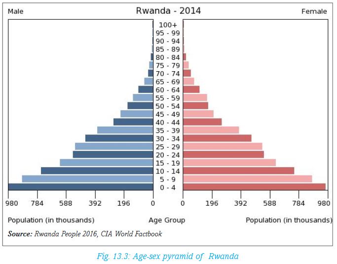 Notice that on the left are the males and on the right are the females. The longer the bar the higher the number of people within the given age group. This type of a graph is called an age-sex pyramid.
Activity 13.4
Use the graph above to answer the following questions:
1.a) Which age group has the longest bar?
b) What is the approximate number of people in this age group?
2.From 0 to 19 are people called dependants. Explain what dependants mean.
3.Which other group constitutes dependants?
The following are some of the conclusions that can be made from the pyramid above:
• The pyramid is broad at the base and gradually becomes narrow toward the top. This means that Rwanda’s population has a large number of young people.
• There are many children whose age is 0 to 4 years. This shows that the birth rate in Rwanda is very high. This is an indication of a population that is growing rapidly.
• A large part of the population of Rwanda consists of young people between 0 to 20 years. These are mainly children and the school going age who depend on their parents and guardians for all their needs.
• The old people who are over 70 years are few. From this age upwards, the people are not actively involved in economic activities. Like the young people, these are also dependants.
13.3 Population movements/migration in Rwanda (causes and effects)
a) Causes of population movements
Population migration is the movement of people from one place to another. Movement can be within the country (internal migration) or from the country to other parts of the world (external migration also termed as emigration). Movement can also be from other countries to Rwanda (immigration). Some of the movements are on permanent basis while others are temporary.
There are many reasons why people move from one place to another.
Activity 13.5
The following are factors that cause movements (or migrations) in Rwanda:
• Travelling for duty•Population pressure
• Search for employment opportunities
• Search for pasture and water
• Natural calamities
• Political instability
• Search for better health care and education
• Leisure/tourism•Go vernment policy
• Search for valuable resources
Use text books and other relevant resources on population to explain how each of the factors mentioned above may cause:
1. Internal population movements in Rwanda
2. External population movements in Rwanda
Explain some of the reasons that make foreigners to come to Rwanda.
Present your finding to the class for discussion
Effects of migrations
Activity 13.6
In groups, use text books and population documentaries to research on the positive and negative effects of:
i. Internal population movements in Rwanda
ii. External population movements in Rwanda
Discuss the findings for class presentation.
The areas where people are migrating from are affected in many different ways. Some of the effects are:
a) Depopulation: The areas which people move from may experience reduction in population if the movement involves too many people. This could lead to under- utilization of resources due to lack of enough labour force.
b) Reduced demand for local products: Due to the reduction in the number of people it could lead to a reduction in demand for goods and services.
c) Reduced skilled labour: If those moving out are the educated and skilled people, for example when professionals like teachers, doctors and engineers migrate, this causes a shortage of the skilled people. Rural areas in Rwanda experience lack of skilled people because many of the professionals are employed in towns.
d) Ease in population pressure: If people move out because of pressure on land, there will be sufficient land for those left behind. When people are few, the rate of environmental degradation reduces.
Activity 13.7
The following are positive and negative effects of migration. In pairs, read each point and classify each either as positive or negative.
(i) Pressure on amenities: The areas where people migrate to experience an increase in the population. This could lead to congestion and strain on social amenities.(
ii) Increased labour: The areas gets a large number of people with all skills that may be needed for different economic activities using cheap labour.
(iii) Higher levels of unemployment: Not all those who move to towns in search of employment are lucky to get jobs.Job opportunities do not increase as fast as population increase. Many people remain unemployed.
(iv) Increased market for goods and services: this is because demand increases with increased population.
(v) Development of informal settlements: Those who move to towns and fail to get employment are not able to afford good houses. They end up creating shanties to live in. This explains why there are slums in large towns. In such crowded areas, diseases spread easily.
(vi) Increase in crime rate: The unemployed turn to criminal activities to be able to survive. Some become drug dealers while some turn to prostitution.
(vii) Environmental degradation: When people migrate in large numbers to one area, they degrade the environment. It can be deforestation by people looking for building materials, it can be water pollution or soil erosion. Nyacyonga settlement scheme and Nyamirambo area in Kigali City are examples of areas where there has been environmental degradation.
13.4 Population growth and associated problems in Rwanda
a) Population growth
Population growth means increase in the number of people in an areas over a given period of time. Some of the reasons why Rwanda’s population grows so fast are:
(i) Improved healthcare and standards of living which has reduced death rates.
(ii) High fertility rates which means that the number of children born to one woman in Rwanda is high.
(iii) Migration into the country especially by Rwandans who were in exile during the 1994 Genocide against the Tutsi.
(iv) Cultural values where parents attach a high value to many children.
(v) Low levels of education which means that many people lack understanding of the importance of small families.
Activity 13.8
Case study
In Rwanda, the population was estimated to be 10.22 million in 2008. By 2010, it had grown to about 10.84 million. By 2012, it had increased to about 11.46 million and 11.34 in 2014. This shows that it is increasing. However, the land remains constant.
(Source: World Bank - October 7, 2016)
(i) Using the information above, calculate the percentage increase of population in Rwanda between.
• 2008-2010
• 2010-2014
• 2008-2014
(ii) What do you think will happen by 2050 if this trend continues?
(iii) Suggest measures that the government should take to control the population growth rate.
Problems associated with population growth in Rwanda
Rapid population growth in Rwanda has led a wide range of problems. These problems are not only felt by individuals but also by the government and country as a whole.
Some of these problems are:
• Pressure on land
Land for farming in Rwanda has become so scarce that people have encroached on to the forests and swampy areas. Others have settled on steep slopes like Gakenke where there are dangers of landslides. Others who are landless have migrated to towns in search of employment.
• Land fragmentation
The piece of land owned by a family keeps being subdivided over generations. Currently many family own very small pieces of land that cannot yield enough food for the members.
• Declined soil fertility
Cultivation on a piece of land is carried out year after year with little use of manure. This has caused soil exhaustion leading to low crop yields. In turn there is shortage of food.
• High expenditure by the government
The government spends large amounts of money to be able to provide social amenities such as health facilities, clean water, sufficient food and schools. These amenities are never enough. It is also difficult for the government to plan effectively for a rapidly growing population.
Activity 13.9
In groups,
1.Use available geographical documents and local environment to discuss the causes and effects of following problems of population in Rwanda:
(a) High levels of unemployment;
(b) Environmental degradation;
(c) Rural-urban migration.
2.Suggest possible measures to solve these problems
Prepare a report for class presentation.
13.5 Possible solutions to population growth in Rwanda
The problems of high population growth can be solved gradually. The government of Rwanda has been applying a number of measures to control the rate of growth. This is in realisation that in the years to come, the population will not have increased as rapidly as it has been. Measures applied include:
a) Introduction of family planning programmes
The government has been advocating for family planning so that each family can only get the number of children it is able to raise without straining. This has been done first by raising awareness in public health institutions and public meetings. Once people are convinced, they are educated on the use of contraceptives and other ways of controlling births.
b) Discouraging early marriages
This has gradually been achieved as more people appreciate the value of education and take their children to school. This has helped to delay the time girls are married off. The older and more educated they are the fewer the number of children they are likely to get.
c) Advocating for small families
There has been widespread public awareness on the advantages of small families.
d) Discouraging prostitution
Prostitution is a bad practice that should be totally eradicated in the society. It leads to unwanted children as well as spread of sexually transmitted diseases such as HIV 163163and AIDS. This is discouraged because the children who are born become a burden to those left to look after them and to the government.
Activity 13.10
1. In pairs, complete the table below and discuss your findings with the rest of the class.

2.Which family would you prefer and why?
13.6 Impact of early sex, health risks, HIV and Aids, STDs in Rwanda and possible prevention measures
It is wrong to get involved in sexual affairs at an early age. It is not healthy and has many risks some of which can lead to death.
Activity 13.11
With the help of your teacher, invite a health worker to give a talk on health risks related to early sexual affairs.
In groups, use the knowledge gained from the talk by the health worker and relevant resources to research and write a essay on:
The effects of early sex, health risks, HIV and AIDS and STDs in Rwanda.
1.Suggest possible measures that can control the trend.
Present your report for class discussion.
13.7 Possible prevention measures to the impact of early sex, health risks, HIV and AIDS and STDs in Rwanda
Some measures that have been put in place are:
(i) Giving comprehensive knowledge to young people on preventive measures against STDs is very important. The most effective measure is to change ones 164164behaviour so as to avoid engaging in sex and other behaviour that could lead to contracting the diseases.
(ii) Introducing topic on STDs as one of the subjects taught in schools so as impart the knowledge at an early stage in life.
(iii) Establishing more health care centres in the country and encouraging people to go for testing to know their status and keep off bad behaviour. Rwanda has a centre called Centre for Control and Prevention of diseases where some of the preventive services are offered.
(iv) If a young pregnant mother is found to be infected, measures should be taken to ensure that the unborn baby will not be infected.
Activity 13.12
1.Research more on the prevention measures that have been put in place in Rwanda regarding the impact of early sex, health risks, HIV and AIDS and STDs.
2.Make a class presentation.
13.8 Demographic problems in Rwanda and their solutions
Demography is the study of population.
Like many African countries, Rwanda’s population is faced with many problems. However, the government is doing everything possible to solve these problems. Some of the measures the government is employing are included in the table below.
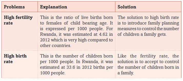
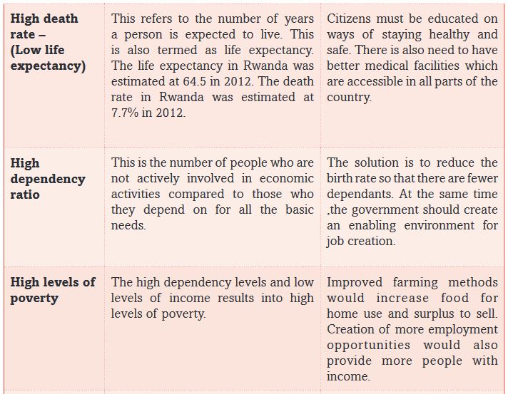

END OF UNIT REVISION EXERCISE
1. Identify and explain the factors influencing population distribution and density in Rwanda.
2. Describe the population structure of Rwanda.
3. Explain the causes for population movements in Rwanda.
4. Outline the reasons for rapid population growth and state the effects.
5. Suggest ways through which Rwanda can control the population growth.
6. Explain the impact of early sex, health risks, HIV and Aids and STDs.
7. Suggest the various ways of preventing the spread of these diseases in Rwanda.
8. Describe the demographic problems in Rwanda and for each suggest possible solutions.
Unit 14: RURAL AND URBAN SETTLEMENT IN RWANDA
Key unit competence
At the end of this unit, you should be able to explain the impact of rural and urban settlement on the sustainable development of Rwanda.Introduction
Settlement refers to how people live and carry out their economic, political, religious and social activities. There are two basic categories of settlements. These are rural and urban settlements.
The following illustration shows how settlement in Rwanda is classified:
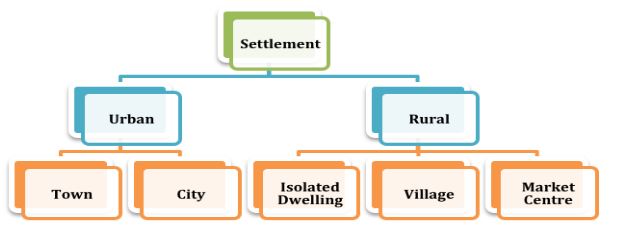
In this unit, we will discuss the following key sections under each type of settlement:Rural settlement
• Types of rural settlements: grouped, nucleated, linear, isolated and planned
• Characteristics of rural settlements
• Problems and solutions of affecting rural settlements
• Advantages and disadvantages of rural settlement schemes (Imidugudu)
Urban settlement
• Major urban centres in Rwanda
• Major characteristics of urban settlement
• Factors influencing the growth of urban centres in Rwanda
• Problems faced by urban centres in Rwanda and their possible solutions
• Environmental protection measures in urban centres in Rwanda
Activity 14.1
In groups, discuss reasons why people choose to live in certain places in the rural areas.Present your findings in class.
14.1 Rural settlement in Rwanda
14.1.1 Types of rural settlements
Activity 14.2
Study the photographs shown below then answer the questions that follow.

1.Describe how people are settled in the top right part of photograph. How different is this type of settlement from the rest of the area shown by the photograph?
2.Discuss the possible reasons that explain settlement patterns in the area shown by the photograph.
There are five types of rural settlements in Rwanda. These are:
• Grouped settlement
• Nucleated settlement
• Linear settlement
• Isolated settlement
• Planned settlement
i) Grouped settlement
Grouped settlement in Rwanda is also called Umudugudu. This is a mode of settlement having between 100 and 200 mud-bricked houses in an area. It is a low-cost housing scheme, to resettle thousands of people who returned after the 1994 Genocide against the Tusti.
This type of settlement is organised into centres of development, equipped with basic infrastructure and services. This system serves as the starting point of development of non-agricultural income generating activities. Land is reorganised and consolidated so as to create adequate space for modern living. This reoganisation also allows for profitable farming.
Several grouped settlements make up Rural Settlement Schemes.
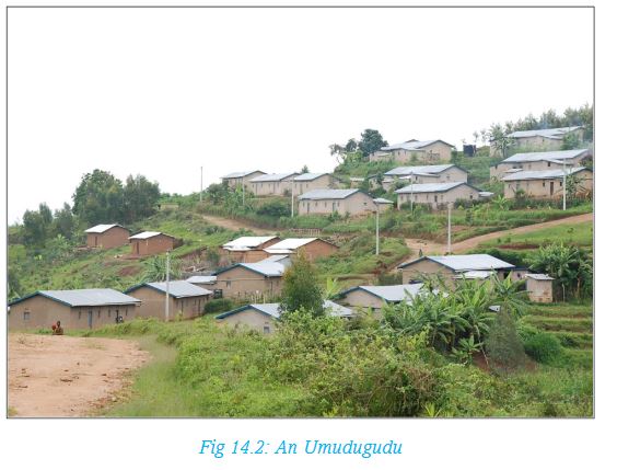
Remember!
The aim of Umidugudu in Rwanda is to provide improved quality of life for the population. This is achieved through provision of basic needs such as:
• Employment
• Adequate housing
• Access to water and energy
• A cleaned-up environment
• Access to basic facilities such as markets and health services
• Safety and order in public places and in homes
Activity 14.3
Identify three areas in your locality where there are imidugudus. List the distinguishing characteristics of the places you have identified from other settlement patterns.
ii) Nucleated settlements
Nucleated settlements are clustered together round a nucleus such as route junctions or where a given resource is being extracted. The settlements are either permanent or temporary. They are often linked by roads or footpaths. This is type of settlements is common in Muhanga and Rulindo districts.
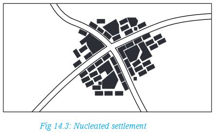
iii) Linear settlements
Activity 14.4
Study the following photograph then state reasons that have influenced the type of settlement shown.
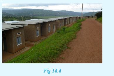
A linear rural settlement pattern forms along a river, coastline or road.The pattern takes the shape of the feature which could be a straight line or curved. The pattern is likely to be maintained even when the population grows.
iv) Isolated settlements
In isolated settlements, dwellings or homes are far apart. Isolated settlements occur where land is owned individually and every family settles on its piece of land. It is common in areas with low agricultural productivity and therefore there is low population density. It is also common in areas with little or no rainfall. Many places in Kayonza and Nyagatare districts have isolated settlements.
Activity 14.5
1. Draw an illustration to show isolated settlements.
2. Give examples of places in Rwanda that have isolated settlements.
v) Planned settlements
Planned settlements in Rwanda originated from The National Human Settlement Policy,adopted in December 1996. The policy focuses on urban planning, restructuring of unplanned residential areas in towns and the regrouping of the rural population.
Planned settlements were introduced to settle Rwandans who:
• Were relocated from high-risk zones
• From historically marginalised groups
• Were evicted from Tanzania
• Came from Mugombwa refugee camp
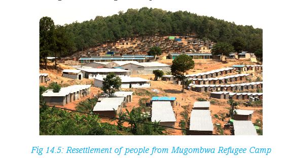
The aim of planned settlements is to ensure that every Rwandan has access to water, roads electricity and infrastructure facilities. Planned settlements are already in place in Huye and Gisagara, including Save, Gisagara and Kibirizi.
Remember!
Planned settlements prioritise the planning and development of improved rural and urban human settlement. This has a double effect of providing decent housing as well as ensuring better land use and environmental protection.
14.1.2 Characteristics of rural settlements
Activity 14.6
There are five categories of rural settlements as discussed above.
Fill the table below with characteristics of each type of settlement discussed above.
Most rural area settlements consist of scattered homesteads and other buildings that are far apart. They may be separated by ridges, hills or rivers. They are also common where extensive farming is practised. Rural settlements are characterised by single farms and nucleated villages. Majority of inhabitants of rural settlement are involved in agriculture and primary activities like fishing, farming, forestry and mining. The pattern of rural settlement varies from a single farm to a cluster of houses. This is determined by the resource present and type of land use.
14.1.3 Problems affecting rural settlements
Activity 14.7
Study the following photo of a typical rural settlement.
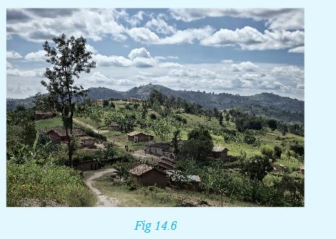
From the photograph, explain some of the challenges that people living in such an area are likely to face. Base your discussion on the following points:
a) Availability of electricity
b) Good roads
c) Source of water
d) Ease of trade
e) Ability to carry out farming
f) Presence of social amenities such as schools and hospitals
Rural settlements experience the following problems:
i) Inadequate basic social facilities for the population.
ii) The rural to urban migration results to shortage of labour in the farms.
iii) Deteriorating soil fertility due to poor farming methods that has caused decline in agricultural production.
iv) Encroachment onto forested areas reducing the forest cover.
v) Few income generating activities leading to increased poverty levels.
14.1.4 Solutions to the problems affecting rural settlements
i) Establishing regrouped settlements through imidugudus.
ii) Improving the basic infrastructure and services such as water supply, electricity supply, transport and communication, health and education services.
iii) Improving agricultural production that is the mainstay of the economy of Rwanda.
iv) Initiating the creation of other income generating activities other than agriculture by working with private development partners to empower communities financially.
v) Initiating training architectures on low cost alternative building materials to save forests.
vi) Implementing the The National Policy on Human Settlement that provides for the control of unplanned rural settlements. It also provides for consolidation of rural settlements with basic infrastructure.
vii) Initiating plans to develop inclusive settlement with priority to the vulnerable such as the women, youth, the disabled and those living with HIV and AIDs. This will be done in collaboration with development partners. Specifically, women will be trained in entrepreneurship and management of decent economic activities.
14.1.5 Advantages and disadvantages of rural settlement schemes (Imidugudu)
Advantages of rural settlement schemes (Imidugudu)
1.It led to the construction of many houses for survivors of the 1994 Genocide against the Tutsi.
2.Since the policy focused on group settlement, the government managed to solve the problem of land scarcity.
3.Imidugudu targeted the establishment of specific residential areas in each village in efforts to enhance proper land utilisation
4.Through such an initiative, the government has been able to provide the basic services to a larger section of the population. This is because people would be concentrated in defined areas, making it much easier and more efficient to provide social and economic services such as health, education, water and sanitation to the population.
5.Such settlements enabled people to mobilise self-defence units against gangs of militiamen that still roamed the countryside after the 1994 Genocide against the Tutsi.
6.Communities in the Imidugudu provide mutual support and foster trust amongst themselves.
Disadvantages of rural settlement schemes (Imidugudu)
a) Some of the housing units were hurriedly constructed compromising the building standards of the houses.
b) The size of the land available per household is less than one hectare and the space for agricultural activities is about half a hectare. This limits the available land for agriculture. In some cases, this has forced some people to move kilometres away to access land for cultivation.
c) In some cases, areas of flat land were chosen, making housing construction easier. However, the land was often fertile agricultural land, which forced those affected to use less fertile hill slopes for cultivation. This led to low crop yields and environmental degradation.
d)In some Imidugudu, such as the ones in Nyagatare, people walk at least 35 km to the nearest health centre. Children in Ngoma on the other hand live 20 km from the nearest school.
14.2 Urban Settlement
14.2.1 Major urban centres in Rwanda
Urban centres are spread in all the five provinces. The major cities are headquarters of the provinces or districts.
Activity 14.8
Below is a map marked with major urban areas. Use your atlas to name all the urban centres shown on the map.
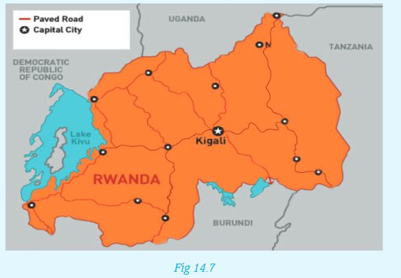
14.2.2 Major characteristics of urban settlement
Activity 14.9
Discuss:
Explain the distinguishing characteristics of an urban area.The Rwandan cities share the following common characteristics:
i) Agriculture is the main economic activity except in Kigali.
ii) They are residential, commercial and administrative centres.
iii) They have high traffic congestion especially during rush hours.
iv) Urban centres are route focused, that is, they are centres of communication.
v) They have high population compared to rural areas.
vi) Settlements range from high cost housing units to low cost housing.
vii) They are built–up areas with tall buildings.
14.2.3 Functions of urban centres in Rwanda
a) Functions of Kigali City
i.It is an administrative centre, and serves as the national capital. The main residence and offices of the President of Rwanda are located here. Offices for various Government Ministries are also found here.
ii.It is a residential centre with different classes of residential zones.
iii.It is a transport and communication centre. It is a focus of roads and has an International airport.
iv.It is a financial centre, with major banks and insurance companies such as Bank of Kigali, Equity Bank, Kenya Commercial Bank, and Soras Insurance Company.
v.It is a recreational and cultural centre with museums, national stadium, several hotels and clubs.
vi.It is an educational centre with several primary and secondary schools, universities and institutions of higher learning. Such institutions include College of Education, College of Business and Economics and University of Rwanda (which has over three campusses).
b) Functions of Huye
i.It is an administrative centre.
ii.It is a residential centre.
iii.It is a transport and communication centre. It is a focus of roads and has an airport.
iv.It has Murambi Genocide Memorial.
v.It is an educational centre, with primary and secondary schools. For instance, it houses the University of Rwanda and Rwandan National Institute of Scientific Research.
c) Functions of Rubavu
i.It is a residential centre.
ii.It is an administrative centre.
iii.It is a transport and communication centre.
iv.It is a recreational and cultural centre with museums and several beach hotels.
v.It is an educational centre with primary and secondary schools, including the National University of Rwanda.
d) Functions of Musanze
i.It is an administrative centre.
ii.It is a cultural centre with several learning institutions such as Muhabura Polytechnic and Institute of Applied Science.
iii.It is a business and trade centre.
iv.It is a residential centre.
v.It is a major tourist destination for watching the unique mountain Gorillas, excavated caves with early humans and Eco gardens.
vi.It is a recreation centre with many hotels and clubs
14.2.4 Factors influencing the growth of urban centres in Rwanda
Activity 14.10
Several factors have led to the growth of cities and towns in Rwanda. Some of these factors are:
a) Historical issues
b) Economic activities
c) Transport and communication
d) Administrative activities
e) Human migration
f) Natural growth of urban settlements
Using Kigali City as a point of reference, discuss with examples how each of the above factors has contributed to its growth.
14.2.5 Problems facing urban centres in Rwanda and their possible solutions
Activity 14.11
Use the local urban centres to observe and record the problems of urban growth and the control measures.
In groups, discuss the findings and make a class presentation.
The following table presents a summary of the problems facing urban centres in Rwanda.
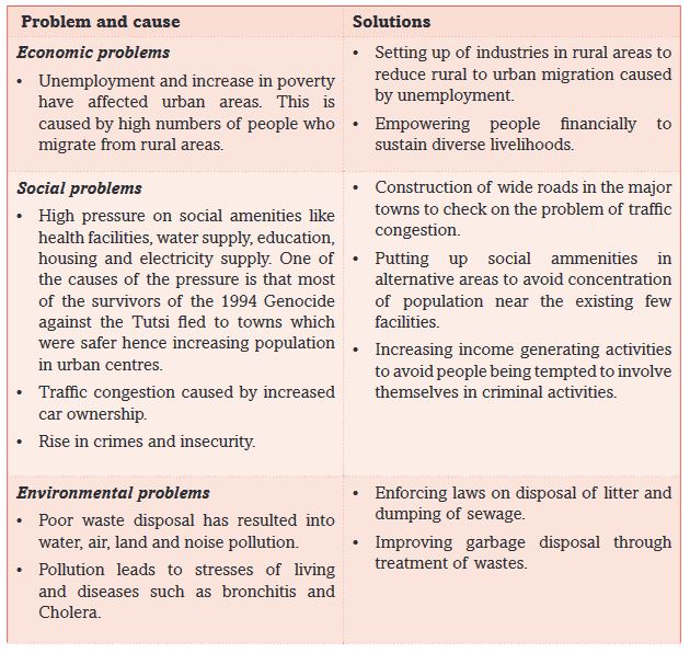
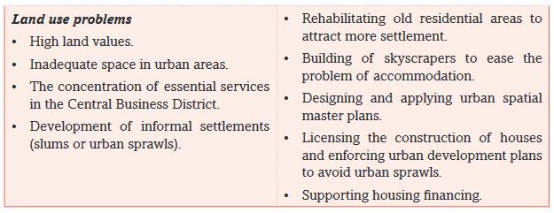
Remember!
Practice of solid waste disposal in landfills presents serious environmental concerns such as vegetation damage and unpleasant odours.
14.2.6 Environmental protection measures in urban centres in Rwanda
Activity 14.12
Using the Internet and other geographical sources of data, research on the environmental protection measures in urban centres in Rwanda. In groups, discuss the findings and make class presentation.
The development of slum has been a major concern to the government. The following are some of the solutions initiated:
i) Creating jobs in the smaller cities of Huye, Rubavu, Nyagatare, Rwamagana, Rusizi and Musanze. This is expected reduce migration to the capital of Kigali.
ii) Training people in technical and vocational skills to enable them take part in the construction of more housing units needed in the cities.
iii) Identification of the right raw materials for construction and right technology to promote low-cost indigenous home building.
iv) Expanding the sewerage system in line with increased population. Regular garbage collection and disposal to be out of town. Garbage treatment is undertaken far from towns.
v) Extending social services to rural areas to limit rural-urban migration.
vi) Providing enough security in urban centres to suppress crime.vii)Constructing new roads, highways and expanding existing ones to ease traffic congestion.
END OF UNIT REVISION EXERCISE
1. What is the meaning of the following terms?
• Settlement
• Land use
• Urbanisation
2. Give three characteristics of rural settlements.
3. Study the photograph provided and answer the following questions.
(a) Explain the problems that people living here may be facing.

(b) What is housing shortage?
(c) What are inclusive homes?
4. How does urban growth help in developing rural areas?
5. Write four functions of Kigali city.
6. Explain four efforts the Government of Rwanda has made to improve rural settlements.
Unit 15: AGRICULTURAL SYSTEMS IN RWANDA
Key unit competence
At the end of this unit, you should be able to investigate the impact of various agricultural activities on sustainable development in Rwanda.Introduction
Economic activities refer to what people do to get money. Agriculture is one of the main economic activities people carry out in Rwanda. Other activities are trade, forestry, mining and fishing.
Agriculture involves crop farming and animal keeping. It generates more than 70% of the country’s export revenues. Many people are employed in the agricultural sector.
The size and quality of agricultural land determines the type of agriculture people practise. The large farms or plantations are used for growing crops for sale. Such crops are sugarcane, tea and coffee. On small parcels of land, a variety of crops is grown and animals are kept mainly for home needs. This is referred to as mixed farming.
Activity 15.1
Carry out a field study around the school to find out:
• The type of crops people grow
• The type of animals people keep
• The average size of their farm
• The source of the water they use on their farms
Present your findings to the class for discussion.
15.1 Types of agricultural systems in Rwanda
From Activity 15.1 above, you will discover that people practice different types of agriculture. These systems include:
• Subsistence farming
• Commercial farming
• Irrigation farming
15.1.1 Subsistence farming
Activity 15.2
Some people around your school or home plant some crops to be eaten at home.In your notebook, indicate products that are for sale, home consumption or both.For the crops that are for home consumption, classify them as follows:

Farmers who grow crops for home consumption practice subsistence farming. This is practiced by a majority of farmers in Rwanda. This is a system of farming in which the farmer grows enough food to feed themselves and their families. The plots of land are small. These farmers often store their produce until the next harvest. Farmers use simple tools. Where facilities like electricity and irrigation are available, farming has improved. The main food crop is bananas. Other crops are sweet potatoes, peas and beans, cassava, melons, sorghum and peanuts. Subsistence farming also includes keeping of domestic animals such as cattle and goats to supplement the crops.
15.1.2 Commercial farming
This is where farmers grow crops or raise animal for sale. Farmers sell the crops and animal products to earn income. Crops grown on large scale for sale are called cash crops. They include coffee and tea. In this system, the machinery substitutes for the labour of humans and animals. Unlike subsistence farming, some of the crops are grown on large scale and animals too are kept in ranches. This provides a supply of the products to industries for processing.
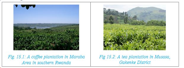
Read Further!
Carry out a research from the Internet, textbooks or other geographical documents to get the characteristics of commercial agriculture in Rwanda. Present your findings to the class.
15.1.3 Irrigation farming
In areas that receive unreliable rainfall, irrigation farming is practised. Irrigation refers to the application of water to the land or soil. It is used to help in the growing of crops during periods of inadequate rainfall.
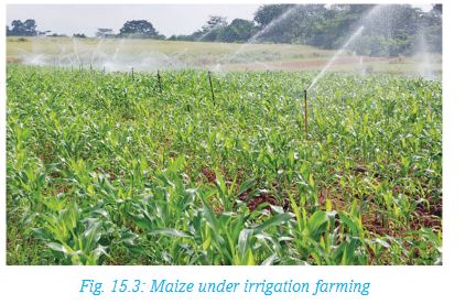
Irrigation is important because farmers increase agricultural productivity through allowing several cropping and reducing effects weather changes.
Activity 15.3
Find out in groups of five the types of crops grown under irrigation in Rwanda. Identify the areas where this type of farming takes place. For each area, name the source of water.
15.2 Major crops produced in Rwanda
Generally, Rwanda has favorable climatic conditions. The fertile soils in the country allow cultivation of a wide range of crops.
The crops grown in Rwanda are mainly food crops and cash crops.The main food crops include maize, beans, rice, bananas, Irish potatoes, sweet potatoes, cassava, groundnuts, sorghum and beans. Bananas that are grown are cooked, eaten when ripe or used in making beer.Vegetables such as onions, cabbages and eggplants are also widely grown.
The main cash crops grown in Rwanda are tea and coffee. Together, tea and coffee make up a bigger percentage of the country’s agricultural exports.
Barley for beer and green beans are also grown as cash crops. Two-thirds of Rwanda’s farmers grow beans. In the marshier areas, rice is becoming important.
15.3 Livestock farming
Livestock faming is the keeping of animals. Animals kept on a larger scale are mainly for sale. Those kept on a small scale are usually meant for domestic consumption.
There are two types of livestock farming. These are:
a) Traditional (or subsistence) livestock farming
b) Commercial livestock farming
15.3.1 Traditional (or subsistence) livestock farming
Traditional (or subsistence) livestock farming is where farmers keep the livestock primarily for family consumption. Products include eggs, milk, meat and honey.
15.3.2 Commercial livestock farming
In commercial livestock farming, products are mainly for sale.
Activity 15.4
Study the photographs of livestock provided.
1. In groups,discuss the characteristic of each type of farming.
2. Write the similarities and differences in the types of farming shown.
3. Outline the advantages and disadvantages of each type of farming.
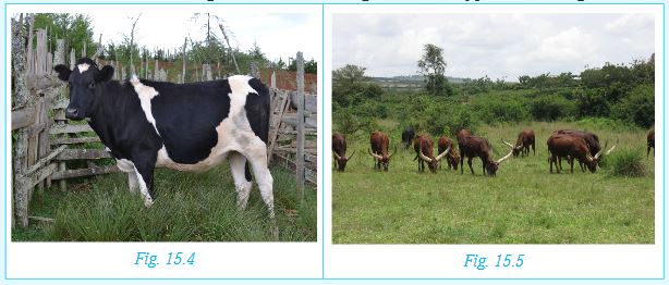
Livestock farming is further divided into ranching and dairy farming.
15.3.3 Ranching
Ranching is a method of farming where livestock is reared in extensive farms.
15.3.4 Dairy farming
Dairy farming on the other hand is a type of farming where the cattle are reared for milk production.
Characteristics of ranching and dairy farming
Characteristics of dairy farming
• Animals are kept mainly for production of milk.
• It can be in small or large scale.
• Most small scale dairy farmers practice zero grazing where animals are kept in an enclosure and provided with feeds and water.
• Large scale dairy farming involves keeping animals in open grazing fields divided into paddocks.
• The main dairy cattle breeds kept are Friesian, Jersey, Ayrshire and Guernsey.
• Dairy farming is carried out in areas that have good transport facilities and ready market for the milk.
• Farmers grow fodder crops and also use manufactured feeds to boost milk production.
• Reproduction is facilitated through artificial insemination.
• Animals are well cared for to avoid attacks by parasites and disease.
Characteristics of ranching
• Animals are kept mainly for production of meat and for sale.
• Animals graze on natural pastures in the ranches.
• The ranches are supplied with sufficient water.
• The ranches are divided into paddocks to ensure availability of pasture throughout.
• The animals are protected against diseases through spraying or dipping in chemicals to remove ticks and other parasites that could cause diseases.
• Cross breeding is done to improve the quality of the animals.
15.4 Problems and solutions of agriculture in Rwanda
(i) Problems facing dairy farming in Rwanda
Activity 15.5
In groups, discuss how each of the following factors hinder the development of dairy farming in Rwanda.
• Climate
• Size of the population
• Pest and diseases
• Market
Present your findings for class discussion.
Factors that hinder the development of dairy farming in Rwanda are:
a) Frequent droughts, which reduce pasture and water for the cattle.
b) Animals are at times attacked and killed by diseases such as Nagana which is transmitted by tsetse flies.
c) The exotic breeds reared are expensive to keep particularly during the dry season.
d) Ranching requires skilled labourers that may not be readily available.
(ii) Ways of improving livestock farming in Rwanda
Activity 15.6
In groups, discuss:
1. The meaning of value addition in livestock rearing.
2. How keeping of one type of livestock can be a way of improving livestock farming in Rwanda.
The following are some of the ways livestock farming in Rwanda is being improved.
a) The government has made effort to improve livestock farming. One way of improving livestock farming is by educating farmers on better ways of taking care of livestock.
b) Demonstration farms have been established to train farmers on modern methods of livestock farming. Other support services include teaching farmers how to control livestock diseases. In addition, they are taught how to get money from the government, banks or cooperatives to support their farming.
c) Effort has been made to cross-breed local animals with imported breeds. This is to produce quality products for the market. The government has also constructed valley dams and boreholes to reduce water shortages. Farmers are encouraged to grow alternative feeds with high nutritive value for the livestock.
d) To promote commercial livestock farming, farmers have been educated on adding value to products to gain higher profits.
e) Better storage facilities have also been established.
f) Transport and communication networks are always being improved and have also been expanded to enable quick transportation of products to the market.
(iii) Keeping of small animals
Activity 15.7
In pairs, identify small animals that are kept in most homes in Rwanda.
List the products obtained from these small animals.
Small animals that are commonly kept in homes include pigs, goats, sheep, rabbits, chicken and bees. The keeping of small animals is increasingly being taken up by farmers. This is because they are cheaper to keep. They also provide a quick source of income.
Factors affecting the keeping of small animals
a) Favourable climate: Livestock such as goats, hens, pigs and rabbits survive in a wide range of climate.
b) Relief: Areas of high relief such as those in the western side of the country favour the rearing of such animals as pigs. The drier areas on the eastern side of the country favour bee keeping.
c) Government policy: The government has undertaken a number of steps to support the rearing of small animals in Rwanda. These include facilitating extension services, providing subsidised farm inputs and ensuring good roads for transport of animal products.
d) Traditions of the people: Many Rwandans have always had one or more animals kept at home.
e) Land: As population increases, the available land for agriculture keeps on shrinking. This has forced many people never to the keeping of small animals.
f) Availability of pasture: Small animals need a small piece of land for pasture. Some of them survive on the leftovers at home.
Activity 15.8
In groups:
a) Explain how the following factors have affected livestock keeping in 5wanda:
Climate
Government policy
Cultural beliefs
Availability of land
b) Give reasons why agriculture is important to the economy of Rwanda.
Problems and solutions of agriculture in Rwanda
The following table shows how some of the problems facing agriculture in Rwanda can be solved.
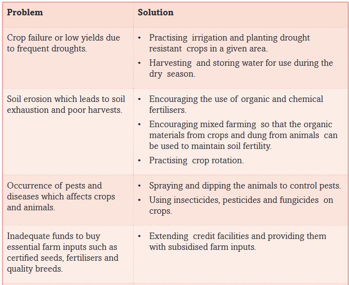
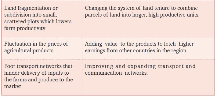
15.5 Agriculture modernisation
Activity 15.9
Fieldwork
1. Visit a nearby farm. Observe and record the following:
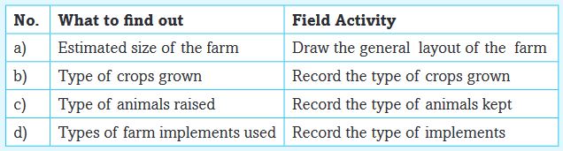
2. Write a paragraph explaining if the type of agriculture you observed is modern of traditional.
Present your findings for discussion.
What is modernising agriculture?
Activity 15.10
Be smart, build your knowledge!
Read the following words.Using the dictionary and Internet Sources,get the meaning of the following terms as used in agriculture. Write the meanings in your notebook.
Soil weakening, poverty, food security, malnourishment, food shortage, food reserves, nutritious foods, extension services, early warning, irrigation, soil nutrients, weather changes, trade, family income.
Most people in Rwanda depend on agriculture. Despite agriculture being the main source of income to many,some farmers still practice traditional subsistence farming.This method is unproductive,and dependents on family labour.Food shortages and malnutrition in some areas is worsened by adverse weather changes. Such practices can neither sustain the national food and nutritional requirements,nor its economy.
15.5.1 Measures put in place by the government to modernise agriculture
These include:
a) Combining and reorganising the fragmented pieces of land into productive units.
b) Using modern machinery and equipment during land preparation. There are machines and equipment that can also be used during the growing period of the crops. Generally, use of farm equipment and machinery reduces dependence on human labour. For instance, tractors are used on large farms in areas such as Nyagatare and Kayonza.
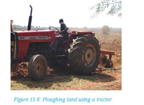
c) Planting certified seeds and using cuttings and plant tissues that are high yielding varieties.
d) Planting drought resistant varieties of crops to minimise chances of crop failure.
e) Engaging in commercial farming as opposed to subsistence farming.
f) Using better soil management practices such as adding manure or using plant remains as a mulch to conserve soil nutrients and moisture.
g) Using natural means, pesticides and fungicides to control crop and animal diseases.
h) Improving transport and communication to help people access markets faster.
i) Reducing reliance on rain-fed agriculture to farm in all seasons. This is by storing water in dams and harvesting rain water for use during the dry season.
j) Increasing investments and financial services to the farmer.
15.5.2 Factors favouring implementation of modernised agriculture
• The government supports the implementation of agricultural modernisation by:
- Training farmers regularly on agricultural management, value addition and entrepreneurial skills.
- Working with private investors to fund agricultural enterprises.
- Improving the spread of information on agricultural commodities and their prices through low cost methods such as the use of mobile services.
- Supplying inputs to farmers such as fertilisers and improved seeds, and farm equipment at subsidised prices.
- The government has employed more extension workers to assist farmers.
- Training farmers on the best practices from traditional agriculture to enhance modernised agriculture.
• The increase of population in Rwanda has created a ready market for agricultural commodities.
• There has been improved information on changes in weather.
• Research on agriculture has been intensified and results shared with farmers.
• Currently, farmers can get loans and financial advice through cooperatives.
Activity 15.11
In groups:
1. Describe the reasons for modernisation of agriculture in Rwanda.
2. Explain the advantages and disadvantages for modernisation of agriculture in Rwanda.
Write down the findings for class presentation. Engage in a question and answer session.
15.5.3 Advantages of modernised agriculture
The advantages of modernised agriculture are:
(i) Communities grow crops, rear animal and engage in business to build better lives.
(ii) The high yields from different types of farming has led to an increased production of food for all people.
(iii) There is increased employment opportunities especially in the rural areas.
(iv) Women and the young people make up a high percentage of population in rural areas. They supply a significant part of labour to the various forms of agriculture. Modern agriculture has created commercial opportunities for them. By earning income, poverty is reduced.
(v) Modern agriculture has increased the production of raw materials for industries.
(vi) Modern transport and storage facilities helps to reduce wastage.
(vii) The country earn foreign exchage from the export of agricultural commodities.
15.5.4 Disadvantages of modernised agriculture
There are several disadvantages of modernised agriculture. Some of these are:
• The use of chemical fertiliser has negatively affected the environment. For example, during the rainy season, excess fertilisers are washed down from farmlands into water bodies such as lakes. This leads to the growth of weeds in these water sources.
• The use of pesticides kills some useful insects.
• Modern farming requires a lot of water particularly to irrigate the land. This may affect the availability of water for other uses.
• The use of certified seeds and new animal breeds may in the long run cause a decline in the original (traditional) plants and animal species.
• A lot of funds are required to support modern agriculture.•Intensive commercial farming and monoculture in large plantations causes impoverishment of soil.
15.6 Impact of agriculture on sustainable development of Rwanda
Sustainable development refers to development that meets the needs of the present without affecting the ability of future generations to meet their own. In agriculture, farming systems that are consistently productive and useful to the society over a long time are said to be sustainable. Such farming systems use environmentally appropriate practices that conserve the soil. The produce is able to support the population and contribute meaningfully to the income at household level. This is also beneficial to the government as it is a source of revenue.
Agriculture is important in the development of Rwanda because of the following reasons:
• The country is able to provide adequate food for the people. It also enhances the quality of life for farmers and the society as a whole.
• Agriculture helps to make the most efficient use of non-renewable resources such as soil and other on-farm resources.
• The revenues enables the government to provide education, primary health and clean water services to its citizens.
Activity 15.12
In groups:
Discuss other reasons why agriculture is important in the sustainable development of Rwanda.
Record your findings for class presentation.
15.7 The advantages and disadvantages of plantation farming in Rwanda
Plantation farming refers to large scale growing of a single crop purposely for sale. This is called monoculture. In this type of farming,scientific methods are used. Most of the crops grown on plantation in Rwanda are perennial crops such as tea and coffee. With the temperate climate and plentiful rain and sunshine, the slopes are perfect for growing tea. Together, tea and coffee make up a large percentage of the country’s agricultural exports. Barley for beer and green beans are also grown as cash crops.
However, the steep slopes and acidic soils of Rwanda’s highland areas make them unsuitable for growing food crops. Two thirds of Rwanda’s farmers grow beans. In the marshier areas, rice and sugarcane are widely grown.

Activity 15.13
In groups of five, explain the advantages and disadvantages of cash crops growing in Rwanda.
Advantages of plantation agriculture
There are several advantages of plantation agriculture. Some of the advantages are:
a) With the high level of mechanisation, productivity is also high.
b) The specialisation in production process leads to high quality products.
c) Plantations produce cash crops which provide export earnings.
d) Plantation agriculture employs a large number of labourers, both skilled and semi-skilled.
e) Plantation farming encourages industries that process the agricultural raw materials.
f) Plantation agriculture provides market for agricultural machinery.
g) On some plantations, infrastructure such as roads, water supply and electricity have developed. Plantation owners may also provide schools, houses and hospitals for the workers.
h) Some plantations are research and demonstration centres for a wide range of crops.
Disadvantages plantation agriculture
• Plantation agriculture requires heavy investment to grow, process and transport the crop to the market. Therefore, it is expensive to start and maintain.
• The cash crops use up land that could grow food for the local population.
• Natural disasters such as drought, floods, pests and crop diseases may affect the crops leading to heavy looses.
• Monoculture exhausts the soil if it is not well managed.
• Plantations are often affected by fluctuation of prices on the world market.
END OF UNIT REVISION EXERCISE
1. Explain the meaning of “commercial livestock farming.”
2. Give reasons why farmers in Rwanda should keep small animals at home.
3. Discuss the contributions of livestock farming in Rwanda.
4. Explain the major characteristics of dairy farming in Rwanda.
5. Describe the problems affecting cattle keepers in Rwanda and give the solutions to these problems.
6. Explain the meaning of the term “agriculture modernisation.”
7. Suggest the ways of transforming agricultural practices in Rwanda.
Unit 16: FORESTRY IN RWANDA
Key unit competence
At the end of this unit, you should be able to investigate the impact of various forestry activities on sustainable development of Rwanda.Introduction
Forestry involves developing, caring and exploiting valuable forest products. Forestry is a primary activity. It is an important activity because it enables us to not only plant and care for forests and the environment but also through forestry we obtain fuel and raw materials for building and construction. Through forestry we are able to use forests sustainably.
16.1 Definitions of forest, forestry and silviculture
Activity 16.11.
Using a dictionary and other geographical sources, write down the meaning of the following words:
i. Forest
ii. Forestry
iii. Silviculture
iv. Agroforestry
2.Differentiate between natural and planted forests.
Planting trees in an area where a forest has been destroyed is referred to as reforestation. This is like repairing a forest that is worn out. Planting trees in a place that had no forest before is referred to as afforestation.
Activity 16.2
Identify the forested areas around your school and write a paragraph describing the distribution and characteristics of the forest within the local environment.
Share your findings with the rest of the class.
Rwanda lies at the Equator. The country receives high rainfall that is able to support large forests. Originally when the population of Rwanda was very small, most of the country was covered with forests. For example it is estimated that in 1960 the area under forest was about 6 340km². By 2010 this had reduced to 2 575 km² including planted forests. As the population increases, demand for land for cultivation increases and this has led to the decline of the land under forests. Nowadays, only about 20% of the total area is under forest part of which is under protection.
(Source: REMA, 2015)
Activity 16.3
1. Use a map of Rwanda showing vegetation, geographical documents and Internet to research on different forest areas and types of forests in Rwanda.
2. Come up with a list of major forests in Rwanda.
Present your findings for class discussion.
16.2 Types of forests and major forest areas in Rwanda
There are two types of forests in Rwanda. There are natural forests and planted forests.
The natural forests
These are found in the protected reserves which are in places that have not been affected by very serious exploitation. The largest natural forest in Rwanda is Nyungwe Forest.

Natural forest reserves are the typical tropical rain forests which are evergreen. They are characterised by hard wood trees consisting of many different species. The trees have straight trunks and grow in layers with the tallest ones exceeding forty metres in height. Branches of different trees extend into each other to form a continuous canopy that prevents sunshine from reaching the ground level. Where the canopy is open there is thick undergrowth. Unlike the tropical forests, the vegetation in the Volcanoes National Park is characterised by bamboo forests due to the high altitude.
Other natural forests are the savanna woodlands found in small patches in such areas as the Akagera National Park and Busegera in the eastern parts of the country and riverine forests along some of the main river valleys.
Activity 16.4

1. Use the map of Rwanda above to identify natural forests reserves in Rwanda.
2. Explain measures that the government of Rwanda has put in place to protect natural forests.
Planted forests
Notable quote:
“Most people know that forests are the lungs of our planet, literally playing a critical role in every breath we take. And that they are also home to incredible animals like the colobus monkeys and elephants, which will go extinct if we keep cutting down their forests.” – Chris Noth.
Activity 16.5
Read the article below.
Rwanda marks Tree Planting Day by planting 30,739,957 seedlings in afforestation and reforestation effort.

Rwanda marked the 39th Tree Planting Day by beginning to plant 30,739,957 seedlings around the country, as part of the National Tree Planting Season. This event was held under the theme “Enhancing climate change resilience through agroforestry” and recognises the role played by forests in the restoration of ecosystems and in enhancing climate change resilience.
The official ceremony to mark the National Tree Planting Day and launch the tree planting season took place in Rubavu District, Kanama Sector, whereby participants took part in the Community work (Umuganda) to plant around 15,000 trees of Alnus type, on 15 hectares.
Addressing participants at the event, Vincent Biruta, Minister of Natural Resources urged Rwandans to take a lead in conserving forests and plant more trees if the country is to mitigate the growing effects of climate change. He urged Rwandans to put more efforts in promoting agro-forestry adding that it has several advantages such as making the soil fertile, while the trees, once grown can be harvested for timber, construction materials among other advantages.
“We will plant over 30 million trees this season of which 60% will be agroforestry species. Individuals wishing to plant trees on their own farm can register at their Umudugudu (village) to get seedlings,” said Minister Biruta.
Minister Biruta also called upon Rwandans to adopt biogas in cooking and construct energy-saver stoves to reduce the consumption of wood fuel.
“Let’s all adopt use of biogas in cooking, energy saving stoves and reduce the use of firewood to the possible level we can,” he said.
By 2018, Rwanda aims to have 30% of its surface area covered by forests, up from 28.8% as of the end of 2013/2014. According to Biruta, every year, Rwanda will plant trees on 8,150 hectares to achieve that target and most of Rwandans now understand the importance of planting trees and conserving forests.
“I always thought that trees affect other plantations and did not put more efforts in planting them. Now that I understand the agro-forestry process, I am committed to plant more trees to benefit from them. I will also plant more fruit trees on my farm,” said Alphonsine Nyinawumuntu, a resident of Rubavu District.
Every year, Rwanda marks Tree Planting and Afforestation Day by dedicating a whole season to activities of planting trees and afforestation. The celebration of Tree Planting Day is a good opportunity to raise awareness on the importance of increasing forest resources.
Activities to plant trees as part of the tree planting day celebration were carried out in all districts and will continue for the entire planting season. The prepared seedlings include woodlots, agroforestry and fruits trees.
All citizens, local authorities, government institutions, civil society organisations as well as private sector institutions are encouraged to participate in afforestation activities and forest management.
Source: Notice – highlight, Latest – News; REMA (Nov, 2014)
1. When is the Tree Planting Day celebrated in Rwanda?
2. Explain the importance of forests in Rwanda.
16.3 Importance of forests in Rwanda
Rwanda, like any other country, cannot do without forests. The deforestation that has happened in the country over the last twenty years has caused effects which will take many more years to recover. Soils have been degraded, rivers clogged by silt, animal life affected and forest resources have declined. Forests have to be conserved and more trees planted for Rwandans to realise the following benefits:
a) Conservation of sources of rivers
Sources of rivers is also known as water catchment areas. The largest river in Rwanda is River Nyabarongo whose main tributary is the River Rukarara. Rivers Mbirurume and Mwogo, the headwaters of the Rukarara have their catchment area in the Nyungwe Forest. The forest vegetation prevents the springs that feed the rivers from evaporation which could reduce the water or cause the water to dry up.
Activity 16.6
In groups, identify the major rivers in Rwanda and research to find out their sources. Describe the source indicating whether it is s forest, swamp, lake or any other type. Ensure you give the names of all the tributaries of each river and where each gets its water from.
Present your findings in class for discussion.
b) Conservation of soils
Forests protect soil from agents of erosion such as running water or strong winds.The branches and leaves of trees reduce the force of the falling raindrops while the roots hold the soils together, thus soil erosion does not take place. Forest areas such as Nyungwe and Gishwati do not experience soil erosion while some slopes of hills where forests have been cleared are heavily eroded.

Farmers are encouraged to practice agroforestry so that they can meet their need for fuel and building materials using the trees they grow in their farms. Farmers plant fast growing trees such as eucalyptus and other species suited to particular environmental conditions. Some of the trees are planted along the ditches to control soil erosion. Tree planting efforts have slowly increased Rwanda’s forest cover significantly over the last decade.
Remember!
If a farm is on a slope, the farmer must either:
(i) Make terraces to prevent soil erosion or
(ii) Practice agroforestry, which is planting crops and trees on the same piece of land.
c) Conservation of biodiversity
Biodiversity is the variety of the living things found in a place.Forests are important habitats for different living things including large mammals like rhinos, chimpanzees, gorillas and leopards. Also found in forests are birds, insects reptiles earthworms bacteria and fungi. Clearing a forest destroys the home for these living creatures which either die or migrate to other areas.
d) Provision of wood for fuel
Some people in Rwanda depend on wood fuel in form of firewood or charcoal for cooking since they cannot afford cooking gas or electricity. Wood fuel is obtained from trees. People are therefore encouraged to plant more trees so that as they cut some for fuel, other trees are growing for future use.
e) Provision of timber for building and construction
Many Rwandans build their houses using wood because building stones are more expensive. Without forests, timber for building houses and making furniture and other wooden items will not be available.
f) Provision of medicinal herbs
Some people in Rwanda use herbs to treat diseases. These herbs are collected from certain trees which grow in the forests.
g) Flood control
Forests regulate the flow of rivers in that water in the ground is prevented from rushing downslope in large amounts by thick vegetation. When there is heavy rainfall in forested areas, flooding is minimal unlike areas without vegetation where surface flow is rapid as soon as rain falls.
h) A measure against climate change/global warming
Climate change is a change in weather conditions for an extended period of time. One of the causes of climate change is deforestation. Trees absolve carbon dioxide in the air. Without trees, there is excess carbon dioxide in the air and this increases the global temperatures.
Remember!
Tree planting will save us and the future generations from the effects of global warming.
16.4 The concept of deforestation: causes, effects and control measures
Rwanda has experienced extensive deforestation caused by illegal logging to obtain timber for building and firewood and to give room for farming. Forest fires also affect parts of the forests and woodlands during the dry seasons. As a result there is remarkable decrease of the areas under forest cover. This caused a concern and tree planting is taken very seriously.
For instance, there has been a programme to reverse the deforestation of Gishwati Forest Reserve since 2007. There has been an establishment of forest plantations consisting of fast growing trees such as eucalyptus and pine trees.
Activity 16.7
In groups:
1. Use dictionaries and other geographical sources to find out the meaning of deforestation.
2. Carry out a research to find out the history of deforestation of the Gishwati forest. In your report, include:
a) The causes
b) The effects
c) The solutions that have been put in place
Make a class presentation.
Causes of deforestation
Activity 16.8
In groups explain how the following factors would lead to deforestation and make a class presentation.
i. Population pressure
ii. Bush fires
iii. Illegal logging of trees
iv. Climate change
Remember!
Avoid lighting fire carelessly. There is a saying that “one tree makes a million match sticks but one match stick can burn a million trees.”
Effects of deforestation
(i) Flooding
Deforestation is a major cause of flooding. When the trees have been removed, rains are followed by fast run off since there is no vegetation to hold back the water. All the rain water collects in ditches, gullies, streams and into rivers. The rivers get so much water that they burst their banks.

(ii) Landslides
When the rain falls on a slope where there is no vegetation, the soil gets soaked very easily. The wet soil becomes unstable and since there is no vegetation to hold it in position, it slides down the slope.

(iii) Soil erosion
Removal of vegetation exposes soil to agents of erosion such as running water. Steep slopes such as in Western and Northern provinces are heavily affected by soil erosion. In the drier areas in the eastern parts of the country, removal of vegetation exposes soil to strong winds during the dry seasons. The wind blows away the fertile top soil leaving behind the infertile sub-soil. Slowly, the area could become a semi-desert.
(iv) Shortage of wood raw materials and fuel
If we continue clearing forests, eventually there will be no mature trees which provide timber for building and construction. Also, there will be a shortage of firewood and charcoal which some Rwandans still rely on for cooking.
(v) Climate change
One of the effects of deforestation is the increase in global temperatures. With higher temperatures, there is more evaporation which could lead to drying up of rivers, wetlands and lakes which are the sources of water.
Control measures for deforestation
The government is putting measures in place to ensure that these demands are met without causing further deforestation. That way the country can achieve sustainable development in forestry.
a) Reduce population growth
If the people in Rwanda will be encouraged to have small families, then deforestation is likely to reduce. The smaller the family size, the less the pressure on the remaining forests for new human settlement and land use.
b) Increase the area of protected areas
The minimum area of forest to be protected is generally considered to be 10 per cent of total forest area. Slightly over 10 per cent of Rwanda’s forest are located within protected areas. Natural forests have the highest proportions in protected areas.
c) Increase the area of forest reserved for timber production
The most serious problem in forest management is the lack of dedicated forests specifically set aside for timber production. If the forest does not have a long-term plan for timber production, then there is no expected benefit of taking care of the forest. The government should therefore either set aside forest areas for timber production or allow for exploitation of current forests with replacement of cut trees being emphasised.
d) Promote sustainable management
In order to promote sustainable forest management, silviculture should be encouraged. This, however, should not reduce biodiversity. It should aim at controlling soil erosion and improving soil fertility. This way, forest health and vitality will be safeguarded.
e) Encouraging charcoal and timber substitutes
For all purposes where charcoal or timber is used, other woods or materials could be substituted. We can stop using charcoal and timber and urge others to do the same. As long there is a market for wood products, trees will continue to be cut down. Was of helping consumers to choose environmental friendly fuels and timbers should be undertaken by the government as well as other forest support organisations.
f) Increase area of forest plantation
Increasing the area of forest plantations by using vacant or unused lands and waste and marginal lands especially as road side, on contours, avenues, boundaries and on land not suited for agricultural production should have a net positive benefit. Planting trees outside forest areas will reduce pressure on forests for timber, fodder and fuelwood demands. Moreover the deforested areas need to be reforested.
g) Land reforms
Land reform is essential in order to address the problem deforestation. Moreover, the rights of indigenous forest dwellers and others who depend on intact forests must be upheld.
h) Increase investment in research, education and extension
Training and education helps people understand how to prevent and reduce environmental effects associated with deforestation and forestry activities. It also helps them take appropriate action when possible. Generally, there is a lack of knowledge and information in the community about forests and forestry. Forest managers and those developing forest policies need to be comprehensively educated and need to appreciate the complexity of the interacting ecological, economical, social, cultural and political factors involved.
Activity 16.9
In pairs, discuss ways in which the following factors that lead to deforestation can be mitigated:
i. Population pressure
ii. Bush fires
iii. Illegal logging of trees
iv. Climate change
Write a report to present to the rest of the class.
Activity 16.10
In groups and using geographical materials, maps, photographs and Internet, carry out a research on one area that is affected by deforestation in Rwanda.
1. Draw a map of Rwanda showing the location of the area of your study.
2. How has deforestation affected the local community?
3. What is being done to reverse the situation?
Make a class presentation on your findings.
16.5 Areas under the risk of deforestation in Rwanda
The following are some of the areas under the risk of deforestation in Rwanda.
1. Gishwati forest
This is one of the worst threatened forest reserve. It has declined from about 280 km² in 1960 to just about 88 km² in 1990. Between 1990 and 1996 about 75km² was deforested. This was mainly due to the resettlement of the returning refugees following the 1994 genocide against the Tutsi.
The Gishwati Area Conservation Programme was started in 2007 and through it, reforestation of the degraded areas was initiated with plantations of pine trees being established in parts of the former forest.
2. Volcanoes National Park
The park is also under threat due to the demand for bamboo trees. Bamboo is on demand because it is used formaking furniture that is highly priced. It is also used for making floors and ceilings of houses. When dry, it is used as firewood.
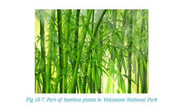
3. Mukura forest
The forest was originally about 30 km². However, it has been declining until it is almost non-existent.
4. Bugesera woodlands
The woodlands have been cleared for settlement and agriculture. The local community also collect firewood from the forest. The demand for charcoal in Kigali and other nearby towns has led to large scale charcoal production in Bugesera woodlands. This has reduced the woodlands drastically.
END OF UNIT REVISION EXERCISE
1. Draw a map of Rwanda and locate the forest areas.
2. Explain the importance of forests in Rwanda.
3. Identify the causes of deforestation and discuss the solutions being undertaken in Rwanda.
4. Explain why some areas in Rwanda are under more risk of deforestation than others.
5. Explain the effects of forestry on the sustainable development in Rwanda.
Unit 17: FISHING AND FISH FARMING IN RWANDA
Key unit competence
At the end of this unit, you should be able to investigate the impact of fishing and fish farming activities on sustainable development of Rwanda.Fishing is one of the oldest economic activities carried out by communities that lived near water bodies. Fishing is the process of extracting valuable resources that are found in water bodies. Some communities carry out fishing as their main source of income while for others it is a part time activity. For some, it is a sporting activity while for others, it is undertaken because fish provides an alternative source of protein.
Activity 17.1
Read the following story then answer the questions that follow:
Mukambanguza lives near Lake Kivu with her parents. She is fourteen years old.
Her father is a fisherman. He has been fishing in Kivu since Mukambanguza was 2 years old. Before then, he was a motor rider. He quit driving a moto because he said it did not give him enough money to feed the family.
Since he became a fisherman, he has built a good house for his family. He recently bought a piece of land in addition to what he already had.
“I love to fish,” he told Mukambanguza the other day.
“Why dad?,” she asked.
“It is because fishing has built our house. It has also clothed us for a long time now.
“Fishing has also given you the education you enjoy now.”
“Dad,” she started with an inquisitive voice, “our teacher said it builds our bodies!” She sounded confused.
“It is true my daughter,” he replied. “However, I will explain what I meant by the statements I made earlier on. When you get back to school, ask your teacher what she meant by that,” he replied, while pulling a chair to sit.
From the story above, it is true that fishing has many benefits.
1. List the benefits Mukambanguza’s family have got from fishing.
2. Explain what Mukambanguza’s teacher might have meant.
3. In your opinion, was it right for Mukambanguza’s father to quit riding a moto to fishing? Explain your answer.
17.1 Major fishing and fish farming areas in Rwanda
Since Rwanda is a landlocked country, there is no marine fishing. However, there are many fresh water lakes, rivers and wetlands that have large stocks of fish. From them, fishermen are able to carry out both commercial and subsistence fishing.
Fish farming is also widespread in wetland areas. They have achieved this by constructing fish ponds because water is readily available. It is carried out mainly in lowland valleys which were originally swampy. Some ponds are constructed along river valleys where it is easy to obtain water for the ponds.
Activity 17.2
1.Copy the map of Rwanda provided below and label all the rivers and lakes shown.
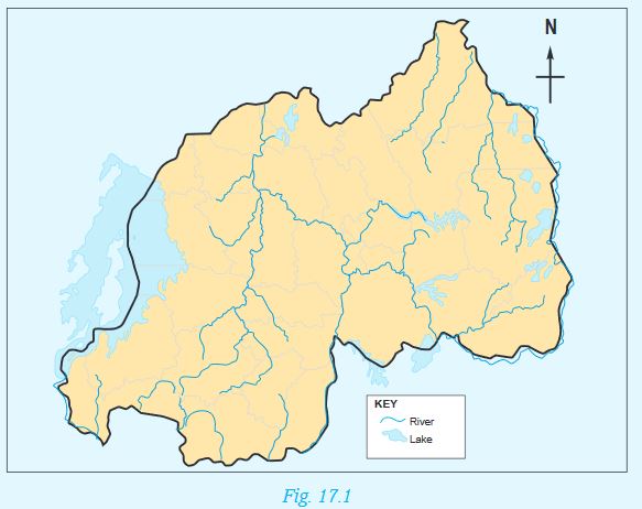
2. In groups of five, research about:
i) fish farming areas in Rwanda.
ii) The major fish farming areas in Rwanda.
3. Indicate on the map you have drawn the major fish farming areas in Rwanda.
4. Carry out a research from geographical documents and the Internet to find out:
(i) The water bodies where commercial fishing is carried out.
(ii) The main species of fish caught in each of the water bodies.
5. Find out the most common species of fish that are reared in the fish farms and why.
Fishing and fish farming in Rwanda are carried out in the following fisheries:
1. Lakes
Rwanda has over twenty lakes. All these have sufficient stocks of fish. The largest of them is Lake Kivu which is also the main commercial fishery. The lake has many inlets that provide ideal breeding grounds for fish. Apart from Lake Kivu, other large lakes are Muhazi, Mugesera, Rweru, Cyohoha, Burera and Ruhondo. On the eastern part of the country, there are many shallow lakes that are also important fishing areas for the local communities.
2. Rivers
Rwanda has many rivers where fishing is carried out. Examples of these rivers are Akagera, Nyabarongo, Akanyaru, Muvumba, Rusizi, Mukungwa and Kagitumba. Fishing in the rivers is mainly carried out by local communities using traditional methods. Here, fishing is for subsistence use. However, the surplus is sold in local markets.
3. Wetlands and ponds
Rwanda has many wetlands especially in the eastern part of the country. Naturally the swamps have some species of fish that breed in such environments. Some of parts of the wetlands have been modified to become ponds for fish farming. Many of these ponds are individually owned.
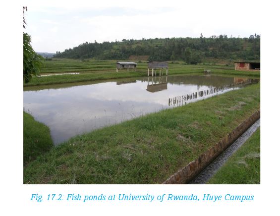
17.2 Factors influencing fish farming in Rwanda
Activity 17.3
In groups of five, identify the factors influencing fishing and fish farming in Rwanda. Write down the findings, and make relevant conclusions.
(i) Existence of natural wetlands: Rwanda has many areas of lowlands and valleys where water is readily available to make fish ponds. The areas are either natural swamps or low lying areas near permanent rivers or shores of lakes.
(ii) Government encouragement: The government has favourable policies to support fish farming in order to expand the fishing industry. For instance, to promote fish farming in the country, the government has initiated theInland Lakes Integrated Development and Management Support Project (PAIGELAC) which gives farmers a lot of financial and skill development support.
(iii) Availability of capital: many fish farmers have formed cooperatives which makes it easy for them to obtain loans for capital to construct and stock fish ponds.
(iv) Availability of trained extension workers: Fish farmers get advice from trained extension workers who make frequent visits to the farms.
(v) Availability for local market: As more fish farms are established in different part of Rwanda, the culture of fishing and eating fish is introduced to more people. Many fish farmers are able to sell their fish to individuals, the nearby towns and to hotels and restaurants.
(vi) Availability of labour: Individual family members or members of cooperatives provide the necessary labour for activities such as construction of ponds, pulling of weeds from the ponds and fish harvesting.
(vii) Expansion of fishing area: There has been widespread introduction of fish farming in the wetlands and along the shores of some lakes where fish ponds are easy to construct.
17.3 Methods of fishing used in Rwanda (traditional and modern)
The methods used to catch fish in different fisheries depend on the type of fishery. In shallow waters, simple traditional methods are applied while in deep waters, more sophisticated methods are used.
Fish found in the fisheries in Rwanda are not commonly caught for commercial use but by the local communities for subsistance purposes.
Activity 17.4
Study the photograph below and answer the following questions.
1. Name a lake in Rwanda where this photograph may have been taken.
2. Describe the fishing method being used to catch fish in the lake.
3. Explain why the method being used is suitable.
4. What are the possible problems that the fishermen are likely to face?
5. Explain how the problems stated in 4 above can be solved.
Most of the people in Rwanda who engage in small scale fishing use traditional methods of catching fish. These include:
a) Poisoning method
b) Spearing method
c) Trapping
d) Hook method
e) Basket method
f) Gill method
g) Line fishing method
a) Poisoning method
This involves putting poison in water so that the fish dies. People then collect the dead fish. The disadvantage of using this method is that the poison may kill all the fish even the young ones.
b) Spearing method
This method is used in shallow water where a spear is aimed at a fish and then it is released to strike the fish. The disadvantage is that one may end up missing the target or only catch one fish after spending long hours trying to spear the fish.
c) Trapping
This involves laying a trap on the path where fish passes. The trap is left in position for several hours before one checks if any fish has been caught. It is used in shallow water especially in rivers.
d) Hook method
A string attached to a strong stick is tied to a hook on its other end. A bait is stuck to the hook and the string thrown into the water. The fisherman holds the stick and waits to notice the string being pulled as fish is caught and tries to free itself. The sticks with the strings can be firmly fixed on canoes.
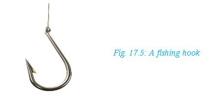
e) Basket method
This involves laying baskets made of reeds in the water. The basket has a wide mouth for getting in and a narrow mouth for getting out. Once the fish enters, it is not able to free itself since it cannot find its way out.Commercial fishing methods are used by people who engage in large scale fishing in lakes like Kivu and Ihema. They use two main methods.
f) Gill net method
Large nets are attached to a boat. The boat then drags the net in the water and fish get caught by the gills on the mesh of the net. The net is pulled into the boat to empty the catch and thrown back in the water for another round. Large numbers of fish are caught per throw.
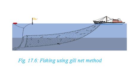
g) Line fishing method
This involves using a long strong line with many hooks on which baits are attached. The line is attached to a boat that drags it along in the water. Fish are caught as they try to eat the baits. The line is pulled back into the boat to remove the catch. This is repeated to catch the required load of fish.
17.4 Problems faced by fishing and fish farming in Rwanda and possible solutions
Rwanda’s fishing industry has been facing a number of problems that must be addressed for the industry to grow. The following are some of the problems and the way they are being solved.
Activity 17.5
In groups, carry out a field study of a nearby fish farm or fishery. Your report should include the following information:
1. Name of farm or area studied.
2. Ownership of the fishery.
3. Problems affecting fishing in the area.
4. How the problems are being addressed.
Present your report in class for discussion.
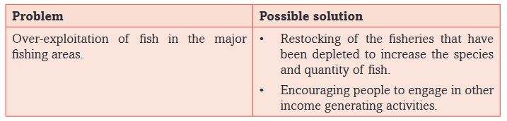
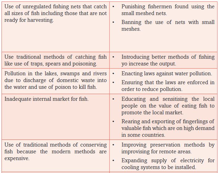
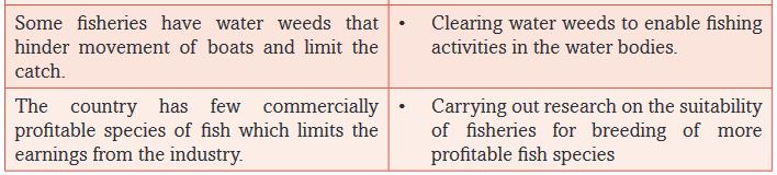
17.5 Fish preservation and conservation in Rwanda
Fish preservation
Preservation means to keep something in good condition. Fish preservation means keeping fish in a state where it is suitable for human consumption. Fish is highly perishable. Its condition begins to deteriorate as soon as it is caught and removed from water.
Modern methods of preserving fish are expensive. Many fishing communities in Rwanda use the traditional methods since they cannot afford the modern ones. Also their catch of fish is not so much as to warrant them to invest in modern methods of preservation.
Activity 17.6
In groups, use geographical documents and internet to carry out a research on the fish conservation and preservation methods used in Rwanda.
Write a report on your the findings for class discussion.
17.5.1 Traditional methods of preserving fish
The traditional methods of preserving fish are still very common today. They include:
a) Sun drying
b) Salting
c) Smoking over open fire
These methods are also described as fish curing. Smoking and sun drying evaporates the moisture in the fish that may encourage bacteria that leads to rotting.
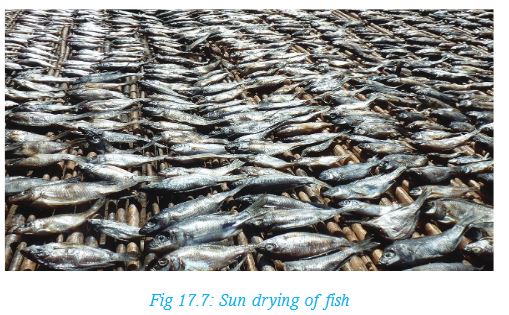
Fish salting means applying salt on the fish. As much salt as possible is rubbed on the fish to kill the bacteria that causes rotting. Fish that is preserved using the traditional methods cannot last for too long because if moisture settles on it, it will begin to rot.
17.5.2 Modern methods of preserving fish
Modern methods of fish preservation are:
(i) Fish canning
(ii) Freezing
Canning involves processing and packing fish in pressurised cans that are tightly sealed. Canned fish can last for a long time.
Fish freezing means keeping fish in very cold chambers which makes the fish to freeze. Bacteria cannot survive on frozen fish, and thus such fish can stay for a long time.
Fish conservation
Conservation of fish means to protect fisheries so that they are not overexploited. It also involves ensuring that the water remains in good quality for continued breeding of fish. If this is done, then fishing will be sustained.
Conservation processes include:
(i) Using the correct size of nets so as to avoid catching young fish that is not ready for harvesting. Only the mature fish should be caught.
(ii) Establishing fish hatcheries to breed young fish for restocking the depleted fisheries. Currently the Kigembe hatcheries is supplying fingerlings to many fish farmers.
(iii) Avoiding poisoning of fish and any other practices that lead to water pollution so that fish live in healthy environment.
(iv) Establishing fish farms to subsidise the natural fisheries.
(v) Restocking and introducing new fish species such as Tilapia niloticus so as to increase fish varieties in the fisheries.
(vi) Educating and capacity building so that people are aware of the importance of practising sustainable fishing methods. This can be done through extension workers or by organising study tours to successful fish farms in order for farmers to acquire more knowledge and skills on sustainable fish farming.
(vii) Protecting the watersheds to ensure sustained supply of water to the lakes and rivers.
END OF UNIT REVISION EXERCISE
1. Identify the major fish species caught and major fishing areas of Rwanda.
2. Explain the factors responsible for the growth of fishing industry in Rwanda.
3. Which fishing methods are commonly used in Rwanda and why?
4. Explain the problems facing the fishing industry in Rwanda.
5. Describe the fish preservation and conservation methods used in Rwanda.
Unit 18: MINING AND QUARRYING IN RWANDA
Key unit competence
At the end of this unit, you should be able to investigate the impact of mining and quarrying activities on sustainable development of Rwanda.Introduction
The mineral industries consist of mining and quarries.
A mineral is a naturally occurring solid substance found in rocks of the earth. Minerals are part of natural resources in Rwanda. They are found in many parts of Rwanda especially areas of volcanic rocks.
Minerals differ in appearance and chemical composition. They make the second largest export commodity in the Rwandan economy.
• Precious minerals such as Gold
• Mineral fuel such as Methane Gas and Peat deposits
• Gemstones including Beryl,Wolfram, Tin, Limestone and Colombite
More minerals are yet to be exploited since extensive explorations are still underway.
Activity 18.1
Using an atlas, make a list of all the minerals found in Rwanda. This should be done in pairs.
To learn more about mining and minerals in Rwanda, we shall cover the following areas:
• Definitions (mining and quarrying)• Minerals and mining areas in Rwanda
• Quarrying: sand, clay, rocks and limestone
• Methods of mining in Rwanda
• Factors influencing mineral exploitation in Rwanda
• Importance of mining and quarrying in Rwanda
• Problems hindering mining and quarrying in Rwanda
• Examples of areas affected by over exploitation of mineral resources
• Effects of mining on the natural environment in Rwanda
• Future prospects of mining in Rwanda
• Solutions to the problems affecting mining in Rwanda
18.1 Meaning of mining and quarrying
Rwanda has a variety of minerals based on the type and distribution of ore bearing rocks. Rwanda’s mineral industry includes mining and quarrying. Minerals may be found at or near the surface. Others lie at great depths in the earth’s surface.
The place where minerals are dug out or drilled is referred to as a mine. The process of obtaining the mineral is referred to as mining.
The excavation of building stones, gravel, sand and clay from the ground is called quarrying. It also involves the production of building materials and extraction and processing of semi-precious stones.
18.2 Minerals and mining areas in Rwanda
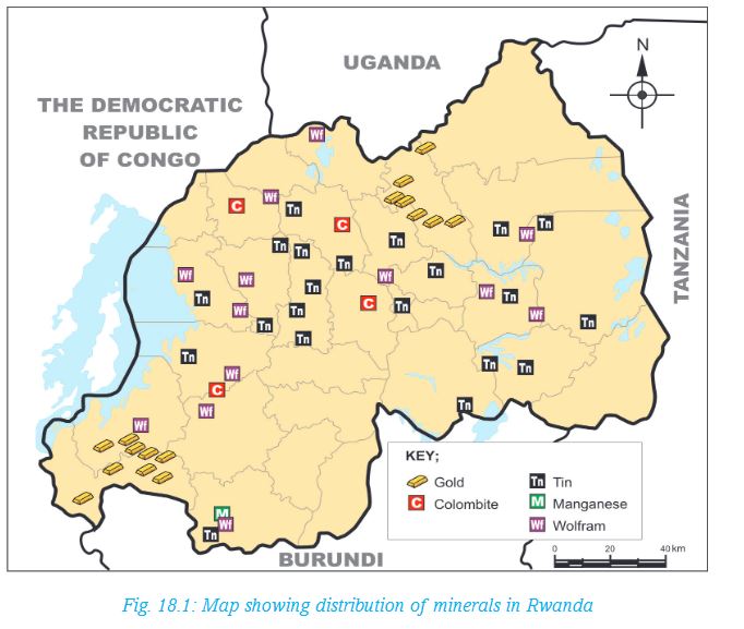
Activity 18.2
1. In groups, using a map showing the distribution of minerals in Rwanda, find out the major minerals and mining areas.
2. Find out areas where sand, clay, rocks and limestone are obtained from.Write down the findings in your note books.
3. Trace the map showing the minerals. Indicate all the minerals shown. Identify the provinces where each mineral shown is found.
Present your finding in class.
The distribution of minerals depends on the kind of rocks found in a given area.Rwanda has different kinds of rocks. Therefore, mineral deposits are widely spread.
18.3 Methods of mining in Rwanda
Activity 18.3
In pairs, use geographical documents, Internet and photographs of mines to observe and describe the methods of mining used in Rwanda.
Minerals found in the rocks are dug out from the earth in many ways. The method of mining chosen depends on the type of mineral and its occurrence. That is, whether in solid, liquid or gaseous state. It also depends on where the mineral ore is found, that is, near or at the surface or deep in the earth’s crust.
Other factors include the easiness of mining the mineral and how much the process will cost.
The following are some ways of mining the minerals:
Open-cast mining
In this method, the mineral ore lying near the surface is blasted to loosen the ore. Thereafter, the waste rocks are removed by use of power shovels. The mineral is then removed in successive layers.
Activity 18.4
The picture below shows the mining of limestone.
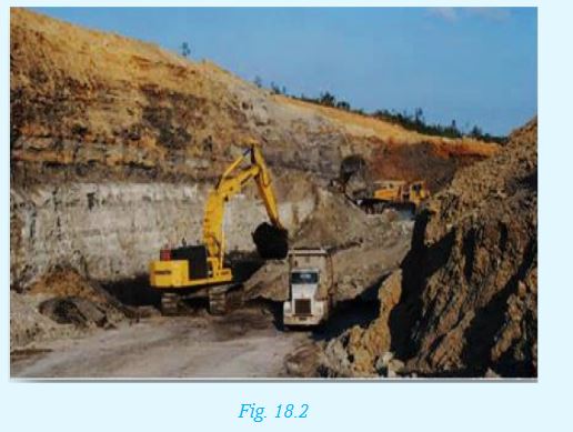
1. Identify two things you can see in the picture.
2. Suggest two benefits of such type of mining.
3.Write two negative effects the mining is likely to have on the environment
Placer mining method
Placer mining is a method used to extract minerals found in alluvial deposits such as tin, tungsten and gold. Placer mining takes place in two forms:
a) Panning
b) Dredging
a) Panning involves putting the sand or gravel dug from the river bed on a circular shallow pan. The pan is tilted and swirled round in such a way that lighter materials are washed leaving heavier mineral particles at the bottom of the pan. The minerals are then hand-picked.
b) Dredging is mostly used in mining tin and gold. In this method, a dredger floats on the river or lake bed. It is used to dig up and scoop the alluvium containing the mineral. The alluvium mixed with water is put in large containers. The containers are tilted slowly. The lighter materials are washed off leaving the heavier materials containing the minerals which are then sorted out.
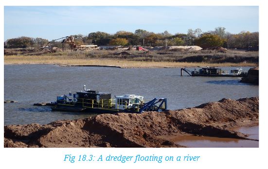
Drilling method
There are minerals that are found in rivers and lake beds as weathered products. This method is often used to bring up such under water mineral deposits efficiently and cheaply for example, the mining of Methane on Lake Kivu.

Underground mining
This method is used where minerals are found deep in the earth’s crust. In this method, the overburden is first removed by blasting the overlying rocks. Vertical shafts are sunk. From the shaft, horizontal tunnels are dug to reach the mineral which is later lifted on to the surface. The roof of the mine is supported by using pit props, steel or concrete beams to prevent collapse of mines. The mines are also ventilated to allow free flow of air. This method is used in the mining of Potash Salt and Tungsten.

Activity 18.5
The following photograph shows a man working in an underground mine.
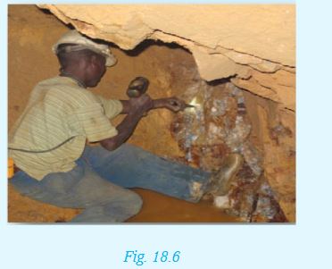
1. What protective gear should the miner have and why?
2. Suggest possible dangers the man could experience.
3. Write two negative effects the mining is likely to have on the environment.
At times underground mining is dangerous because of poisonous gas leakage, collapse of mines and flooding, general mechanical errors from malfunctioning mining equipment and use of improper explosives are some of the common causes of accidents.
18.4 Factors influencing mineral exploitation in Rwanda
Minerals occur in varying amounts. However, some minerals are mined while others are not. The mining of any mineral is influenced by the following factors:
Activity 18.6
In groups, discuss and make notes on how the following factors influence exploitation of a mineral:
• Government policies
• Grade of the ore
• Value of the mineral
• The size of the deposit
• Mining method used
• Mining Costs
• Transport costs
• Labour
Government plans
Every government plans for the minerals to be mined. This is after considering several factors such as: the size of mineral deposits; cost of mining and value of the mineral in the market. Investigations are also carried out to establish if there will be any harmful effects to the environment and the surrounding communities.
Grade of the ore
The grade of the ore is the percentage of the valuable mineral against the waste rock. High grade ores are of higher economic value. If the mineral ore is low grade, it often remains unexploited.
Value of the mineral
The value of the mineral in the market determines whether the mineral will be exploited or not. For instance, Rwanda undertakes mining of minerals such as Casseterite, Wolfram and Gold which fetch high amounts of money that cover the cost of mining and other related expenses. Similarly, minerals that are low valued but are found in large deposits are mined as the cost of mining is easily covered.
The size of the deposit
The mineral deposits in Rwanda are of different sizes. Large deposits are likely to last for long, while small size deposits may be exploited for just a short period of time.
Mining method used
The occurrence of the minerals whether on or under the surface influences the choice of method to use in extracting. Opencast methods of mining are cheaper than the underground methods of mining.
Mining costs
Mining requires a huge capital spending. This includes the cost of opening up the mine, mining process, transport and reclamation of the mining area. The Government of Rwanda encourages international private firms to engage in mining since they are more financially established. The Government also helps small scale miners to get funds through Cooperatives to enable them participate effectively in the industry.
Transport costs
Mineral ores are bulky and therefore transport costs are normally high. Transport costs depend on the distance of the mining site to the factory and the market.
Labour
The mining industry requires high level mechanisation. It requires people who are skilled. For a long time the mining industry in Rwanda has slowed down because of inadequate qualified personnel. The picture below shows workers in a mine.
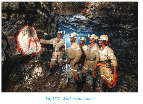
Activity 18.7
In pairs:
1.Discuss two observations you can make from the photograph in figure 18.8.
2.Copy the diagram below in your note book. Complete the diagram with the personnel required.The first two are done for you. You are free to add more shapes.
Share your findings with your class
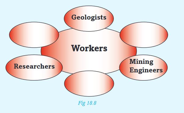
Did you know?
The mineral materials make up nearly all the planet that we live in.18.5 Importance of mining and quarrying in Rwanda
i. Soil, plants, and animals gets mineral for growth such as potash and nitrates.
ii. Many people are directly employed in the mining industry. Others are employed indirectly such as in Banking, insurance, repair works and information services and marketing. The income helps them obtain food and shelter. It also provides opportunities to get services such as education and health.
iii. The minerals mined are traded with other countries and the government gets foreign exchange. The money is used to develop other sectors of the economy such as agriculture.
iv. The minerals provide industrial raw material for instance:
- Gold, Diamond and Silver are used in jewellery making.
- Sand is used in making glass.
- clay for bricks, tiles and pottery.
- Salt is used as a food preservative for fish and meat. Salt has medicinal values too.
- Limestone is used in cement making and for improving the soil.
Activity 18.8
Write a brief essay for class presentation with the heading:
The importance of mining to my community
18.6 Problems hindering mining and quarrying in Rwanda
There are several problems that hold back the exploitation of minerals in Rwanda. The problems include:
i. Some minerals are found in small deposits or the grade of the ore is low such that it is not economical to mine.
ii. The country lacks sufficient funds to explore and carry out mining.
iii. Some valuable minerals are found in remote areas which are not easily accessible.
iv. There is shortage of qualified personnel to work in the mining industry.
v. The minerals may be found near built-up areas which if mined may be harmful to the health of the people.
vi. Some corrupt people smuggle minerals out of Rwanda.
Areas affected by over exploitation of mineral resources
Activity 18.9
Using geographical sources, prepare a list of areas affected by mining in Rwanda.
Present your findings to the class.
Open pits after mining may cause health hazards. This may be from the pools of water that form in the pits which are not only breeding grounds for mosquitoes. Accidents are also likely to occur where such pits exist. Mining companies often fail to restore the affected areas because there is no direct benefit from such an activity.
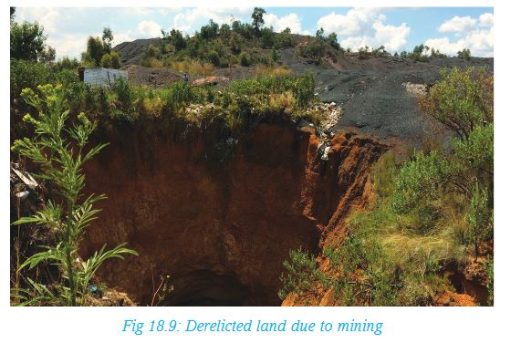
18.7 Effects of mining on the natural environment in Rwanda
The environment is supposed to serve people for a long time. This can only happen if it is carefully used. Mining and other related activities such as transport may affect the environment negatively. This is known as environmental degradation where by the productivity and the general beauty of the land deteriorate. However, the Government is enforcing laws to make mining companies to abide fully with the set standards of a clean environment and also restore the damaged land. This is the way we can use our environment sustainably.
In spite of this, mining has had the following effects on the environment in Rwanda:
(a) Destruction of vegetation
(b) Land dereliction
(c) Pollution
(a) Destruction of vegetation
In areas where mining sites have been set up, the vegetation is cleared. This destruction of the vegetation leads to exposure of soil to erosion and in some cases results to landslides.
(b) Land dereliction
Open pits left behind after open cast mining causes permanent damage to the land where the natural beauty of the landscape is lost. This is called land dereliction.
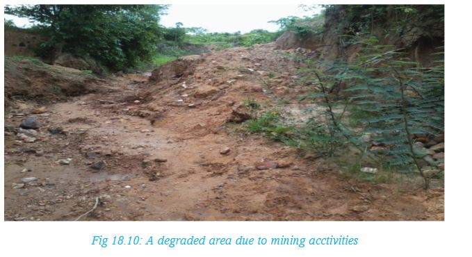
(c) Pollution
Mining activities pollute the environment during the removal and processing of minerals. Smoke and dust particles are released into the air while poisonous industrial wastes are discharged. Some poisonous substances from mining also seep into water sources such as lakes, rivers or wetlands. All these poisonous substances cause air, water, land and noise pollution which are harmful to human health. The pollution may cause respiratory and skin diseases.
Did you know?
In October 2012, Rwanda’s Ministry of Natural Resources suspended mining activities in the country’s Western Province on the basis that they were endangering the nearby River Sebeya. This left over ten companies that were involved in Wolfram and Coltan redundant.
Activity 18.10
Study the following problems that affect mining together with others you may know.
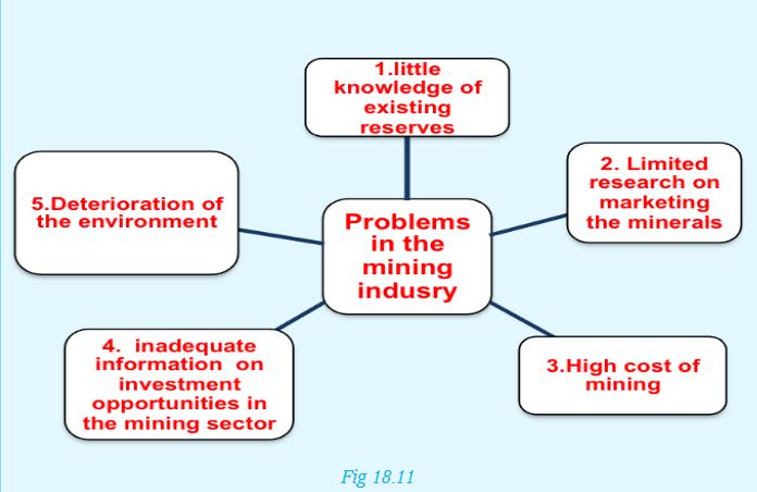
1. In groups, study the problems of mining identified.
2. Describe and record the possible solutions for each problem.
3. Prepare a class presentation on possible solutions for each problem.The first two have been done for you.Mapping and exploring new mineral deposits to expand the existing reserves.
Limited research on marketing the minerals
- Carrying more exploration on individuals, Companies and agents interested in mining.
- Adding value to the minerals in order to fetch high prices in the market.
- Looking for more trading partners.
18.8 Future prospects of mining in Rwanda
The future of mining is generally bright with:
i) The government exploring for more minerals to reduce dependence on few minerals.
ii) Minerals are non-renewable; as such the government has to ensure that wasteful and careless mining methods are reduced. Mine sites with efficient water and wastes management system will be increased.
iii) The government plans to involve more people in the mining industry particularly women and youth.
iv) The government has put in measures to train more Rwandans in various fields such as mining technologies, Geology, Artisan and Entrepreneurship in collaboration with Private Companies and developed countries.
v) The government is expanding transport and communication networks to improve the mining industry. The government has formulated ways of tracing the amount of minerals mined to their destination to stop corruption and exploitation of Rwandan resources by individuals and foreign firms.
END OF UNIT REVISION EXERCISE
1. Name three precious minerals mined in Rwanda.
2. Complete the table below with the correct answers.
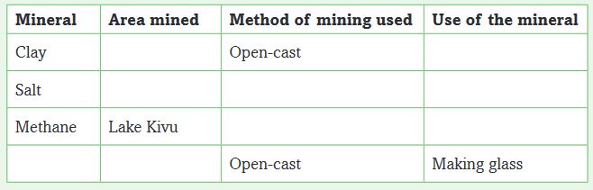
3. Correct this statement: We need not worry too much about our supply of minerals because other materials can serve all purposes the metals can serve.
4. From your study of minerals write two key things you have learnt you would like to share with your community.
Unit 19: POWER AND ENERGY IN RWANDA
Key unit competence
At the end of this unit, you should be able to investigate the impact of power and energy production on sustainable development of Rwanda.Introduction
Energy is the power required to do work. It is derived from wind, water, petroleum, coal and natural gas among other sources, mainly to provide light and heat or to drive machines.
The Government of Rwanda recognises that availability of efficient and reliable energy supply is a requirement for social, economic and political growth. For this reason, it works closely with development partners and private organisations to help in the generation, transmission and distribution of energy.
In this unit you will cover:
• Renewable and non-renewable energy resources
• Importance of power and energy resources in Rwanda
• Problems and future prospects for power and energy production in Rwanda
• Efficient utilisation of power and energy resources in Rwanda
19.1 Renewable and nonrenewable energy resources
There are two main groups of energy sources. These are:
(a) The renewable sources of energy
(b) The non-renewable sources of energy
Energy resources that can be used without reducing the quantity available for the future for example, sun, wind, wood, biomass, water and geothermal steam and draught animals are referred to as renewable sources of energy.
The energy sources that are exhaustible if not well managed or extracted are non-renewable sources of energy. The examples of non-renewable sources of energy include petroleum, coal, natural gas and uranium.
Activity 19.1
Use text books, Internet and other geographical resources to find out the major forms of power and energy.
1.In pairs, discuss sources of energy.
2.Classify the following sources of energy as either renewable or non renewable:Coal, electricity, wood, solar, wind, water, biomass, waves and tides, oil, natural gas, peat.
Present your findings in form of a table as shown below:

3.Which of the sources listed above are available in Rwanda?
19.2 Energy resources in Rwanda
The sources of energy in Rwanda include:
1. Hydroelectric power
2. Gas
3. Biomass
4. Peat-based energy
5. Geothermal power
6. Biogas
7. Solar power
8. Wood fuel
Each of these has been explained below:
1.Hydroelectric power
Fast moving water produces power used in the generation of electricity. Rwanda has small and medium-size hydropower stations at Ntaruka, Mukungwa, Gihira in Rabavu District, Gisenyi, Rukarara and Nyabarongo.
On the other hand there are regional hydroelectric power stations whichare resources that Rwanda shares with neighbouring countries such as Rusizi on the border with Democratic Republic of Congo and Rusumo Falls on the border with Tanzania. The first two phases of Rusizi have been developed.
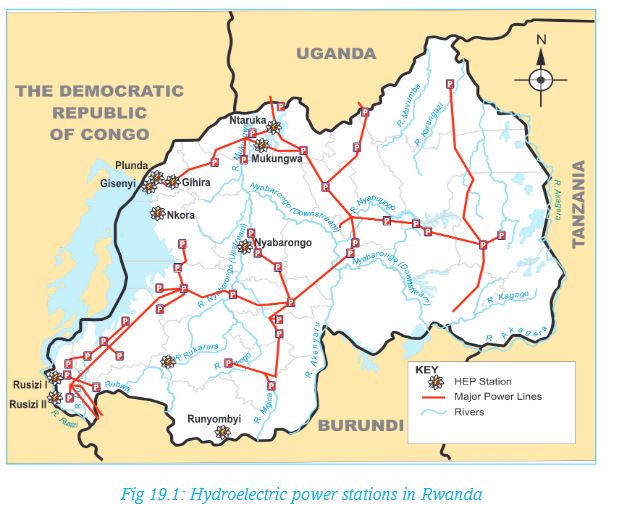
2.Gas (Methane)
Rwanda has an important naturally occurring methane gas in Lake Kivu. The usable Methane gas found at the bottom of the Lake at a depth of 250 meters is estimated to last for many years. The gas is extracted to produce electricity. The photograph below shows the extraction platform that floats on Lake Kivu.
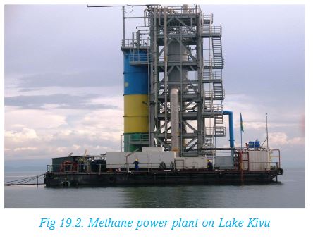
3.Biomass
Biomass is a term used to describe living vegetable matter such as trees and shrubs from which energy can be obtained. Biomass is also generated from agricultural wastes, cereals and forage, crop residues, water weeds, human and animal wastes. These resources can be used as fuel and also to generate energy.
They have the following advantages:
• They are widely available and naturally distributed.
• They generally require low cost inputs.
• They occur in abundant supply.
• They can be domestically produced for energy.
• They have low carbon, and are cleaner than fossil fuels.
• Waste can be converted into energy, helping further in waste management.
4. Peat–based energy
This is a brown, soil-like material, partly decomposed vegetable matter found mainly in the wetlands that are salty. The peat takes very many years to form. Peat is soft and easily compressed. Under pressure, water in the peat is forced out. Upon drying, peat can be used as alternative source of energy.Peat, when harvested, looks like dark, earthen brick. Rwanda has sizeable peat reserves in Gishoma (Western region) and Akanyaru (Southern Province). There are also some smaller reserves near Kigali.
5. Geothermal power
Geothermal power is generated from natural heat in volcanically active areas. Temperatures in the interior of the earth are very high. When the heated rocks come into contact with ground water, steam is released. It is tapped to generate geothermal power. It is a reliable source of energy that supplements hydropower generation. The main fields are Karisimbi, Rubavu, Kinigi and Bugarama.
6. Biogas
Biogas is a mixture of methane and carbon dioxide from the fermentation of food, agriculture and animal waste that can be turned into electricity and heat. Rwanda has installed biogas plants in its prisons.
7. Solar Power
This power is generated from the sun. It is tapped using solar electric devices which are of different sizes. The devices convert solar power into electricity used in cooking, drying grains, heating water among other uses. There are two solar power stations in Ngoma and Rwamagana Districts.
Did you know?
Wind is one of the oldest sources of power used by man. Our ancient ancestors used the wind to propel boats, grind grain and pump water.8. Wood Fuel
This refers mainly to firewood and charcoal. It is a renewable source of energy. This is the most common source of energy for cooking and heating. Use of wood fuel has put a lot of pressure to the existing forest resources.
Activity 19.2
Class project
With the help of your teacher, carry out the following class project:
1.Consult the older members of your community and collect evidence to show how people used energy in the past. The evidence could be oral, written or visual.
2.Gather evidence on how people use energy today.3.Write a report giving the probable reasons for the similarities and differences.
4.Discuss the report in class
19.3 Importance of power in the development of Rwanda
Activity 19.3
Use documents, Internet and maps of Rwanda, photographs or local environment to identify the importance of energy in:
i.Domestic lighting
ii.Public lighting
iii.Industrial power
iv.Commercial
Write down the findings for class discussion.
Efficient and reliable energy supply is necessary for economic development of Rwanda. This is because it is a critical input in industries that produce goods and services.
Energy is required for diverse applications including heating and cooling, lighting, moving machines among others. However, it should be noted that no single energy source will meet Rwanda’s energy needs in isolation.
The following are some of the reasons why power development is important in the development of Rwanda:
i. The Energy sector creates direct job opportunities for those in construction of the dams, production and supply of the energy. Indirectly, there are those employed in energy related industries that supply equipment, provide repair works transport and communication among other opportunities, this raises people’s standard of living.
ii. Power is a source of revenue to the government of Rwanda through taxes generated from those employed directly or indirectly. The Government also gains through energy pricing and direct investments in industries.
iii. Development in the energy leads to the growth of urban centres as well as trade and commerce.
iv.Production of power in Rwanda reduces the dependence on imported fuel such as petroleum.
19.4 Problems of power and energy production in Rwanda
(i) Insufficient capital
Production of power requires heavy capital outlay. Rwanda has limited capital to invest in power generation.
Activity 19.4
The pie chart below shows the energy balance in Rwanda. Stud it carefully then answer the questions that follow.
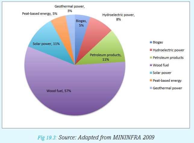
a) From the pie chart, which is the leading source of energy?
b )Make three other conclusions from the graph.
c) Explain some of the challenges that faces the leading source of energy in Rwanda.
(ii) Shortage of skills
Rwanda has few engineers for the energy sector.
(iii) High cost of power
Many Rwandans cannot afford to buy power which limits power production.
(iv) Weather changes
Changes in climatic conditions cause flooding or reduction in water supply during dry seasons. This affects hydroelectric power production.
19.5 Future prospects for power and energy in Rwanda
Activity 19.5
In groups, explain the measures that the government of Rwanda has taken to ensure increased energy production. Base your explanation on the research you will have carried out from the Internet and other geographical sources.
The Government of Rwanda has put in place plans for improving the future of power and energy. The measures taken include:
i. Increasing access to electricity by households with particular emphasis on remote and rural areas.
ii. Intensifying regional cooperation in Eastern Africa to expand the shared hydropower projects.
iii. Working with Banks and Private agencies to supplement funds for diversifying energy sources.
iv. Strengthening education and training to gradually get more skilled personnel required in the energy sector.
v. Lowering the energy pricing to levels that are affordable by most people.
vi. Giving subsidies to those wishing to produce energy.
vii. Diversifying sources of alternative energy such as wind, methane gas and solar so that most people can afford and reduce the reliance on wood fuel.
viii. Expanding and setting up isolated micro-hydro power stations to remote rural areas.
19.6 Efficient utilisation of power and energy resources in Rwanda
Activity 19.6
Saving energy is a sign of responsibility. List ways in which you save energy at home and at school.
There are very many ways in which we can save energy as discussed above.
Activity 19.7
In groups, think about “Green Energy Use.”
Explain ways of helping the community to use green energy.
Present your findings for class discussion.
Below are ways that we can use to ensure effective utilization of energy:
i. Introduction of motivations such cash power.
ii. Development of alternative energy sources such as solar, geothermal, wind, methane gas, biomass to supplement the available non-renewable power sources.
iii. Use of efficient energy saving stoves or cookers to limit the use of fuel wood for industrial and domestic purposes. Appropriate technology is applied in the construction of the cookers so that they are non-polluting cheap and simple to use.
iv. Promotion of effective energy programmes such as low power consumption bulbs.
v. Switching off lights when not in use.
vi. Encouraging the use of well-maintained vehicles with low fuel consumption.
vii. Educating people on energy making, conservation and management.
END OF UNIT REVISION EXERCISE
1. a) Explain how water is a renewable source of energy.
b) Give three examples of non-renewable energy sources.
2. Suggest four reasons why most people in Rwanda mainly use wood fuel.
3. In which ways could the communities use wood fuel effectively?
4. Describe the problems that Rwanda experiences in the production of Hydro-electric power.
Unit 20: INDUSTRY IN RWANDA
Key unit competence
At the end of this unit, you should be able to investigate the impact of industrial growth on sustainable development.Introduction
An industry is an economic activity that leads to the production of goods or services. There are three types of economic activities also referred to as industries. These are:
• Primary activities
• Secondary activities
• Tertiary activities
We refer to agriculture,mining,fishing and forestry as primary industries. This is because they involve extracting raw materials at the initial or primary stage.
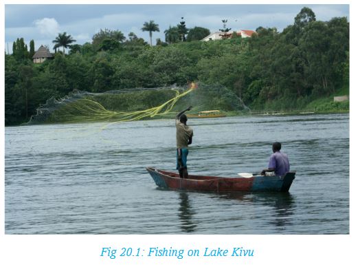
In order to add value to these raw materials, they are processed in a factory. For example, maize is a primary raw material but maize flower is processed maize whose value is higher than that of maize. Processing and manufacturing are referred to as secondary industry.
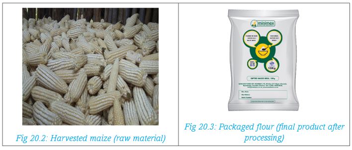
The third type of industries are the tertiary or service industries. These are the activities that make it easy for the primary and secondary industries to be carried out. Examples of tertiary industries are transport and communication, trade, insurance and banking services.

Activity 20.1
Carry out this activity in pairs:
For each type of industries described above,provide five examples.
In this unit, we shall study the impact of growth of secondary industries in sustainable development.
20.1 Classification of industries
Some industries are large scale while others are small scale.
Large scale industries are those that require large amounts of capital to set up. They also may employ a large labour force. They use large amounts of electricity. Their final products are in large quantities.
Large scale industries are owned by large companies or by the government. Examples of large scale industries in Rwanda are those involved in beer brewing, making of soft drinks, cigarette manufacturing and cement manufacturing.
Activity 20.2
In groups, use geographical documents, the Internet, photographs and local environment to categorise industries in Rwanda. Prepare a list of all the large scale and another list of small scale industries in Rwanda.
Small scale industries are industries whose inputs and outputs are in small quantities.Such industries may be owned by an individual or by a family. Examples of such industries include shoe repairing and tailoring.
a) Agro-based industries
These are industries that use agricultural raw materials. Some are large scale while the others are small scale.They can be classified into two categories.
(i) Food processing industries: These are industries whose products are mainly for human consumption. Examples are Inyange industries, located in Masaka, Kicukiro District. It processes milk and fruit juice in different forms and flavours.It also processes drinking water.Other industries are sugar processing milk processing,tea,coffee processing and flour milling.Many of Rwanda’s industries are agricultural based because the country’s main economic activity is agriculture.
Activity 20.3
In pairs, make a list of crops that must undergo processing before use.
(ii) Agricultural non-food industries: These industries use agricultural raw materials but the products are not for human consumption. They include, manufacturing of animal feeds, leather tanning, shoe making, cotton based textile industries and cigarette manufacturing.
b) Chemical industries
These are industries that use chemical-based raw materials and their products are not for human consumption. They make products such as paints, plastics, fertilisers, synthetics, mattresses and soap. An example is industries in Nyarugenge District which manufactures a wide range of fast moving consumer goods.
c) Mineral-based industries
These are industries that use minerals for raw materials. Examples are mineral crushing and refining,making of roofing materials and cement manufacturing.An example of such industries is Safintra Rwanda which manufactures roofing and steel products. Another example is Cimerwa cement factory.
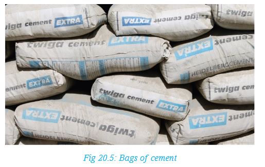
d) Metal work
These are industries in which metals are used as raw materials. In Rwanda, scrap metal is used to make wheelbarrows, cooking stoves, animal feeding troughs, metal gates and metal grills. An example is Steelrwa Industries in Eastern Province, Rwamagana District.
e) Other industries
Furniture and boat making which uses wood as raw materials,fish processing,fishnet making, and handicraft industry.
20.2 Factors for location, growth and development of industries in Rwanda
Before an industry is set up in a place, there are many things that have to be considered. These things determine whether it is appropriate to set up an industry in a given place.
Activity 20.4
In groups of five,carry out a study of a nearby industry.Write your report under the following subheadings:
1.Name of the industry
2.Reasons why the location was suitable for the industry
3.Source of its raw materials
4. Market for the final product
Write down the findings for class discussion
Location refers to the specific site of the industry.
Remember!
In determining the location of a factory, many factors are considered. To avoid environmental degradation, it is usually preferred in an area where waste disposal can be done easily. Such areas are also preferred to be in areas without dense vegetation. This way, the environment is taken care of even as industrialisation continues.
There are different factors that influence location,growth and development of different industries in Rwanda. An industry may start as a small establishment but gradually expands to a large industry.
The factors that favour location, growth and development of an industry include the following:
a) Availability of raw materials
Rwanda has different types of raw materials that attract industries in different locations. There is a wide range of agricultural raw materials such as sugarcane that led to sugar production at Kabuye, milk that is processed at Inyange, tea factory at Mulindi and Rubaya.
b) Availability of capital
The money required to start an industry is called capital. Sometimes, the government, companies and individuals borrow loans to set up an industry. The government is able to get loans from international donors and financial institutions like World Bank to start an industry.
c)Availability of labour
Rwanda has a large population and many of the people get employment in the manufacturing industries.
d) Availability of market
Most of the agricultural and the small scale industries in Rwanda sell their products locally. There are other industrial products which are sold outside the country. For example, the surplus of sugar from Rwanda is sold to the East African countries.
e) Availability of power supply
Industries are located in areas where power is easily accessible. Power is needed to run machines in a factory.Over 60% of the industries in Rwanda are located in Kigali where power is readily available.
f) Government policy
The government of Rwanda has been encouraging investors to set up industries in the country to create employment and to boost economic growth.
g) Availability of water
Some industries such as those making beverages and breweries require plenty of water. The Bralirwa Breweries and Inyange industries use water as a major raw material.
h) Good transport and communications network
It is necessary to have well developed means of transport to be able to move raw materials to the factories and the finished products to the markets.It is also necessary to communicate with the producers of the raw materials and the consumers of the finished goods.
Activity 20.5
Study the photograph below and answer the questions that follow.
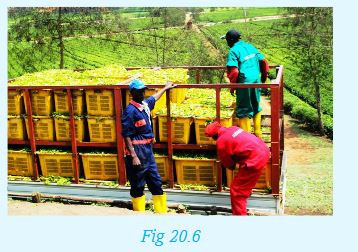
1.Describe the activity taking place in the photograph.
2.Which industry is supplied with the raw material shown?
3.Where in Rwanda is the photograph likely to have been taken?
4. Explain how Rwanda benefits from the marketing of the final product.
20.3 Importance of industries in Rwanda
It is important for any country to do all that is possible to encourage industrial development. The government of Rwanda recognizes the importance of industrial development as a means of promoting economic growth. It is for this reason that favourable policies have been put in place to encourage investors in the sector.
Activity 20.6
Your teacher will organise a visit to Bralirwa Breweries. Alternatively, in groups, use the Internet and any other relevant resources to carry out a research of the Bralirwa Breweries.Find out how the industry benefits:
i) The government
ii) Farmers
iii) Local community
iv) Individual employees
Development of industries have a number of advantages in a country: Some of these have been explained below:
(i) Creation of employment opportunities: Industries create job opportunities enabling many people to get employment and are able to earn income to live on. There are many people in Rwanda who earn their living by working in industries.
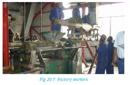
(ii) Generating revenue for government: The government generates revenue by levying taxes to the industries. Also, if the manufactured goods are exported, the country earns foreign exchange.
(iii) Adding value to local products: Processing of raw material increases the value thus earning more compared to selling the products in their raw form. For example, fruit juices sell at a higher price than whole fruits.
(iv) Production of export goods: Some industries produce goods that are exported to enable the country to earn foreign exchange.Rwanda exports sugar to the neighbouring countries to earn foreign currency.
(v) Import substitution: Manufacturing industries supply the local people with goods at lower cost than the cost of similar imported goods. Instead of importing such items as cigarettes, soft drinks, soap and mattress, Rwanda produces the items locally. The country saves foreign exchange which could have been used in importing.
(vi) Development of infrastructure: When an industry is set up at a place, other developments such as water supply, roads and electricity are provided in the area.This benefits the industry as well as the local people.This is true of such industrial complexes as in Bugarama.
(vii) Development of social amenities: Industrial developments attracts development of social amenities such as schools, health centres and recreation facilities. For example, CIMERWA Cement factory has attracted many other developments in the area.
(viii) Controlling rural-urban migration: When industries are set up in rural areas, people get employed there instead of moving to towns in search of jobs. The Kabuye Sugar Factory is in a rural setting and has played some part in controlling rural-urban migration.
(ix) Creating market for raw materials: Development of agricultural oriented industries creates market for farmers. For example, the tea farmers in Rwanda are assured of market for their produce. This promotes agricultural development.
20.4 Problems and effects of industrial development in Rwanda
Industrial sector is very important for economic growth and social development in Rwanda. However the sector is associated with both environmental and social problems. In order to ensure sustainable development, these problems must be addressed through efficient production processes and applying preventive measures to possible problems.
Activity 20.7
Use geographical documents, the Internet, photographs and local environment to research on:
i) The importance and effects of industrial development in Rwanda.
ii) The problems of industrial development.
iii) Possible solutions to the problems of industrial development.
(a) Pollution: Industries can lead to both air and water pollution. Some industries produce chemical substances which if discharged into water bodies are harmful to the living things in the water. Therefore, waste substances from chemical industries must be treated and discharged with care to avoid pollution.
(b) Rural-urban migration: As more industries are set up in towns, more people move from rural areas hoping to get employment in these industries. This causes overcrowding in towns creating pressure and congestion on social amenities like health facilities.
(c) Over-exploitation of natural resources: Resources such as forests are overexploited as the demand for raw materials increase. Forests like Nyungwe are endangered as people exploit timber to supply building and furniture industries.
(d) Displacement of people: Development of industries creates demand for space. As a result, people are made to relocate to allow for building of a factory. This is worse in rural areas where farmers are made to give up their farms. It is also expensive for the government to compensate those whose land has been used.
END OF UNIT REVISION EXERCISE
1. Out line the major types of industries in Rwanda.
2. Explain some of the factors that influence the location,growth and development of industries in Rwanda.
3.Describe the importance of industrial development to the economy of Rwanda.
4. Explain the problems and effects of industrial growth and development in Rwanda.
Unit 21: TRANSPORT, COMMUNICATION AND TRADE IN RWANDA
Key unit competence
At the end of this unit, you should be able to investigate the impact of transport, communication and trade on sustainable development of Rwanda.Definition of terms
Transport is the movement of goods and people from one place to another.
Communication is passing information from one person to another.
Trade is buying and selling of goods and services. To understand more about the three services, the unit has the following sections:
(a) Transport and communication in Rwanda:
(i) Types of transport and communication in Rwanda
(ii) Advantages and disadvantages of transport and communication systems in Rwanda
(iii) Problems and solutions of transport and communication in Rwanda
(b) Trade in Rwanda:
(i) Types of trade
(ii) Importance of trade in Rwanda
(iii) Problems affecting trade and possible solutions in Rwanda
(iv) Regional and international trade partners with Rwanda
21.1 Types of transport and communication in Rwanda
Activity 21.1
In groups, discuss:i.Means of transport that were used in the past.ii.Means of transport used in Rwanda today.
Transport systems in Rwanda
Types of transport are classified according to the mode used. There are three types, namely, land transport, air transport and water transport.

1. Land transport
Transportation on land follows four types of routes. These are footpaths used by humans or animal portage, roads for vehicles and pipelines for transporting liquids.
(a) Footpaths
For centuries, people have used human portage to carry goods from one place to another. Animals like donkeys are also driven along footpaths to transport goods. Bicycles and motorbikes sometimes use footpaths if there are no roads.
(b) Roads
These are used by different types of vehicles carrying goods and passengers. They include cars, buses, lorries and trucks. Motor bikes and bicycles also use roads.
Activity 21.2
Study the photograph below and answer the questions that follow.

1. Identify the different means of transport that are shown in the photograph.
2. Describe the advantages and disadvantages of each type of transport shown in the photograph.
3. What other types of transport are used in Rwanda and and are missing in the photograph?
4. Suggest a place in Rwanda where the photograph may have been taken.
Share your answers with the other members of your class.
The major roads in Rwanda are tarmac and they link provinces, districts and towns. Rwanda is also connected to the neighbouring countries by tarmac roads.
Apart from footpaths, the rural areas have dry weather roads and some all-weather loose surface roads.
Activity 21.3
Draw the map of Rwanda showing the major transport routes.
(c) Pipelines
They are constructed to enable transportation of liquids and gas. In Rwanda, there is a large pipeline that transports gas from Rubona on Lake Kivu to Rubavu. Other pipelines are those laid to transport and distribute water in urban areas. Many of the pipes are not visible because they are laid under the surface to avoid obstructions.
2. Air transport
This is the form of transport that uses aircrafts to transport goods and passengers. In Rwanda, the largest airport is at Kanombe in Kigali City. This is the international airport that links Rwanda to other countries. Another major airport is at Kamembe in Rusizi District. This is a large airport that enables large aircrafts to land. Smaller aircrafts land on small airfields like the ones at Rubavu, Gabiro and Huye. Helicopters are a type of aircrafts that can land in places without an airfield as long as a place has a flat surface.
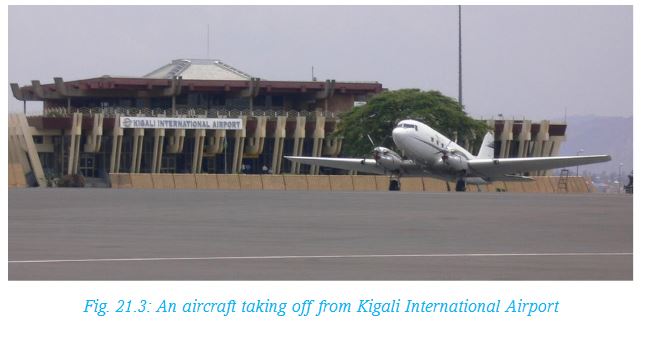
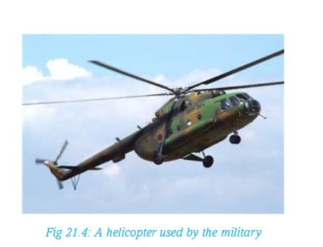
3. Water transport
This involves transportation of passengers and goods on water using water vessels like ships, motorboats and canoes. Large ships are only used where the water is deep. There are fairly large boats on Lake Kivu used by tourists and fishermen. Smaller lakes like Cyahoha and Ruhondo have smaller boats and canoes. There are also canoes that are used by fishermen on some of the rivers in Rwanda.
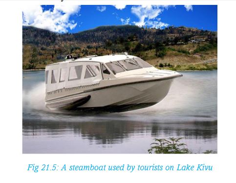
21.2 Communication systems in Rwanda
There are different forms of communication used in Rwanda. The oldest forms of communication include signals such as use of smoke, beating drums, whistling and sending messages by word of mouth. These methods are still used especially where other forms are limited.
Activity 21.4
Carry out a research to find out the following:
1.The different traditional methods of communication used in your local area in the past.
2.Make a list of the modern methods of communication used currently indicating the most popular and why.
Mass communication involves enabling a large number of people to receive the same information. Among the types of mass communication used in Rwanda are:
i.Radio and television
ii. Newspapers and magazines
iii.Telephone services
iv. Internet
v.Postal services
vi. Facsimile
(i) Radio and television
These are electronic media systems. They are effective in sending information to listeners and viewers respectively. They are used for broadcasting news, advertisements, education messages and entertainment. Radios are more widespread even in rural areas of Rwanda because they operate using batteries.
(ii) Newspapers and magazines
These are classified as print media. They are also used for disseminating news, entertainment advertisements and educational messages. In Rwanda, the New Times newspaper is widely read. There are many local and international magazines sold in the towns in Rwanda.
(iii) Telephone services
This is the most widespread of the communication systems in Rwanda. The traditional telephones have fixed lines at certain locations like offices. With the introduction of the mobile phones, almost everyone in Rwanda has a phone and can send or receive messages or make calls wherever there is a network. The service providers are private companies such as MTN Company. Use of mobile phones has made both local and international communication extremely fast.

(iv) Internet
This is a global network of computers linked to each other and enable people to send and receive electronic mails instantly. This method of communication is only available to those with computers and mobile gargets that are connected to the internet.
(v) Postal services
This is a system that enables people to post and receive letters and parcels through the post office. The letters or parcels are carried using transportation means from the post office of the sender to that of the receiver. Postal services enable both local and international communication.
(vi) Facsimile
This is a machine commonly known as fax which sends or receives written information from one person to another where both persons have the machine. The machine uses telephone lines where both machines must be connected. Fax machines are widely used in business transactions.
Activity 21.5
In groups, carry out a research on transport and communication systems used in Rwanda. Choose one type of communication and write a report under the following sub-headings:
1.Type of communication.
2.Economic importance to the country and to individuals.
3.Advantages and disadvantages of using the form of transport and communication.
Present your report for class discussion.
21.3 Advantages and disadvantages of transport and communication systems in Rwanda
Each of the transport and communication systems discussed has its own advantages and disadvantages.
Some of the advantages and disadvantages are outlined below.

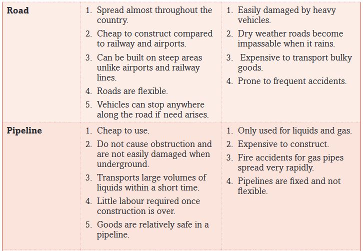
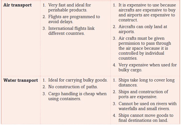
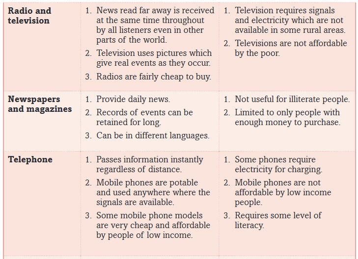
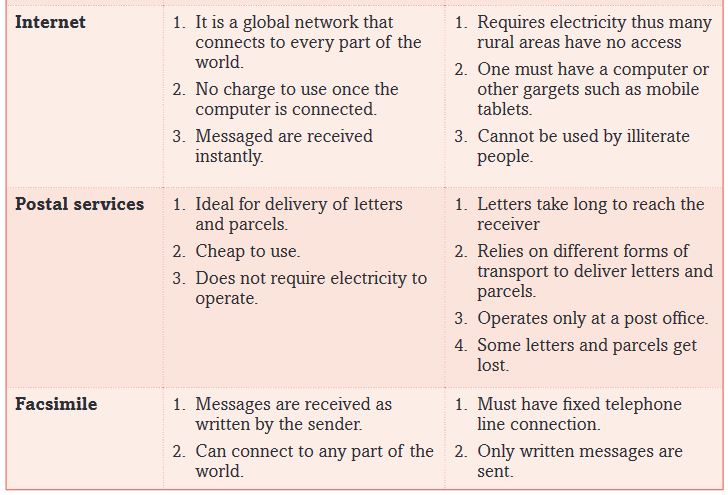
21.4 Problems and solutions of transport and communication in Rwanda
Transport and communication systems in Rwanda are not fully developed. This has a negative effect on the progress in the economic development. There are various challenges that the country faces that hinder development of transport and communication.
Activity 21.6
Assume you are a Rwandan trader who imports cars from Japan to sell locally.
1.Use the atlas to find out the sea port on the coast of Africa that you would use and give reasons for your choice.
2.Suggest the advice you would give to the government that would help reduce the cost of transport from the sea port to Rwanda.
Present your report to the class for discussion.
Some of the problems facing transport and communication sector in Rwanda are outlined below.
1.Rugged landscape
Rwanda’s landscape is dominated by hills. As a result, construction of roads is very expensive. Distances to be covered become long as the road has to wind around the steep parts of the landscape. Other areas require expensive bridges to cross steep valleys. Some of the hills are so steep that only footpaths are found on the sides.
2.Inadequate capital
As a developing country, Rwanda needs to distribute the available funds among all the sectors of the economy. Whatever the transport sector is allocated is not always sufficient. Some is used in repairing the existing roads and constructing earth roads in the rural areas. Many parts of the country are therefore not adequately served.The airfields that serve domestic flights always require repairs and improvement to keep them in usable state.
3.The country is landlocked
Rwanda is a landlocked country. This means that the country does not have a direct access to any sea port on the coast of either Indian or Atlantic oceans. The long distances to the seaports makes transportation of trade goods expensive. In addition, there are delays and charges as the goods cross the borders. This affects the country’s overseas trade negatively.
4. Political unrest in the neighbouring countries
When the neighbouring countries experience political unrest, it is not safe for Rwanda to transport her goods to and from the sea ports through unstable countries. This affects trade with overseas countries.
5. Low levels of income
Many people in Rwanda cannot afford to buy items like computers and televisions because their income is so low.
6. Limited electricity supply
This hinders the use of communication gadgets such as computers and televisions. This is because they operate using electricity. Many rural villages in Rwanda are yet to get electricity.Possible solutions to the problems of transport and communicationThe following are some of the possible solutions:
(i) As a land locked country, Rwanda has to maintain good relationship with the countries through which her overseas trade goods pass. For instance, in August 2013, the president of Rwanda was involved in the commissioning of one of the berths of the port of Mombasa in Kenya as one of the ports that Rwanda uses to carry out her overseas trade.
Activity 21.7
1.Carry out a research to find out which export goods and import goods for Rwanda pass through each of the sea ports the country uses.
2.Explain reasons why Rwanda prefers some sea ports to others for different goods.
(ii) Rwanda needs to borrow loans from international funding agencies such as World Bank and International Monetary Fund (IMF) to use in improving her transport and communication systems. Some foreign governments also give the country grants to use on development projects such as road construction. This can enable the country to expand her road network and improve on the existing ones.
(iii) Rwanda being a member of regional groupings such as the East African Community and Common Market for Eastern and Southern Africa (COMESA), enables her to transport her goods for overseas countries through the member countries with ease.
(iv) Introduction of Information Communication Technology (ICT) in schools is a way of preparing future generations to be able to use modern communication technology easily in future.
(v) By the year 2020, Rwanda government intends to connect electricity to every household in the country. This will enable more people to use communication gargets that operate using electricity.
(vi) Maintaining political stability enables a country to undertake development projects faster. Rwanda has maintained peace for many years and this has helped the government to develop different areas of the economy including the transport and communication sector.
21.5 Trade in Rwanda
Trade is buying and selling of goods. Trade can be very small scale involving local people who buy and sell small quantities of items like vegetables, fruits, sugar or maize flour in the local shopping centres or in the open air markets.
21.5.1 Types of Trade
There are two categories of trade. These are:
(i) Domestic or internal trade
(ii) International trade
(i) Domestic or internal trade
Domestic trade is the buying and selling of goods within the country. Some of the goods sold are locally produced while others may be imported. Domestic trade is in two forms:
(i)Wholesale trade
(ii)Retail trade
Wholesale trade involves buying and selling goods in bulk from a factory or from whole sale shops. The buyers pay for the goods at whole sale price because they buy in bulk.The wholesalers get their merchandise from factories at factory price. Whole sale trade is mainly in urban centres. For instance there are large wholesale shops in Kigali city such as those selling household consumer goods.
Retail trade involves selling and buying goods in small quantities for individual use. The retail trader may have bought the goods from a whole sale shop. A retail trader buys goods in bulk from a wholesale shop then sells each unit separately. For example, the Nakumatt Supermarket in Kigali is a retail shop where goods are sold in single items.
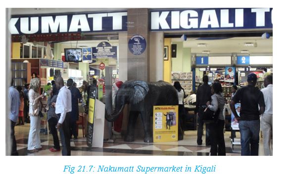
Other retail traders are like the farmers who sell what they have produced from their farms in the local open air markets.
Activity 21.8
With the assistance of your teacher, conduct a field study in the local open air market and make a report of your findings under the following sub-headings.
1. Name of the market and location.
2. Goods sold and where the traders get them from.
3. Types of transport used to carry goods to the market.
4. Categories of people who come to buy.
Share your findings with the other members of your class.
(ii) International trade
International trade involves trade between countries. When the trade is between two countries, it is referred to as bilateral trade. An example is the trade between Rwanda and Uganda. If there are more than two countries involved, it is known as multilateral trade. An example is the trade among the East African Community member states. The goods that Rwanda buys from other countries are the imports like petroleum products chemicals and machinery. The goods Rwanda sells to other countries are the exports like tea, coffee and minerals.
21.5.2 Importance of trade in Rwanda
Trade is very important for the economy of any country. It enables the country and individuals to earn income.
Activity 21.9
In groups, carry out a research on the importance of trade and compile a report for class discussion.
For Rwanda, the following are some of the reasons international trade is such an important sector of the economy.
(i) Rwanda like any other country is not self-sufficient with all the requirements. The country does not produce goods like machinery, petroleum and chemicals. To meet their need, the country must import these items.
(ii) Rwanda requires foreign currency to be able to pay for her imports. The country earns some of the foreign exchange by selling exports like tea, coffee and minerals.
(iii) Maintaining friendly relations with other countries. Trade facilitates good relations between Rwanda and her trading partners both in Africa and the rest of the world.
(iv) It promotes development of transport and communication systems between Rwanda and her trading partners. Rwanda is linked to the neighbouring countries by well-maintained tarmac roads which provide ease in movement of trade goods.
Internal trade is important to both the individual traders and the government.
(i) The government gains by levying taxes on the trade goods. For instance, large scale traders pay income tax for doing the business. The goods sold are charged Value Added Tax (VAT) which is an income for the government.
(ii) International trade encourages good relationship between trading partner countries. Rwanda is friendly to countries that are members of COMESA and East African Community who are her main trading partners.
(iii) Individuals generate income which enables them to improve their standard of living.
(iv) Trade creates employment opportunities where some of those seeking jobs get employed. For instance some people are employed as shop managers, cashiers and shop attendants.
(v) Trade promotes local production of commodities. For example, farmers are assured of market for their produce. This makes them put effort to increase the output.
(vi) Trade encourages development of transport facilities. For instance, feeder roads have been extended to the rural areas in Rwanda to enable farmers to transport farm produce to the markets.
21.5.3 Problems affecting trade and possible solutions in Rwanda
Activity 21.10
Draw a map of Africa showing the position of Rwanda in relation to other countries in Africa.
1.Indicate the sea ports along both the coast of Indian and Atlantic Oceans.
2.Draw the roads that connect Rwanda to the sea ports.
3.Write a paragraph on the sea port you would prefer to use for exports and imports and give reasons for choosing that port.
Trade in Rwanda is affected by a number of factors some of which are outlined below.
(a) The landlocked position
This affects Rwanda’s trade with overseas countries. Goods have to pass through other countries which requires Rwanda to pay certain charges to those countries. In addition, there are delays at the border points as goods have to be checked before they are allowed to pass through.
(b) Long distances to the sea ports
The distances to the sea ports from Rwanda are very long. For example, from Kigali to Mombasa, it is 1477 kilometres while it is 1460 kilometres to Dar-es salaam. As a result, goods take days to be moved from Rwanda to the ports and from the ports to Rwanda by road.
(c) High transport costs
The cost of transporting good to and from the sea ports is very high. This makes international trade for Rwanda very expensive.
(d) Low income levels
Many Rwandans have low incomes. This is a limitation to the local market because many people are not able to pay for certain goods.
(e) Use of different currencies
International trade is transacted using foreign currency. For Rwanda to buy goods from Uganda or Kenya, it has to be converted into international currency, mainly US dollars. The local currency is very weak compared to the US dollar. This makes imported goods expensive to pay for.
(f) Language barrier
Rwandan neighbouring countries such as Tanzania and Kenya use Kiswahili and English to communicate. Many Rwandans are not fluent in the two languages and this makes communication difficult when transacting business between individuals from the different countries.
(g) Poor roads
Murram roads in most rural parts of Rwanda are not usable during the wet seasons. This makes movement of trade goods to markets difficult.
Rwanda and her main trading partners within the Eastern African region produce similar goods. For instance, they all produce sugar, maize, tea and coffee. This limits market for Rwanda’s exports to the region.
Possible solutions to the problems affecting trade
Activity 21.11
In groups, suggest possible solutions for the problems facing trade in Rwanda.Compile a report for presentation in a class discussion.
(i) Rwanda is a member of the regional trading blocs such as COMESA and East African Community. This reduces the cost of trade with the other member countries.
(ii) To improve internal trade, Rwanda has been constructing more roads in the rural areas which can be used all the year round. This is in order to make movement of goods easier for traders.
(iii) Rwanda Government is encouraging the citizens to learn both English and Kiswahili. For example, English has been made the medium of instructions in schools. This will make trading with people from the neighbouring countries easier in future.
(iv) Creating more employment opportunities in the country will enable the local people to be able to buy goods. This is a way of expanding the local market.
21.5.4 Regional and international trade partners with Rwanda
Rwanda’s international trade includes trading with the countries within East and central Africa, the rest of Africa and many other countries in the world.
Activity 21.12
Use the Internet to research on Rwanda’s trading partners in the region and in the rest of the world. Share your findings in class.
The main trading partners in the immediate region are the members of the East African Community. Among them are Kenya and Uganda. Others are Tanzania, Burundi and South Sudan. Rwanda imports as well as exporting her products to these countries.
Within the rest of the African region, Rwanda trades with the COMESA member states which are shown in the map of Africa below.

Rwanda also trades with overseas countries where products that are not available in the African region are imported from. Products like machinery and vehicles are imported from the rest of the world. The main trading partners which provide some of the imports to Rwanda include countries such as China, Germany, United States, United Kingdom, France, Israel, Thailand, Japan and Belgium.
END OF UNIT REVISION EXERCISE
1.Describe the different types of transport and communication systems in Rwanda.
2.Discuss the advantages and disadvantages of:
(i) Air transport
(ii) Road transport
(iii) Telephone
(iv) Radio and television
3.Explain three problems that Rwanda experiences due to being landlocked.
4.Describe the internal types of trade in Rwanda.
5.Explain the problems that Rwanda experiences in carrying out overseas trade.
Unit 22: TOURISM IN RWANDA
Key unit competence
At the end of this unit, you should be able to investigate the impact of tourism on sustainable development of Rwanda.Introduction
Tourism is one of the many economic activities carried out in Rwanda. It involves people travelling within a country or visiting other countries for relaxation or adventure.
Tourism is an important economic activity because tourist from other countries are a source of foreign exchange. Tourists come with money to buy goods and pay for services. Without foreign exchange, a country would not be able to buy imports since they are not paid for using local currency.
Local tourists on the other hand are charged fees as they visit tourist sites. The government gets part of the money through taxes.
To understand more about tourism, this unit covers the following sections:
(i) Definition of tourism
(ii) Tourist sites in Rwanda (historical and natural sites)
(iii) Factors for tourism development in Rwanda
(iv) Importance of tourism industry to the economy of Rwanda
(v) Problems affecting tourism and possible solutions in Rwanda
(vi) Relationship between tourism in Rwanda and regional countries: Kenya, Uganda and Tanzania
22.1 Definition of tourism
Tourism is travelling to visit a place for relaxation, recreation and leisure, usually for a short period of time. When people travel as tourists within their own country, this is referred to as domestic tourism. When people travel to another country as tourists, is referred to as international tourism. Rwanda’s tourist sites are visited by both domestic and international tourists.
Activity 22.1
Study the photograph below and answer the questions that follow.
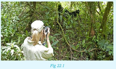
1.Describe what is happening in the photograph.
2.Where in Rwanda is this photograph likely to have been taken?
3.Which other areas in Rwanda have similar tourist attractions?
4.What type of tourism would you classify this to be and why?
5.Describe the tourist attractions shown in the photograph and state why these attractions are so special in Rwanda.
22.2 Tourist sites in Rwanda (Historical and natural sites)
The following map shows the various tourist attraction sites in Rwanda.

Activity 22.2
Using atlases and geographical sources, make a list of things that attract tourists to Rwanda.
Rwanda has different types of tourist attractions which attract both local and foreign tourists. Some of the sites are historical in that they were developed way in the past and have been in existence for many years. Others are natural features which include landforms and wildlife.
Historical attractions
Most of the historical tourist attractions are preserved in museums where they are protected to avoid destruction. Some of the museums are:
1. The National Museum
The museum has information that traces back to pre-colonial history to the modern day Rwanda. It is located in Huye. The museum has a wide collection of information about Rwanda’s culture and history. It also has information of the culture of many other communities in East Africa.
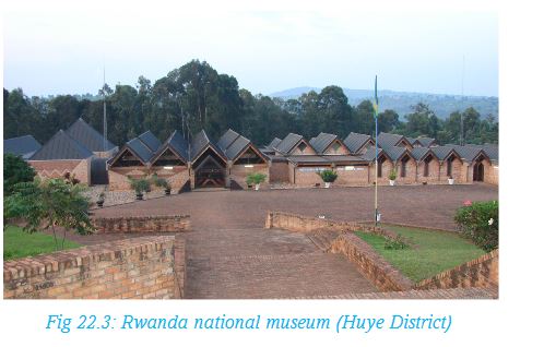
2.Kabgayi Church Museum
This is a huge cathedral near Muhanga. It was built around 1925 by Catholic missionaries. There are other buildings of colonial days in the town.
3.Nyanza Royal Palace
This museum is built using traditional materials. It was the royal place for King Mutara III and his wife Queen Rosalie Gicanda. It is located in Nyanza, about 88 kilometres from Kigali. Within the palace compound, the long horned Inyambo cattle are reared to represent part of the culture of the Rwanda people.
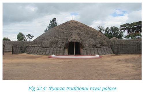
Remember!
When you visit a place you have never been to, you are a tourist whether you are paying or not. There is always something new to learn. Thus you widen your knowledge.
4.The Musanze cave
The cave is located two kilometres from Rubavu road. Local people believe it was built by a local king. However it has a lot of volcanic debris and a volcanic lava bridge indicating that there was massive lave flow from one of the Birunga Mountains. The cave has human remains as a result of the killings that happened there during the 1994 genocide against the Tutsi.
5.Kibeho religious holy place in Nyaruguru district
Kibeho Shrine is a holy place whose history began sometime in 1981 when teenagers reported seeing the image of Mary, mother of Jesus. In spite of the recognition, few outside Rwanda knew of these events. However, word began to spread and followers of Virgin Mary, from near and far, began visiting Kibeho.
Many Christians visit the shrine as pilgrims. Pilgrimage is one of the oldest forms of tourism. It is a journey made by a pilgrim, who travels from place to place, usually journeying a long distance and to a sacred place as an act of devotion. Religious tourism where thousands of people visit holy sites for spiritual fulfillment is rapidly picking up in Rwanda. The ‘land of a thousand hills’ seeks to expand its tourism sector by promoting both local and international pilgrimage in the Kibeho area of southern Rwanda.
Currently, the number of Pilgrims ranges from 25,000-30,000. The Shrine is visited three times in a year.
By formally recognising the area as a religious tourism destination, the country’s tourism industry will now allow tour guides and local safari operators to include Kibeho in their list of places to visit when taking tourists to see the ‘land of a thousand hills’. This is a form of generating income for the people of Nyaruguru District as Pilgrims flock to the Shrine for Ascension Day celebrations.
Activity 22.3
In groups, use geographical documents, maps, photographs and Internet to carry out a research on :
1.The location of the major tourist sites in Rwanda.
2.Classify the sites into historical, natural and others.
3.Establish the estimated number of visitors at each site per year.
4.How do the local communities benefit from the sites?
Natural tourist sites
Natural tourist sites include wildlife conservation sites that have been established as national parks and natural features such as landforms and lakes. Some of these attractions are described below.
(a) Nyungwe Forest National park
The forest is found to south western part of Rwanda and covers over 1000 square kilometres in area. Other than the wide range of plant life, the main tourist attraction in this forest is the wide range of monkey species. They include the chimpanzees, colobus monkeys, owl-faced monkeys, silver monkey and the red-tailed monkey. In addition, the forest has a wide range of birds which attract tourists who love bird watching, the foot bridge and Isumo Falls.
Another attraction in Nyungwe is the extensive Kamiranzovu Marsh.
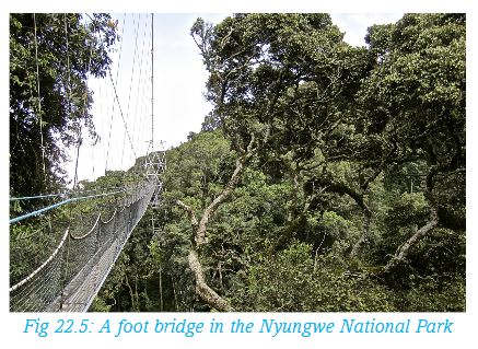
(b)The Volcanoes National park
The park is located to the north-western part of the country. The Birunga volcanic mountains include the Karisimbi, Bisoke, Muhabura, Gahinga and Sabyinyo. Tourist attractions include the mountains themselves and the rare mountain gorilla. Mount Bisoke which is 3711 metres above sea level attracts tourist because it has a beautiful crater lake at the top.
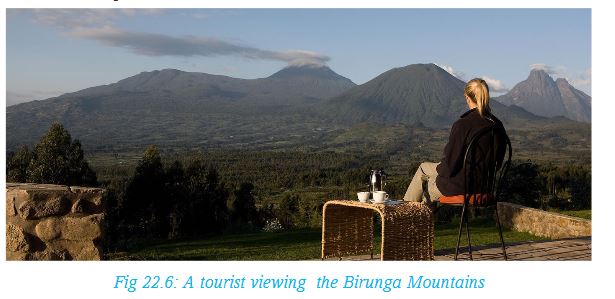
(c) Akagera National Park
The park is found on the eastern part of the country. It has a variety of wild animals including crocodiles and hippos which live in the many lakes. It also has a range of grazing and carnivorous animals that inhabit the savanna grassland areas. Giraffes, elephants, zebras, lions and leopards are some of the tourist attractions in the park.
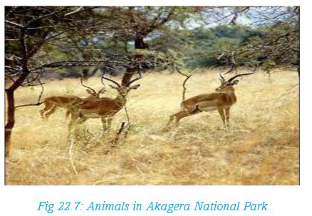
(d) The hilly landscape
Rwanda is described as the “land of a thousand hills.” The landscape has numerous hills forming a scenery which is beautiful to look at.
(e) Lakes
Rwanda has more than twenty lakes, the largest of which is Lake Kivu. It is found along Rwanda’s western border. The lake has some beaches from where tourists have a beautiful view of the Birunga mountains. Tourists are also attracted by water sports such as boating, surfing and swimming on the lake. Other lakes especially those to the eastern part of the country have not only a large population of hippos but also different species of birds.
(f) Rivers and waterfalls
River Rukarara is a tributary of River Nyabarongo. The river starts from Nyungwe forest and flows to join the Akagera which then flows into Lake Victoria from where the Nile flows out. Many tourists are therefore attracted to the River Rukarara since it is considered to be the source of River Nile. The Akagera has the spectacular Rusumo Waterfalls which is visited by many tourists.
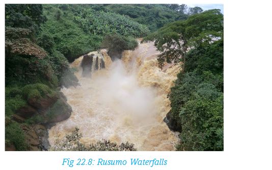
22.3 Factors for tourism development in Rwanda
Every year, Rwanda receives many foreign tourists into the country and there are also local tourists visiting different parts of the country.
Activity 22.4
1.In groups, use geographical documents and publications on tourism to research on the factors that influence development of tourism in the following areas:
• Lake Kivu area
• Eastern Rwanda
• Kigali
• Northern Rwanda
Present your findings for class discussion.
2.Explain how the following factors have led to the development of the tourism industry in Rwanda.
• Political stability
• Existence of varied tourist attractions
• Gorilla naming ceremony
• Advertisement, both local and abroad
• Hotels
• Friendly people
The following are some of the factors that promote the development of tourism in Rwanda:
(a) Political stability
Rwanda has experienced long peaceful period since the wars in 1990. This has enabled foreign tourists to travel to the country without fear of insecurity.
(b) Existence of varied tourist attractions
Rwanda has a variety of tourist attractions. The many museums with unique information and the beautiful countryside are some of the attractions. Another example is the mountain gorilla which is rare elsewhere.
(c) Gorilla naming ceremony
This ceremony is a special tourist attraction. Every year, Rwanda holds a gorilla naming ceremony which attracts many local and foreign tourists.(d)Pub licity and advertisement locally and abroad The government carries out campaigns both locally and abroad creating awareness on the tourist attractions in the country.
(e) Development of tourist hotels
The government and private organisations have constructed high class hotels and lodges in different parts of the country near tourist attractions.
(f) Friendly people
The people of Rwanda are friendly. The hospitality of Rwanda people encourages more people to visit the country.
22.4 Importance of tourism industry to the economy of Rwanda
Tourism is one of the sectors that contributes significantly to the economy in Rwanda. There are many reasons why the governments continues to encourage development of tourism.
Activity 22.5
With the assistance of your teacher, organise a field trip to the nearest museum to study the role of of tourism in the economy of Rwanda. Your report on the field trip should include the following:
1. Name the location of the museum and the year it was established.
2. Items preserved in the museum.
3. Number of employees and their specific roles.
4. Average number of local and foreign tourists vising the museum per year.
5. Charges levied to visitors and average collection per year.
6. The infrastructure development in the area.
Your conclusion should include (i) how the museum benefits the local community and (ii) how it benefits the government.
Present your report to class for discussion.
The tourism industry is important to the economy of Rwanda in the following ways:
(i) Foreign exchange earnings
Tourism is the leading source of foreign exchange in the country. Rwanda needs foreign exchange to be able to pay for imported commodities such as medical equipment, machinery and petroleum.
(ii) Provision of employment opportunities
Through tourism, different types of job opportunities are created. For instance, there are tour companies that employ office workers, drivers and tour guides. Tourist hotels employ many workers while other people who sell local crafts to tourists are self-employed.
(iii) Promotion of local craft industry
Tourists buy different crafts that are made by locals. This improves their livelihoods.
(iv) Improvement of infrastructure
Development of infrastructure, including roads, electricity and provision of clean water to the areas which are visited by tourists promotes development in these areas.
(v) Conservation of wildlife and natural heritage
In order to attract tourists in the country, Rwanda has set aside areas where wildlife is conserved and protected against poachers.
(vi) Preservation of important artefacts
Important artefacts including items that were used in the past are preserved in museums. This is not only for tourists to learn about the history of the people of Rwanda but also for children and future generations to learn the history of their past generations.
(vii) Promotion of development in agriculture
Tourist hotels rely on local farmers to supply foodstuff such as fruits and vegetables. This encourages the farmers to grow the crops to meet the demand.
(viii) Promotion of friendly international relations
Rwanda keeps good relations with other nations. This encourages tourists to feel at ease to visit the country. Good relations also promote trade and cultural exchange.
22.5 Problems affecting tourism and possible solutions in Rwanda
Rwanda has a high potential in tourism which means that the future for this sector is bright. However, development in the sector is slow because there are many challenges that have to be addressed.
Activity 22.6
Below is a list of problems facing the tourism industry in Rwanda. For each problem, suggest the possible solution.
Problems affecting tourism
• Shortage of capital that could be used to expand developments such as roads and accommodation facilities necessary to promote tourism.
• Political conflicts in the neighbouring countries discourage visitors to come to Rwanda for fear that bad people from those countries could escape to Rwanda and cause insecurity in the country.•Increased cases of terrorist attacks internationally has made many people to avoid travelling to other countries simply for leisure. This has affected tourism in many countries including Rwanda.
• Poaching and destruction of environment which has affected some tourist attractions. Some animals migrate further into the forests for safety.
• Poor and underdeveloped infrastructure such as roads. Some areas are too steep for roads to be constructed. This makes some of the tourist sites inaccessible.
• Rugged terrain such as steep slopes in places like Volcanoes National Park. Tourist have to walk long steep distances to be able to reach the sites.
22.6 Relationship between tourism in Rwanda and regional countries: Kenya, Uganda and Tanzania
Rwanda is a member of the East African Community. Other members are Kenya, Uganda, Tanzania and Burundi.
Activity 22.7
1. Using an atlas, draw a map showing the East African Community member countries.
2. Identify and indicate the major national parks in the region.
3. Research and name the types of wildlife in the national parks.
4. Research on the tourists arrivals in each of the countries and discuss how other countries differ with Rwanda.in these arrivals.
Citizens of these countries can acquire the East African passport which gives them free entry into any of the countries. Tourists without passports are also free to use their national identity cards to enter any of the countries. This is a boost to tourism within the region involving citizens of the East African countries. For Rwanda therefore, it will make it possible for the citizens of the other member countries to travel to Rwanda as tourists without paying for visas.
Foreigners wishing to visit any of the East African Community member countries will only require a visa for one country to visit any of the other countries. This will increase the number of foreign tourists into the region. This will be an advantage for Rwanda.
END OF UNIT REVISION EXERCISE
1.Identify the different tourist attractions in Rwanda.
2.Give four reasons why tourism is an important economic sector in Rwanda.
3.Explain the problems that affect tourism in Rwanda and suggest how each can be solved.
4.How does Rwanda relate with the other East African Community member countries in the area of tourism?
GLOSSARY
Afforestation: is the establishment of a forest in an area where there was no previous tree cover.
Anticlines: these are folds in which each half of the fold dips away from the crest.
Aridity: a dry condition that results when there is no rainfall for a long period of time, leading to scarcity of water and massive crop failure and reduced plant life
Bearing: bearing is the direction measured as an angle and given in degrees.
Biodiversity: the variety of life in a particular habitat or ecosystem.
Biogas: is the mixture of different gases produced by the breakdown of agricultural waste, manure, municipal waste, plant material, sewage, green waste or food waste in the absence of oxygen
Catchment area: an area, such as a forested highland area, where sources of water such as rivers originate from
Census: an official counting of people b the government, with details as to age, sex, occupation being taken
Climate: is the average weather conditions of a place recorded over a long period of time, usually between 30 ad 35 years.
Conservation: preservation, protection, or restoration of the natural environment, natural ecosystems, vegetation, and wildlife.
Contour lines: these are lines drawn on a map joining places of the same altitude (that is, height above sea level).
Deforestation: is the permanent destruction of forests in order to make the land available for other uses.
Dereliction: the state of having been abandoned and become dilapidated.
Earthquake: a sudden and violent shaking of the ground, sometimes causing great destruction, as a result of movements within the earth’s crust or volcanic action.
Eastings: they refer to the eastward measured distance (or the x-coordinate).
Epicenter: the point on the earth’s surface vertically above the focus of an earthquake.
Erosion: this is the gradual destruction of soil by natural forces such as water, wind, or ice.
Emigration: this is migration of people from their country to another in order to settle there.
Exfoliation: separation of successive thin shells, or spalls, from massive rock such as granite or basalt.
Faulting: this is the process that causes the fragile rocks of the earth’s crust to fracture and form cracks.
Folding: this is the bending of the rocks of the earth’s crust due to compression forces operating within the earth’s surface.
Foreground: the foreground is the area that is nearest to the camera. Objects in this area are always bigger and clearer than those in background.
Global warming: is the term used to describe a gradual increase in the average temperature of the Earth’s atmosphere and its oceans, a change that is believed to be permanently changing the Earth’s climate.
Human portage: A form of transport where people carry goods on the head, shoulder or back, or simply with their hands from one place to another.
Inceptisols: a soil formed in the highland areas through quick weathering of the parent rock material of an order comprising of freely draining soils in which the formation of distinct horizons is not far advanced, such as brown earth.
Immigration: this is the migration of people into a given country.Impoverishment: the state or fact of being extremely poor.
Irrigation: the artificial application of water to the land or soil. It is used to assist in the growing of agricultural crops, maintenance of landscapes, and re-vegetation of disturbed soils in dry areas and during periods of inadequate rainfall.
Kaolisols: is soil that is formed on weathered parent material which is mainly made of clay with little silica under the heat and heavy rainfall
Landslide: the sliding down of a mass of earth or rock from a mountain or cliff.
Lava: hot molten or semifluid rock erupted from a volcano or fissure, or solid rock resulting from cooling of this.
Magma: is the molten rock originating from the upper plastic layer of the mantle. When it gets to the surface and loses its gases, it is known as lava.
Mass wasting: this is the process by which soil, sand and rock move down slope in a mass form.
Mining: is the extraction of valuable minerals or other geological materials from the earth from an ore or other valuable deposits.
Non-renewable resources: aresourceof economic value that cannot be readily replaced by naturalmeanson a level equal to its consumption.
Northings: they refer to the northward measured distance (or the y-coordinate).
Nucleated settlement: to form into a nucleus or cluster.Oxidation:is a form of weathering where rockminerals, especially iron, react with oxygen leading to a change in the mineral composition of therock and eventual breakdown or weathering
Pastoralism: this is the branch of agriculture concerned with the raising of livestock.
Ranching: is the practice of raising herds of animals on large tracts of land.
Reforestation: is the reestablishment of forest cover, either naturally (by natural seeding, coppice, or root suckers) or artificially (by direct seeding or planting).
Rehabilitation: the act of restoring something to its original state.
Relief: this refers to the general appearance of the landscape, that is, how hilly the land is.
Renewable resources: substances of economic value that can be replaced or replenished in the same amount or less time as it takes to use it.
Seismic focus: the place of origin within the Earth of an earthquake; usually some more or less restricted area of a fault surface. If the focus is to be some particular point, it is the central point of the area over which fault movement occurred and caused the earth quake
Seismograph : an instrument that measures and records details of earthquakes, such as force and duration.
Solifluction: the gradual movement of wet soil or other material down a slope, especially where frozen subsoil acts as a barrier to the percolation of water.
Spot heights: it is an exact point on a map with an elevation recorded beside it that represents its height above a given area. On a topographical map, it is shown as a circle and a dot inside.
Subsistence farming: is where farmers focus on growing enough food to feed themselves and their families, with the output being mostly for local consumption with little or no surplus for sale.
Sustainable: able to be maintained at a certain rate or level.
Synclines: these are folds in which each half of the fold dips toward the trough of the fold.
Tourism: this is travelling for pleasure. It is the business of attracting, accommodating, and entertaining tourists, and the business of operating tours.Tourism may be international, or within the traveler’s country.
Trapezium: thisis a quadrilateral that has only one pair of parallel sides.
Trigonometric stations: these are points on the earth’s surface constructed on the highest points of prominent hills.
Urbanisation: is the movement of people from rural to urban areas leading to a gradual increase in the proportion of people living in urban areas
Umudugudu: the smallest administrative unit in Rwanda. A village
Viscous lava: thick, molten rock materials from underground that can flow on the earth’s surface.
Volcanicity: All the processes associated with the transfer of magma and volatiles from the interior of the Earth to its surface.
Vulcanicity: is the process through which gases and molten rock are either extruded on the earth’s surface or intruded into the earth’s crust.
Warping: this is the bending or curving of the surface due to forces acting inside the earth’s surface
Weather: Is the condition of the atmosphere at a particular time
Weathering: this is the process by which rocks are increasingly broken into small particles.
REFERENCES
1.Adimola, B., Gahima, C., Kivuva, M., & Mmbando J S (2006). Atlas for East Africa. Longman: Harlow.
2.Buckle, C. (2007). Landforms and landscapes in Africa. An introduction to geomorphology. Edinburgh: Pearson Education Limited.
3.Bunnett R.B. (2004). Physical geography in diagrams for Africa. Longman.
4.Crispin, J., &Jegede, F. (2000). Population, Resources and Development. London: Collins Publishers.
5.Dove, J., Guinness, P., Martin, C., Nagle, G., Payne, D,.& Witherick, M. (2008). Geography. Edinburgh: Pearson Education Limited.
6.Faniran A. & Ojo O. (1980). Man’s Physical Environment. London: Heinemann Educational Books Ltd.
7.Gotanegre J.F. &Prioul C, Sirven P. (1974). Géographie du Rwanda. Bruxelles: éd. A. De Boeck.
8.Larousse (2000). Encyclopédie des Jeunes Larousse. France: La terre, une planète active.
9.Le Callennec, S. (1997). Histoire géographie, 8ème année. Paris: Hâtier.
10.Le Callennec, S. (1997). Histoire géographie, 9ème année. Paris: Hâtier.
11.Le Callennec, S. (1997). Histoire géographie, 10ème année. Paris: Hâtier.
12.Leong, G.C. (1996). Certificate physical and Human Geography. Hong Kong: Oxford University Press.
13.Master, D.N. (2000). Map Reading for East Africa. Edinburgh: Longman.
14.McMorgan, G. C., & Leong, L. G. (1982). Human and Economic Geography, 2nded. New York: Oxford University Press.
15.Minns W. J. (1984). A geography of Africa. Macmillan.
16.Monkhouse, F. J. (2008). Principles of Physical Geography. London: Hodder Education. 124
17.Monkhouse, F. J. (2007). A Dictionary of Geography, 2nded. New Brunswick, USA: Transaction Publishers.
18.National Curriculum Development Centre (2008). Ordinary Level Geography Curriculum for Rwanda. Kigali: NCDC.
19.NCDC. (2013). The Uganda Advanced certificate of Education: Teachers Syllabus for Economics, Geography and History. Vol.
20.Needham. (2003). Africa, Asia and Australia. Massachusetts: Pearson Education.
21.Senior, M. (1987). Tropical Lands: A Human Geography. Essex, England: Longman Group UK Limited.
22.Singapore Ministry of Education (2006). Geography Syllabus Lower Secondary.
23.The National Curriculum. (1999). Handbook for Secondary teachers in England Key stages 3 and 4. London:
24.Department for Education and Employment. Waugh, D. (2003). The new wider world, Second Edition. United Kingdom: Nelson Thornes.
25.Whitton, J. (1984). The Penguin Dictionary of Physical Geography: Great Britain: Penguin Books.
26.Winfred, W. (2006). Mastering Photograph Work KCSE Geography. Longhorn Publishers Limited: Kenya.