General
- Geography S2 SB File Uploaded 24/01/22, 16:02
- S2: Geography TG File Uploaded 11/08/22, 21:52
Unit 6: RELIEF IN RWANDA
Key unit competence
At the end of this unit, you should able to distinguish different forms of relief features of Rwanda and their relationship with human activitiesIntroduction
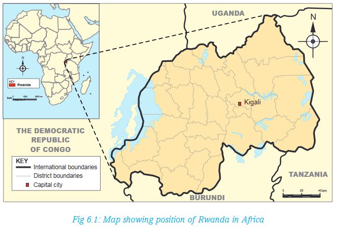
Rwanda is one of the fifty four independent countries of Africa. It is in the central part of the continent within the great lakes region.
6.1 General presentation of Rwanda
a) Location of Rwanda
Activity 6.1
1. Using the Atlas, draw a map of Rwanda. Indicating the neighbouring countries.
2. On the map, show the major latitudes and longitudes that pass through or near Rwanda.
3. Discuss the challenges that Rwanda faces as a landlocked country.
Rwanda is a small landlocked country located in the Great Lakes region of east and central Africa. The country lies between 1°04’ and 2°51’ latitude south of the Equator and between 28°53’ and 30°53’ longitude East of Greenwich Meridian. Rwanda’s northern neighbour is Uganda, to the south is Burundi, to the west is the Democratic Republic of Congo and to the east is Tanzania.
b) Size of Rwanda
Rwanda’s total area is about 26,338 square kilometres. The country is smaller than the neighbouring countries. It is the smallest country in Eastern and Central Africa. The water surface occupies about 1,668 square kilometres while the land surface is 24,670 square kilometres.
Activity 6.2
Using your atlas or information from the Internet:
i) Find out the sizes of Rwanda’s neighbouring countries.
ii) List their sizes in your notebooks. Start from the smallest to the largest. What is the last country on your list?
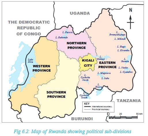
c) Administrative sub-division of Rwanda
Activity 6.3
1. Draw a map of Rwanda showing the districts and major towns in each district.
2. Find out the largest and the smallest district in Rwanda.
3.Draw a table showing where your home and school is, by completing the following chart:

Rwanda is sub-divided into thirty districts. The districts are found in five provinces.
The districts are further sub-divided into sectors, cells and villages.
d) Population of Rwanda
Population refers to the number of people in a given area.
Dorothy has been having seven grandchildren. She has just seen her eighth grandson being born. Her third born son, Gahizi, got married fifteen months ago in a church wedding. Six of her eight children, including Gahizi, have completed school. Three of them already have formal employment. The other two are businessmen while the last born daughter just graduated from university. She remembers clearly when she was young. People used to have large families.
When her grandchildren visited her during the last holidays, she narrated to them how life was in the past. When she tried to compare to what it is now, she also got surprised. There are many people now, with not so much land to settle on. “People have increased to almost double since I was your age,” she once said during their evening story time.
Activity 6.4
1. From the above story, explain the reasons that have caused population increase.
2. In groups of four, use the Internet and other Geographical documents to:
a) Compare the total population of Rwanda as per the 2002 and 2012 census.
b) Explain possible factors that cause a difference in settlement in different parts of the country.
Today, Rwanda is estimated to have 11.5 million people. Many people live in the central part of the country. Here, the density ranges from 250 to 380 people per square kilometre. The density in the east and south west is less than 250 people per square kilometre.
Rwanda’s life expectancy in 2015 was 66.7 years for adults. For male population, the estimate is 65.2 years while for female population it is about 68.2 years. Interesting to note, however, is that the life expectancy of a Rwandan rose from 51 years in 2002 to 66.7 years in 2015.
Source: National Institute of Statistics of Rwanda, 2016
6.2 Rwanda, a landlocked country
Definition
A country is landlocked when it is surrounded on all sides by a country or countries and therefore has no direct access to a coastline. To access the coast of the nearest oceans, people from the landlocked country have to pass through other countries.
Activity 6.5
1.Using an Atlas, list all landlocked countries in Africa.
2.Use Internet search to find out three countries landlocked by a single country.
Disadvantages of being land locked
Activity 6.6
Read the following passage on the disadvantages of a country being landlocked. Afterwards, answer the questions that follows.
Historically, being landlocked has been disadvantageous to a country’s development. It cuts a nation off from such important sea resources as fishing. It also impedes or prevents direct access to sea trade. It is because of this reason that coastal regions are mostly wealthier than other areas inland. These areas are also more heavily populated than inland ones.
Landlocked developing countries have significantly higher costs of international cargo transportation compared to coastal developing countries.
Due to their remoteness, landlocked countries are dependent on neighbouring transit countries for their external trade and suffer from high trade transaction costs. Huge transport costs, inadequate infrastructure and challenges associated with importation and exportation requirements can be a serious hindrances to their integration into the global economy, impairing export competitiveness or the inflow of foreign investment.
Source: Wikipedia
From the passage above:
1. Discuss the disadvantages of a country being landlocked.
2. In groups of five, discuss whether the following statement is true or not.
Choose one of you to present your findings to the class.
Possible solutions of being land locked
a) Rwanda has made agreements on getting lower transport charges for goods through neighbour countries.
b) The United Nations has a law that protects landlocked countries from high taxation. The law gives these countries a right of access to and from the sea without taxation of traffic through transit states.
c) Rwanda is improving the quality of roads, which is part of Vision 2020. In partnership with neighbouring countries, Rwanda is expected to directly benefit from the Northern Corridor. This is the busiest and most important route in east and central Africa. It provides a gateway through Kenya to the landlocked economies of Uganda, Rwanda, Burundi and eastern Democratic Republic of Congo. It also serves South Sudan.
d) The government is improving energy supply and Internet access to improve the flow of information.
e) There has been efforts to reduce the time it takes to travel along the main roads to enable goods to move between 300km and 400km in a 24-hour period.
f) Landlocked countries like Rwanda depend on good political relations with transit countries. If a landlocked country and its transit neighbour are in conflict, the transit neighbour can easily block borders or adopt regulatory impediments to trade. Even when there is no direct conflict, landlocked countries are at a disadvantage due to the political problems of their neighbours.
6.3 The major forms of relief in Rwanda
Activity 6.7
1. List some of the relief features in Rwanda.
2. Draw an outline the map of Rwanda. On it, show the relief regions you have mentioned in the question above. Make sure that the sketch map has all the qualities of a good map, that is, the key, frame, title, compass direction and scale.
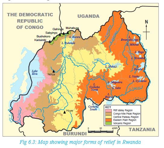
Relief is the general appearance or the nature of the landscape. The Rwandan relief is hilly and mountainuous with an altitude varying between 900 metres and 4,507 metres above sea level. In general, there are five major forms of relief that can be shown on the relief map of Rwanda. These are:
a) The mountainuous region
b) The plateau region
c) The plains region
d) The Rift Valley region
e) The Congo-Nile Peak region
Each of these regions is discussed below:
(a) The volcanic region – This region lies above 3,000 metres above sea level. The highest altitude is 4,507 metres above sea level, which is the peak of Mt Karisimbi. The region is dominated by mountains of volcanic origin, including Karisimbi, Muhabura, Bushokoro, Gahinga and Sabyinyo.Due to its high altitude, it experiences cool and wet climate. The soils, which are of volcanic origin, are usually fertile. These factors have greatly contributed to settlement and various agricultural activities in the region.
(b) The plateau region – It consists of gently sloping hills and long u-shaped valleys. Its altitude ranges between 1,500 metres and 2,000 metres above sea level. The region stretches as far north as Gicumbi and as far south as Huye.
(c) The plains region – Also called the Eastern Savanna, the region is found farther east from the Central Plateau. Its altitude averages 1,280 metres above sea level. Rusizi Plain and areas around Lake Kivu are also on a plain. Bugarama is the lowest part of the country, and is in this region, at a height of approximately 900 metres above sea level.
(d) The Rift Valley region - This region lies on the western border of the country. It is also known as the Albertine Rift valley region. The region is part of the western branch of the Great Rift Valley which runs from the Middle East to southern Africa. It is part of the tectonic depression of the African Rift Valley.
(e) The Congo-Nile Peak region - This is a region found in the west of Rwanda. It lies between 2,500 m and 3,000 m above sea level. The region crosses the rift valley along the line of the Virunga Mountains to the north of Lake Kivu. It creates a divide between the waters of Nile River and the waters of the River Congo. Rivers flowing to the west form the tributaries of the Congo River while rivers flowing east enter Lake Victoria and the Nile River.
Activity 6.8
Identify the provinces in Rwanda where the above mentioned relief features are found.
Did you know?
In 1992, the Volcanoes National Park, which is found in the volcanic region in Rwanda, became a battlefield during the Rwandan Liberation War, with the park headquarters being attacked and the research centre was abandoned. This led to the stopping of all tourist activities including visiting the gorillas. Tourism activities were resumed in July 1999 when the area was deemed to be safe and under control. Since then, the number of visitors traveling to the Birunga had greatly increased.
Advantages of relief features in Rwanda
Activity 6.9
Read the following story then answer the questions that follow:
In her Geography lesson, Ms Hakizimana of Kagarama School was to teach about advantages and disadvantages of relief features in Rwanda. She took the learners under a tree where she started by saying:“Farming takes place in highland areas, though it should carefully be done to avoid soil erosion and degradation. This is why terracing is done in such areas to prevent the loss of the fertile top soil,” she said.
She then asked her learners to describe human activities in the areas where they come from. The following were the learners’ responses:
Kamagaju: Our home is on the plains that border Nyabarongo River. Here, people cultivate crops because they say the soil is deep and fertile.
Ngoga: I come from Karongi District, near Lake Kivu. Some people around the lake practice mining near the beaches because the area has alluvial minerals.
Kabano: Roads to our rural home in Gicumbi goes around some of the hills they are constructed on. Due to this, motor taxis say driving fast on such roads is dangerous.
Ntawizerakundi: I have grown up in Kigali. I have friends in Kiyovu, Nyarutarama, Rebero and Kacyiru. Sometimes, I visit them. I believe people are settled in these places because Kigali and its surrounding areas are on gentle slopes.
Gasaro: I saw Rwanda Telecommunication service vans climbing the hills near our home to repair the communication masts on Kagarama hills. One of them was overheard saying that they were to proceed to the station on Mt Karisimbi afterwards, before going back to the office.
Teta: My uncle, a lecturer at the University of Rwanda, once told me that there are no settlements on the slopes found in places such as Sabyinyo, Karisimbi, Bisoke, Gahinga and Muhabura.
Cyubahiro: My guardian is an agricultural extension officer. She told me that on the leeward slopes of the places Teta has mentioned are unsuitable for crop farming.
Mugisha: The water we use at home comes from the water tanks mounted on a nearby hill. The water is also used throughout our district. It is said that these tanks, which are on a hilltop, supply water to the district using natural gravity.
Mwiza: The road constructed on the plains where Kigali International Airport was built passes near our home.
Nziza: Poor farming methods in our neighbourhood in Rusizi caused soil erosion. This is because the land is hilly. However, people practice contour farming nowadays to prevent further loss of fertile top soil.
From the discussion above, mention both the advantages and disadvantages of relief in Rwanda.
Remember!
Farming on the slopes can easily trigger soil erosion. It is therefore important that farmers engage in modern methods of farming that promote continued use of the soil. This can be achieved through ploughing across the contours. This is one of the sustainable farming methods, which is a way of conserving the environment.
Disadvantages of relief features in Rwanda
a) Building roads, railways, electricity lines, data cables and coming up with different forms of infrastructure on sloping land is expensive. This is because the land needs to be flattened before construction. Roads constructed on steep slopes are winding in nature. Such areas include Kabale.
b) Inappropriate farming methods on hillsides and mountain slopes can trigger soil erosion, causing loss of the fertile top soil. Landslides and are also a potential risk in slopy areas.
c) Thick vegetation on the sides of some hilly and mountainous areas discourages settlement. For instance, there is no human settlement on the slopes of mounts Sabyinyo, Karisimbi, Bisoke, Gahinga and Muhabura.
d) The low temperatures experienced on some of the mountains such as Sabyinyo, Karisimbi, Bisoke, Gahinga and Muhabura make human habitation impossible. On the other hand, the leeward sides of the mountains are unsuitable for crop farming. These areas experience low temperatures and rainfall respectively.
6.4 Relationship between relief and human activities (Land use in Rwanda)
Relief determines the way people make use of that land.
Activity 6.10
In groups, use maps, geographic information and the Internet to find out the human activities in Rwanda.
What is the relationship between the human activities and relief?
Mountain slopes and hillsides are set aside for forestry and for conservation of wildlife. An example is the Birunga National Park. This promotes tourism. Where natural forests have been cleared, for example in Gishwati forest, more trees have been planted as a form of environmental conservation.
On the other hand, farming takes place on broad valleys such as Nyabarongo (sugarcane), Nyacyonga (rice) and Akanyaru in Gisagara and generally in Kigali where vegetables and rice are grown.
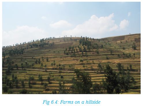
In most cases, people avoid land that has steep slopes because it is not suitable to establish settlements, farms or roads and railways. Steep land is only used if people have no other areas to make use of. For instance, in some parts of Rwanda, people have farms that are on hillsides because the land is hilly. They farm using contour method to avoid soil erosion. Crops like tea is grown on sloping land where soil is well drained.
Adapted from Rwanda State of Environment and Outlook Report (2009) - By REMA
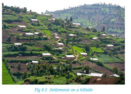
The photograph below shows farms on a hilly area in Rwanda.
Building houses on sloping land is also expensive because one has to make some flat surface where the house will stand. There are many settlements on hillsides in Rwanda. It is also very expensive to build roads on land that is steep.
Remember!
Human activities such as farming and settlements are more common on land that is gently sloping or flat because it is easy to set them up. Steep mountains and hillsides are set aside for forestry and for conservation of wildlife. Where natural forests have been cleared, more trees have been planted as a form of environmental conservation. Such areas include Gishwati Forest, whose forest cover has been restored after extensive deforestation in earlier years.
END OF UNIT REVISION EXERCISE
1. What is the meaning of the term ‘relief’?
2. What are some of the relief features in Rwanda?
3. On what type of relief do people practice contour farming and why? Give examples of such areas in Rwanda.