General
- Geography S2 SB File Uploaded 24/01/22, 16:02
- S2: Geography TG File Uploaded 11/08/22, 21:52
Unit 4: TECTONIC PROCESSES
Key unit competence
At the end of this unit, you should be able to explain the tectonic theory that has shaped the landscape we see.4.1 Introduction to landform processes
Read the following story.
Gladwel was travelling to her parent’s home in Rusizi. On the way, she saw many physical features. She saw hills, valleys, plains and mountains. She also saw rivers flowing within the valleys and forests growing on the slopes of hills. At some point, the road was winding up or down a certain hill. In such areas, the driver of the bus drove carefully. Areas that were on the plains had many human activities such as farming and trade.
Suddenly, she remembered what her Geography teacher once said: “If you look around your school or home, you will see various features on the surface of the earth. Some of these features may be found on your way to school, church or mosque. When you travel from one place to another, you may see these features or even more.”
In the story above, Gladwel observed some of the physical features on the earth’s surface.
Activity 4.1
Name the physical features Gladwel observed.
The features you have named above occur as a result of tectonic movements.
Activity 4.2
Using the Internet and other geographical materials, define the term tectonic movements.
The internal landform processes are caused by:
a)Tectonic processes
b)Tectonic forces
c)Tectonic movements
Activity 4.3
Differentiate between the three terms mentioned above.
Internal land-forming processes (or tectonic processes) are those processes operating inside the earth. These processes result in the formation of features on the surface of the earth. They are caused by tectonic forces. This results into tectonic movements. Tectonic movements can be horizontal (lateral) or vertical. They cause the following processes to occur within the earth, namely:
(i) Folding
(ii) Faulting
(iii) Warping
(iv) Vulcanicity
(v) Earthquakes
Activity 4.4
In groups of five:
1.Discuss the meaning of each of the terms given above.
2.Some of the resultant effects of earth movements are dangerous to life. Using examples, explain how true this statement is.
Pick one amongst yourself to present the findings to the class.
4.2 Folding
In this section, we will explain the following concepts:
• Meaning of folding
• Causes of folding
• Resultant features of folding
• Examples of areas of folding
• Effects of folding
4.2.1 Meaning of folding
Activity 4.5
In groups, use a paper to illustrate how folding takes place. Place the paper on the table then push from both ends inwards.
Explain what you see.
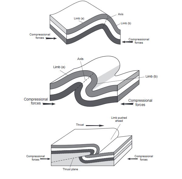
Folding is a process that occur within the rocks of the earth’s crust. This process causes the rocks to bend upwards or downwards. The process is caused by tectonic forces that operate horizontally within the earth’s crust.
Activity 4.6
Identify what the paper in Activity 4.5 above represent.
Just like the paper in Activity 4.5, when tectonic forces move towards each other, they cause the rocks in between the forces to be compressed. This means, they get squeezed and in the process, these rocks bend upwards and downwards. The forces acting in this manner are referred to as compressional forces.

The parts of the earth that bend upwards are called anticlines or upfolds. Those parts that bend downwards are called synclines or downfolds. The amount of folding in the rocks and the features that result from it depend on the strength of the forces involved. This in turn determines the nature of the features that form on the surface of the earth.
4.2.2 Resultant features of folding
The process of folding causes sizeable features that can be seen on the surface of the earth. The most common features resulting from folding are fold mountains. They form the world’s highest mountains.
Other resultant features of folding are:
• Inter-montane (or intermont) plateaus
• Valley and ridge landscape
• Rolling plains
• Fold mountains
• Inter-montane (or intermont) basins
Activity 4.7
1. Each of the terms give above is explained below. Match each explanation with the term it is referring to.
(a) They result when weak compressional forces transform the relatively flat lowland into very gentle low anticlines and broad but gentle synclines.
(b) This landscape is made up of a series of high anticlines and deeper synclines. Forces that are uneven in strength cause anticlines to form ridges with one side being gentle while the opposite side is steeper.
(c) They are relatively level surfaces of considerable extent, that lie high up within the fold mountains and are surrounded by higher mountain peaks. They represent areas that resisted folding when compression forces were at work. The surrounding areas however, were folded and rise up above these surfaces.
(d) They are depressions on the surface of inter-montane plateaus. They were formed during the formation of the plateaus when some parts of these plateaus subsided and ended up as basins.
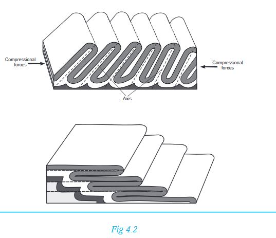
2. Look at the following illustrations. They represent the various types of folds. Identify the type of fold each illustration is showing from the list given below.
• An asymmetrical fold
• An overfold
• A recumbent fold
• An overthrust fold
• Isoclinal folds
4.2.3 Areas of folding
Many areas that have experienced compressional forces display rocks that have undergone folding. However, the most conspicuous features are fold mountains.Therefore some examples of areas of folding are those where fold mountains occur. Examples of fold mountains include Atlas Mountains in northwest Africa, Cape Ranges and Drakensburg in South Africa and Folded hills in the Eastern Province of Rwanda.
Activity 4.8
In pairs, use an atlas or information from the Internet to identify areas in Rwanda where folding has taken place. Find out if there are fold mountains in Rwanda. Write your findings for further discussion in your discussion groups.
4.2.4 Effects of folding
Activity 4.9
In pairs, read the following effects of folding. Categorise each of them either as a positive or negative effect. Give reasons for your answer.
(a) Severe folding distorts the land turning it into a rugged landscape that is unsuitable for farming and settlement.
(b) During folding, valuable minerals could be brought closer to the surface, making their mining easier. However, some valuable minerals could also end up being buried deep and therefore inaccessible.
(c) The process of folding weakens the crustal rocks causing them to develop cracks. These provide weak areas through which molten magma can escape from the interior of the earth thus triggering volcanic activity.
(d) Fold mountains form a barrier to transport and communication.
(e) The mountains, especially in the olden days, formed a protective barrier against enemies on the opposite side.
(f) The mountains formed from folding modify the climate of the area where they exist. Some areas receive abundant rain while others receive less. Higher areas are cooler than lower areas.
(g) Mountains are a good water catchment area and are therefore a source of rivers whose water can be utilised in various ways in the surrounding areas and far places.
The scenery created by fold mountains is unique and attractive to look at. Therefore, fold mountain areas are a tourist attraction.
4.3 Faulting
Activity 4.10
In groups of five, use a ruler to explain how faulting takes place. Place the ruler on the table then push from both ends inwards. Explain what you see.
The ruler used in the activity above will break when compressed from both ends. This illustrates what faulting is.
Faulting is the process that causes the fragile rocks of the earth’s crust to fracture and form cracks. This process is caused by tectonic forces that act horizontally or vertically within the earth’s crust. As the rocks are folded due to compressional forces, cracks do form within the folding rocks because rocks are quite rigid and therefore do not bend like rubber. These cracks are called faults.
Activity 4.11
In groups of four, collect clay or plasticine and mould ribbons with it. Pull the ribbons and explain what happens.
The force you applied to the plasticine or clay is similar to horizontal forces within the earth’s crust. These are called tensional forces. These forces cause the affected rocks of the earth to stretch and sometimes even break. The parts of the resultant feature is as shown below:
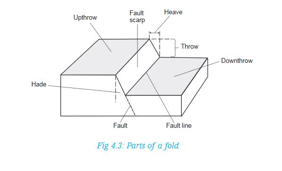
4.3.1 Types of faults
The process of faulting causes various types of faults to occur within the rocks. The types of faults that form are largely influenced by the way tectonic forces that cause them, operate. The following are common types of faults:
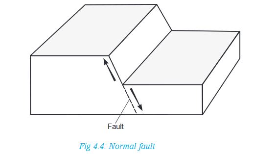
(a) Normal faults: These are faults that result from tensional forces. As land is pulled apart, one block of land slides downwards against the other one. These faults have formed in the East African Rift Valley.
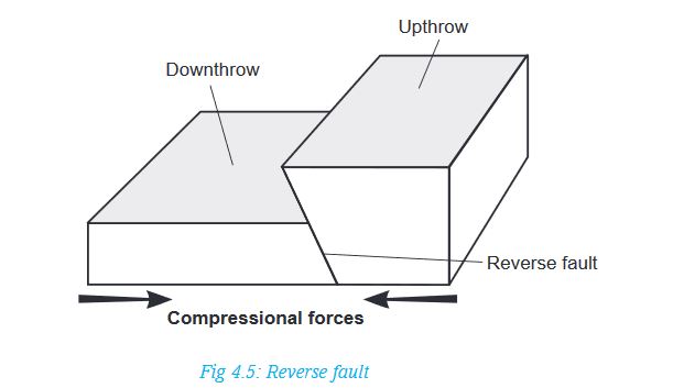
(b) Reverse faults: These are also known as reversed faults. They are caused by compressional forces. A fault occurs where the forces push towards each other and one block of land on one side of the fault is pushed up over the other.
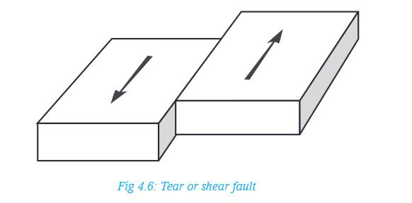
(c) Tear or shear faults. These are also known as strike-slip or wrench faults. They are a product of two opposing forces which move parallel to each other. A fault forms in the region separating the two forces and the blocks of land on both sides of the fault slide past each other. In this situation, land is displaced horizontally. Very extensive shear faults across continents are called transform faults and are associated with tectonic plate boundaries.
Activity 4.12
In groups of four, discuss and compile the findings on how the following types of folds occur.
• Thrust faults
• Anticlinal faults
Draw diagrams to represent the two types of faults. Prepare a class presentation.
4.3.2 Landforms resulting from faulting
The following are some examples of the landforms that result from faulting:
• Escarpments
• Fault steps
• Rift valleys
• Fault blocks
• Tilt blocks
Activity 4.13
Use geographical documents, the Internet and diagrams to find out the mode of formation of the various features resulting from faulting. In groups, discuss the processes of formation of different relief features. Present your findings to the class. In your presentation, include:
(a) How each feature is formed
(b) Examples of these features
(c) Diagrams to show how each of them is formed
4.3.3 Areas of faulting
Faulting and the resultant features are associated with areas where folding has taken place. In East Africa, areas of faulting are mainly within the Great Rift Valley region. This region starts from Syria, through the Red Sea, Ethiopia, Kenya, Tanzania, Malawi and Mozambique. It has a branch from Lake Rukwa area in Tanzania, past Rwanda into western Uganda.

4.3.4 Effects of faulting
The process of faulting and the resultant features have an impact on both human and physical environments. The effects can have a positive or negative influence. Some of these effects are:
(a) Faulting causes disjointing of land. This leads to interruption of transport lines such as railways, roads and pipelines. Even construction of such lines is difficult across escarpments.
(b) When land subsides after faulting, many people may die in the process when buildings collapse on them or when they are buried alive in the resulting fractures.
(c) When faulting occurs across a river valley, it can cause a river to change its direction of flow or even disappear into the ground along the fault.
(d) In some regions where faulting has occurred, the fractures may extend deep down into the earth. These fractures may form easy passage for hot water or steam to come to the surface. This results into geyser and hot springs that can be harnessed for production of geothermal electricity.
Activity 4.14
In pairs, discuss other effects of faulting. Use geographical documents, the internet and atlases.
4.4 Warping
This is a process involving a gentle deformation of the earth’s crust over a considerable area. The landforms associated with warping are few. Common ones are:
i) Broad shallow basins
ii) Low uplands or hills
Areas of warping in Africa
1. In East Africa, large scale warping occurred in central Uganda where it formed the current Lakes Victoria and Kyoga basins.
2. The western side of the plateau upwarped to form highlands in western Uganda and eastern Rwanda.
3. In eastern part of Rwanda, downwarping occurred in some areas that resulted in the formation of relatively large basins where water accumulated to form lakes such as Lake Muhazi.
4. In western Kenya, south eastern Uganda and north eastern Tanzania, minor upwarp occurred to form the Lake Victoria basin.
5. The Lake Victoria basin also tilted slightly northwards towards Lake Kyoga. Water that overflowed from Lake Victoria ended up in the Kyoga basin.
6. Downwarping also created several smaller basins on the plateau. Many of these also formed lakes such as Nakivali, Kachira and Wamala in the west as well as Bisina and Opeta in eastern Uganda.
Activity 4.15
In pairs, draw the map of Africa. On it, mark the areas where downwarping has occurred. Show the features that have formed in these areas.
4.5 Vulcanicity and volcanicity
Activity 4.16
Using a dictionary, differentiate between:
a) Vulcanicity and volcanicity
b) Magma and lava
Write short notes about each term. Present your findings to the class.
4.5.1 Causes of vulcanicity
The earth has seven continents. Our country Rwanda, is in Africa, which is one of the seven continents.
In pairs, name the other six continents.
Each continent is carried by large, rigid blocks called tectonic plates. These plates float on hot and softer layers found inside the earth. The plates also move on these softer layers, towards each other, past each other or away from each other. Vulcanicity is usually associated with these plates.
There are three main causes of vulcanicity. These are:
a) Where tectonic plates move away from each other: When this happens, they create a gap where volcanic eruptions occur. This mostly happens under water. Magma rises from great depths below to fill the space created. The rate at which the plates move apart is about 10 cm in a year.
b) Where tectonic plates move towards each other: In this case, one plate (usually the oceanic plate) is pushed underneath a neighbouring continental plate. The edges of the oceanic plate are melted as they sink into the molten mantle. The wet sediments and sea water sink with it. This causes violent eruptions that generally contains ash.
c) Where tension and thinning of the earth’s crust occurs: This is usually far away from tectonic boundaries, where materials can find their way through weak areas of the crust and escape to the surface. One such an example is the Hawaian islands. In this group are volcanoes associated with faults and the rift valleys.
4.5.2 Types of volcanic features
There are two main types of volcanic features. These are intrusive features and extrusive features.
Activity 4.17
Research from various geographical documents the meaning of intrusive and extrusive volcanic features.
Write brief notes about each and present your findings to the class.
Volcanic eruptions can be classified according to the passages through which materials reach the surface. Molten materials can come out of the ground through a single hole called a vent. An eruption associated with this is referred to as central vent eruption. These eruptions are usually explosive and violent. They tend to bring forth very viscous lava that accumulate around the vents and not spreading very far from the source.
The other way materials can reach the surface is through line cracks or faults. Materials come out of the ground along the entire crack, also known as a fissure. These are referred to as fissure eruptions and are generally quiet, spewing out fairly fluid lava that spreads over a wide area.
Activity 4.18
Research more about the two types of eruptions mentioned above. Find out:
1. An eruption that forms the highest features such as mountains.
2. An eruption that leads to the formation of lava plateaus.
Give reasons for your answers.
4.5.3 Landforms resulting from vulcanicity
The landforms resulting from vulcanicity are quite varied. They can be classified according to the type of vulcanicity. These are:
1. Intrusive features
2. Extrusive features
Intrusive features
These are features resulting from vulcanicity that form under the ground. They include:
(a) Dyke: This is a mass of solidified materials that forms across (or cuts vertically) the layers of the crustal rocks.
(b) Sill: A sill is a mass of solidified materials that forms a horizontal layer inside the earth’s crust. It may also be inclined depending on the arrangement of the layers of the surrounding rocks that are intruded.
(c) Batholith: It is a huge mass of solidified magma. It intrudes the rocks of the crust and spreads over a broad area beneath the earth’s crust. It forms at a deeper level than the dyke or sill.
(d) Laccolith: This is a mushroom-shaped intrusion with a flat base. It is formed in the same way like a sill. However, the solidified materials form around the passage through which it came. It spreads along the bedding plane between layers of the crustal rocks.
(e) Lapolith: This is a very large mass of solidified material which occupies the space between two layers forming a basin shape. Materials from the interior of the earth come up in the same way as that of a laccolith. However, these materials spread over a considerable distance between the rock layers of the crust forming a basin-like shape.
Extrusive features
These are features resulting from vulcanicity that form on the earth’s surface. They include:
(a) Volcanic mountain: It is a high volcanic hill with steep sides and a convex slope. It is formed when lava coming out of the earth’s surface pushes the dome upwards, thus increasing its height.
(b) A volcanic plug: This is also called a volcanic neck or a spine. It is a remnant of a column of magma that cooled and solidified inside a vent. Such vents were once insulated by the lava which formed the volcano. After a long time, materials forming the sides of the volcano are slowly eroded. Eventually the column of magma is exposed (or sticks out) as the slope is lowered.
(c) Lava plateau: This an extensive and fairly level upland whose surface is covered by lava. There are low lying regions whose surface is below 500 metres above sea level and also covered by lava flows. These are referred to as lava plains.
(d) Crater: This is a funnel-shaped depression that forms at the mouth of a volcanic vent. It marks the upper end of a vent. Water collects in some craters to form crater lakes. A good example is Bisoke Crater lake found on Mt. Bisoke.
(e) Caldera: This is a very large basin-shaped depression that forms on top of a volcano. It is originally a crater which becomes enlarged.
The diagram below shows some of the features that form as a result of vulcanicity. It contains both intrusive and extrusive landforms.

Note: Hot springs and geysers are an example of resultant features of vulcanicity.
- A hot spring is a place where hot water comes out from the ground. It is also known as a thermal spring.
- A geyser is a jet of hot water or steam which shoots with a degree of violence from the ground either continuously or at intervals. Nyamyumba Hotspring, found seven kilometres from Rubavu is an example.
Activity 4.19
In pairs:
1. Explain the difference between a caldera and a crater.
2. With the help of diagrams, explain how a crater and a caldera forms.
3. Carry out as research from geographical documents and the Internet about the following volcanic features explained above. Using diagrams, show how they appear after formation in your note books.
(i) Laccolith
(ii) Lapolith
(iii) Volcanic plug
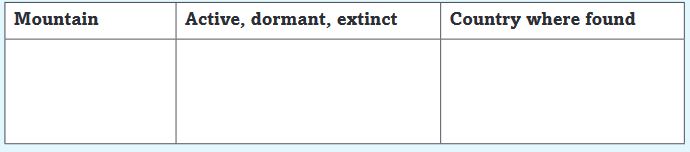
4.5.4 Types of volcanoes
Volcanic activity is going on in various parts of the world while in others it is quiet for a while. There are however, those areas where it is completely silent. In terms of volcanic activity, volcanoes are classified into three categories namely, active, dormant and extinct.
Activity 4.20
1. In groups of three, describe each of the following terms in reference to volcanoes:
a) Active volcano
b) Dormant volcano
c) Extinct volcano
2. The following are examples of the various types of volcanoes found in East Africa.
• Nyamuragira • Nyiragongo
• Bisoke • Karisimbi
• Muhabura • Gahinga
• Kilimanjaro
• Ngorongoro
• Mt Kenya
Copy and complete the following table. Ensure you classify each mountain mentioned above in the table below.
4.5.5 Effects of vulcanicity
The process of vulcanicity and the resultant features have a significant effect on both the physical and human environment. The effect may be positive or negative.
Activity 4.21
The following are the effects of vulcanicity.In groups of five, classify each point as a positive effect or a negative effect. Give reasons for your answers. Present the findings to the class.
(a) Many types of volcanic lava, upon weathering, form fertile soils which are of agricultural value and in which a variety of crops may grow. This is of economic importance to the people.
(b) Geysers are harnessed to produce geothermal electricity. Geothermal sites in Rwanda are found in areas such as Rubavu, Kinigi and Karisimbi. The sites are found in the western region of the country in Rubavu District near Lake Kivu
(c) The variety of volcanic features formed attract tourists who in turn bring into a country, the much needed foreign exchange that can be used for further development.
(d) Many volcanic mountains receive relief rainfall on their windward slopes. They become water catchment areas and a source of rivers. The waters of these rivers can be used to generate electricity, for irrigation in the lower lands and for domestic and industrial use. Agriculture and forestry can thrive on the wet slopes too.
(e) Many varieties of igneous rocks are used in the construction industry for building roads, bridges and houses.
(f) A variety of hot springs and geysers are used by some people as health spa. It is believed that the water and the minerals contained therein have healing effects.
(g) When volcanic eruptions occur, they may lead to loss of life and property. Lava flow has been witnessed in areas near Lake Kivu, from the eruption of Mt. Nyamulagira. In 2002, the mountain erupted, leading to extensive damage to the city of Goma, and destruction of wildlife in the surrounding areas, reaching as far as Lake Kivu in Rwanda in Rubavu District.
(i) The presence of a number of volcanic features becomes a barrier to construction of communication lines.
4.5.6 Distribution of volcanoes
Volcanoes are mainly found in those parts of the earth’s crust which are weakened by tectonic forces and thus provide easy passage for magma to escape to the surface. These are areas that have experienced faulting like in the rift valley regions. This include areas within the Great Rift Valley whose western arm covers parts of Uganda, Rwanda, Congo, Burundi and Tanzania.
Activity 4.22
Use the map on page 49 to identify the areas in Rwanda which are most likely to be affected by volcanic eruptions. Tabulate your findings detailing the area, district, and province where this is likely to happen.
4.6 Earthquakes
An earthquake is a sudden and rapid shaking or trembling of the earth’s crust. In Greek it is called seismos.
Activity 4.23
Use your dictionary to find out the meaning of the following terms associated with earthquakes. Write short notes about each of them.
• Epicenter
• Seismic focus
• Seismometer
• Earth tremor
4.6.1 Causes of earthquakes
Most of the earthquakes are caused by tectonic forces which cause vibrations or shocks within the earth’s crust. These shocks are then transmitted from the point of origin outwards. This point is known as the seismic focus,hypocenter or the origin. This is inside the earth. The position on the surface of the earth that is vertically above the seismic focus is called the epicenter. Many earthquakes are violent but those that are least violent are known as earth tremors.
Activity 4.24
Earthquakes are caused by natural reasons such as tectonic movements orvulcanicity. However, in some cases, they result from human activities.
In groups of four:
1. Explain how tectonic movements and vulcanicity may cause an earthquake.
2. Discuss some of the human activities that may cause earthquakes.
Apart from tectonic movements, vulcanicity and human activities, the following are other causes of earthquakes:
1. Gravitative pressure: The force of gravity acts on the rocks of the earth’s crust lying over the empty chambers left when magma escapes to the surface. The rocks collapse inwards and this causes the ground to shake.
2. Isostatic adjustment: Some parts of the earth’s crust lose materials while others gain as the materials are added onto the surface causing it to sink. Beneath the crust, materials may also move away into other regions where they push the crust upwards. The up and down movements of the crust can trigger tremors in the earth.
3. Excessive energy release within the mantle: Radioactivity within certain parts of the mantle may result in excessive release of energy in an explosive manner. This can set off shock waves that translate into earthquakes.
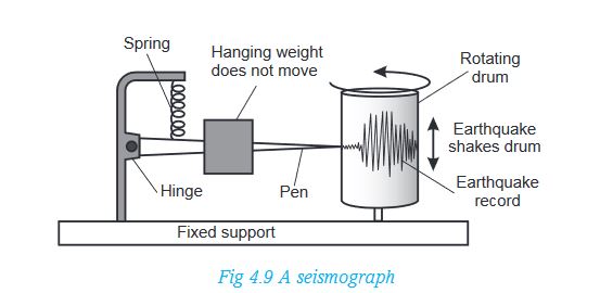
4.6.2 Measurement of earthquakes
A seismograph is the instrument used to measure earthquake shocks in form of waves. It has a delicate instrument that receives the impulses of the shocks. This is called a seismometer. These impulses are at the same time recorded on a chart that looks like a graph and attached to a drum. This chart is called a seismogram. It is on this seismogram that the reading and interpretation of seismic waves is made.
The strength of an earthquake is measured using either its intensity or its magnitude.
Activity 4.25
The intensity and magnitude of an earthquake are measured by different scales.
1. In pairs, find out the difference between:
• The intensity of an earthquake
• The magnitude of an earthquake
2. Identify an instrument used to measure:
• The intensity of an earthquake
• The magnitude of an earthquake
4.6.3 Consequences of earthquakes
Activity 4.26
1.When earthquakes occur, they have always been thought to cause negative effects. Find out any positive effects earthquakes may have.
2.In groups of five, study the following photographs showing the effects of earthquakes. Write down brief notes on what you see.
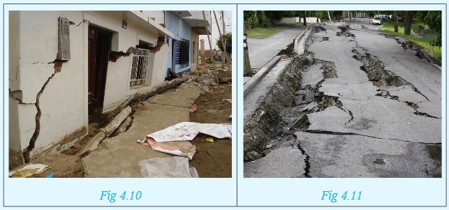
The effects of earthquakes vary depending on the magnitude of the earthquake in question. Some can be disastrous while other are mild. The following are some of them.
(a) The effect of earthquakes in densely populated areas can be disastrous. Loss of human life and destruction of property are common effects of earthquakes.
(b) Some powerful earthquakes cause development of violent motions in the earth making the surface look like a series of waves.
(c) Violent earthquakes can set off the processes of folding, faulting and even vulcanicity. It should be noted however, that these processes also cause earthquakes.
(d) When a massive earthquake occurs on the sea bed, it rocks the sea floor resulting in development of a very unusually powerful wave called a tsunami. These are common in Japan and surrounding ocean.
(e) Earthquakes are known to cause vertical or lateral displacement of parts of the land. Parts of the sea floor can be raised or lowered as well.
(f) Landslides are common effects after occurrence of strong earthquakes on steep areas.
4.6.4 Major regions of earthquakes
The regions where earthquakes occur frequently are referred to as seismic zones. These are associated with areas of crustal weakness such as faulted and folded areas and volcanic regions. The major regions include:
(i) The region across Western Province in Rusizi, Nyamasheke and Rubavu.
(ii) All regions along the boundaries of the earth’s tectonic plates.
(iii) The regions of the earth’s rift valleys, where the blocks of land periodically slide against each other along the fault planes as the earth tends to settle.
END OF UNIT REVISION QUESTIONS
In groups:
1. State the causes of earth movements.
2. Using diagrams, explain the formation of normal faults and reverse faults.
3. List examples of fold mountains in Africa.
4. Mention areas of warping in Rwanda.
5. Using geographical knowledge, explain the effects of earthquakes.