General
- P5: Social Studies File Uploaded 31/07/22, 11:23
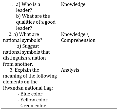
UNIT 1:Our province and its location in Rwanda
Key Unit Competence: Describe the province
Attitudes and Values: Develop a culture of using a map to locate places.
In primary four, we learnt about our districts. Districts are grouped into large administrative units called Provinces.
1.1 Our provinces and their locations
A province is a large administrative unit made up of many districts.
In Kinyarwanda a province is called Intara and a district is called Akarere.
Rwanda is made up of five provinces. These are as follows.
• The Eastern Province • The Western Province
• The Northern Province • The Southern Province
• Kigali City/Central ProvinceThe map below shows the administrative provinces of Rwanda
Activity 1.1 Map of Rwanda showing its five provinces
Discuss the following questions:
1. How many provinces are there in Rwanda?
2. Name the biggest province in Rwanda.
3. In which province is your school located?
4. Draw a map of Rwanda in your exercise book and show the five provinces.
5. What is the name of your province?6. Locate your district on the map given on page 5.
Provinces are made up of different districts as shown in the table below:
Activity 1.2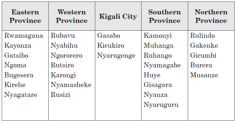
Discuss the following questions:
1. How many districts are there in the
a) Northern Province
b) Southern Province
c) Eastern Province2. Which is the biggest district in the Eastern Province.
1.2 A case study of Kigali City Province
The map shown above is of Kigali City Province. It is also called Central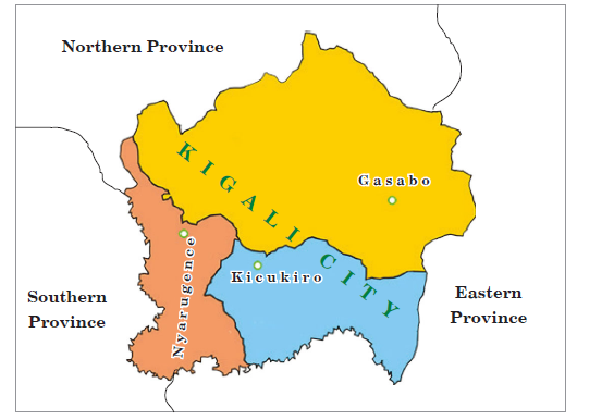 Map of Kigali City and its neighbouring provinces
Province because it is located in the centre of Rwanda.
Location of provinces neighbouring Kigali City
The Provinces have borders with other provinces. The provinces next to them are their neighbours.
Look at the map of Kigali City and the provinces on its left, right, top and bottom. They are all neighbouring provinces of Kigali Province. The topmost part is the north, right side is the east, left side is the west and at the bottom is the south. Therefore, the Northern Province, the Eastern Province and Southern Province are the neighbouring provinces of Kigali City Province. The Northern Province lies in the north, the Eastern Province lies in the south and east directions and the Southern Province lies in the west of Kigali City.Children locating different provinces on the map of Rwanda
Activity 1.3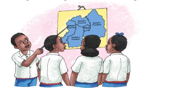
Using the map answer the following;
1. Name the provinces that neighbour Kigali City.
2. Which province of Rwanda is not a neighbour of Kigali City?
3. Using the map of Rwanda, draw the map of your province.
4. What are the neighbouring provinces of your province?
Districts of Kigali City Province
The Kigali City Province has three districts, namely, Gasabo, Kicukiro and Nyarugenge. Gasabo is the largest district and Nyarugenge is the smallest district.
Activity 1.4
1. How many districts does your province have?
2. In which direction of Kigali City is the Eastern Province located?3. Which is the smallest district of Kigali Province?
1.3 Elements of a map and its importance
What is a map?
A map is a diagrammatic representation of an area of land showing features like roads, cities, mountains, etc.
Elements of a good map
A good map should have the following elements or content:
• Frame / Border
• Title / Heading
• Key/ Legend
• Scale
• Compass direction/Compass rose
Look at the map given below. Do you find all the elements mentioned above in the map?
Importance of the elements in a map
Each of the elements on a map are important for map readers in
the following ways:
Frame: Encloses a map.
Heading: Tells us what the map is about.
Legend: Is used to interpret symbols on a map.
Scale: Is used to show or calculate the actual distance between places on a map in relation to the ground.
Compass direction
A figure on a map displaying directions and their intermediate points.
A compass is also an element of a map used to show direction of places on a map.
A Compass rose has four major points called cardinal points:
• North
• South
• East• West
These four directions are also known as the cardinal directions.
Compass: An instrument used to find directions. It has a needle that always points to the north. It is used by pilots, tourists, mountain climbers, soldiers, travellers and sailors.
Long ago, people used to tell the direction of places with the help of the sun, road junctions and landmarks like mountains, hills, lakes and valleys.
The major point on a compass is North and the compass needle always points in a northerly direction when at rest. Once North is known, we can find out the remaining directions.
The points between the cardinal points are called Secondary Points or
Semi cardinal Points. These are:
• North East (NE)
• South East (SE)
• South West (SW)• North West (NW)
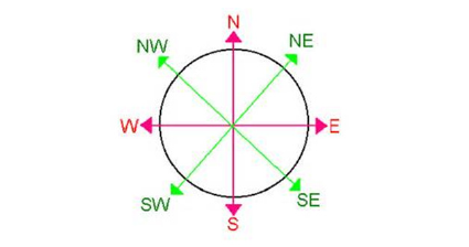
Diagram showing the secondary compass points
Activity 1.5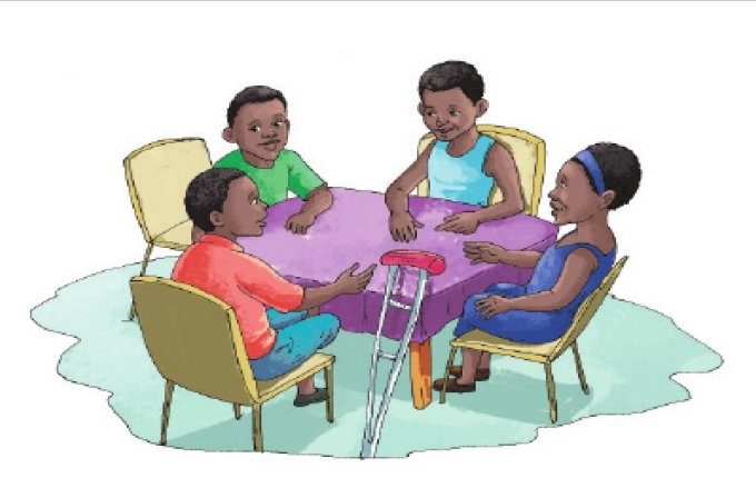
Discuss the following questions
1. How many pupils are discussing in the picture above?
2. In which direction is the boy wearing a red shirt seated?
4. Give another name for the ‘secondary points’ of a compass.
5. Draw and label the four secondary points of a compass.
6. Apart from sailors, name three other groups of people who need a compass to do their work.
7. Which direction is opposite to North East (NE)?8. What is the use of compass directions on a map?
Revision Exercise
1. Define a province?
2. A province in Kinyarwanda is called .....................
3. Name three provinces that neighbour Kigali City.
4. In which province of Rwanda do we find Lake Kivu?
5. Name the smallest and the biggest province of Rwanda.
6. Match the following provinces with their district.
Province Main district
a) East i) Karongi
b) South ii) Kigali
c) West iii) Rwamagana
d) North iv) Nyanza
e) Central v) Musanze
7. Which one is bigger, a province or a district?
8. Give the two provinces which share their borders with Burundi.
9. How many provinces are there in Rwanda?
10. What is a map?
11. Identify three elements of a good map.
12. How can a map reader interpret map symbols?
13. Why is a scale needed on a map?
14. Differenciate a compass from a compass direction?
15. Apart from using a compass, how else can one tell the direction of a place?
16. Draw a diagram showing the compass directions, indicate the cardinal points only.
17. Draw a diagram only indicating the cardinal compass directions.
18. In which direction does the;
a) sun rise?..........................
b) sun set?...........................
19. If a girl is walking in the morning and her shadow is in front of her, which direction is she walking in?
20. Rwanda is made up of ………… provinces,......... districts and ……………administrative sectors.
21. Which of these provinces does not share boarders with Rwandans neighbours?
a) Eastern province.
b) Western province
c) Kigali cityd) Southern province
- SST P5 SB File Uploaded 21/12/20, 17:18
- SST P5 TG File Uploaded 21/12/20, 17:20
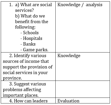
Unit 1

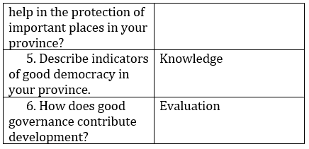
Unit 2

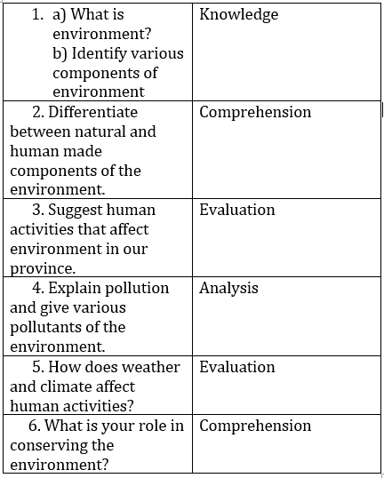
Unit 3
Unit 4
Unit 5
Unit 6
Unit 7
Unit 8
Unit 9
Unit 10

- OTHER QUESTIONS File Uploaded 26/04/20, 12:42