General
- Social Studies for ECLPE Y2 SB File Uploaded 2/11/21, 14:01
UNIT 1 INTERNAL LANDFORM PROCESSES
By the end of this unit, the student-teacher should be able to examine theinternal processes responsible for the evolution of different relief landforms.
Landforms are natural features on the surface of the earth that change over
time due to endogenic (internal) and exogenic (external) processes.
Endogenic processes occur as a result of internal forces within the earth
especially due to heat and pressure. They lead to the occurrence of faulting,
folding and vulcanicity that result into the formation of different landforms.
These landforms are later modified by exogenic processes like weatheringand mass wasting to form other landforms on the surface of the earth.
1.1. Faulting
1.1.1. Meaning of faulting
Faulting is an endogenic process whereby the rocks of the crust are fractured and
displaced. This is caused by intense heat and pressure that accumulate within
the earth interior leading to formation of compression and tensional forces.
These forces may displace the bed rock for a few centimeters or hundreds of
kilometers.
1.1.2. Types of faults
Faults are categorized based on the relative movement between the blocks
on both sides of the fault plane. This movement can be vertical, horizontal or
oblique.
1. Normal faults occur when tensional forces act in opposite directions
and cause one slab of the rock to be displaced up and the other slab
down. The tensional forces pull the earth’s crust apart from the centralpoint.
2. Reverse faults are created when the rock above the fault plane (hanging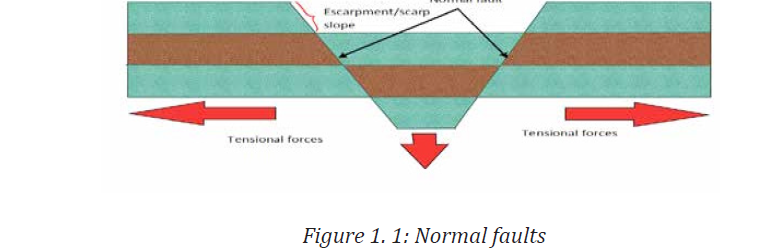
block) moves up relative to the rock below the fault plane. This is causedby compression forces
3. Strike or tear fault. These are formed when rocks on either side of the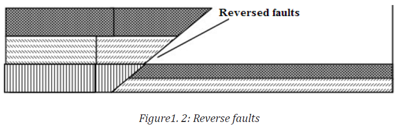
fracture slip past each other. These types of faults produce horizontal
displacements. They are usually found along boundaries that are slidingpast each other.
1.1.3. Landforms associated with faulting
Faulting has a significant effect on landscape. It has led to the formation of
various landforms as explained below.
1. Block mountains
A block mountain is also referred to as a horst mountain. It refers to the upland
bordered by faults on two or more sides. A block mountain is formed when a
fault block, bounded by normal faults is uplifted high enough to become a faultblock
mountain. Examples of Block Mountains include;Mt.Rwenzori in Uganda, Usambara in Tanzania
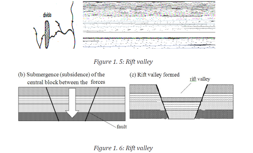
2. Rift valley
A rift valley is an elongated depression bounded by fault scarps on either sides.
It is characterized by a flat floor and steep slopes called escarpments. There
are three theories responsible for the formation of a rift valley. They include;Tensional, compressional and differential movement theories.
According to tensional theory, cracks develop and ultimately the central block
subsides, leaving the side blocks hanging with steep sides. The cracks are
caused by tensional forces that drag the crustal rocks in different directions.The best example of a rift is the great East African rift valley
3. Grabens or fault basins
These are depressions that are formed on the rift valley floor due to secondary
faulting. They are later filled with water to form fault or rift valley lakes. These
lakes vary in size, depth and salinity. They tend to be relatively small and deep.
Good examples of rift valley lakes include; Lake Tanganyika, Kivu, Edward,Albert, Baringo and Turkana in East Africa.
4. Fault guided valleys
These are valleys or depressions located along a single fault. Tear or strike
faulting causes horizontal movement and shattering of rocks along the line of
movement. This means that such rocks are easily eroded. Rivers flowing across
such a region take advantage of the weak rocks and erode them hence forming
fault guided river valleys.Examples are River Aswa in Uganda and Kerio in Kenya
Fault scarps
A fault scarp is a steep slope which develops when the earth’s crust is subjected
to faulting. When one slab slips down relative to the other. These scarps
are later subjected to denudation processes. Examples include; Butiaba inUganda,Chunya and Manyara in Tanzania,Mau and Nandi in Kenya.
1.1.4. The impact of faulting on human activities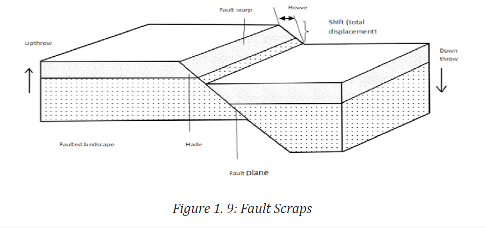
• Faulting has led to creation of attractive scenery which attracts tourists.
These attractions range from Block Mountains, rift valley lakes,
escarpments and many others. These tourist bring foreign exchange
which is important to stimulate economic development.
• Faults have also led to the formation of waterfalls and rapids. These
form potential sites for Hydropower generation that is instrumental
for industrial development.
• Faulting resulted into the formation of rift valley lakes like Tanganyika,
Edward, Kivu etc. These act as fishing grounds that provide fish rich in
proteins. Besides, these lakes help in climate modification around the
area where they are found.
• Rift valley floor is extensively flat. This facilitates a number of land use
activities like settlement and mechanized agriculture. This common
around Towns like Nakuru, Naivasha, and Kasese.It has also promoted
urbanization of Gisenyi in Rwanda.
• Faulting has also promoted mining as some rift valley lakes contain
minerals like salt like Magadi and Katwe. There are also huge deposits
of soda ash in Lake Magadi in Kenya. The presence of these mineral
deposits has stimulated industrial activities in these areas.
1.1.5. Main fault areas
Fault areas are mainly located in the following regions of the world:
• East Africa: Faulted areas in East Africa extend from Mozambique in the
South to the Red Sea in the North and from Malawi through Tanzania
and Burundi, then Rwanda to Uganda and Kenya.
• Western Europe: Many faulted areas are in deep oceanic parts of the
Atlantic Ocean in Western Europe.
• The Rhine Rift Valley extends along the border of North East France
and South West Germany.
• The Western Coast of North America, which includes the San Andreas
Fault of California.
• The Alpine fault region in New Zealand in the Far East
• The North Western highlands of Scotland and the Guadalquir valley ofSpa.
1.2.1. Folding
When a body of rock, especially sedimentary rock, is squeezed from the sides
by tectonic forces, it is likely to fracture and/or become faulted if it is cold and
brittle, or become folded if it is warm enough to behave in a plastic manner.
The nomenclature and geometry of folds are summarized on the diagram
below. An upward fold is called an anticline, while a downward fold is called
a syncline. In many areas it’s common to find a series of anticlines and synclines,
although some sequences of rocks are folded into a single anticline or syncline. A
plane drawn through the crest of a fold in a series of beds is called the axial
plane of the fold. The sloping beds on either side of an axial plane are limbs. An
anticline or syncline is described as symmetrical if the angles between each of
limb and the axial plane are generally similar, and asymmetrical if they are
not. If the axial plane is sufficiently tilted that the beds on one side have beentilted past vertical, the fold is known as an overturned anticline or syncline.
1.2.2. Types of folds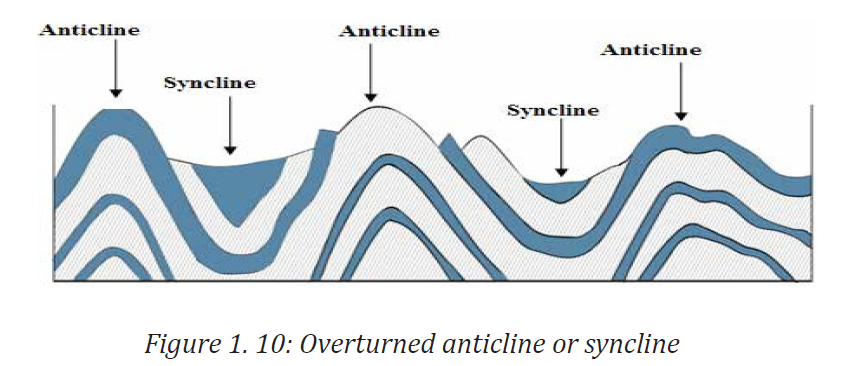
Folds appear in different shapes and sizes. Some are large and others are small.
There are many types of folds. They are characterized according to their shape
and angle.
Symmetrical folds
If the axial plane along which a fold occurs is vertical, the resulting fold is a
symmetrical fold. The crests of the fold are called anticlines and the troughs arecalled synclines.
Asymmetrical folds
This is a type of fold where one side is steeper than the other and tilted. It is
called asymmetrical because the force causing the bend was stronger one sidethan the other.
Overfold or overturn fold forms where there is intense compression and
the limbs dip in the same direction. Compression forces cause upper part tooverride the lower part.
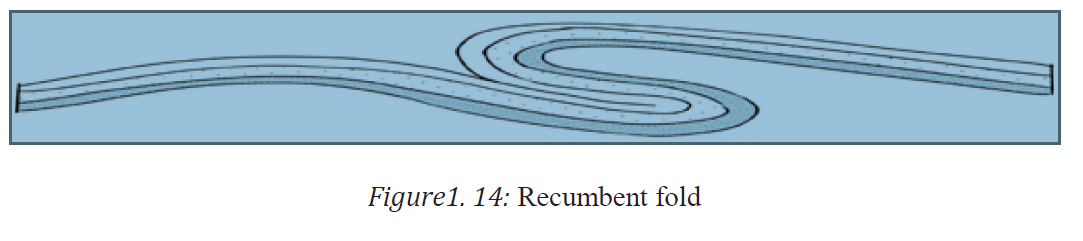
Recumbent fold. This is associated with very high degree of folding. The layers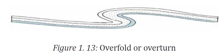
are overturned to the extent that the limbs are horizontal.
1.2.3. Warping:

1.2.3.1. Definition, types and causes of warping.
Warping involves a gentle deformation of the crust affecting a considerable
area. This is caused by sinking conventional currents which pull the earth’s
crust towards the core leading to a saucer shaped depression in the center.
There are two types of warping namely; down warping and upwarping.
i. Down warping occurs where the sinking currents drag down part of the
lower crust. Therefore, the crustal layers bend inwardly to form a basin. This
created East African major basins of Victoria, Kyoga and Muhazi in Rwanda.
ii. Upwarping: during down warping, the outer part of the crust layers tends to
move upwards. This is commonly caused by isostatic movements associated
with upward movement. It produced the upland regions and other uplandselsewhere in the world
When an area is affected by both down warping and up warping, the combined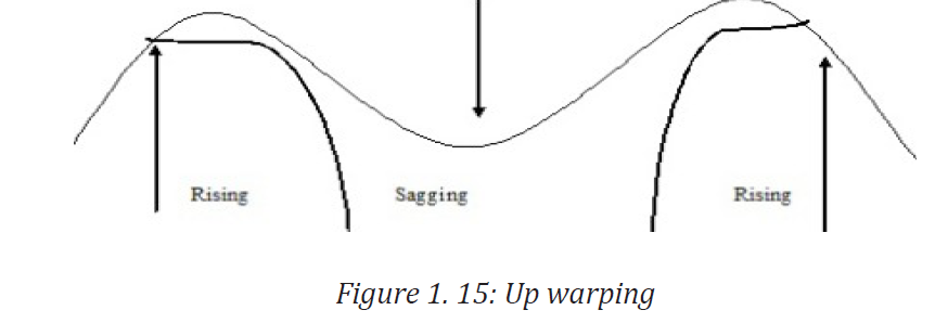
effect is called Broad warping.
1.2.3.2. Landforms associated with warping.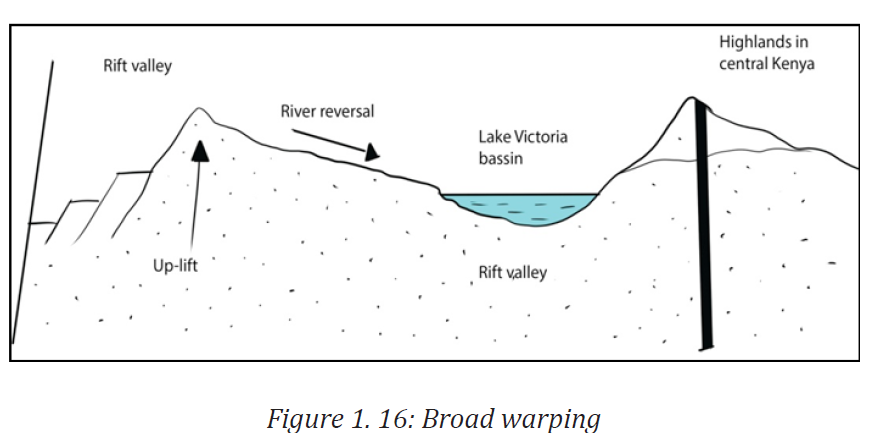
The process of warping led to the formation of the following landforms
Plateaus. This is an extensive upland part of the earth crust which is almost
flat at the top. Most areas in Rwanda were affected warping. Other examples ofplateaus include Jos plateau, Guinea highlands and Ahagger.
Bain. A basin is a large and extensive depression on the surface of the earth. Itis formed due vertical downward movement of the earth crust.
Examples of basins include inland basins like Congo, Chad and Amazon basins.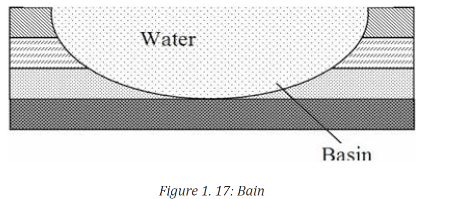
When a basin is filled by water, it forms lakes like Lake Victoria, Kioga in Uganda,
Muhazi and Mugesera in Rwanda.
Plains are extensive areas of generally flat relief. They are normally found onthe coastlines where warping greatly affected these areas.
1.3. Vulcanicity
1.3.1. Definition of vulcanicity
Vulcanicity is one of the processes that are indirectly linked with faulting. When
the earth’s crust develops a line of weakness, the already mobile and molten
rocks under intense pressure from overlying rocks will overflow through this
line of weakness (fault) and move upwards from the mantle into the earth
crust. The process of movement of this magma from the deeper layers of the
crust into or on top of the crust is referred to as vulcanicity. If this magma cools
inside the bedding planes it leads to formation of intrusive volcanic features.
vulcanic features or volcanic features. Vulcanicity therefore refers to the processthrough which intrusive and extrusive features are formed.t
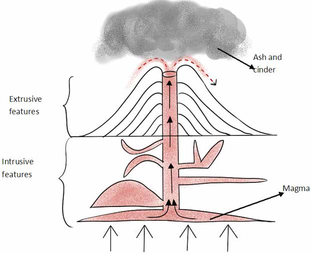
Figure 1. 18: Vulcanicity: intrusive and extrusive features
1.3.2. Extrusive volcanic features
Extrusive volcanic features are landforms of vulcanicity that are formed when
magma reaches the earth surface. There are various landforms resulting from
extrusive volcanic:
1. Volcanoes: volcanoes are conical or dome shaped features built when
magma escapes through the vent or fissure on to the earth surface. The
magma rises in a vent from a reservoir of magma from the mantle. These
materials accumulate around the vent and repeated eruptions and
accumulations lead to the building up of volcanoes. The size and shape
depends on the nature of materials erupted and the mode of eruption.
Therefore, there are different types of volcanoes ranging from small
conical hills to vast mountains.
Types of volcanoes
i. Composite cone or strato volcanoes
Composite volcanoes, sometimes called stratovolcanoes, are typically deepsided,
symmetrical cones of large dimension built of alternating layers of lava
flows, volcanic ash, cinders, blocks, and bombs and may rise as much as 8,000
ft above their bases.
Most composite volcanoes have a crater at the summit that contains a central
vent or a clustered group of vents. Lavas either flow through breaks in the
crater wall or from fissures on the sides of the cone. Lava, solidified within the
fissures, forms dikes that act as ribs which greatly strengthen the cone.
The essential feature of a composite volcano is a conduit system through which
magma from a reservoir deep in Earth’s crust rises to the surface. The volcano
is built up by the accumulation of material erupted through the conduit and
increases in size as lava, cinders, and ash are added to its slopes. Examples of
composite cones include Kilimanjaro in Tanzania, Birunga in Northern Rwanda,Longonot in Kenya and many others.
ii. Ash and cinder cones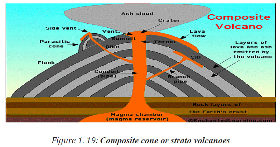
A cinder cone is a steep conical hill of loose pyroclastic fragments, such as
either volcanic ash, or cinder that has been built around a volcanic vent. The
pyroclastic fragments are formed by explosive eruptions or lava fountains from
a single, typically cylindrical, vent. As the gas-charged lava is blown violently
into the air, it breaks into small fragments that solidify and fall as either cinders,
or scoria around the vent to form a cone that often is symmetrical; with slopes
between 30–40°; and a nearly circular ground plan. Most cinder cones have abowl-shaped crater at the summit.
iii. Basic lava cones or shield volcanoes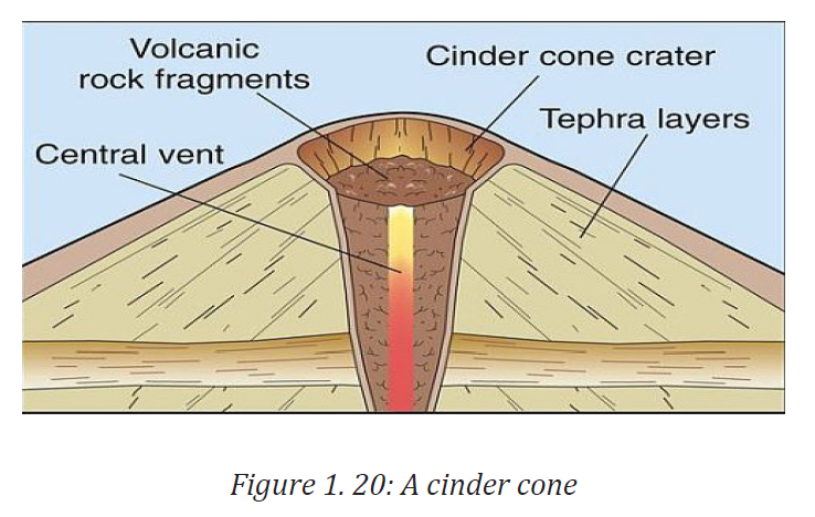
These are also called basalt domes. Shield volcanoes derive their name from
their distinctive, gently sloping convex slopes that resemble fighting shields.
They are formed from basic lava which is very fluid and mobile. It is therefore
able to flow a long distance before solidifying. They are formed from several
fluid basaltic lava flows that erupt non-explosively. Such flows can easily spread
for a long distance from feeding volcanic vents. The volcanoes formed are very
low in height with gentle slopes. Examples include Mt. Marsabit and Tukuyu inTanzania.
1. Volcanic plug or neck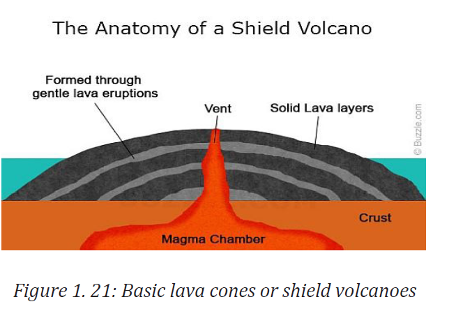
A volcanic plug is a hill resulting from differential weathering and erosion
between the former feeder tube of a volcano and its surrounding rocks.
A volcanic plug, also called a volcanic neck or lava neck, is a volcanic landform
created when lava hardens within a vent on an active volcano. When forming,
a plug can cause an extreme build-up of pressure if volatile-charged magma
is trapped beneath it, and this can sometimes lead to an explosive eruption.
If a plug is preserved, erosion may remove the surrounding rock while the
erosion-resistant plug remains, producing a distinctive landform. Examples are
in Tororo, Uganda, Alekilek on Mt. Napk, Batian and Nelion on Mt. Kenya andMawenzi on Mt. Kilimanjaro.
2. Crater: This is a volcanic depression on top of the volcano. There can be
a ring
crater or explosive crater in circular shape when a crater is filled by water, it
forms a Crater Lake. Examples of crater lakes in Rwanda are found on Kalisimbi,Muhabura and Bisoke volcanoes.
3. A caldera: This is a wide depression that usually forms on top of a
volcanic mountain due to explosive secondary eruption. When a caldera
is filled with water, a Caldera Lake is formed. A typical example of drycaldera is Ngorongoro Caldera in Tanzania
1.3.3. Intrusive feature
Intrusive landforms are formed when magma cools within the crust. The
intrusive activity of volcanoes gives rise to various forms. These features occur
beneath the crust and may be exposed to the surface after the overlying rock is
removed by erosion. They include the phaccoliths, laccoliths, volcanoes, dyke,lapoliths and sills.
1. Batholiths. These are large rock masses formed due to cooling down and
solidification of hot magma inside the earth. They appear on the surface
only after the denudation process remove the overlying materials.
Batholiths form the core of huge mountains and may be exposed onsurface after erosion. These are granitic rocks.
2. Laccoliths. These are large dome-shaped intrusive bodies connected by
a pipe-like conduit from below. These are basically intrusive counterpartsof an exposed domelike batholith.
3. Lapoliths. When the lava moves upwards, a portion of the same may
tend to move in a horizontal direction wherever it finds a weak plane. It
may get rested in different forms. In case it develops into a saucer shape,concave to the sky body, it is called Lapoliths.
4. Phaccoliths: A wavy mass of intrusive rocks, at times, is found at the
base of synclines or at the top of anticline in folded igneous country. Such
wavy materials have a definite conduit to source beneath in the form
of magma chambers (subsequently developed as batholiths). These arecalled the Phaccoliths.
5. Sills. These are solidified horizontal lava layers inside the earth. The
near horizontal bodies of the intrusive igneous rocks are called sill or
sheet, depending on the thickness of the material. The thinner ones arecalled sheets while the thick horizontal deposits are called sills.
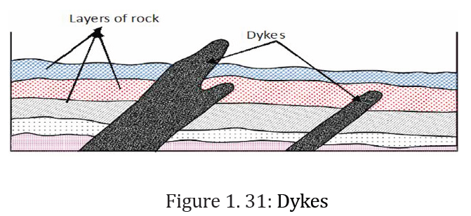
6. Dykes. When the lava makes its way through cracks and the fissures
developed in the land, it solidifies almost perpendicular to the ground.
It gets cooled in the same position to develop a wall-like structure. Suchstructures are called dykes.