Topic outline
UNIT 1 CROSS SECTIONS AND SKETCH MAPS
UNIT 1: CROSS SECTIONS AND SKETCH MAPS
Key unit competence:
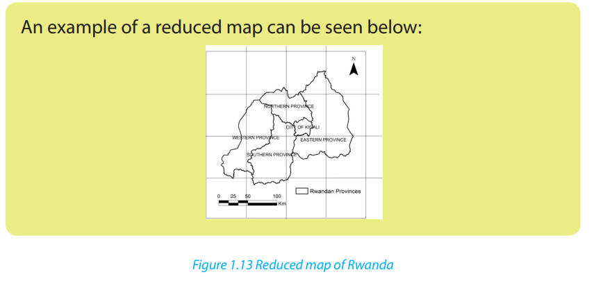
By the end of this unit, I should be able to draw cross sections and sketch maps byreduction or enlargement.Introductory activityUsing the previous knowledge and skills acquired in S4 and S.5, study the extractof the topographic map of Rwanda provided below to answer the followingquestions: 1. Use the above map to measure the distance from X to P2. Describe the relief on the map above1.1. Contour, contour interval and importance of contours
A contour is a line drawn on a map joining all the places with the same height above
sea level.
Contours cannot cross each other because each has its own fixed height and they
can be close to one another in case of steep slopes. Contours are drawn at constant
intervals known as the contour interval (CI). This is also called Vertical Interval (VI).
Contour interval is the difference in height between two adjacent contour lines.Contours are labeled from the lowest to the highest altitude as shown below.
In the study of geography, contours are important to analyze the landforms:
- They help to identify landforms like hills, plateaus, mountains and valleys on a
topographic map by analyzing the contour patterns formed by contour lines.
- Hills/mountains on a topographic map are shown as concentric rings of contours
with the highest values in the middle.
- In cases where contours are very close to each other, the relief of the area is steep.
When contours are separated by a wide space that shows a flat land.
Application activity 1.1
Use the topographic map provided below to describe contours represented onthe map and their interval.
1.2. A cross-section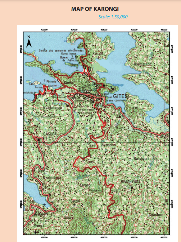
Learning activity 1.2
Use the topographic map provided below to identify flat slopes, gentle slopesand steep slopes.
A cross section is a topographical profile drawn between two points taken along a
straight line. It normally shows changes in relief of the area indicated by two points
on a topographic map.
When drawing a cross section, the following steps are followed:
• Determine the beginning and the end points of the section.
• Draw a straight line lightly in sharpened pencil from one point to another.
• Place a piece of paper with a straight edge along the pencil line.
• Mark the contour values and other important information like rivers,
settlements, roads, on the paper.
• Transfer the information on the paper to your graph paper and mark the point
on the cross section.
• Construct a frame with two vertical lines whose baseline is equivalent to the
length of the line between the two points marked on the map.
• Join all the points with a curved line following the dots on the paper to decide
the bends of the line.
An example of drawing a cross section is given on the map below. The area of study
is represented by the line between point A and point B.
To do this exercise, consider the following steps:
• Place a piece of paper on a map above along the line marked A and B
• Mark all the contours heights on the paper as shown below
The map below indicates further steps followed in recording contours on paper.
These contours indicate elevation and distances in two dimensions.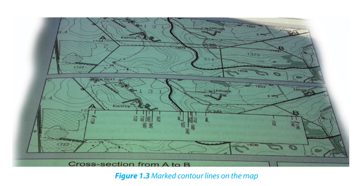
• Draw two vertical lines at each end of the horizontal line, these will represent
the Y -axes where the mark off the vertical scale will be made.
• Label point A and point B on the other end of the horizontal axis.
• Use the information on the paper to mark the highest and lowest heights
marked along the line A and B.
• Label the horizontal axis by writing the horizontal scale
• Label the vertical axis by writing the vertical scale.
• Write a title of the cross-section: cross-section from point A to point B
• Join all the dots on the graph using a free-hand line.
• Make sure the cross-section line links to points A and B on the vertical axes
1.3. Determining vertical exaggeration, the gradient, amplitude and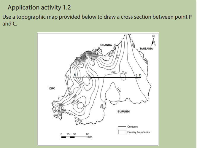
inter-visibility
Learning activity 1.3
1. Using different types of maps identify and explain different types of
scale.
2. Make research and explain the meaning of these terms: a) Vertical
exaggeration b) Gradient
1.3.1. The vertical exaggeration
The vertical exaggeration is the relationship between the vertical scale and horizontal
scale. It is calculated after drawing a cross section.
• To determine the vertical scale, refer to the scale given when asked to draw
a cross-section, e.g. 0.5 cm represents 20 m. This scale needs to be converted
into centimeter units to be used in the formula.
0.5 cm = 20 m
0.5cm = 2000cm
5cm = 20,000cm
1cm = 4000cm
Therefore, 1cm represents 4000 cm
• On topographic maps, the horizontal scale is most of time the same 1: 50,000,
i.e. 1 cm represents 50 000cm.
• As all units have been converted into centimeters, insert these measurementsinto the formula.
1.3.2. The gradient
Gradient refers to the steepness of a slope between two places expressed as a
proportion between the vertical intervals (VI) and horizontal equivalent (HE).
When two places are located at different heights (altitude), the difference in height
between them is known as the vertical rise or the vertical interval (V.I).
The horizontal distance is the distance between the two places represented on a
map which is corresponding with the real distance on the ground.
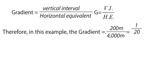
Gradient is calculated as follows:
• Plot the two points on the map which are needed to determine the gradient.
Name them for instance as A and B or X and Y.
• Join those two points by a straight line.
• Use the scale to measure the distance between A and B (H.E). Let us consider
the distance to be 8 cm.
• Calculate the actual ground distance using the map scale. If the scale of the
map is 1:50,000 meaning that 1 cm on the map represents 50,000 cm on the
ground. Therefore, the ground distance of the represented area would be 8 x
50,000 which 400,000 cm = 4000 m.
• Calculate the difference in height between points A and B, using the contours.
For example, the difference in height between A and B is 200 m.• The formula for calculating the gradient is:
1.3.3. Amplitude
Amplitude refers to the difference between the highest altitude and the lowest
altitude along the cross section.
1.3.4. Intervisibility
Intervisibility refers to whether one point on a map can be seen from another point.
• A point is intervisible when it can be seen from another point, i.e. there is no
higher land between the two points.
• A point is not intervisible when there is higher land or some obstruction that
blocks being able to see one point represented on a map from another point.
• Intervisibility can be established by drawing an intervisibility line between
two points on a cross- section.
• Intervisibility can also be established by looking at the contour heights on a
topographic map between two points to see if there are any higher areas of
land blocking the view between these two points.
• On the cross-sections in Figure 1.6 and 1.7 draw a straight line (an intervisibility
line) between the two points A and B on each sketch.
• In Figure 1.6, the intervisibility line is above the cross- section at all heights.
This means that point A is inter-visible from point B.
• In Figure 1.7, the intervisibility line is below the cross-section in one section.
This means that point A is not intervisible from point B.
When checking for intervisibility on a topographic map, join the two places with a
straight light line using a pencil or place a ruler along a line between the two points.
Check the heights all along this line to see if there is higher land blocking the viewbetween the two points.
Application activity: 1.3Use the figure below to calculate the amplitude of the area indicated
1.4. Drawing sketch maps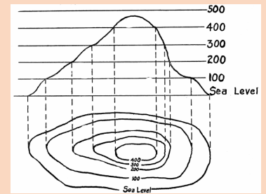
Learning activity 1.4
Move around your school and draw the site of the school compound in your
note book and explain the steps followed in drawing that sketch map.
A sketch map is a simple representation of part or whole of a sheet map drawn on
a piece of paper without using a given scale.
When drawing a sketch map, use the following procedures:
• Identify and critically observe the area to be sketched on the map given.
• Measure the edges of the map.
• Make a frame by either reducing or enlarging the map as instructed.
• Indicate both physical and human features as requested.
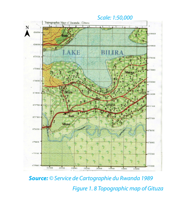
• Provide the key for the sketch map.The following are examples of a map and a drawn sketch map of Gituza respectively:
Application activity 1.4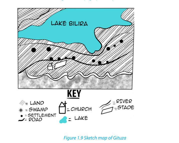
Make a field trip around your school and draw a sketch map of the nearby
market place.
1.5. Enlargement and reduction of a map
Learning activity 1.5
1. Draw a sketch map of your school, identify, mark and name the features
found there.
2. Use the same sketch map drawn in (a) above:
i. To reduce it by 2 times
ii. To enlarge it by 2 times
1.5.1. Map Enlargement
Map enlargement refers to the changing of the size of a given map to a bigger one.
It becomes bigger depending on the number of times it is enlarged. For example, it
may be decided that part of a map is enlarged, and its outline drawn.
The following steps should be followed:
• Identify an area of the original map or part of the map to be enlarged.
• Measure the length and width of the original map or identified part of the
map.
• Multiply the length and width by the number of times the map is to be
enlarged.
• Draw an outline that has new dimensions.
• Mark and label the features in their relative positions.
• The scale also changes (becomes bigger).
1.5.2. Map reduction
Map reduction refers to the changing of the size of the map to a smaller one. Below
are the steps to follow for map reduction:
• Measure the length (L) and width (W) of the given part or whole map. For
example, L=11cm and W=10.8cm.
• Divide the length and width by the number of times the given map is to be
reduced or as directed by the demands of the question. For example, by 2times.
Draw an outline that has the new length and width. For example, L=5.5cm,
W=5.4cm.
• Mark and label the features in their relative positions.
• Use a key to label features in the map.• The scale changes (becomes smaller).

i. Draw a cross section between point X and Y, make a class presentation.
ii. Enlarge two times the area on the map south of the northings 85 anddraw its outline
Unit 2: : INTERPRETATION OF PHOTOGRAPHS AND VIDEO IMAGES
Key Unit Competence:
By the end of this unit, I should be able to interpret photographs, video images and
draw sketches by reduction or enlargement of the photographs.
Introductory activity
In the previous unit, it was shown that maps are very important tools to indicate
and to describe physical and human features. Describe other ways used in
geography to show physical and human features.2.1. Definition and types of photographs
2.1.1. Definition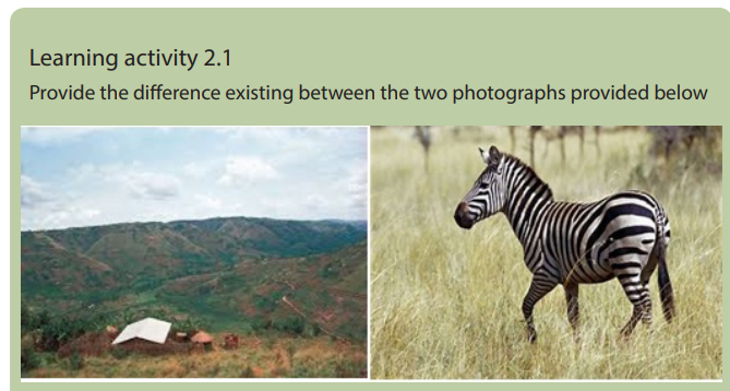
A photograph is a picture of an object or environment taken by a camera at a particular
time in a given place. Photographs are ways of recording geographical information.
They enhance the understanding of reality. However, when a photograph is taken,
some parts of the object or environment are seen while others may not be seen
clearly. A hidden ground/area which cannot be seen by a camera when a photographis taken is called a dead ground.
2.1.2. Major types of photographs
There are two major types of photographs: Terrestrial/ close or ground photographsand Aerial photographs.
Ground photographs: These are photographs taken from the ground level. They
record exactly what a person would see if he / she was standing on the ground level.
A ground photograph gives a horizontal view, great details of the landscape and
covers a small area. There are two categories of ground photographs:
i. Ground horizontal photograph: This is a photograph taken when a
camera is held horizontally to the ground.
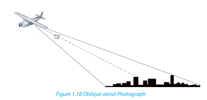
ii. Ground oblique photograph: This is a photograph taken when thecamera is titled at an angle facing the ground.

Aerial photographs: These are photographs taken from aerial station using
aircrafts, satellites, and other flying objects. They cover a wide area, features are
greatly reduced, show the top of the object, do not show the horizon. There are two
categories of aerial photographs:
i. Vertical aerial photographs: These are photographs taken when the
camera is directly above (overhead) the objects or when it is perpendicularto the ground.
ii. Oblique aerial photographs: These are photographs taken when the
camera is titled at an angle below 90 degrees.
2.2. Sections of a photograph and interpretation of physical and human
aspects
Learning activity 2.2Observe the photograph below and answer the following questions:
1. Identify the physical and human features shown on the above photograph.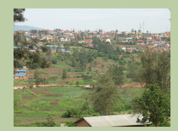
2. Indicate the respective parts where these features are found in the abovephotograph.
2.2.1. Sections of a photograph
From a horizontal perspective, photographs fall under three categories as indicated
below:
• The foreground: It is the part of the photograph located nearest to the camera.
• The middle ground: It is the central part of the photograph.
• The back ground: It is the farthest part of the photograph that includes the
horizon.
From vertical perspective, photographs are also divided in three parts: left, centerand right.
Combining both horizontal and vertical perspectives, the photographs can be put
into the following categories:
Categories of photographs depending on the position of photography
2.2.2. Interpretation of physical and human aspects on photographs and
video images
Physical and human aspects on photographs and video images can be interpreted
as follows:
a. Interpretation of physical aspects
i. Climate: Climate in a photograph is indicated by rainfall and temperature. Heavy
rainfall can be observed by presence of dense forests and crops like sugar cane,
rice and tea while high temperature may be observed by the presence of poor
vegetation, people wearing light clothes etc.
ii. Relief: The features of the relief depicted on a photograph include mountains,
hills, valleys, escarpments, plateaus and plains. A hilly or mountainous landscape
is indicated by the presence of steep slopes, presence of terraces, snow and
glaciers on the top. Plateaus and plains are identified by a uniformly flat land with
sloping edges and pools of water or irrigated land. Wide valleys with meanders
and flood plains also suggest the presence of plain land.
Relief on vertical aerial photographs can be interpreted by observing the following:
• Flat areas can be identifiable by the presence of meandering rivers, straight
roads and gentle bends.
• Plateaus can be indicated by presence of flat topped hills.
iii. Vegetation: This is the plant life that covers the earth surface; it is both natural and
artificial. When describing vegetation on a photograph, the aspects to consider
are the type of vegetation whether grassland, scrub or thicket; the tree species
such as baobab, acacia, eucalyptus; the density of the vegetation whether trees
are close together or scattered; and the nature of the vegetation whether human
made or natural.
iv. Drainage: Drainage is shown by the presence of water bodies on a photograph,
such as streams, rivers, lakes, swamps, seas, and oceans. Others are man-made
water features like wells, ponds, valley dams and boreholes. In photographs,
drainage is interpreted in the following ways:
• Rivers appear with meandering channels with swampy vegetation along them.
• Swamps appear with luxuriant vegetation dominated by papyrus reeds.
v. Soils: The types of soils can be identified by observing the types of crops grown
there because there are crops that grow well in specific types of soils, for
example, tea and coffee grow well in fertile volcanic soils. Where erosion
took place, the soils are exposed.
b. Interpretation of human aspects
Photographs and video images can be very useful in the interpretation of human
activities such as:
i. Forestry: A forest is evidenced by the presence of both artificial and
natural forests.
ii. Agriculture: Agricultural activities can be observed by the presence of
food crops and cash crops as well as animals like cattle both exotic and
traditional breeds.
iii. Transport and communication: Both transport and communication
networks are evidenced by presence of motor vehicles, bicycles, roads,
ships, airports, and communication facilities such as telephone lines and
masts.
iv. Mining: This is shown by Open pits, people undertaking mining or a
mineral processing plant show that there is mining taking place in that
area.
v. Industry: Industrialization is shown by the presence of industries emitting
smoke from huge chimneys.
vi. Trade or commerce: the commerce is evidenced by trading centers with
congested buildings and at times presence of markets.
vii. Settlement: It is evidenced by the presence of houses in differentpatterns.

2.3. Drawing sketches of photographs by reduction or enlargement
A sketch of a photograph focuses on the identification, marking using symbols and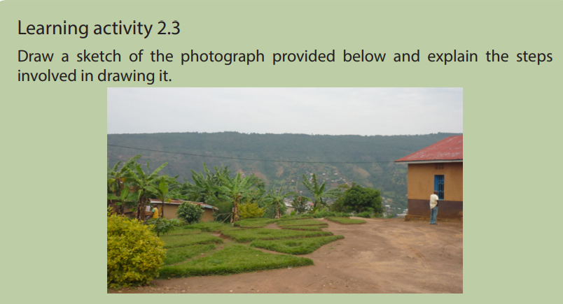
labeling marked features in their relative positions. Sketching takes into account
physical and man-made features and should reflect the proportional size of features.
To draw a sketch of a photograph by enlargement or reduction requires the following
steps:
i. Draw a rectangle and a square of the size as requested on a piece of paper.
ii. Draw horizontal lines across the photograph by using a pencil to
subdivide it into three equal sections. These will be the foreground, middle
ground and background either reduced or enlarged as instructed.
iii. Draw vertical lines across the photograph by using a pencil. These will be
left, centre and right.
iv. Place the framework of a photograph onto the prepared rectangle or
square. The framework could be the guider in placing the various features
in their respective positions.
v. Enlarge or reduce the size of features and the frame as requested.
vi. When filling in the main features, it is better to start with the background
or right by drawing the skyline as it appears on the photograph.
vii. It is better to place and label all important features either physical or
human as they appear on the photograph, reduce or enlarge them as
required.
viii. Choose a suitable title, key, orientation of a sketch. It is possible to put on
a sketch other elements of a sketch map which are useful in reading and
interpreting it.Therefore, a sketch of a photograph can be enlarged or reduced as shown below:


2.4. Relationship between physical and human aspects on photographs
and video images
Learning activity 2.4
Describe the relationship between physical and human features represented onthe photograph below.
Some photographs and video images help in showing the relationship between
human and physical aspects. The relationship between human and physical aspectis discussed basing on the photograph below:
i. Relief and transport: Transport routes occur on gentle slopes and avoid
steep slopes and valleys since it is very expensive to construct roads in hilly
areas.
ii. Relief and agriculture: On steep slopes, less agriculture takes place while
on gentle slopes most agricultural practices are observed. The low lands
are usually reserved for growing of vegetables, sugar cane, rice, and other
crops that need enough water.
iii. Relief and settlement: Settlements are commonly found in gentle slopes
and are few in steep slopes and valleys because of the problem of severe
soil erosion and flooding in valleys.
iv. Drainage patterns and settlement: Settlement occurs in well drained
areas and avoids lake shores or river banks because of floods and associated
problems.
v. Drainage and transport: Transport routes are usually found in well drained
areas. For example, roads cannot be constructed in swampy areas due to
excessive water. Water transport occurs on water bodies like rivers, lakes,
oceans and seas.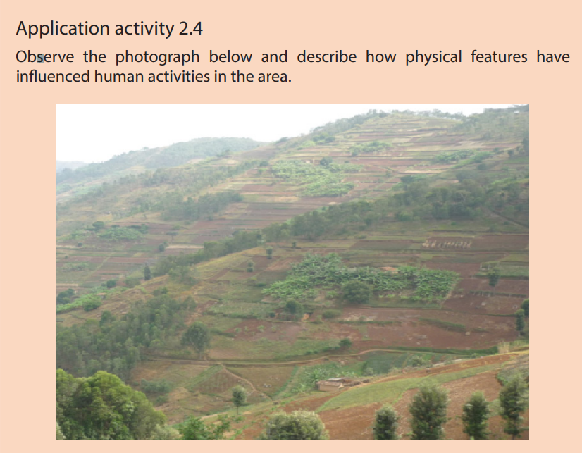
End unit assessment
1. Explain the key guidelines followed in drawing a sketch of a photograph.
2. Study the photograph provided below and answer the following
questions:
a. Identify the economic activities taking place and describe their
importance to the people living in the area.
b. Suggest ways of conserving the area in the background of the
photograph for environmental sustainability.
Unit3: THE ORIGIN AND DISTRIBUTION OF THE CONTINENTS
UNIT 3: THE ORIGIN AND DISTRIBUTION OF THE CONTINENTS
1. How many oceans do you find on map a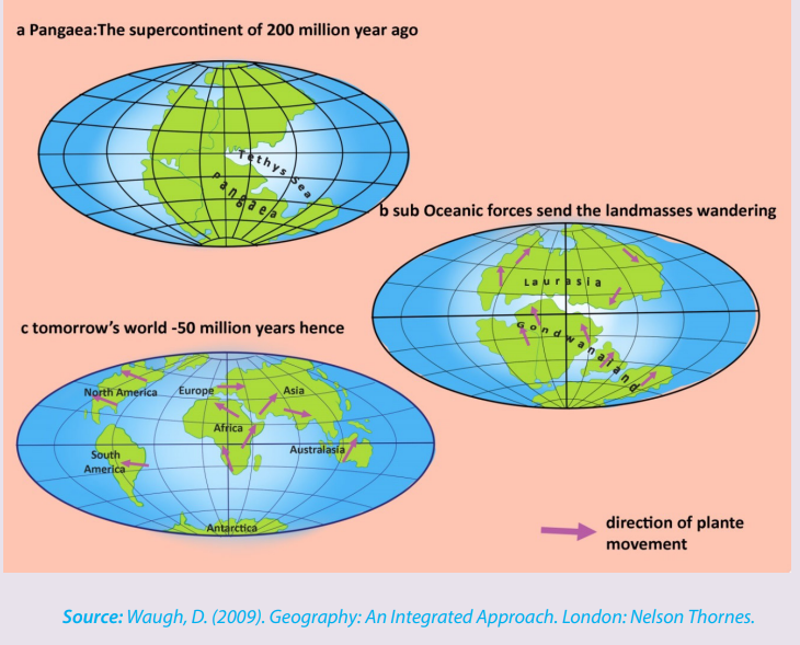
2. How many continents do you see on map b
3. How many continents do you see on map c
4. Explain the processes which led to the separation of the unique initiallandmass into various continents as they appear today.
3.1. Concept and theories of continental drift
Learning activity 3.1
Make research using books and internet to explain briefly the theories related
to the continental drift.
3.1.1. Concept of continental drift
The term continental drift refers to the study of causes and consequences of the
distribution of continents and ocean basins. It is defined as a slow movement of the
Earth’s continents towards and away from each other. The differential movement of
the outer shell resulted into fragmentation by rifting, followed by drifting apart of
individual masses of the broken outer shell.
3.1. 2. Theories of the origin and distribution of the continents and ocean
basins
There are several theories of continental drift that were developed at the beginning
of the 20th century. The following are the four main theories of continental drift:
• Alfred Lothar Wegener’s theory
• Maurice Ewing’s theory
• Harry Hammond Hess’ theory
• Frank Taylor’s theory
a. Alfred Lothar Wegener’s theory
According to Wegener’s theory, there was a breakup of the single super continent
block called Pangaea“pan JEE uh”, which means “all land” into multiple continents,
as they appear today, that moved apart in a process called continental drift. That
movement took place about 200 million years ago. The map provided below fitstogether the continents whose breaking up resulted in today’s continents.
The theory of continental drift traces the origin and distribution of continents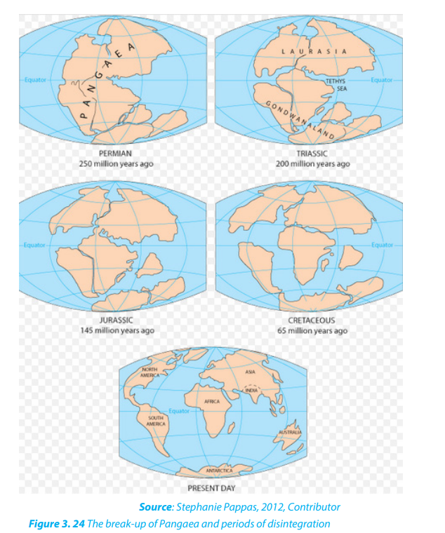
through five major steps:
i. The supercontinent Pangaea was surrounded by an extensive water mass
called the ‘Panthalassa’ (pan means all and Thalassa means oceans) or
the primeval Pacific Ocean. During the Carboniferous period (about 250
million years ago), the South Pole was near Natal (South African coast) and
the North Pole was in the Pacific Ocean.
ii. In about 200 million years, Pangaea broke up to form Laurasia (North
America, Greenland, and all of Eurasia north of Indian subcontinent),
and Gondwanaland (South America, Africa, Madagascar, India, Arabia,
Malaysia, East Indies, Australia, and Antarctica). These two blocks were
separated by a long shallow inland sea called Tethys Sea.
iii. In about 145 million years ago, the drifting of the southern landmasses
continued. India drifted northwards.
iv. In about 65 million years ago, Australia began to separate from Antarctica.
v. The present shapes and relative positions of the continents are the result
of fragmentation of Laurasia and Gondwanaland by rifting and drifting
apart of the broken landmasses following the formations of oceans and
seas (see figure 3.24). South America separated from Africa, North America
separated from Europe, while Antarctica, Australia, India and Madagascar
formed a single unit with South America.
However, Wegener’s theory was initially criticized because he could not explain how
solid continents have changed their positions. His theory has been revived by other
resev. Geodetic evidence Geodetic evidence has revealed that Greenland is drifting
westward at the rate of 20 cm per year. This is one of the scientific evidences arising
from measurement and representation of the earth that confirm the spread of the sea floor.
Application activity 3.2 1.
Describe the rocks at the edge of the continents and show how all continents
formed a unique block.
2. Using some examples, compare the fossils of animal species and
vegetation species found on different continents by showing
how they indicate the continental drift.
archers after discovering new evidences.
f. Maurice Ewing’s theory
Maurice Ewing confirmed the existence of Mid-Atlantic Ridge which is a mountain
range extending the entire length of the ocean bed which is about 1000 km wide
and rises 2500 m in height. Also, Ewing’s studies argue that rocks of this range were
volcanic and recent in origin. Similar ranges were later discovered on other oceans’
floors.
g. Harry Hammond Hess’s Theory: Sea-Floor Spreading
The Seafloor spreading theory suggests that magma from earth’s mantle rises to
the surface at mid-ocean ridges and cools to form new seafloor, which new magma
pushes away from the ridge.
The Sea-Floor Spreading theory was put forward by an American Geologist, Harry
Hess. Sea-floor spreading occurs along mid-ocean-ridge; when the tectonic plates
slowly moves away from each other, hot magma from the mantle comes up to the
surface. As magma cools by the seawater the rock forms a new part of the crust.
The interior of the Earth is in a molten (semi-fluid) state because of great heat
resulting from radioactivity within the asthenosphere. This tremendous heat causes
melting, or near-melting of rocks of the interior of the Earth. The molten rocks tend
to rise from within the mantle in form of convection currents.
Material heated by radioactive elements in the earth’s interior slowly rise in the crust.
This magma reaches the surface along the Mid-oceanic ridges and flows away fromthem, cooling and hardening to form the rigid lithosphere.
New lava emerging from the ridges attaches itself to the near solidified older lava
plates and forces them to move laterally. Hess’s studies demonstrated that after
millions of years the lithospheric plates will have moved thousands of miles by
constant additions of new lava at their rear.
The leading edges were eventually forced to sink down into the lithosphere under
the continental crust block thus forming deep ocean trenches along the edge
of continents. In this “recycling” process, later named “seafloor spreading”, older
sediments and fossils are carried off in the subduction zone, and continents are
moved as new ocean crust spreads away from the ridges.
Hess explained how the once-joined continents had separated into the seven that
exist today. The newest rocks were in the centre of the ocean, and were still being
formed in Iceland, and that the oldest rocks were those nearest to the USA and the
Caribbean. He also suggested that the Atlantic could be widening by up to 5 cm a
year. This process produced by mantle convection currents was named the “Sea floorspreading”.
h. Taylor’s theory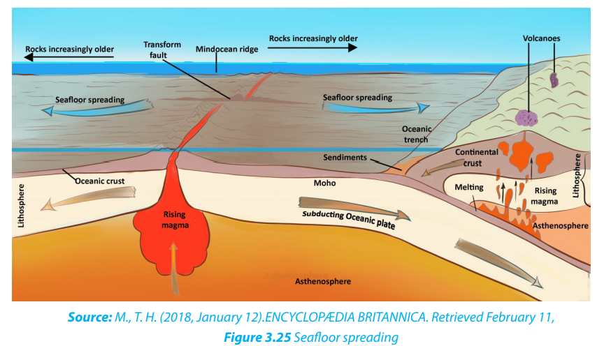
Frank Taylor’s theory states that the original Laurasia was located near the current
North Pole, whereas Gondwanaland was located near the South Pole. Both
landmasses radially moved to the Equator. Their collision would have resulted in the
formation of folded mountains, such as Atlas, Alps mountain ranges and others.
He suggested that Laurasia and Gondwanaland were forced to move from theirformer positions because of the moon’s tidal attraction. According to this theory,
the moon came very close to the earth during the cretaceous period.
This closeness of the moon to the earth exerted powerful tidal attraction, which
pulled the landmasses from their polar position towards the Equator. Where there
was resistance to the outward spread of landmasses, the crust usually would fold,
raising mountain ranges in front, while resulting in stretches (troughs and basins).
The present basins of Southern Atlantic and Indian Oceans were formed in this way.
Taylor’s arguments about continental drift have however been criticized:
• The theory doesn’t clearly demonstrate how the causes of the movement of
continents from their polar positions ought to have been from within the earth
and not outside it.
• The theory was rejected because researchers of his time doubted how the
moon could ever exert enough force to pull the huge landmasses (continents)
as they are known today.
• Finally, Taylor doesn’t explain the formation of earlier fold mountains like the
Caledonian system of Siluro-Devonian times while explaining the possible formation of the fold mountains Atlas and Alps.
3.2. Evidence of continental drift
Many evidences of continental drift exist, but they can be summarized in four major categories:
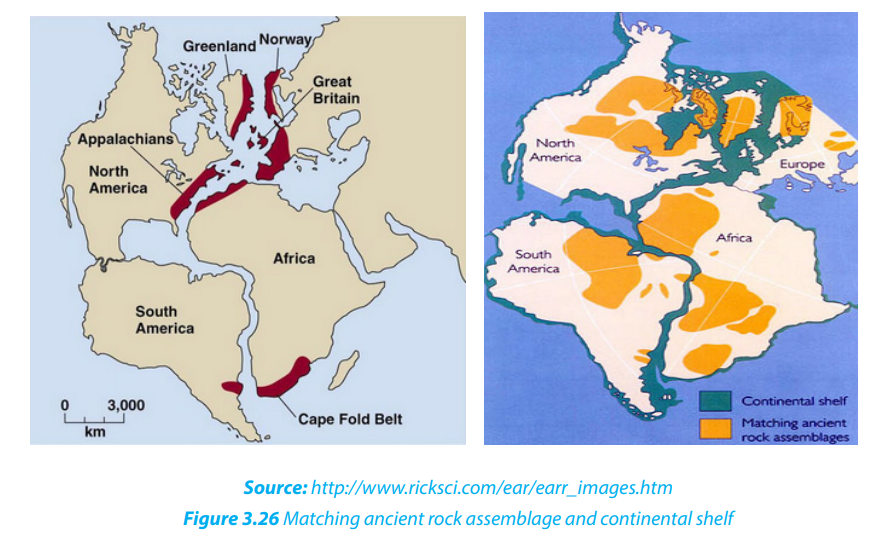
i. Geological evidence A good fit of edges of continents and
similar rock structures are found on different continents.
For example:
• East coast of South America and the Western Coast of Africa
have good visual fits, both at the surface (1000 m) and depth (2000 m).
• Both Africa and South America are composed of rocks of varying
ages and there is a convincing boundary joint across the two
continents between Accra and Sao Louis in Brazil and,
dividing Pan-African rocks and Elaurean rocks.
This evidence constitutes what is commonly known as “matching geology”
• Parts of Appalachian Mountains of the United States of America are similar
to those found in Greenland and Western Europe;
• The fact that rock particles have magnetic properties allowed geophysicists
to reconstruct the position of the poles in past times and also the probable
climatic lay belts of the past. From this, it appears that Southern Africa and
South America lay within the Arctic circle of Permian and carboniferous times
and that during the Triassic period, the continents had moved some 40° closerto the Equator.
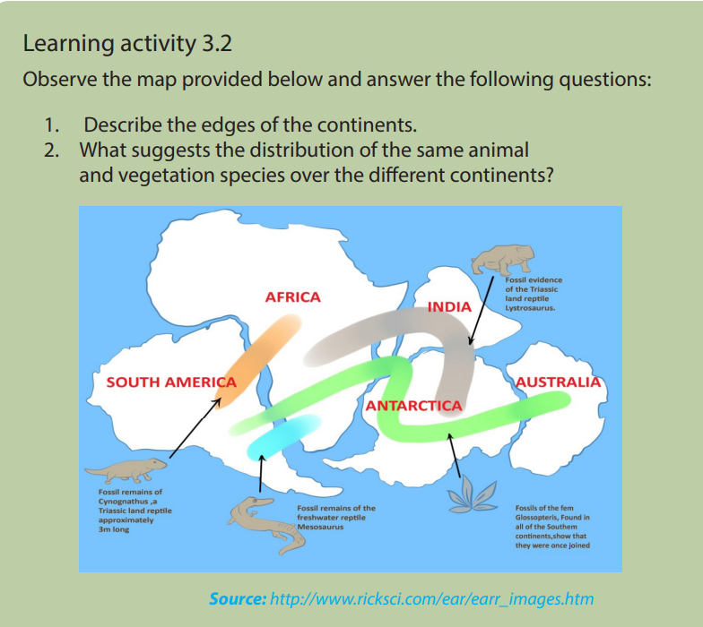
ii. Biological evidence
There is similarity in the fossils and vegetation remains found on the eastern coast of
South America and the Western coast of Africa. For example;
• Mesosaurus was small reptile living in Permian time (280 million of years before
present); its remains have been found only in South Africa and Brazil.
• Remains of Glossopteris, a plant which existed when coal was being formed
has only been located in India and Antarctica. These animals and plants could
not have swum across oceans if continents were separated by water bodies,
so continents must have been close together for them to occur on differentcontinents which probably had a similar climate.
iii. Climatic evidence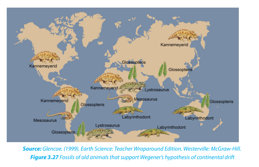
Coal formed under warm and wet conditions was found beneath the Atlantic icecap, and evidence of carboniferous glaciation had been noted in tropical and central
India. For example;
• Coal could not have been formed in Britain with its present climate.
• Peninsular India, Australia and Antarctica further prove the unification of all
landmasses in one landmass (Pangaea) during carboniferous period.
• Groves curved on rocks by glaciers in the southern parts of landmasses
forming Gondwanaland shown by arrows on the figure below provided evidencefor continental drift.
v. Geodetic evidence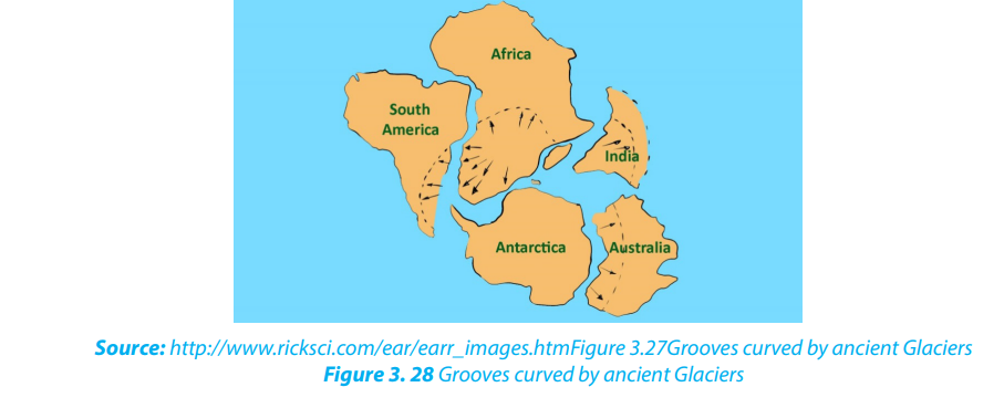
Geodetic evidence has revealed that Greenland is drifting westward at the rate of
20 cm per year. This is one of the scientific evidences arising from measurement and
representation of the earth that confirm the spread of the sea floor.
Application activity 3.2
1. Describe the rocks at the edge of the continents and show how all
continents formed a unique block.
2. Using some examples, compare the fossils of animal species and
vegetation species found on different continents by showing how they
indicate the continental drift.
3.3. Effects of continental drift on the evolution of physical features
Learning activity 3.3
Make a research and describe at least four major effects of continental drift.
The continental drift has had many effects on the evolution of physical features but
the most important are the following:
• Pangaea split apart into a southern landmass,
Gondwanaland and the northern landmass called Laurasia;
later the two super continents split again into
land masses that look like present day continents.
• Continental drift has also affected the earth’s climate. The climate of different
part of the world has changes throughout the year;
• Continental drift has affected the evolution of animals. The rearrangement
and displacement of huge landmasses has helped create the diversity which
we see present in modern day animals.
• Collision of earth crusts. The collision of the Indian subcontinent and Asian
continent created the Himalayan mountain range, home to the world’s highest mountain peaks.
• Formation of rift valleys. Rift valleys are sites where a continental landmass is
ripping itself apart. Africa, for example, will eventually split along the western
Great Rift Valley system.
• Continental drift is the major cause of earthquakes, volcanoes,
oceanic trenches, mountain range formation, and other geologic
phenomenon which created the new landscapes on the earth’s surface;
A3.4.3. Boundaries and movement of tectonic plates i. Tectonic Plate boundaries Boundaries of plate tectonic include the subduction zone, the mid-ocean ridge and the transform boundary. • Divergent boundary (Mid-ocean ridge): It is an underwater mountain range which is formed when forces within earth spread the seafloor apart. It is created when convection currents rise in the mantle beneath where two tectonic plates meet at a divergent boundary, thus forming the oceanic ridge. • Transform boundary (Transform fault): It is a boundary which exists between two plates that are sliding horizontally past one another, thus forming the transform faults (see the figure below).pplication activity 3.3
Explain the effects of continental drift on the evolution of physical landscape of
the earth.
3.4. Plate Tectonics
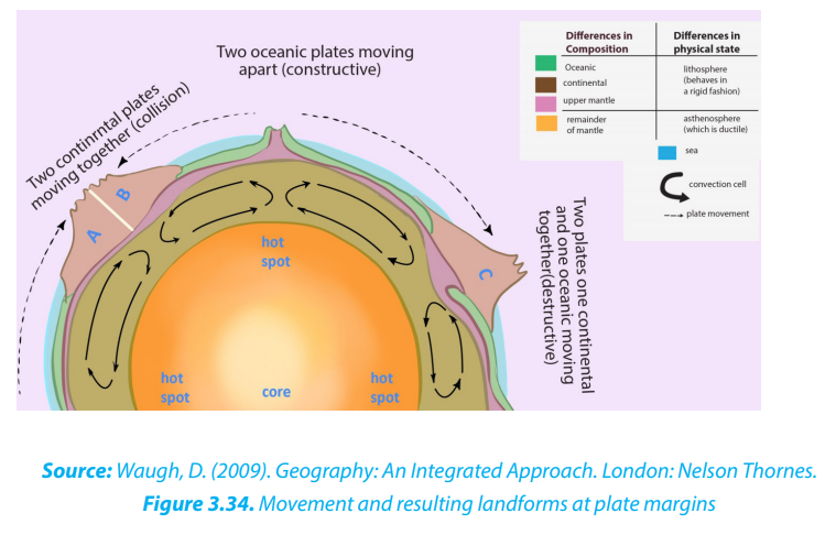
Learning activity 3.4Observe the illustration below and answer the following questions:
Source: Waugh, D. (2009). Geography: An Integrated Approach. London: Nelson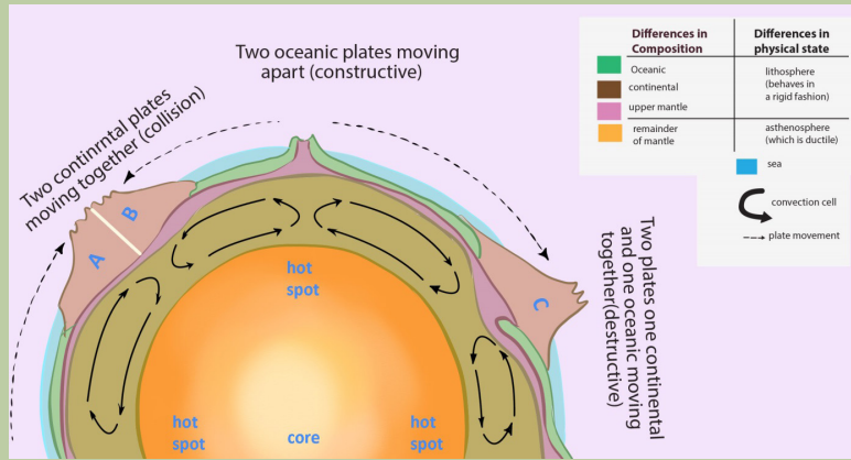
Thornes.
1. Identify the types of crust found on the map
2. Describe the difference between lithosphere and asthenosphere
3. Differentiate collision, constructive, and destructive processes
4. Determine the position of plate movements5. Explain how convection cells cause the movement of plates
The word tectonic comes from the Greek word ‘tektonikos’ meaning building
or construction; this means how the earth crust is constructed. Therefore, plate
tectonics refers to the deformation of the earth’s crust, because of internal forces,
which can form various structures in the lithosphere.
The plate size can vary greatly, from a few hundred to thousands of kilometers across.
Plates are moved by the energy originating from the earth interior. This energy
is a result of convection currents which form convection cells. Tectonic plates are
irregularly shaped slabs of solid rocks, generally presenting two types: Continentalcrust and Oceanic crust as shown on the figure below.
Tectonic processes include tension when plates diverge and compression when
plates converge. These processes result in deformation of the earth crust. Tension
causes fracturing and faulting of the crust while compression produces folds andover thrust faults.
3.4.2. Types of Plate Tectonics
There are two types of plate tectonics: continental plate and oceanic plate.
i. Continental crust is composed of older, lighter rock of granitic type: Silicon
and Aluminum (SIAL).
ii. Oceanic crust consists of much younger, denser rock of basaltic
composition: Silicon and Magnesium (SIMA). The major differences
between the two types of plates are summarized in the table below:Difference between continental plate and oceanic plate
3.4.3. Boundaries and movement of tectonic plates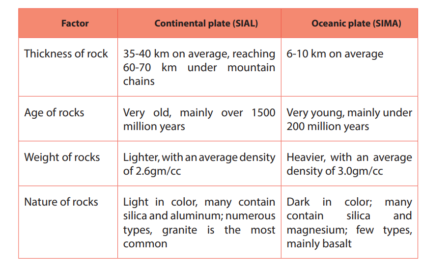
i. Tectonic Plate boundaries
Boundaries of plate tectonic include the subduction zone, the mid-ocean ridge and
the transform boundary.
• Divergent boundary (Mid-ocean ridge): It is an underwater mountain
range which is formed when forces within earth spread the seafloor apart. It
is created when convection currents rise in the mantle beneath where two
tectonic plates meet at a divergent boundary, thus forming the oceanic ridge.
• Transform boundary (Transform fault): It is a boundary which exists between
two plates that are sliding horizontally past one another, thus forming thetransform faults (see the figure below).
• Convergent boundary (Subduction zone): This is the area where an ocean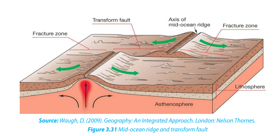
floor plate collides with a continental plate and the denser oceanic plate sinksunder the less dense continental plate, thus forming the oceanic trench.
ii. Tectonic plate movements
Plate movements include convergence, divergence and way past movementalong the transform fault.
• Convergence is a movement whereby two crustal plates are colliding or one
subsiding beneath the other. The margin where this process occurs is known as
a destructive plate boundary. This boundary is a region of active deformation.
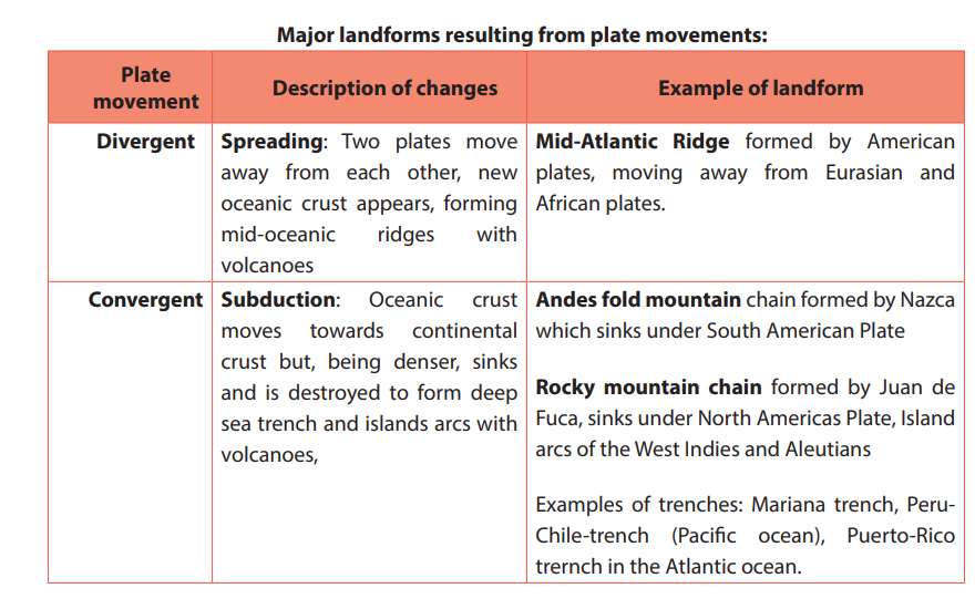
• Divergence is a movement whereby two crustal plates are moving away from
each other. The margin where this process occurs is known as a constructive
plate boundary. It initially produces rifts which eventually become rift valleys.
• Way past is plates’ movement predominantly horizontal, where crust is neitherproduced nor destroyed as the plates slide horizontally past each other.
The plate movements are characterized by the following:
• Due to its relatively low density, continental crust does not sink; but it is the
oceanic crust which is denser that can sink. Oceanic crust is then formed and
destroyed, continuously;
• Continental plates, such as the Eurasian plate, may consist of both continental
and oceanic crust;
• Continental crust may extend far beyond the margins of the landmass;
• Plates cannot overlap. This means that either they must be pushed upwards
on impact to form mountains, or one plate must be forced to downwards into
the mantle;
• No gap may occur on the earth’s surface so, if two plates are moving apart new
oceanic crust originating from the mantle is formed;
• The Earth is neither expanding nor shrinking in size. Thus, when the new
oceanic crust is being formed in one place, older oceanic crust is being
destroyed in another;
• Plate movement is slow and is usually continuous. Sudden movements are detected as earthquakes;
• Most significant landforms (folded mountains, volcanoes, insular arcs deep seatrenches, and batholith intrusion) are found at plate boundaries.
3.4.4 Characteristics of plate tectonics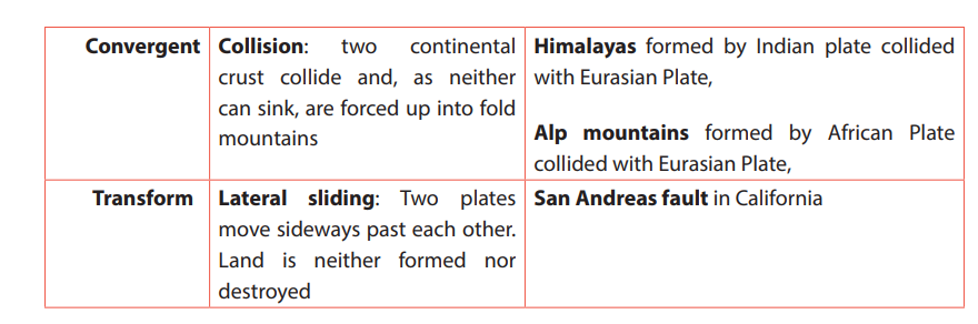
Tectonic plates are characterized by the construction and destruction of landforms
at margins of plates. However, at some boundaries, the construction or destruction
may not occur. These are called passive margins or conservative boundaries.
i. Constructive landforms
Constructive landforms occur where two plates diverge, or move away from each
other, and a new crust is created at the boundary. They are formed in the following
ways:
• This occurs when a continent ruptures and the two new plates move apart and
create a new ocean.
• The crust is uplifted and stretched apart, causing it to break into blocks that
become tilted on faults. Eventually a long narrow rift valley appears.
• Magma rises up from the mantle to continually fill the widening crack at the
center (A) as presented on figure below.
• The magma solidifies to form new crust in the rift valley floor.
• Crustal blocks on either side slip down along a succession of steep faults, creating mountains.
• A narrow ocean is formed, floored by new oceanic crust (B)as presented onfigure below.
• The ocean basin can continue to widen until a large ocean has been formed
and the continents are widely separated.
• The ocean basin widens, while the passive continental margins subside and
receive sediments from the continents.
• As the plates diverge, molten rock or magma rises from the mantle to fill anypossible gaps between them, creating new oceanic crust.
• The magma initially forms submarine volcanoes which may in time grow
above sea-level. Volcanic islands are created by the submarine volcanism atthe vertical of oceanic ridge, e.g. Iceland (see the figure below).
ii. Destructive landforms
Destructive landforms occur where continental and oceanic plates converge. They
are formed in the following ways:
• The oceanic plate that is denser is forced to dip downwards at an angle to form
a subduction zone with its associated deep-sea trench.
• The sunk plate will melt and transformed into magma as the pressure and the
temperature rise.
• The newly created magma will try to rise to the earth’s surface. Where it does
rich surface volcanoes will occur. This process will either create a long chain
of fold mountains (e.g. the Andes) or, if the eruptions take place off shore, an
Island arc will be created(e.g. Japan, Caribbean).
iii. Passive or conservative margins: Passive continental margins are: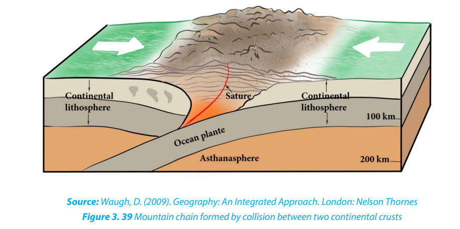
• The areas which are lacking active plate boundaries
at the contact of continental crust with oceanic crust.
• The transform faults which are large cracks produced at right-anglesto the plate boundary because neither landform is constructed nor destroyed.
Application activity 3.4
1. Describe SIAL and SIMA in terms of thickness, age, weight and nature of
rocks
2. Explain the difference between convergent movement, divergent
movement and way past movement
3. Describe the subduction, collision, spreading processes and give
their effects and corresponding motions in relation to plate tectonic
movements.
4. Explain the processes that lead to constructive and destructive landforms
3.5. Major plates and effects of plate tectonics
Learning activity 3.5
1. Make research using books and a printed hand out and represent on the
world map the major tectonic plates.2. Identify the effects of the plate tectonic?
3.5.1. Major tectonic plates of the world
The following are the major tectonic plates of the world:
i. The Pacific plate which covers a large part of the basin of Pacific Ocean.
ii. The Eurasian plate located between the northern mid-ocean ridge of the
Pacific Ocean and the Pacific and Philippines Plates margins.
iii. The North American plate bordered by the eastern margin of the Pacific
plate in the West and mid-ocean ridge of the Atlantic Ocean in the East.
iv. The South American Plate located between the subduction zone of
Nazca plate in the West and the mid-ocean ridge of the Atlantic Ocean in
the East.
v. The African plate located between the mid-ocean ridge of the Atlantic
Ocean in the West and the mid-ocean ridge of Indo-Australian plate in the
East.
vi. The Indo-Australian plate extends around the Australian subcontinent,
between the Pacific plate and the African Plate.
vii. The Antarctic plate corresponds with the Antarctic continent around the
South Pole.
viii. The Nazca Plate which is located between the Pacific plate and the South
American plate.
However, several minor plates, about 20 have been identified (e.g. Arabian plate,
Bismarck plate, Caribbean Plate, Carolina plate, Cocos plate, Juan de Fuca plate, Nazcaor East Pacific plate, Philippines plate, Scotia plate among others).
3.5.2. Effects of plate tectonics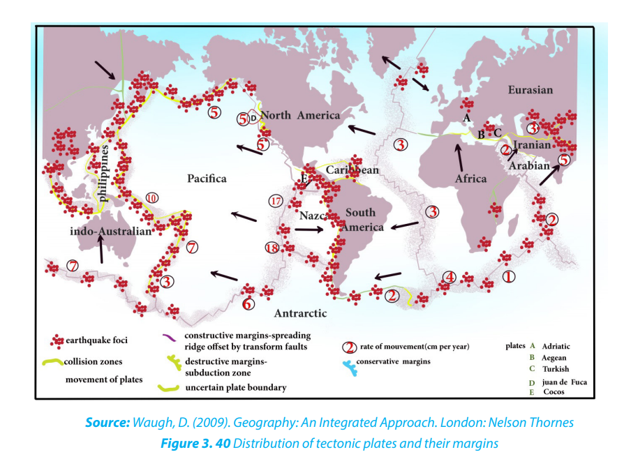
The following are the main effects of plate tectonics:
i. Earthquake
This is a series of vibrations induced in the earth’s crust by the abrupt separation
and echo of rocks in which elastic strain has been slowly accumulating. This sudden
violent shaking of the ground typically causes great destruction, because of
movements of seismic waves within the earth’s crust.
Most earthquakes occur as the result of the sudden movement along a fault line
between two adjacent tectonic plates. These have several impacts like landscapemodification, destruction of houses, tsunamis, etc.
ii. A volcanic eruption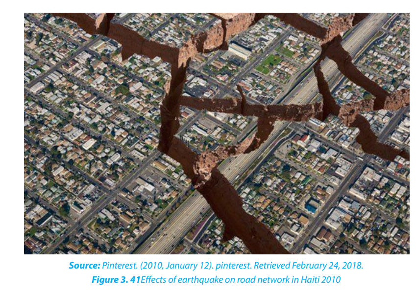
A volcanic eruption occurs when hot materials (molten materials) are thrown out of
a volcano. Lava, rocks, dust, and gas compounds are some of these materials which
are ejected out during volcanic eruption. Volcanic eruption take place when a plate
moves over the top of another plate, then the energy and friction melt the rock andpush it upwards.
iii. Tsunamis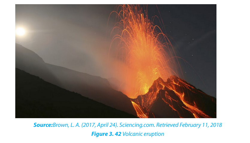
Tsunamis are giant waves, often generated at destructive plate margins that can cross
oceans. They occur when a sudden, large scale change in the area of an ocean bed
leads to the displacement of a large volume of water and the subsequent formation
of one or more huge waves. When a major seismic tremor occurs underneath a body
of water, the energy from that tremor is released into the surrounding liquid. The
energy spreads out from its original site, traveling through the water in the form of
a wave.
Tsunamis have exceptionally long wave-length up to 10 km and can cross oceans
at speeds of up to 700 km/hour but can sometime be imperceptible when theirmagnitude is low.
Application activity 3.5
1. Conduct your own research to identify the minor tectonic plates of the
world and locate them geographically.
2. Apart from the distribution of the continent, what are other effects of
plate tectonics.
3. Identify the major seismic and volcanic zones in the world and explain the
impact of those natural hazards referring to the tectonic plates.
4. Our country, Rwanda, is in a region which is tectonically active and
subjected to earthquakes events. The more documented earthquake
is the one which occurred on 3rd and 4th February 2008. It occurred on
Sunday about 09h31 with the magnitude of 6.1 and 5, and on Monday
the 4th February 2008 and affected mostly Nyamasheke and Rusizi
Districts, Western Province. 37 people died, and 643 injured including
367 traumatized. Many houses were destroyed in these two Districts
where 1,201 families were rendered homeless:
5. Knowing the causes of the earthquake, explain how Rwandans can copewith it and its impacts and other resulting natural hazards.
3.6. The theory of Isostasy
Learning activity 3.6
1. Make research and explain the isostasy theory.2. Explain isostasy based on the figure below.
3.6.1. Meaning of Isostasy
The concept of Isostasy comes from “iso” = equal, and “stasis” = equilibrium. It
describes how various continental and oceanic crusts, stay in equilibrium over the
asthenosphere. The following are the main characteristics of isostasy:
• By isostasy, the lighter crust must float on the denser underlying mantle.
• It explains how different topographic heights can exist on the earth’s surface.
• Isostatic equilibrium is an ideal which states where the crust and mantle would
settle in equilibrium in absence of disturbing forces.
• Isostasy theory is concerned with vertical movements of plates which depend
on lithospheric masses.
• The loading of crust by ice or sediments may cause the subsidence of
lithosphere, whereas the discharge resulting from ice melting or erosion may
cause the uplift of lithospheric compartment.
• The waxing and waning of ice sheets erosion, sedimentation, and extrusive
volcanism are examples of processes that perturb isostasy.
• Isostasy controls the regional elevations of continents and ocean floors in
accordance with the densities of their underlying rocks.
3.6.2. Main theories of Isostasy
There are two main theories which have been developed to explain how Isostasy
acts to support mountain masses.
i. Pratt’s theory: The theory stipulates that there are lateral changes in rock
density across the lithosphere (crust). If the mantle below is uniformly
dense, the less dense crustal blocks float higher to become mountains,whereas the denser blocks form basins and lowlands.
ii. Airy’s theory: According to Airys’s theory, the rock density across the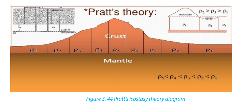
lithosphere is approximately the same but the crustal blocks have different
thicknesses. Therefore, mountains that shoot up higher also extend
deeper base into the denser material beneath.
Both theories predict a relative deficiency of mass under high mountains. Airy’s theory
is now known to be a better explanation of mountains within continental regions,
whereas Pratt’s theory essentially explains the difference between continents and
oceans, since the continent crust is largely of granitic composition which is less
dense than the basaltic ocean basin.
Application activity 3.6Referring to Pratt’s theory and Airy’s theory, explain the principle of Isostasy.
End unit assessment
1. What is the contribution of Wegner’s theory and others on the
distribution of continents?
2. Basing on the knowledge acquired in this unit, explain the relationship
between the earthquakes which occur in the region of the western rift
valley of Africa where Rwanda is located, with the continental drift.
3. Using a map represent graphically the main tectonic plates of the world
map.
4. Discuss the consequences of the plate tectonics on population in somespecific areas of the world.
UNIT 4 EXTERNAL LANDFORM PROCESSES AND RELATED FEATURES
TOPIC 1 Living in Society: Global communication and
Key unit competence: By the end of this unit, I should be able to demonstrate anunderstanding of different features resulting from external processes and their relationships with human activities.
4.1. Weathering
4.1.1. Types and processes of weathering
Learning activity 4.1
a. Making good use of the diagrams below explain the processes involved in
both physical and chemical weathering.
b. Make a research and compare the processes of soil formation and the
processes of weathering
a. Definition of weathering
Weathering refers to the process of disintegration and decomposition of rocks
‘insitu’ into small particles by the action of weather and living organisms.
Agents of weathering: temperature, rainfall (water), wind, animals and plants
(vegetation).
b. Types of weathering
There are three types of weathering namely physical or mechanical weathering,
chemical weathering and biological weathering which cuts across each of the
physical and chemical weathering.
1. Physical weathering
Physical weathering refers to the breakdown or disintegration of rocks, without
any change in the chemical or mineral composition of the rock being weathered.
Rocks disintegrate into smaller particles but maintain their previous chemical
characteristics. Only the physical size and shape change. Physical weathering is
mostly influenced by temperature changes.
Processes of physical weathering include:
i. Thermal expansion or insolation weathering
This process is caused by the changing of temperature ranges which causes
differential heating of minerals forming the rock. When heated dark minerals expand,faster than others resulting in cracking and fragmentation of the rock.

i. Exfoliation
This occurs when there is expansion of rocks during the day and contraction of rocks
during the night due to repeated temperature changes. It is common in arid and
semi-arid regions. This results into rocks of a few centimeters thick to start peelingoff (breaking away) leaving behind exfoliation domes.

ii. Freeze thaw
This process also called frost weathering (or frost shuttering) occurs due to water
that enters into the cracks of the rocks; this water freezes and expands exerting
pressure within cracks. Water from rain or melting snow and ice is trapped in a crack
or joint in the rock.
If the air temperature falls below freezing point, the water freezes and expands. As a
result, the rock becomes weak and breaks. This process is common in cold regions,
especially glacial, periglacial and high mountainous zones. The figure below shows
steps from infiltration of water into the rock to the condensation within rock fissure
which result in the fragmentation.
iii. Pressure release
The process of pressure release known as the unloading or dilatation weathering
occurs when materials on top are removed by erosion. This releases pressure, which
causes the materials below to expand and crack parallel to the surface.
iv. Salt crystallization
The process of salt crystallization weathering illustrated on the figure below occurs
when saline water (or water carrying salts in solution) passes through cracks and
joints in rocks. As it evaporates, the dissolved salts change into salt crystals. These
crystals expand within cracks as they are heated up and apply pressure on the rockleading to its breaking up.
v. Shrinkage weathering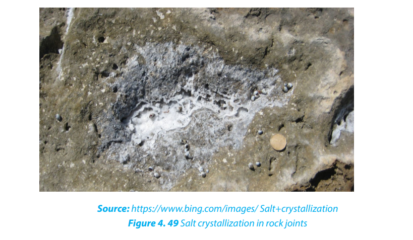
Some clayey rocks expand after absorbing water. For instance, there are some clays
which swell when they absorb water during rainy seasons. This results in increase
in volume. During dry seasons, they massively lose this water through evaporation
and they contract. This process is known as shrinkage. This alternating expansion of
these rocks during the wet season, and contraction during the dry season, creates
stresses and later cracks the rock.
vi. Granular disintegration
This takes place almost in the same way as exfoliation except that in this type, rocks
disintegrate into small particles called granules. It is produced either by differences
in thermal expansion and contraction, or through the frost heaving process
(congeliturbation).
2. Chemical weathering
This is a type of weathering which involves a complete change in the chemical and
mineralogical composition of the rock resulting into the disintegration of rocks. It is
common in areas which experience alternating wet and dry seasons.
The following are the chemical reactions that take place during weathering:
i. Oxidation: oxidation is one of the varieties of chemical weathering in which
oxygen dissolved in water reacts with certain rock minerals, especially iron,to form oxides.

ii. Carbonation occurs on rocks which contain calcium carbonate, such as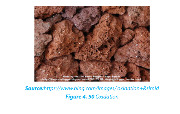
limestone and chalk. This takes place when rain combines with carbon
dioxide or an organic acid to form a weak carbonic acid.
iii. Dissolution: Dissolution is one of the less important forms of chemical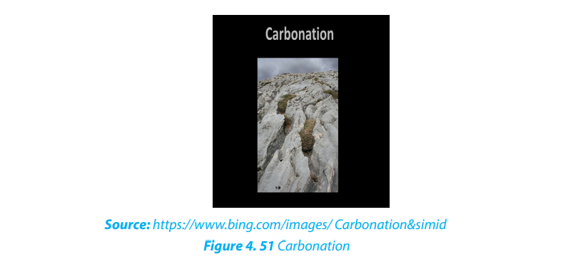
weathering, in which solid rocks are dissolved by water. When water (e.g.
rainwater) mixes with carbon dioxide gas in the air or in air pockets in soil,
a weak acid solution, called carbonic acid, is produced. When carbonic
acid flows through the cracks of some rocks, it chemically reacts withthe rock causing some of it to dissolve.
iv. Hydrolysis: Hydrolysis involves water combining with rock minerals to form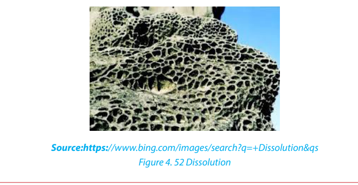
an insoluble precipitate like clay mineral. Compared to hydration-a physical
process in which water is simply absorbed – the hydrolysis process involves
active participation of water in chemical reactions to produce differentminerals.

v. Hydration: Hydration is one of the major processes of chemical weathering,
involving the addition of water to a mineral, causing it to expand and thereby
initiate stress within the rock. For example the conversion of hematite to
limonite. Once minerals have experienced hydration, they become more
susceptible to the effects of chemical weathering, especially those ofcarbonation and oxidation.

vi. Solution: is a process in which the minerals in the rock directly dissolve in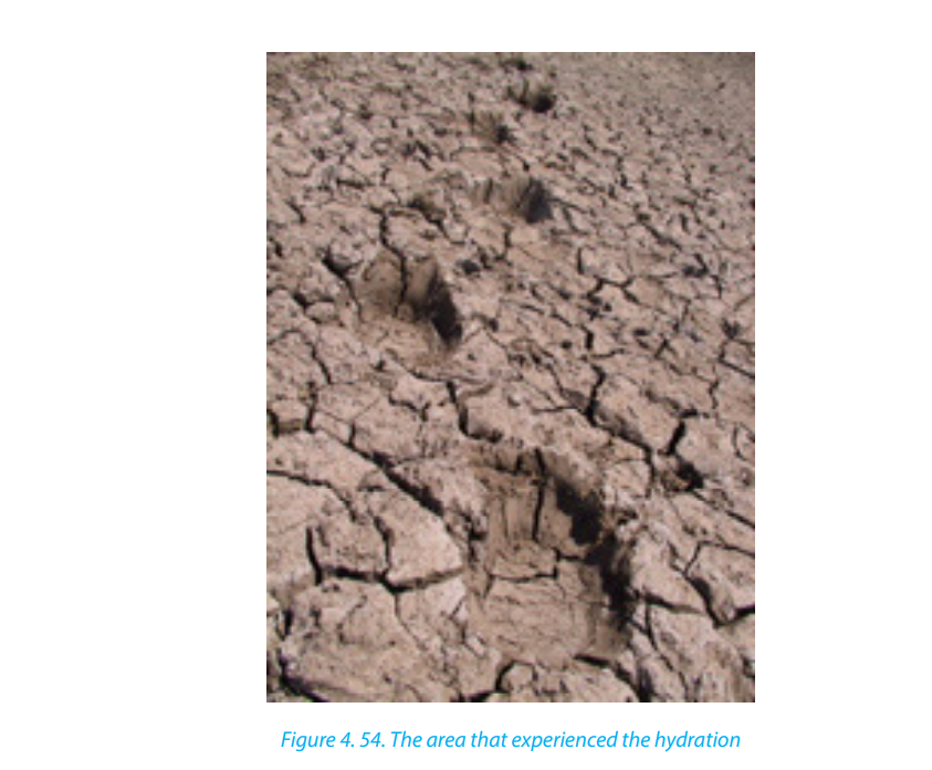
water without their chemical and mineralogical composition being altered.
e.g. olivine, Rock salt (calcium chloride) and calcium bicarbonate are easily
weathered in solution.
e.g. NaCl + H2
O → Na+, Cl- (dissolved ions with water).
vii. Chelation: Chelation is a complex organic process by which metallic cations
are incorporated into hydrocarbon molecules. In fact, the word chelate means
a coordination compound in which a central metallic ion is attached to an
organic molecule at two or more positions. Chelation is a form of chemicalweathering by plants.
3. Biological weathering
Biological weathering is a process of rock disintegration (decay) due to the influence
of living organisms both growing plants and animals. The diversity of life in soil
includes plants, algae, fungi, earthworms, flatworms, roundworms, insects, spiders
and mites, bacteria, and burrowing animals.
Plants wear away the rocks by their roots which widen the rock joints hence allowing
in other weathering agents like water to disintegrate the rocks. Some plant roots
also have chemicals at the tips of their roots which are acidic and hence cause rock
weathering.
Tree roots find their way into cracks or joints in the rocks. As they grow, they cause
the joints to become bigger. The end result is that the rocks break into smaller piecesat some points.
Burrowing animals like rodents and moles, warthogs (wild pigs) and wild animals in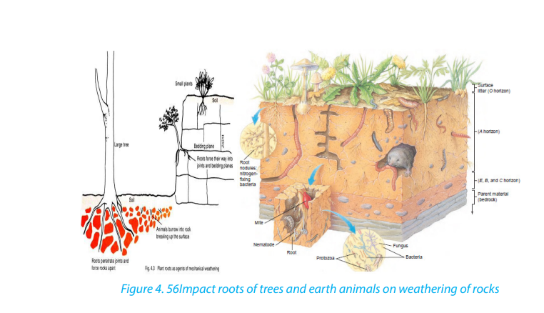
game parks like the chimpanzee, excavate the rocks and as such, they break up therocks hence weathering them. Man also disintegrates rocks through his activities.
Man’s activities such as mining, construction, quarrying, agriculture, etc. result in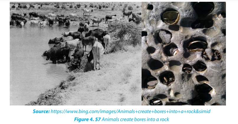
such a fast rate of disintegration of geomaterials (rocks).
Application Activity: 4.1
Use your local environment to identify the evidences of biological weathering.
4.2. Factors influencing weathering and interdependence of physical andchemical weathering
A number of factors are required for weathering to occur in any environment. The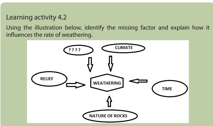
major factors of weathering include:
i. Relief
The term relief refers to the nature of landscape or topography. It influences
significantly the weathering process because it controls the flowing of run-off and
infiltration of water through slope exposition, steepness and length. In mountainous
regions, the windward slopes receive heavy rainfall which may speed up chemical
weathering, whereas the leeward sides receiving little amount of rain becoming
arid. This favors physical weathering to dominate on the lee ward part.
ii. Living organisms
Living organisms include plants and animals. They both contribute to weathering in
a number of ways. Growing roots of trees widen and deepen into the ground and
open up joints. Animals ranging from the big to small, including man affect the rate
of weathering both mechanically and chemically. Animals and micro-organisms mix
soils as they form burrows and pores, allowing moisture and gases to move about
iii. Time
The longer a rock is exposed to agents of weathering, the more weathered it is
likely to be and vice-versa. Young rocks such as solidified volcanic rock after a fresh
volcanic eruption are likely to be less weathered than rocks formed long ago.
iv. Climate
The key components of climate in weathering are moisture and temperature. The
type and amount of precipitation influence soil formation by affecting the movement
of ions and particles through the soil, and aid in the development of different
soil profiles. High temperatures and heavy rainfall increase the rate of chemical
weathering. Arid and semi-arid areas are associated with physical weathering since
there is low rainfall and high temperature. As the rocks expand during a period of
high temperature and contract during a period of low temperature they develop
cracks. In addition, equatorial regions with high rainfall and high temperature
experience fast and deep chemical weathering.
v. Nature of rocks
Nature of the rock determines the rate at which it may break down. Their nature
depends on rock forming minerals. Some minerals are easily soluble. Also
environmental condition such as organic acids and temperature may increase the
rate of weathering of rocks. Soft rocks, for example, break down more easily than
hard rocks. Similarly, jointed rocks (rocks with cracks) break down faster than rock
substances without joints.
vi. The interdependence of physical and chemical weathering
There is interdependence between mechanical and chemical weathering. Chemical
weathering to occur needs first mechanical process which provides fragmented
pieces of rocks. These rock fragments are then attacked by the chemical process of
weathering. Many reasons can be advanced to justify their interdependence:
• The joints and crack found in a rock as a result of physical weathering allow
deeper penetration of water which leads to chemical weathering.
• Some rocks are dissolved in water and weathered away in solution. The
solutions formed may later undergo precipitation leading to the formation of
crystal. These crystals will exert a lot of pressure that will disintegrate the rocks
physically.
• Hydration (chemical process) results in a high rate of absorbing water by
rocks .e.g.: hematite, limonite which makes these rocks to peel off in a physical
process called spheroidal weathering The physical process of frost shattering
opens up cracks in the rock and when these cracks are occupied by water,
chemical weathering process takes place. e.g. carbonation. Roots of plants
which expand within bedding planes of rocks and burrowing animals whichdrill holes in rocks allow water entry into these rocks which accelerates chemical weathering.
Application activity 4.2
Make a field study around your school and explain how relief and nature of the
rock have influenced the rate of weathering
4.3. Weathering in limestone regions
Learning activity 4.3
1. Differentiate the types of weathering.
2. Describe the type of rock associated with limestone regions.
Limestone is a sedimentary rock in which calcite (calcium carbonate: CaCO3) is the
predominant mineral, and with varying minor amounts of other minerals and clay.
Limestone rocks are very sensitive to organic acids derived from the decomposition
of living organisms.
The major landforms associated with weathering in limestone regions are Karsts
landforms that include: caverns, stalagmites, stalactites, pillar, dolines, limestone
pavements (uvalas), poljes.
i. Caverns
Caverns or caves are also one of the important characteristic features of groundwater
in limestone regions. Caverns are formed in several different ways. The rocks in which
most caverns occur are salt, gypsum, dolomite and limestone, with the latter by farthe most important.
ii. Doline
Doline also called Dolina is a round or elliptical hollow on the surface of a limestone
region which is formed when several small hollows merge. The small hollows are
formed when water starts acting on the points of convergence of joints on the
surface.
iii. Uvala
Uvala is a large surface depression (several km in diameter) in limestone terrain (karst
region). It is formed by the coalescence of adjoining dolines and has an irregularfloor which is not as smooth as that of Polje.
iv. Polje
Polje is a large depression in a karst region with steep sides and flat floor. If it is
drained by surface water sources, it is termed as open Polje.
v. Stalactites
Stalactites are protrusions on top of limestone cave formed as results of water
dissolving some rocks which form a solution that leaks from the roof.
vi. Stalagmites
Stalagmites are formed like a columnar concretion ascending from the floor of a cave.
It is formed from the re-precipitation of carbonate in calcite form perpendicularly
beneath a constant source of groundwater that drips off the lower tip of a stalactite
or percolates through the roof of a cave in a karst environment. It may eventually
combine with a stalactite to form a pillar.
vii. Pillars
Pillars are formed within the weathered limestone cave after the joining together of
stalactites from up and stalagmites from down. The two may finally meet forming apillar.
For karst land forms to be formed the following conditions must be in place:
• Precipitation: the major types of precipitation which contribute to
groundwater are rainfall and snowfall.
• Slope: infiltration is greater on flat areas since water is likely to remain in one
place for a long time given that other factors are favorable. On steep slopes, a
ot of water is lost through surface run-off with little infiltrating in the ground.
• Nature of the rock: For groundwater to percolate and accumulate there must
be spaces within the rocks for it to pass through as well as to occupy further
beneath.
• Vegetation cover: the presence of vegetation increases the rate of infiltration.
• Level of saturation of the ground: The rate of water infiltration is high whenthe ground is very dry and the soil is dry; all the air spaces in it are wide open.
Application activity 4.3
In groups make a field trip to any limestone region, observe karst landforms and
present your findings in class.
4.4. Weathering in humid tropical and arid regions and resultant
landforms
Learning activity 4.4
Choose any climatic region (Humid tropical/al/Arid) and identify the type ofweathering which will dominate the area
4.3.1. Humid tropical regions
The tropical climate is characterized by high amount of rainfall (more than 1000mm)
and high temperature of up to and (more than 18° C) respectively. Weathering is
favored in equatorial and tropical regions where the wetness and high temperature
are permanent. During the rainy season, chemical weathering dominates through
the process of hydration, hydrolysis, solution, oxidation, and reduction. In areas
with alternating seasons, chemical weathering is temporary interrupted during
drought periods because of lack of moisture. Physical weathering processes such
as exfoliation, granular disintegration and block disintegration dominate. Therefore,
in tropical (savanna) climate, both physical and chemical weathering processes
dominate in dry and rainy seasons alternatively.
4.3.2. Arid and desert regions and resultant landforms
The features formed in these regions as a result of weathering are both erosional
and depositional.
1. Erosional features
i. Inselbergs
An inselberg (island hill or mountain in German) called Monadnock in the United
States, is an isolated hill, knob, ridge, or small mountain that rises abruptly from a
gently sloping or virtually level surrounding plain. These forms are characterized by
their separation from the surrounding terrain and frequently by their independenceof the regional drainage network.
ii. Bornhardts
These are dome-shaped and steep-sided rocks that rise up to 30 meters. They are
massive rock, commonly granite comprised of bare rock that stretches several
hundred meters. They take many shapes such as oranges. A good example of where
Bornhardts are found is Central Australia.
iii. Tor
A tor is a pile like hill of rocks or rock peak. It is a product of massive weathering andcomes in all manner of shapes.
iv. Pediment
This is a rock that is gently inclined at an angle of 0.5 to 7 degrees. It is concave in
shape and is found at the base of hills where rainfall is heavy and falls over a short
period of time.
v. Deflation basins
Depressions are formed in the deserts due to removal of sand through the process
of deflation and are called deflation basins or blow-outs, or deserts hollows. The
depth of deflation is determined by groundwater table.
vi. Mushroom rock
The rocks having broad upper part and narrow base resembling an umbrella or
mushroom are called mushroom rocks or pedestal rocks. These undercut,mushroom shaped pedestal rocks are formed due to abrasive works of wind.
vii. Demoiselles
Demoiselles represent rock pillars having relatively resistant rocks at the top and
soft rocks below. These features are formed due to differential erosion of hard rocks
(less erosion) and soft rocks (more erosion). The demoiselles are maintained so longas the resistant cap rocks are seated at the top of the pillars.
viii. Zeugen
Rock masses of tabular form resembling a capped inkpot standing on softer rock
pedestal of shale, mudstone is called Zeugen. The bases of such features are broader
than their tops.
ix. Yardangs
These are formed always in the same way as Zeugens except that yardangs only
develop on landscapes which have alternating rock layers with different resistance
to erosion parallel to the direction of prevailing winds. Winds enter and scour up
rock particles from the soft bands, thus digging depressions within the soft bands.The resistant hard bands therefore remain standing high up as raised ridges.
x.Reg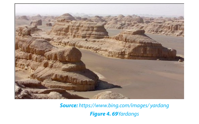
Reg is a desert surface armored with a pebble layer, resulting from long continued
deflation; found in the Sahara desert of North Africa. Often the winds blow off all the
smaller fragments, and leave the bigger size pebbles and gravels over an extensivearea.
xi.Oases
These are depressions that have water in deserts. These are created by strong winds
which remove rock particles from a particular place until a depression is excavated
(created).
2. Depositional features in desert
i. Dunes
Dunes are mounds or ridges of wind-blown sand. They are depositional features of
the sandy deserts and are generally mobile. They vary in size and structure. The main
types of sand dunes are Barchan, Transverse Dunes, and Seifs.
- Barkhans
Also called Barchans, these are typical crescent shaped sand dunes. The windward
slope of barchans is gentle and convex, and the leeward slope is steep and concave.
Barchans move slowly, at a rate of meters per year in the direction of the prevailingwinds.
- Seifs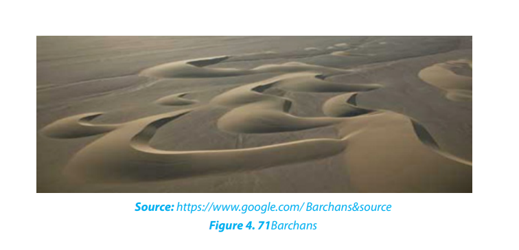
These are long and narrow sand ridge which grow parallel to the direction of theprevailing or dominant wind.
- Transverse dune
Transverse dune is an elongated dune lying at right angles to the prevailing wind
direction. They have a gentle sloping windward side and a steep sloping leeward
side, they are common in areas with enough sand and poor vegetation.
ii. Loess
Loess is a wind-blown deposit of fine silt and dust. It is unstratified, calcareous,
permeable, homogenous and generally yellowish in colour.
Application activity 4.4
Explain the reasons why the erosive power of wind is high in arid regions thanin tropical regions.
4.5. Weathering in the glaciated (cold) regions
Learning activity 4.5Observe the photographs provided below and answer the questions that follow:
4.5.1. Definitions
A glacier is a mass of ice of limited width, which moves outwards from a central
area of ice accumulation. In other words, a glacier is a mass of ice produced by the
accumulation and compression of snow, which moves slowly downhill or sea ward
due to its weight.
Glaciation or glacial activity refers to the work done by glaciers or moving ice. It is
a process of movement of ice usually from mountain tops downhill which leads to
erosional and depositional glacial landforms. Snow/ice is formed when temperature
falls under 0oC.
The permanent ice sheets occur in Greenland, Antarctica, and on high mountain
tops. The level above which there is perpetual snow cover is called a snow line.
In temperate regions, ice accumulation occurs in winter as the temperature falls
under 0oC, and melts later in summer. In tropical regions, snow accumulates on top
of mountains of about 4800m above sea level.
4.5.2. Types of glaciers
The main types of glaciers include the following:
i. Valley glaciers: these are also called alpine or mountain glaciers. They
move down slope and occupy former river valleys under the influence of
gravity and size. e.g. Glaciers on Rwenzori, Kilimanjaro, and Mount Kenya.
ii. Continental glaciers: are alternatively called ice sheets or ice caps. These
cover large areas of the plateau surface. They accumulate from a common
area and spread towards continental margins with massive movement.
e.g.: Glacier found in the polar regions of Greenland, Antarctica, Arctic,
Northern Canada and north Western Europe.
iii. Piedmont glaciers: these are produced when mountain glaciers move
down below the snow line and spread in the low lands of foot hills of
glaciated mountains. They merge to produce large mass of ice.
iv. Cirque glaciers: these are small accumulations of ice which occupy Cirque
basins on the mountain sides.
4.5.3. Types of glacial flow
Glacial movements are categorized into two types: gravity flow and Extrusion flow.
a. Gravity flow
In this process, glaciers move down slope under gravity
and it usually affects lowlying valleys. This kind of gravity flow includes
the following various types:
i. Plastic flowage: ice usually behaves as an elastic brittle solid. When more
ice accumulates, internal stress forces the ice to spread and therefore to
move like a highly viscous liquid.
ii. Regelation: when ice accumulates, pressure is created inside the ice
sheet. This pressure forces some ice to melt and this molten water moves
down-slope. When this water derived from the melting of ice reaches in an
area of low pressure, it freezes again and solidifies to produce ice.
iii. Intergranular translation: this involves the movement of crystals or
granules downslope due to pressure from overlying ice. Melt water
lubricates these ice crystals making it easy for them to slide past each
other.
b. Extrusion flow
As the accumulation of snow on ice caps increases,
there will be an automatic sideways displacement of ice
in all directions following increased accumulation. Hence
ice does not flow necessarily down slope as under gravity flow.
It flows in all directions as a thick porridge spreads
in all directions as more is added. This is how icesheets which cover large areas of plateau surfaces move.
Application activity: 4.5
Using examples distinguish between valley glaciers and continental glaciers.
4.6. Factors influencing the formation and movement of glaciers
Learning activity 4.6
Why is glaciation dominant in high altitude regions?
There are many factors that influence the formation of glaciers in an area. The most
important are briefly described in the following paragraphs:
The effect of altitude: Following the principle of altitude increase and temperature
decrease, glaciers usually form in areas of higher altitudes. e.g. Everest, Kilimanjaro
mountains.
• The factor of latitude: Areas that lie astride the equator within the tropics
have high temperatures that limit ice accumulation. On the other hand areas
far away from the equator have low temperature which favor ice formation.
• Precipitation of snow: Glaciers are formed from the condensation of water
vapor. This results in the formation of ice crystals which fall as snow. The
progressive accumulation and their compaction result in thick and continued
glaciers that cover the surface.
The rate at which glaciers move is different from glacier to glacier and is determined
by a number of factors. The most important are highlighted below:
- Nature of slope: when the slope is steep enough, glacier moves faster than
when slopes are gentle.
- The amount of ice or size of the glacier: when the glacier thickness is big,
there will be more pressure to generate quick motion than when the thickness
is low.
- Temperature: The glaciers are faster in warm climate conditions due to the
presence of enough melt water than in regions of low temperatures. High
temperatures quickly produce melt water, which lubricates the ground for
quick basal slippage and intergranular translation.
- The amount of load: Load is the eroded materials carried by a moving glacier.
The more the load the slower the glacier due to increase in friction and thelesser the load the faster the glacier will be.
Application activity 4.6
Make research on other factors that influence ice accumulation and make a class
presentation.
4.7. The work of glaciers and resultant landforms
Learning activity 4.7
From the experience you acquired in previous lessons, make a difference
between ice and glacier
4.7.1. Processes associated with glacial erosion
Glaciers perform a triple function. These are erosion, transportation, and deposition.
Many processes are associated with glacial erosion but the most important are the
abrasion, plucking and the frost shattering. They are detailed below:
- Abrasion also known as grinding process is the sandpapering effects
of angular material embedded in glacier as it rubs the valley sides and floor. Glacial
abrasion is caused by the rock debris embedded in the glacier.
- Plucking is also referred to as sapping or quarrying. It occurs when the ice at
the base and sides of the glacier freezes onto rock outcrops. The rocks are then
pulled and carried away by the moving ice.
- Frost shattering: this process produces much loose material which may fall
from valley sides onto the edges of the glacier to form lateral moraine.
4.7.2. Landforms produced by glaciers
There are two types of landforms performed by glacial processes:
1. Glacial erosional features
The most common glacial erosional landforms include:
- Cirque: also called corrie is a steep-sided rock basin with a semi-circular shape.
It starts from a small depression which is gradually enlarged. Frost shattering
helps shatter the rocks on the edges of the depression and as they break, the
depression is enlarged.
- Arêtes: an arête is a narrow ridge with steep sides developing between two
corries.
- Pyramidal peak: A pyramidal peak also called horn is a surviving top mountain
mass that is not yet worn down by erosion. It is shaped like a pyramid hence
the term “pyramidal peak”. It is formed at the junction of arêtes.
- Tan: also called tarn, is a cirque lake produced when the ice melts and the melt
water occupy the cirque depression.
- U-Shaped valley or glaciated trough: is formed when a glacier passes
through a pre-existing river valley to a characteristic of U shape profile. The
over deepening and widening of these former river valleys is a product of
abrasive action of ice using large amounts of moraine as its tool.
- Hanging valleys: these are valleys associated with glacial troughs. They are
small valleys whose floors are found at higher level than the floor of the main
valley to which they are tributaries. The floor of the main valley is at a lower
level due to greater erosion than the floor of tributary valleys where there is
less erosive power.

• Ribbon lakes: the floor of a glacial trough is often eroded very unevenly, and
long depressions may be formed at the U-shaped valley floor.
These depressions may become sites of long narrow lakes called Ribbon lakes, for example,
Lake Noir in France.
• Roche montane (roche moutonée): this is a mass of more resistant rock
that projects above the general level of a glaciated valley floor. In most glaciated valleys,
it is possible to find rock surfaces that have been grooved andscratched.
◊ Crag & Tail: This is an elongated rock mass which is formed when a flowing
glacier meets a resistant rock protecting a soft rock on its leeward side. Thesoft rock on the leeward side is called a tail.
2. Glacial depositional features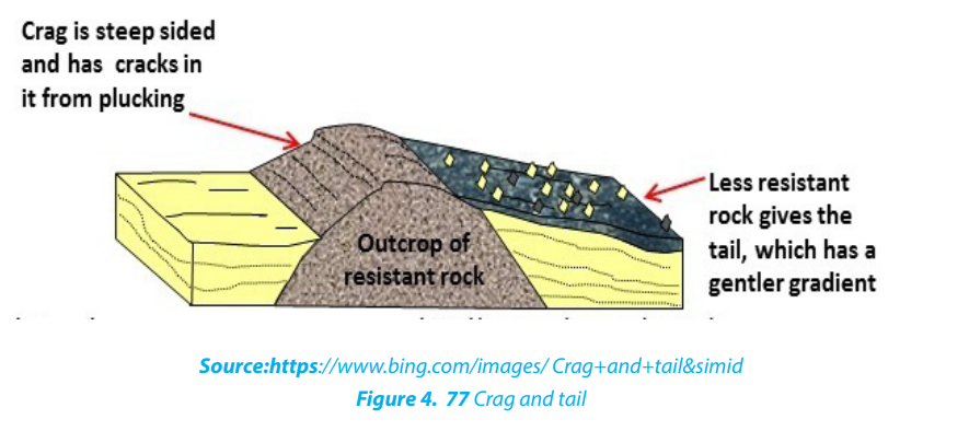
Deposition of debris is among processes performed by glaciers. Debris are
preferably deposited in depression or lowlands. Glacial deposits are generally calleddrifts. They include sands, gravels and rock boulders...
The major glacial depositional features are:
• Moraines
They refer to materials (debris) carried and later deposited by a glacier as it stagnates
or decay. Moraines can be classified into the following types:
- Terminal moraine: these are deposited on the mouth of a glacier.
- Lateral moraine: these are deposited on the sides of a glacial trough and from
elongated ridges on the sides of valley gorges.
- Medial moraine: These are materials that were originally carried by the valley
sides of two small valleys which after emerge into one valley. These materials
found themselves in the Centre of a glacier.
- Ground moraine: This type of moraine covers the entire width of the valley
floor.
• Till plains: these are extensive lowland areas covered by till or a till covered
plain.
• Fluvial glacial deposits: Fluvial glacial deposits are those materials deposited
by melt water from a stagnant glacier. They lead to the formation of the following depositional landforms:
• Outwash plain: is a wide gentle sloping plain which is composed mainly of
sand and gravel which were deposited by unevenly melt water
• Kame: is an irregular mound of sand and gravel deposited by melt water, they
are short lived and can collapse any time.
• Kame Terrace: is a flat topped ridge formed between a valley glacier and the
valley slopes. It is composed of materials deposited by melt water streams
flowing laterally to the glacier.
• Esker: is an elongated, narrow ridge which is made up of sand and gravel.
• Kettle holes: is a depression or hole formed by glacial deposits when a block
of ice detached from the main glacial while the latter is retreating.
• Drumlins: these are low, rounded smooth, elongated mounds or hills of tillrising up to 50m or 1km long. They are products of glacial deposits which flattened the landscape
Application activity 4.7
a. Account for the limited coverage of glaciation in East Africa.
b. Make a research and illustrate the major glacial depositional features.
4.8. Impact of glaciation on the landscape and to human activities
Learning activity 4.8
Using the experience acquired in previous lessons, identify different human
activities carried out in glaciated mountainous regions.
There are many impacts of glaciation on the landscape and human activities. Some
are positive while others are negative. The main impacts are described below:
4.8.1. Positive impacts
- Crop farming: the till and outwash plains contain fertile soils. These are some
of the richest agricultural areas in the world.
- Livestock rearing: the glaciated uplands provide suitable grazing lands since
they form fine benches on which pastures thrive in summer.
- Tourism: glaciated landscape has features such as arêtes, pyramidal peaks and
cirques that attract tourists.
- Natural harbors: fiords provide ideal sites for the development of natural
harbors, for example, the port of Rotterdam in Netherlands, natural habours in
Norway and Sweden.
- Fishing grounds: fiord coastlines such as those in Norway provide suitable
fishing grounds since they are deep and well sheltered.
- Provision of water: glacial lakes provide water for domestic and industrial
use.
- Transportation: glacial lakes provide natural waterways, for example, the
Great Lakes of North America.
- Mining: glacial erosion exposes minerals to the surface making their
exploitation easy, for example, gold and copper in the Canadian Shield of
North America.
- Generation of hydro-electric power: waterfalls formed by rivers flowing
through hanging valleys are suitable for the generation of hydro-electricpower, for example, in Switzerland.
4.8.2. Negative impacts
- Production of bare land: in some instances, the land surface has been
scrapped and polished to bare rock. Such regions are of no economic use.
- Discourage settlement: the cold temperatures especially at high altitude
limit settlement and other economic activities. They therefore remain as
wastelands.
- Transport barrier: the rugged landscape produced by glaciers makes it
difficult to establish infrastructure such as roads and railways.
- Hindrance to agriculture: sand and gravels deposited on outwash plainsmake the land unsuitable for agriculture.
Application activity 4.8
Make research using geographical documents and internet on negative effectsof glaciation apart from those mentioned in the content.
4.9. Mass wasting
Learning activity 4.9Observe and explain the phenomena that occurred in the photograph below

Mass wasting or mass movement is defined as the creeping, flowing, sliding or
falling of rocks and weathered materials down slope under gravity. It is different from
erosion in a sense that, in erosion water physically transports away the soil particles,
in mass wasting water does not wash away but assists the rock to slide down under
the influence of gravity. Mass wasting is classified into two major categories: Slow
movement and rapid movement.
4.9.1. Slow movement
Also called creep movements, they are very slow in their motion and they may occur
without being noticed. These slow movements’ include:
• Soil creep: This is the most common and the most widely spread type, because
it is found in both tropical and temperate climate. The movement of materials
is so slow that they may move a few centimeters per day. It can be detected byleaning of trees, electric poles and fencing poles in the direction of the slope.

• Solifluction: This is limited to glaciated mountainous regions and cold climatic
areas where thawing causes the saturated surface layer to creep as a mass overunderlying frozen ground.
• Talus creep: This is a down slope movement of mainly screes that are relatively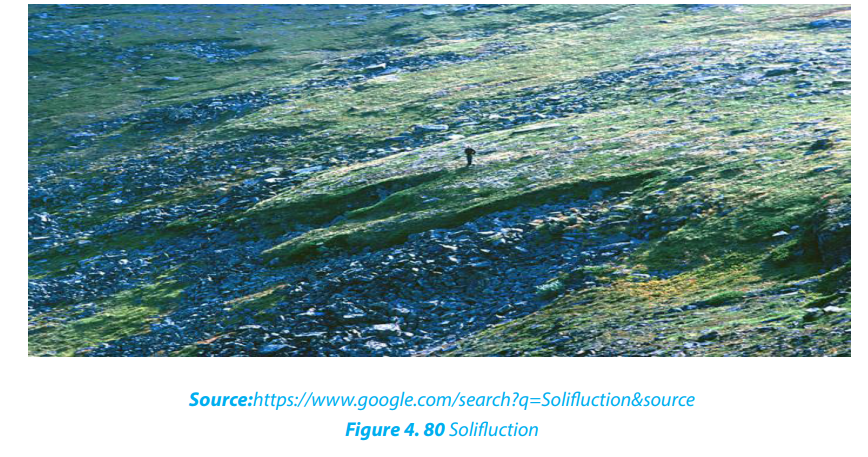
dry. It occurs almost in the same way as soil creep and it also occurs under
tropical and temperate climate.
• Rock glacier creep: This is a slow process of slope failure in which individual
rock boulders with very little soil but with some ice embedded within them
slowly move down slope confined within a channel.
• Rock creep: This is the movement of individual rock boulders slowly down
slope.
4.9.2. Rapid movement
• Earth flows: These are the rapid down ward movements of clayish or silty soils
along a steep slope.
• Mud flows: These are similar to earth flows but they are muddy and occur onslopes that receive heavy rainfall. They are very fast. In Rwanda they are common in the Northern and Western-provinces.
• Debris avalanches: This is the most form of rapid flowage due to the fact that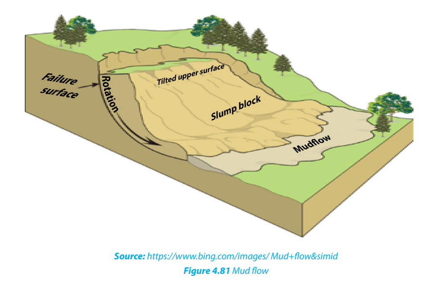
slopes are very steep and there is enough rain to soak slopes. It occurs on very
steep slopes that occur in humid climate.
• Slumping: This is the downward slipping of one or several units of rock debris,
usually with a backward rotation with respect to the slope over which movement takes place. Undercutting of slopes by streams and man are the main
causes of slumping. The surface of the slumped mass has a number of step-like
terraces.
• Rock slide: This is the type of sliding in which individual rock masses fall from
vertical cliffs or faces of slopes or jointed cliffs.• Rock fall: Here, individual boulders fall freely from a steep rock face.
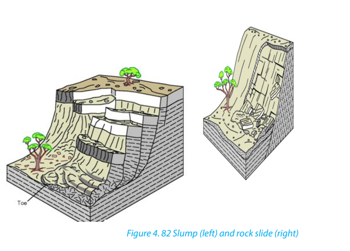
Landslides: These are also called landslips. They are down-slope gravitational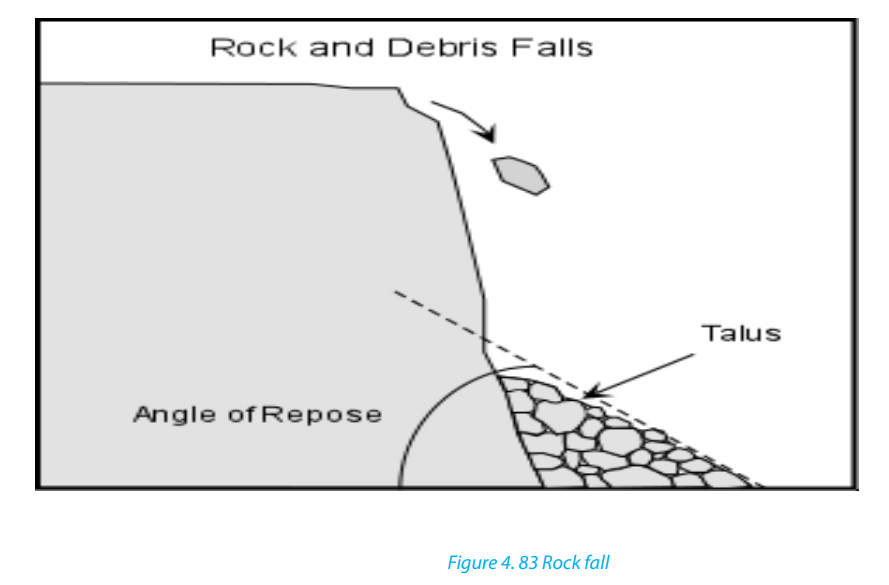
movements of a body of rock or earth as a unit. It may be induced by natural agencies
(like heavy rain, earthquake) or it may be caused by human interference with theslope stability.
Application Activity 4.9
Make research and analyze the types of mass wasting common on hilly areas of
Rwanda.
4.10. Causes, effects and control measures for mass wasting
Activity: 4.10.
Observe the photograph below taken in Gakenke district and describe thephenomenon that took place.
4.10.1. Causes of mass wasting
The following are the major causes of mass wasting:
- The degree of slope: The steeper the slope, the higher are the chances of
material movement. Mass wasting is almost nil in gentle and flat areas.
- The structure and lithology of rocks: Alternating hard and soft rock layers
on a slope can be a cause of slope fall. For example, a layer of clay on top of
limestone layer can easily slide down.
- The degree of lubrication: Most mass wasting processes occur after a heavy
down pour. Water assists to lubricate rock particles and the layers of rock
on top of a slope. Therefore, water provides a medium of sliding because it
reduces internal friction between rock particles and layers.- The amount of load on a slope: Slopes which are light rarely fall compared to
those which are heavy. Therefore, additional load on a slope increase chances
of slope fall.
- Tectonic movements: Earthquake and Volcanic eruptions cause vibrations of
the earth which often trigger off widespread movements of materials such as
landslides
- Climate: The amount and nature of rainfall received in an area determines the
kind of movement that occurs.
- Grazing: The grazing of cattle, movement of elephants and other animals can
cause some tremors on slopes hence making them fall.
- Nature of soil: soils which are infertile and therefore unable to support
vegetation in enough quantities, are more susceptible to mass wasting
compared to soils, which are fertile and therefore able to support dense
vegetation.
- Influence of vegetation: Vegetation help to hold rock materials together thus
reducing their movement on the surface.
- The work of animals: Animals and micro-organisms facilitate deep weathering
which results into the reduced cohesion of the rock particles on slopes. This
therefore leads to easy movement.
- Vulcanicity: Volcanic eruption on the ice capped highlands cause ice to melt
and therefore soak the slopes. This lubrication greatly increases the chances ofslope movement.
4.10.2. Effects of mass wasting
The following are some of the effects of mass wasting:
- Threat to life and property: There are several serious incidents of landslides
and rock slides every year. They cause loss of life and property. In a minor
incident they may block only one line of a road, but in severe cases entire
blocks of buildings collapse.
- Loss of vegetation: Mass wasting and soil erosion result in the loss of surface
topsoil which is essential for vegetation. As a result, more areas become barren.
- Scars and Gullies: In areas where topsoil and vegetation are removed, bare
spots form scars in the landscape. Gullies form on weathered slopes through
rain action and mass wasting in areas with little or no vegetation. Intense gully
cuts up the landscape into large-scale gullies and ridges and destroys the area.
Gullying is common in the bare, granitic areas.
- Pollution of water: large amounts of geologic materials enter streams as
sediments as a result of this landslide and erosion activity, thus reducing the
potability of the water and quality of habitat for fish and wildlife.
- Wildlife destruction: Although most kinds of wildlife are able to retreat fast
enough to avoid direct injury from all but the fastest-moving landslides, often
are subject to habitat damage by landslides.
It is noticed that mass wasting especially landslides, has severe impacts on humans
and environments. For this reason, measures have to be taken for preventing or
mitigating them. Some of the measures are highlighted below:
- Gradients of steeper slopes could be reduced by constructing terraces.
- Retaining walls can be built to stabilize the slope.
- Steep slopes should be inspected regularly, especially during periods of intense
or prolonged rainfall to identify areas prone to mass wasting for preventive
measures.
- More surface drainage channels and ditches can be constructed to reduce
overflowing discharge
- Legislation can restrict development and building in zones prone to mass
wasting.
- Trees can be planted on steeper slopes to stabilize the soil and the slope.
- Appropriate instruments can be installed to monitor slope stability, providing
early warning in areas of concern.
- Mass education of people
Application Activity 4.10
Make a field trip to observe different cases of mass wasting in your area. Analyseits causes and propose the sustainable measures to control it.
4.11. The relationship between weathering landforms and human
activities
Learning activity 4.11
Are landforms resulting from weathering important in your area? Support your
answer.
Weathering affects human activities in various ways as follows:
• Weathering provides a basis for the development of construction industry in
an area. e.g. marrum soil and laterite are good for road construction.
• Weathering can also produce landforms that offer important touristic opportunities.
• Weathering facilitates soil formation, this directly provides a basis for the development of agriculture in the region.
• Weathering affects limestone regions (calcium carbonate) that are important for cement production.
• Building stones in urban areas are subjected to the weathering processes as natural outcrops but with additional influences.
• Weathered shales also produce good brick clays, whereas the weathered basalt produces fertile soils based on montmorillonite.• On weathered rocks, weathering often improves the grade of economic deposits by concentrating desirable elements such as copper around the water table.
Application Activity 4.11
Make research in your area; describe how weathered landforms have benefitedthe people for their sustainable development.
End unit assessment
1. Describe the main causes of mass wasting that usually occur in northwestern part of Rwanda. How does the community work (umuganda)
contribute to the reduction of mass wasting in your area?
2. With reference to East Africa explain the formation of glacial landforms in
mountain areas.
3. How have topography and parent rock influenced the rate of weathering
in your area?
4. Make a field trip in your local environment and explain how the
weathering landforms identified in your area affect positively and
negatively human activities.
5. Referring to above questions suggest ways of sustainable environmentalprotection.
UNIT 5 WAVE EROSION AND DEPOSITION
TOPIC 2 Sustainable Development: Wealth Creation
Key unit competence: By the end of this unit, I should be able to categorize different features resulting
from wave action and their relationships with human activities.
1. What is the type of water body represented on the pictures above?
2. Identify the coastal landforms found on both pictures.
3. Explain the factors of the formation of the coastal landforms identified on
the map at right.
4. According to you, do you think the level of water in ocean is always the
same? Justify your answer.
5. If you need to be a business man / woman at the coastal regions,
explain the business opportunities that you may carry out there and the
challenges you can face.
5.1 Coastal landforms: definition of key terms
Learning activity 5.1
1. Using internet and different books, research and describe the difference
between the following terms related to coastal landforms:
a. Coast
b. Shore
c. Wave
d. Longshore drift
2. Identify the parts of a wave
Definition of key terms:
Below are defined different terms associated with the coastal landforms:
• Coast: A coast refers to the land that borders the sea or the ocean. It is a narrow
zone where the land and the sea overlap and directly interact. Some coasts are
made up of broad sandy beaches, while others form rocky cliffs or low-lying
wetlands. The shape of the coastline is determined by factors such as the typesof rocks present, the forces of erosion, and the changes in sea level.
• Shore: This is the area where land meets the sea or ocean. Different features
are found in this area resulting from erosion and deposition of sediments,
ocean or sea waves, as well as the effects of rivers as they join the sea. It is also
called coastline.
• Waves: Waves are defined as undulations of sea/lake water characterized by
well-developed crests and troughs (see the figure below). Waves are created
by the transfer of energy from the wind blowing over the surface of the sea.
When waves appear with high frequency they demonstrate the short wavelengths.
When they appear with low frequency they demonstrate long wavelengths.
However, there are special waves like Tsunamis that result from submarine
shock waves by earthquakes or volcanic activities.
• Longshore drift: This refers to the movement of sediments along the shore in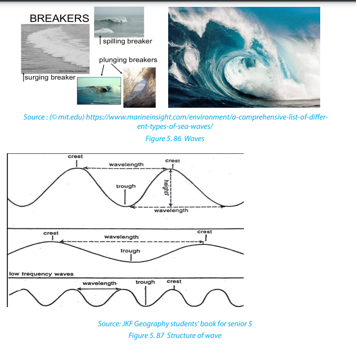
a zigzag pattern. Sediments produced by the erosive action of waves or sediments
transported by the river systems are moved by ocean waves and ocean
currents to form beaches. Sediments are as well moved offshore onto
the continental shelf. Most waves reach the shore at an angle of about 10° but this can
change depending on the wind direction. Each successive wave moves sand
at an angle along the beach face. Consequently, currents within the surfacezone flow along the shore as longshore drift (see the figures below).
Application activity 5.1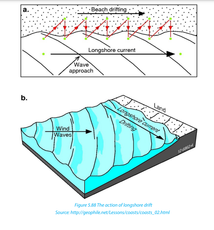
1. By using a diagram, demonstrate the parts of a wave.
2. Differentiate a shore from a longshore drift.
3. If you find an occasion to visit the Indian ocean coast in East Africa, describe
the coastal features you would be interested to discover.
5.2 Types, factors and action processes of waves
Learning activity 5.2
1. Using internet and other resources, describe the types of waves.
2. A coast may have the steep slope like cliff or gentle slope like beach.
Explain different ways by which waves may hit the coast depending on its
slope.
3. Visit a water body in your local area, observe the waves movement and do
the following:
i. Find out the causes of wave movement
ii. Identify the direction of wind on water surface
iii. Determine the direction of waves in water
iv. Describe the effect of wind on wave4. Explain how waves can cause erosion along the coast.
5.2.1 Types of waves
There are two main types of waves: constructive waves and destructive waves.
1. Constructive waves: These are waves whose swash is more powerful than
backwash. They are depositional in nature.
2. Destructive waves: These are waves whose backwash is more powerful
than swash. They are erosional in nature.
Other types of waves:
• Breaking waves: Formed when the wave collapses on top of itself. They are
of two types:
(i) Plunging breaker: The wave reaches a steeper beach and curls, moving over
a pocket of air. It travels very fast.
(ii) Spilling breaker: The wave reaches a sloping sandy beach, dispersing the
energy over a large area.
• Deep water waves/Swell waves: Are made up of a number of waves of
different lengths superimposed on each other. They are straight and long,
powerful, and travel great distance.
• Inshore waves: These waves drain the beach as a backwash.
• Internal waves: Formed due to the disturbances found between two water
masses of different density. They are high and become turbulent currents
when they hit a landmass.
• Kelvin waves: Formed due to lack of winds in the Pacific Ocean. They are high
and wide waves, warmer than the surrounding water.
• Progressive waves: Move with a steady speed, so they are called Progressive
Waves. They are of two types:
• Capillary waves: Formed when wind creates pressure over capillarity, the
binding force that holds the water molecules of the ocean surface together.
• Orbital progressive waves: Formed at the boundary of two liquids with
different density.
• Refracted waves: Travel in shallow water when they approach the shore. The
shallowness decreases the power of the wave and causes a curve. These are
usually seen near headlands and bays.
• Seiche waves: Caused due to the movement within a confined space. These
have long wavelengths and rarely result in any damage as their height is
generally short.
• Shallow water waves: Move in shallow waters. They are of two kinds:
• Tidal waves: Formed due to the gravitational pull of the sun and the moon on
the ocean.
• Seismic sea Waves/tsunami: Caused due to earthquakes beneath the ocean.
They travel extremely fast in open water, have significant height in shallow
water, and are very dangerous and devastating.
• Swell waves/Surging waves: Intense waves generating from the center
of a storm where the winds are strong. These expel little energy, travel long
distance, and break on distant shores.
5.2.2 Factors determining the strength of waves
The following are the major factors determining the strength of waves.
- Wind strength: Wind must be moving faster than the wave crests for energy
transfer to continue;
- Wind duration: Winds that blow for a short time will not generate large waves;
- Fetch: The uninterrupted distance over which the wind blows without
changing direction;
- Depth of water or roughness of sea bed: As waves enter shallow water their
speed decreases, wavelength decreases, and height increases. Waves therefore
tend to break in shallow water, for example over a bar at the entrance to a
harbor;
- Direction and speed of tide: If the tide direction is against the wind, this willalso increase wave height and decrease wavelength.
5.2.3 Wave action processes
The wave action includes erosion, transportation and deposition.
• Erosion: Several mechanical and chemical effects produce erosion of rocky
shorelines by waves. Depending on the geology of the coastline, nature
of wave attack, and long -term changes in sea-level as well as tidal ranges,
erosional landforms such as wave-cut, sea cliffs, and even unusual landforms
such as cases, sea arches, and sea stacks can form
• Transportation: Waves are excellent at transporting sand and small rock
fragments. These, in turn, are very good at rubbing and grinding surfaces
below and just above water level in a process known as abrasion. Longshore
drift, longshore currents, and tidal currents in combination determine the net
direction of sediment transport and areas of deposition.
• Deposition: Sediments transported by the waves along the shore are
deposited in areas of low wave energy and produce a variety of landforms,
including spits, tombolo, beaches, bars and barrier islands. Different types
of pediments are deposited along a coast, sometimes in the form of anaccumulation of unconsolidated materials such silt, sand and shingle.
Application activity 5.2
1. Explain the wave action processes.
2. Why do you think in some areas the wave action processes may occur
differently in nature?
3. Carry out a research in your local region to identify if there are wave
actions taking place.
4. Describe the particularities of Tsunami compared to other types of waves.
5. Explain the impact of wind and tides on the strength of the waves.
5.3. Formation of coastal landforms
Learning activity 5.3
1. Observe the following picture showing a coastal landform and answer thequestions that follow
a. What are the major factors for this landform to be formed?
b. Water level on photograph may increase or decrease. What are the causes
of such phenomena?
2. Using the internet and other geographical resources, describe the
following:
i. Wave erosion featuresii. Wave deposition features
5.3.1. Factors influencing the formation of coastal landforms
The following are the major factors influencing the formation of coastal landform:
- Tides: Tides are greatly influencing forces of coastal landforms. They are
commonly semi-diurnal (12-hour cycle). The rise and fall of water levels
produce oscillating currents known as tidal streams. Tidal currents can
transport large quantities of sediments, especially at the mouths of estuaries.
The tidal amplitude also determines the sediments deposition or erosion and
keep redefining the shoreline of coastal landforms.
- Waves: Waves contribute to the erosion of shore. The greater the wave action,
the higher is the erosion and sediment movement. Where the shoreline is long
and flatter, the wave energy gets dispersed. Wherever there are rock formations,
cliffs and short shore area, the wave energy is high. Strong waves can pick up
sediments from deeper waters and make them available for transportation by
the coastal currents. The larger the wave, the larger the particle it can move.
Storm waves can even move boulders. Even small waves can lift the sediments
and deposit along the coastal shoreline.
- Longshore currents: Parallel movement of water is known as longshore current
and it extends up to the zone of breaking waves from the coastal shoreline. As
the long shore currents are formed by refracting waves, the direction of flow
will depend upon the angle of the wave which in turn depends upon the wind
directions. If the wind direction is balanced, the sediment movement is also
balanced. If the wind movement and resultant wave action dominate in one
direction great volumes of sediment may be moved in one direction.
- Weather elements: The elements of climate, such as wind, rainfall and
temperature play an important role in formation of coastal landforms. Winds
are directly related to the intensity of waves. Landforms like coastal dunes are
created by wind action. Temperature is required for physical weathering of
sediments. Rainfalls provide runoff for producing and transporting sediments
from land to seashore.
- Gravity: Gravity is an important factor for the development of coastal
landforms. Gravity is indirectly involved in the movement of wind and waves
as well as in downward movement of sediments.
- Nature of coastal rocks: Soft rocks are easily eroded hence forming erosional
features like bays while hard or resistant rocks lead to the formation of
headlands.
5.3.2 Landforms produced by wave erosion
The coastal features formed due to marine erosion by sea waves and other currents
and solution processes include cliffs, caves, indented coastline, stacks, chimneys,
arch, inlets, wave-cut platforms.
Geography Senior Six Student Book 117
- Cliffs: A cliff is a steep rocky coast rising almost vertically aabove sea water.
Cliffs are very precipitous with overhanging crest. The steepness of vertical
cliffs depends on the following: lithology of the area, geological structure,
weathering, erosion of cliff face and marine erosion of cliff base.
- Wave-cut platform: Rock-cut flat surfaces in front of cliffs are
called wavecut platforms or simply shore platforms. They are slightly concave upward.
The origin and development of wave-cut platforms is related to cliff recession. The
plat-form is composed of bare rock or it may contain a temporary deposit orrock debris, pebbles or sand.
- Sea caves: A sea cave is a natural cavity or chamber which develops along
the coast due to gradual erosion of weak and strongly jointed rocks by up
rushing breaker waves (surf currents). Sea caves are more frequently formed
in carbonate rocks (limestone and chalks) because they are eroded more
by solution processes. However, sea caves are not permanent as they are
destroyed with time.
• - Blowhole: This is a vertical shaft linking the cave to the surface. It is formed
when wave action attacks the back part of the roof of the cave. At the same
time, weathering by solution acts on the line of weakness from the surface
downwards to form a blowhole.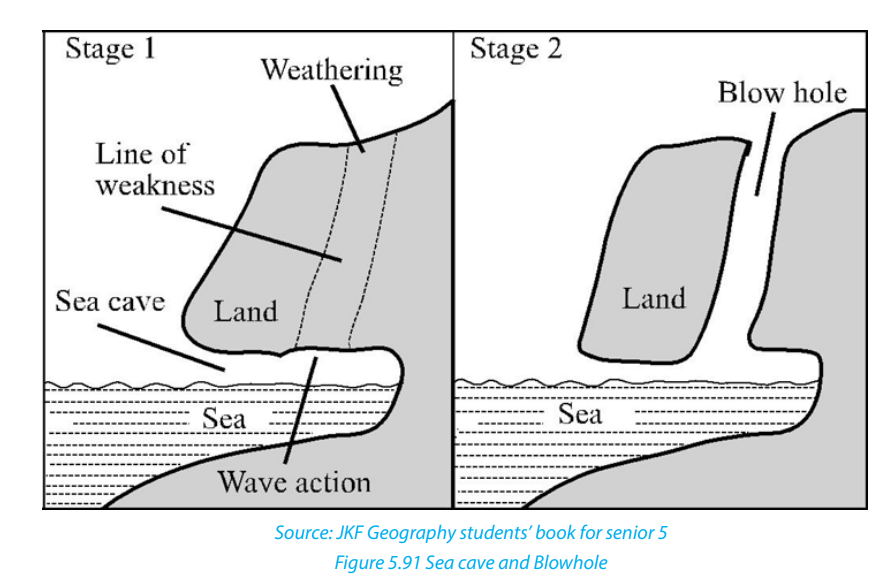
- Geo: Wave erosion may continue on the roof of the cave along the blowhole.
Hence, the roof of the cave may collapse to form a long and narrow sea inletknown as Geo.
Stack/ Column/Pillar: A stack is an isolated rock monolith or pillar rising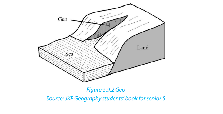
steeply from the sea. It is a former part of the adjoining land that has become
isolated from it by wave erosion, probably after having formed part of a marine
arch.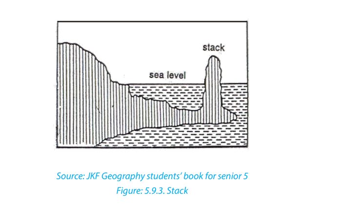
- Sea arch: A sea arch is a natural opening through a mass of rock limestone or
boulder clay. It is most commonly seen on the sea coast where waves have cut
through a promontory. When the keystone of the marine arch collapses, thefeature will become a stack.
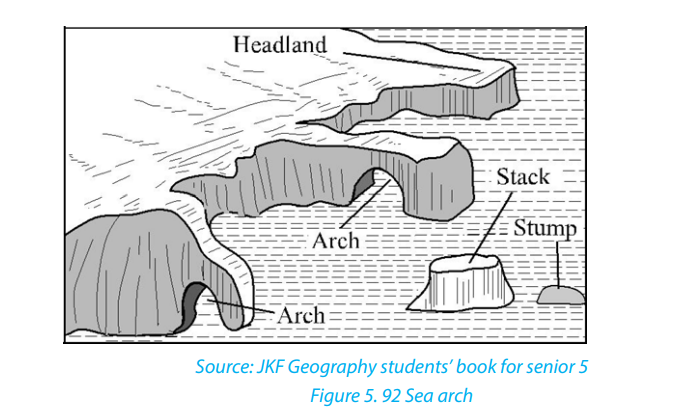
5.3.3 Landforms produced by wave deposition
Sediments transported along the shore are deposited in areas of low wave energy.
They produce a variety of landforms, including spits, tombolo, beaches, bars and
barrier islands. Different types of pediments are deposited along a coast, sometimes
in the form of an accumulation of unconsolidated materials such as silt, sand andshingle.
• Spits: A spit is an embankment composed of sand and shingle attached to the
land on one end and projecting seaward. It may form parallel to the coast and
stretch several kilometers. It may also grow at an angle across an estuary. Spits
are formed when materials are transported and deposited by the long shoredrift, mostly where the orientation of the coast changes.
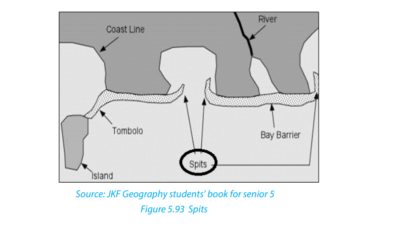
• Tombolo: It is a spit which grows seawards from the coast and joints to anisland.
• Beaches: A beach is located on a wave-cut platform of solid rock and is generally
of a low gradient with a gently concave platform. Beaches may extend for
hundreds of kilometers. Beaches are classified into: sand beach, shingle beach,and boulder beach.
• Bar: A bar is an elongated deposit of sand, shingle or mud occurring in the sea.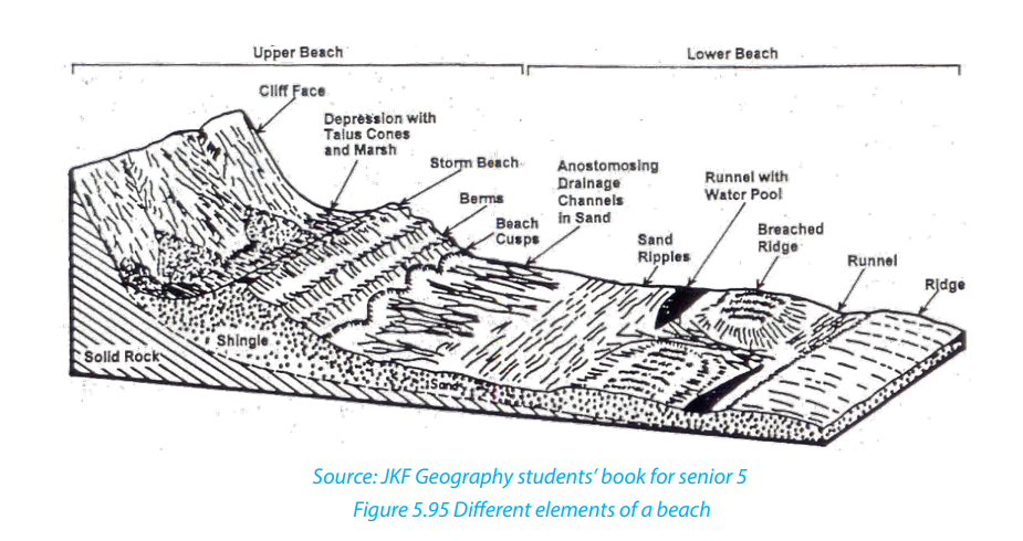
It is more or less parallel to the shoreline and sometimes linked to it. Bars may
be of submerged or emergent embankments of sand and gravel built along
the shore by waves and currents. One of the most common types of bars is thespit.
• Barrier Islands: Barrier Islands are long, offshore islands of sediments tending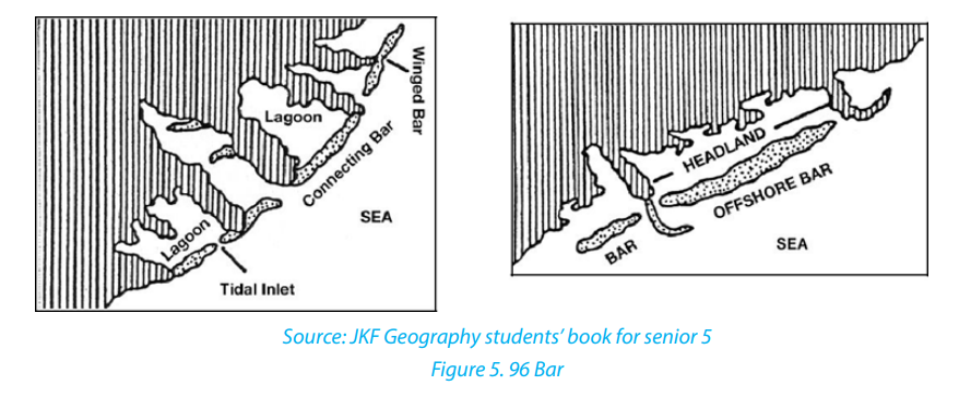
parallel to the shore. They form long shorelines adjacent to gently sloping
coastal plains, and they are typically separated from the mainland by a lagoon.Most barrier islands are cut by one or more tidal waves.
• Cuspate foreland: This is a large triangular-shaped deposit of sand, mud and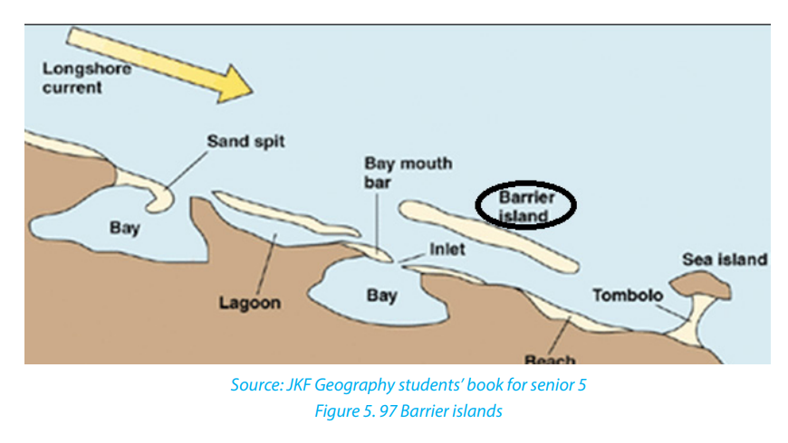
shingles projecting seaward. It is a rare feature formed when two adjacent spitsgrowing towards each other at an angle join and enclose a shallow lagoon.
• Mud flats: These are platforms of mud, silt and river alluvium kept
by salt tolerant plants to form a swamp or marshland. They are formed when tidesdeposit fine silts along gently sloping coats in bays and estuaries.
• Coastal dunes: These are low-lying mounds of fine sand, deposited further
inland from a wide beach by strong onshore winds. They are common in aridand semi-arid coasts.
Application activity 5.3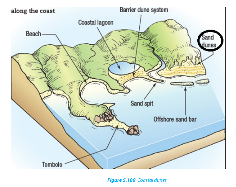
1. Describe landforms produced by wave deposition.
2. Explain the factors influencing the formation of coast landforms.
3. Describe the formation of features produced by wave erosion.4. According to you, which landforms are likely to find around lake Kivu?
5.4 Importance of coast landforms produced by wave action
Learning activity 5.4
Observe the following picture and describe the economic activities that can becarried out in this area.
Coastal landforms produced by wave action are very important in different ways as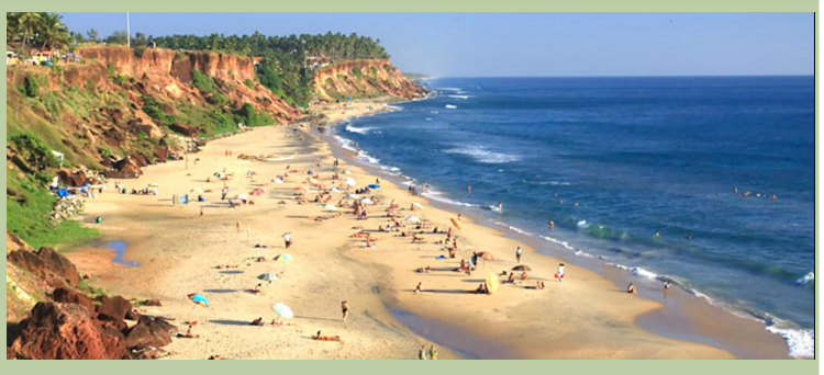
follows:
• Many of the world’s major cities are located in coastal areas, and a large portion of economic activities, are concentrated in these cities.
• There are different activities that take place in coastal zones including coastal
fisheries, aquaculture, industry, and shipping.
• Many of coastal landforms are very favourable for tourism that contributes to
the economic development of countries.
• The peculiar characteristic of coastal environments is their dynamic nature
which results from the transfer of matter, energy and living organisms between
land and sea systems, under the influence of primary driving forces that
include short-term weather, long-term climate, secular changes in sea level
and tides.
• Marine, estuary and coastal wetland areas often benefit from flows of nutrients
from the land and also from ocean upwelling which brings nutrient-rich water
to the surface. They thus tend to have particularly high biological productivity.
• It is estimated that 90 percent of the world’s fish production is dependent on
the nature of coastal landforms.
• The coastal landforms attract people as at present, two-thirds of the world’scities with a population of 2.5 million or more are situated near tidal estuaries.
Application activity 5.4
1. Give five examples of cities located in coastal areas, including at least
two located in East African Community.
2. Describe the main activities that are related to the Lake Kivu.
5.5. Types of coasts
Learning activity 5.5
1. Make your own research using internet or other geography resources and
identify different types of coasts.
2. Describe the areas subjected to fiords coasts.There are two types of coasts: Submerged coasts and Emerged coasts.
5.5.1. Submerged coasts
Submerged coasts fall into two categories: Submerged upland coasts and
submerged lowland coasts.
a. Submerged upland coasts
When the margin of an irregular upland area is submerged, a more or less indented
coastline is produced. It appears with islands and peninsulas representing the
former uplands, and with inlets indicating the former valleys. The following are thethree types of submerged coasts:
i. Ria coasts: Ria is a Spanish term widely used to describe a submerged
coastal valley or estuary resulting from a rise of the sea level. In the case
of a Ria coast, hills and river valleys meet the coastline at right angles. The
rias are characterized by funnel-shaped which decreases width and depth
as they run inland. The head of a stream which is small is responsible forthe formation of the valley at the inlet.
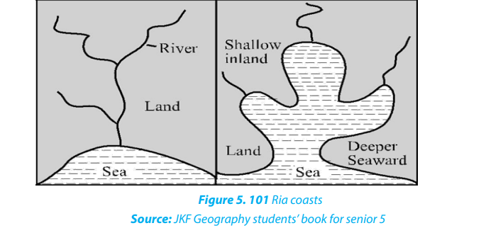
ii. Fiord (Fjord) coasts: A long, narrow inlet of the sea bound by steep mountain
slopes. These slopes are of great height and extend to considerable depths
(in excess of 1,000 m) below sea level. It is formed by the submergence of
glacially over deepened valleys due to a rising sea level after the melting
of the Pleistocene ice sheets. Fiords occur in western Scotland, Norway,
Ireland, Greenland, Labrador, British Columbia, Alaska, Southern Chile and
New Zealand. The main reason for their existence is the submergence of
deep glacial troughs and that is why fiords have many characteristics ofglaciated valleys.
iii. Dalmatian or longitudinal coasts: Dalmatian is a term derived from the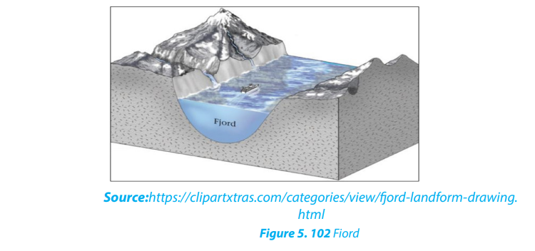
Yugoslavia Adriatic in which the coast runs parallel with the lineament of the
topography and probably with the underlying geological structure. A rise
of sea level (estuary) has drowned the coastal area, resulting in a coastline
of narrow peninsulas, lengthy gulfs and channels and linear islands. TheDalmatian coast tends to be straight and regular.
b. Submerged lowland coasts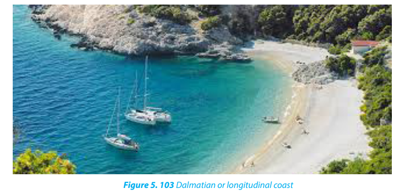
These are formed when a rise in the sea level drowns a lowland coast. The sea
penetrates deep inland along rivers to form estuaries. The rise in base level causes
an increase in deposition by rivers leading to formation of mud flats, marshes, andswamps which are visible at low tides.
Emerged coasts comprise emerged highlands coasts and emerged lowland coasts.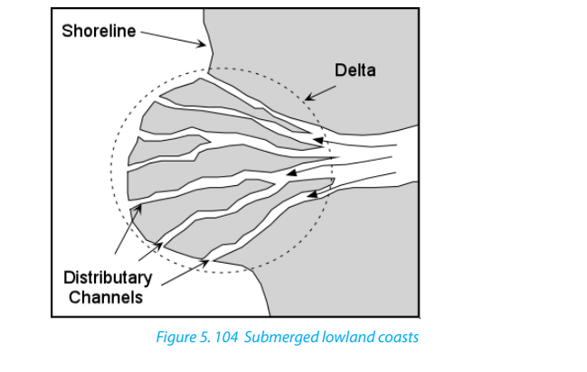
a. Emerged upland coasts
The chief feature of an emerged upland coast is a raised beach or cliff-line, found
above the present zone of wave action. The coastlines are revealed as distinct
notches in the slope, backed by a cliff, often with distinct caves. They are fronted by a
wave-cut rock platform covered with each material such as shell banks and shingles.
Many parts of the world show evidence of this emergence. The western coast of
Malta is a typical example of emerged upland coast.
b. Emerged lowland coasts
An emerged lowland coast has been produced by the uplift of part of the neighboring
continental shelf. The landward edge of such coastal plain is found in the southern
of USA. It is formed by the fall-line where rivers descend from the Appalachian in
a series of waterfalls. Other examples of emerged lowland coasts are: the northernshore of the Gulf of Mexico and the southern shore of the Rio-de-la Plata in Argentina.

Application activity 5.5
1. With help of diagrams describe different types of emerged coasts.
2. In a field trip at the lake shore in Rwanda (if any), indicate the type of thevisited submerged coast, and describe its characteristics.
5.6.1 Nature, types and formation of coral reefs
Coral reefs are significant submarine features. They are formed due to the
accumulation and compaction of skeletons of dead marine organisms known as
coral polyps. Coral polyps thrive in the tropical oceans. Numerous coral polyps live
at a place in groups in the form of a colony.
They are generally attached to submarine platforms or islands submerged under
seawater.
a. Types of coral reefs
On the basis of the location of the main types of reefs, we distinguish tropical coral
reefs and marginal belt coral reefs. But, by categorizing on the basis of the nature,
the shape and the mode of occurrence, we have three types of coral reefs which are:
fringing reefs, barrier reefs and atoll.
i. Fringing reefs (Shore Reefs): These are the coral reefs developed along the
continental margins or along the islands. The seaward slope is steep and
vertical while the landward slope is gentle. A fringing reef runs as a narrow
belt which grows from the deep sea bottom sloping steeply seaward side.It is separated from the main land by a narrow and shallow lagoon.
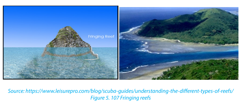
ii. Barrier reefs: Barrier reefs are extensive linear reef complexes that areparallel to a shore and are separated from it by a deep and wide lagoon.
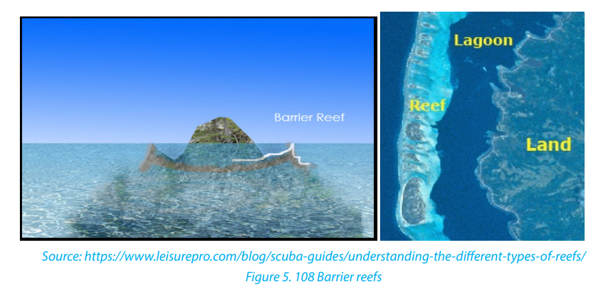
iii. Atoll: An atoll is a roughly circular (annular) oceanic reef system
surrounding a large and often deep central lagoon. There are three types
of atolls, namely, true atolls, island atolls and coral island or atoll islands.
• True atolls are characterized by circular reef enclosing a shallow lagoon but
without an island;
• Island atolls have an island in the central part of the lagoon enclosed by circular
reefs;
• Coral islands or atoll islands do not have islands in the beginning but later on
islands are formed due to erosion and deposition by marine waves
b. Formation of coral reefs
i. The process of coral reefs formation
Coral reefs start to form when the free-swimming coral larvae attach to the
submerged rocks or other hard surfaces along the edges of islands or continents.
This continues to grow under the influence of coral reefs conditions to grow in any
types accordingly. The coral reef formation takes three stages: fringing, barrier andatoll.
Concerning the process, a typical fringing reef is attached to or borders the shore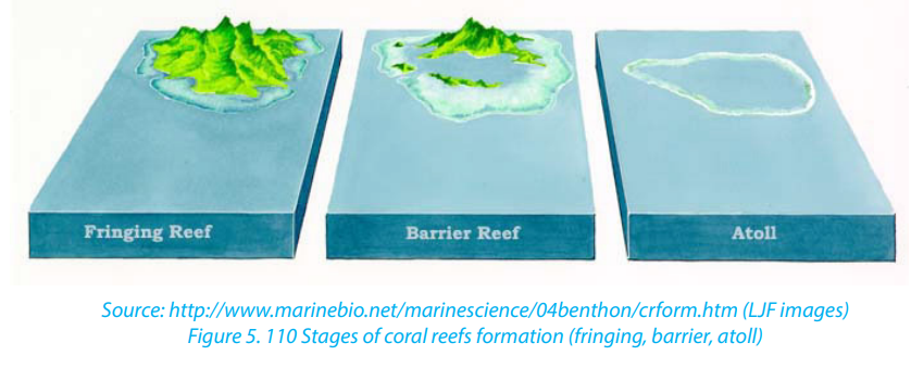
of a landmass, while a typical barrier reef is separated from the shore by a body of
water and an atoll began as a fringing reef around a volcanic island. Over time, the
volcano stopped erupting, and the island began to sink. Over time, coral growth at
the reef’s outer edge would push the top of the reef above the water. As the originalvolcanic island disappeared beneath the sea, only an atoll would remain.
The general conditions influencing coral formation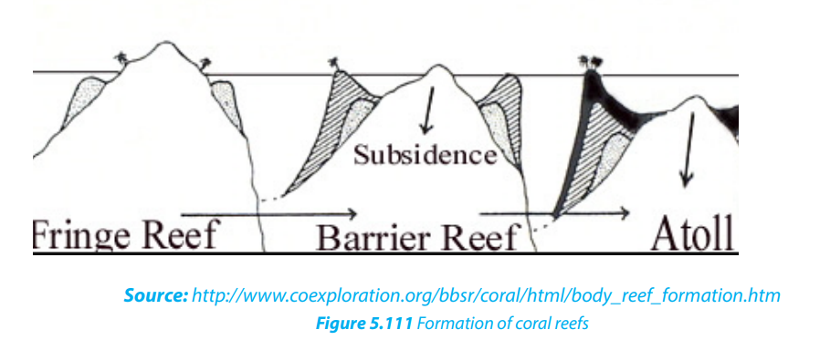
• Corals are found mainly in the tropical oceans and seas because they require
high mean annual temperature ranging between 20°C and 21°C for their
survival. They cannot survive in the waters having either very low temperature
or very high temperature.
• Corals do not live in deep waters, that is, not more than 60-77 meters below
the sea level.
• There should be clean sediment-free water because muddy water or turbid
water clogs the mouths of coral polyps resulting into their death.
• Though coral polyps require sediment-free water, fresh water is injurious to
their growth. This is why corals avoid coastal lands and live away from the
areas of river mouths.
• High salinity is injurious to the growth of coral polyps because such waters
contain little amount of calcium carbonates whereas lime is important food of
coral polyps. The oceanic salinity ranging between 27% and 30% is most ideal
for the growth and development of coral polyps.
• Ocean currents and waves are favorable for corals because they bring necessary
food supply for the polyps.
• There should be extensive submarine platforms for the formation of colonies
by the coral polyps. Besides, polyps also grow outward from the submarine
platforms.
• Human activities like deforestation, industrialization cause global warming,
which adversely affects corals in their habitats. Corals are more susceptible to
long-term climatic change. Corals are generally termed as rainforests of the
oceans. These cannot survive in extreme warm environment.
5.6.2 Theories of the origin of coral reefs
There are three main theories about the origin of coral reefs that are:
• The subsidence theory by Darwin,
• Antecedence theory by Murray,
• Glaciated control theory by Daly.
a. Darwin’s Subsidence Theory
• Darwin, a British naturalist developed his theory as follows:
• Darwin’s theory starts with a volcanic island which becomes extinct.
• As the island and ocean floor subside, coral growth builds a fringing reef, often
including a shallow lagoon between the land and the main reef.
• As the subsidence continues, the fringing reef becomes a larger barrier reef
further from the shore with a bigger and deeper lagoon inside.
• Ultimately, the island sinks below the sea, and the barrier reef becomes anatoll enclosing an open lagoon.
b. Murray’s antecedence theory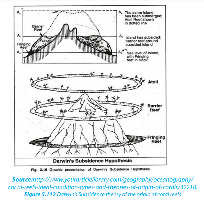
The Antecedent-Platform or uplift theory for the origin of coral reefs holds that:
• Any bench or bank that is located at a proper depth within the circumequatorial
coral-reef zone is potentially a coral-reef foundation.
• If ecological conditions permit, a reef may grow to the surface from such a
foundation without any change in sea-level.
• Reef foundations, or platforms, are formed by erosion, deposition, volcanic
eruption, or earth movement or by combinations of two or more of these
processes.
• Murray agreed that atoll coral reefs formed when the tops of islands were
undergone wave action resulting to a platform.
• Platforms originating below the depth limit of reef corals were veneered with
tuffaceous limestone and built to the zone of reef-coral growth by organisms
other than corals, chiefly foraminifera and algae.
c. Daly’s glaciated control theory
• Daly studied the coral reefs of Hawaii and he was greatly impressed by two
things:
• the reefs were very narrow and there were marks of glaciations
• there should be a close relationship between the growth of reefs and
temperature.
• According to Daly’s hypothesis, in the last glacial period, an ice sheet had
developed due to the fall in temperature. This caused a withdrawal of water,
equal to the weight of the ice sheet. This withdrawal lowered the sea level by
125-150 m.
• The corals which existed prior to the ice age had to face this fall in temperature
dining this age and they were also exposed to air when the sea level fell. As a
result, the corals were killed and the coral reefs and atolls were planed down
by sea erosion to the falling level of sea in that period.
• When the ice age ended, the temperature started rising and the ice sheet
melted. The water returned to the sea, which started rising. Due to the rise in
temperature and sea level, corals again started growing over the platforms
which were lowered due to marine erosion.
• As the sea level rose, the coral colonies also rose. The coral colonies developed
more on the circumference of the platforms because food and other facilities
were better available there than anywhere else.
• Hence, the shape of coral reefs took the form of the edges of submerged
platforms, a long coral reef developed on the continental shelf situated on
the coast of eastern Australia. Coral reefs and atolls developed on submerged
plateau tops. After the ice age, the surface of platforms was not affected by
any endogenic forces and the crust of the earth remained
5.6.3. Problems facing the development and growth of coral reefs
The following are the major problems facing the development and growth of coral
reefs:
• Overfishing: Increasing demand for food fish and tourism curios has resulted
in over fishing of not only deep-water commercial fish, but key reef species as
well. This affect the reef’s ecological balance and biodiversity.
• Coral disease: coral diseases contribute to the deterioration of coral reef
communities around the globe. Most diseases occur in response to the onset of
bacteria, fungi, and viruses.
• Destructive fishing methods: Fishing with dynamite, cyanide and other
methods that break up the fragile coral reef are highly unsustainable. Dynamite
and cyanide stun the fish, making them easier to catch. Damaging the coral
reef habitat on which the fish rely reduces the productivity of the area.
• Unsustainable tourism: Physical damage to the coral reefs can occur through
contact from careless swimmers, divers, and poorly placed boat anchors.
Hotels and resorts may also discharge untreated sewage and wastewater into
the ocean, polluting the water and encouraging the growth of algae, which
competes with corals for space on the reef.
• Coastal development: The growth of coastal cities and towns generates a
range of threats to nearby coral reefs. Coral reefs are biological assemblages
adapted to waters with low nutrient content, and the addition of nutrients
favours species that disrupt the balance of the reef communities.
• Pollution: Coral reefs need clean water to thrive. From litter to waste oil,
pollution is damaging reefs worldwide. Pollution from human activities inland
can damage coral reefs when transported by rivers into coastal waters.
• Marine debris: It is any solid object that enters coastal and ocean waters.
Debris may arrive directly from a ship or indirectly when washed out to sea
via rivers, streams, and storm drains. Human-made items tend to be the most
harmful such as plastics (from bags to balloons, hard hats to fishing line), glass,
metal, rubber (millions of tires!), and even entire vessels.
• Dredging operations. They are sometimes completed by cutting a path
through a coral reef, directly destroying the reef structure and killing any
organisms that live on it. Operations that directly destroy coral are often
intended to deepen or otherwise enlarge shipping channels or canals, due to
the fact that in many areas, removal of coral requires a permit, making it more
cost-effective and simple to avoid coral reefs if possible.
• Global Aquarium Trade: It is estimated that nearly 2 million people worldwide
keep marine aquariums. The great majority of marine aquaria are stocked
with species caught from the wild. This rapidly developing trade is seeing the
movement of charismatic fish species across borders. Threats from the trade
include the use of cyanide in collection, over-harvesting of target organisms
and high levels of mortality associated with poor husbandry practices and
insensitive shipping. Some regulation is in place to encourage the use of
sustainable collection methods and to raise industry standards.
• Alien invasive species: Species that, as a result of human activity, have been
moved, intentionally or unintentionally, into areas where they do not occur
naturally are called “introduced species” or “alien species”. In some cases where
natural controls such as predators or parasites of an introduced species are
lacking, the species may multiply rapidly, taking over its new environment,
often drastically altering the ecosystem and out-competing local organisms.
• Climate change: Rising sea levels due to climate change requires coral to grow
to stay close enough to the surface to continue photosynthesis. Also, water
temperature changes can induce coral bleaching coral bleaching as happened
during the 1998 and 2004 El Niño years, in which sea surface temperatures
rose well above normal, bleaching or killing many reefs.
• Ocean acidification: results from increases in atmospheric carbon dioxide. The
dissolved gas reacts with the water to form carbonic acid, and thus acidifies
the ocean. This decreasing pH is another issue for coral reefs.
• Coral mining: Both small scale harvesting by villagers and industrial scale
mining by companies are serious threats. Mining is usually done to produce
construction material which is valued as much as 50% cheaper than other
rocks, such as from quarries. The rocks are ground and mixed with other
materials, like cement to make concrete. Ancient coral used for construction
is known as coral rag. Building directly on the reef also takes its toll, altering
water circulation and the tides which bring the nutrients to the reef.
5.6.4 Impact and problems related to coastal landforms
Coastal landforms have crucial impact in world economic activities. These are:
• Tourist attraction: Coastal features like caves, beaches and arches are tourist
attractions.
• Development of harbors: Rias and fiords favor the development of deep
sheltered harbors.
• Industrial raw materials: Coral limestone provides raw materials for the
manufacture of cement. This is obtained from raised coral reefs.
• Fishing grounds: Fiords contain sheltered waters which are suitable for feeding
and development of fishing ports. Continental shelves contain shallow waters
which favor growth of planktons. This makes them rich fishing grounds.
• Habitat for marine life: Lagoons, mud flats and mangrove swamps are good
habitats for marine life. This has promoted the development of research on
marine life and establishment of marine parks.
• Impact on agriculture: emerged coasts have sand, gravel and bare rock. These
inhibit agriculture, especially crop farming.
• Transport barrier: coastal features such as sandbars and coral reefs inhibitwater transport and development of ports
Application activity 5.6
1. Using illustrative graphics, differentiate the types of coral reefs.
2. Explain the conditions for coral reefs formation.
3. Identify the problems related to coral reefs.
4. Establish the similarities of the subsidence, antecedence and glaciated
control theories of coral reefs formation.5. Describe the economic importance of coral reefs.
5.7 Isostatic and Eustatic changes on the coast
Learning activities 5.7
1. Basing on your knowledge on the concept of isostasy, do you think it can
be related to the isostatic and eustatic changes on the coast? Explain.2. Differentiate isostatic from Eustatic sea level change.
The sea level is not static, which causes the level on coast changing regularly. These
changes are discussed below:
5.7.1 Isostatic change
Isostatic sea level change is the result of an increase or decrease in the height of
the land. When the height of the land increases, the sea level falls and when the
height of the land decreases the sea level rises. Isostatic change is a local sea level
change whereas Eustatic change is a global sea level change.
• During an ice age, isostatic change is caused by the build-up of ice on the land.
As water is stored on the land in glaciers, the weight of the land increases and
the land sinks slightly, causing the sea level to rise slightly. This is referred to
as compression.
• When the ice melts at the end of an ice age, the land begins to rise up again
and the sea level falls. This is referred to decompression or isostatic rebound.
• Isostatic rebound takes place incredibly slowly and to this day, isostatic
rebounding is still taking place from the last ice age.
• Isostatic sea level change can also be caused by tectonic uplift or depression.
As this only takes place along plate boundaries, this sort of isostatic change
only takes place in certain areas of the world.
5.7.2 Eustatic Change
Eustatic change is when the sea level changes due to an alteration in the volume of
water in the oceans or, alternatively, a change in the shape of an ocean basin and
hence a change in the amount of water the sea can hold. Eustatic change is always a
global effect.
During and after an ice age, Eustatic change takes place.
• At the beginning of an ice age, the temperature falls and water is frozen and
stored in glaciers inland, suspending the hydrological cycle. This results in
water being taken out of the sea but not being put back in leading to an overall
fall in sea level. Conversely, as an ice age ends, the temperature begins to rise
and so the water stored in the glaciers will re-enter the hydrological cycle; and
the sea will be replenished, increasing the sea levels.
• Increases in temperature outside of an ice age also affect the sea level since
an increasing temperature causes the ice sheets to melt, putting more water
in the sea.
• The shape of the ocean basins can change due to tectonic movement. If the
ocean basins become larger, the volume of the oceans becomes larger but the
overall sea level will fall since there’s the same amount of water in the ocean.
Conversely, if the ocean basins get smaller, the volume of the oceans decreasesand the sea level rises accordingly
Application activity 5.7
1. Describe the isostatic and eustatic changes on the coast.2. Describe the effects of Eustatic change on the environment.
5.8. Sea level change
5.8.1 Meaning of sea level change and its resulting features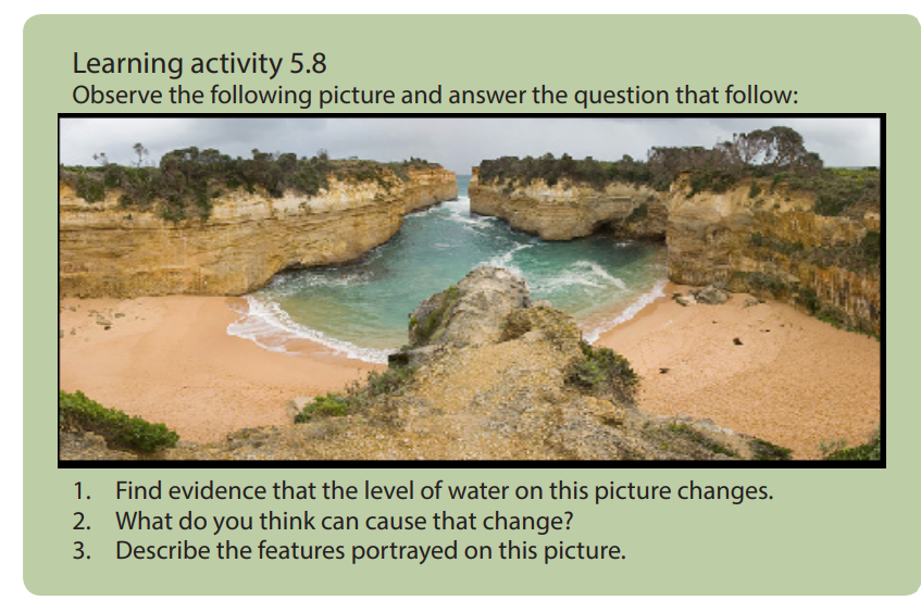
The sea level change is the variation and fluctuation of the sea level throughout
time. On a day to day basis, the sea level changes from the tide action but the sea
level also changes on a much grander time scale too. These changes in sea level
are normally caused by ice ages or other major global events. The sea level change
results from eustatic and isostatic changes. It can contribute to the formation of
submergent landforms such as Ria (a river valley that’s been flooded by the eustatic
rise in sea level), fjords and dalmatian coastline, and emergent landforms such as
raised beaches. These are wave-cut platforms and beaches that are above the current
sea level. There are also some old cliffs (relic cliffs) behind these raised beaches withwave-cut notches, arches and stacks along them.
5.8.2 Types of sea level changes
There are two types of sea level changes which are:
• Rise of sea level: This is referred to as an increase in global mean sea level as a
result of an increase in the volume of water in the world’s oceans. This leads to
the formation of coastal features of submergence.
• Fall of sea level: This is referred to as decrease in global mean sea level as
a result of a decrease of the world’s oceans. This leads to the production of
emergence coastal landform.
5.8.3 Causes of sea level change
The sea level changes daily because of the following causes:
• Eustatic variations in sea level are the effects of external forces. Most experts
agree that human induced global warming is the force behind the current
global sea-level rise. There are three factors that primarily affect eustatic sea
level change that are: thermal expansion of the ocean, melting of nonpolar
glaciers, and change in the volume of the ice caps of Antarctica and Greenland.
• The changes in global temperature affect the amount of ice stored on land
as water, thus changing the sea levels. A rise in temperatures causes the ice
caps to melt, and sea levels rise, and vice versa.
• The changes in sea levels are also affected by the steric effect. This is where
the density of the water increases or decreases as the temperature rises or falls.
If the temperature rises the water expands and if it falls the water contracts. It
is estimated that sea levels can rise up to 0.4 mm per year.
• The mass of ice adds weight to the earth’s crust causing it to sink lower into
the mantle resulting into relative rise in the sea-level during glacial period.
• Isostatic re-adjustment; at the end of glacial period, the mass of ice melts
and the weight is lost from crust which then rises. When the ice melts the land
begins to rise as the weight is removed. This results in a relative fall in sea-level.
This is called isostatic re-adjustment
• Uplift/mountain building due to plate movements may also result in a
relative fall in sea-level as land rises up.
• Pre-glacial erosion of a coastline causes the coast rise and end-up to the sea
level change.
5.8.4 Evidences of sea level changes
The following are evidences of sea level changes:
• The presence of old coastline high above the present sea level: During the
Ice Age the sea levels fall leaving the old coastline. Since the end of the Ice Age,
sea levels have risen again, but not to their previous levels. The raised beaches
continue to be above the present sea level by quite a distance.
• The estuaries and inlets flooded: Sea level rise after the last Ice Age caused
estuaries and inlets to be flooded. This occurred in South West England,
drowning many river valleys around the coasts of Devon and Cornwall, and
creating Rias. In other, more northern areas, glacial valleys were drowned to
create Fjords.
• Isostatic re-adjustment phenomenon: Some places in Scotland still
undergoing isostatic re-adjustment up to 7 mm per year in some areas.
5.8.5 Effects of the sea level changes
Rising sea level has many impacts on coastal areas. The following are some of them:
• Erosion of beaches and bluffs: Beach erosion is the most common problem
associated with rising sea level. Depending on beach composition, beaches
erode by about 50 to 200 times the rate of sea level rise. That translates a
2-millimeter (0.08-inch) per year increase in sea level eroding from 10 to 40
centimetres (3.9 to 15.6 inches) of coastline per year. Beach erosion has not
only a strong ecological impact, but also a profound economic impact.
• It increases the flooding and storm damage caused by changes in sea level.
• Contamination of drinking water: as the rising sea crawls farther and farther
up the shore, in many places it will seep into the freshwater sources in the
ground that many coastal areas rely on for their drinking water. Saltwater is
unsafe to drink, and while it is possible to remove the salt from water, doing so
is an expensive and complicated process.
• Interference with farming: Those same freshwater sources we use
for drinking also supply the water we use for irrigation. The problems here are the same:
The intruding sea could make these groundwater sources saltier. Saltwater can
stunt or even kill crops, but creating freshwater from saltwater is a costly and
unsustainable practice.
• Change in coastal plant life: more saltwater hitting the shores changes the
soil composition on the coast, meaning the plant life there will most likely
change as well.
• Threating the wildlife population: Many forms of wildlife make their home
on the beach. As the rising ocean erodes the shoreline and floods the areas in
which coastal animals live, animals like shorebirds and sea turtles will suffer
and die and others will migrate.
• Hurting the economy: the tourism and real-estate industries in coastal areas
are likely to take a hit as prime beachfront properties and recreational areas
are washed away by rising waters. This is a fact that some involved in theseindustries are finding hard to swallow.
Application activity 5.8
1. Explain the causes of sea level change
2. Describe the evidences of sea level change
3. Basing on the study of sea level change. Visit a local water body and
identify the evidences of its water level change.
4. According to you, which feature is more attractive to tourism. Defend your
view5. Explain the environmental effects of sea level changes.
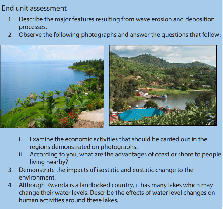
UNIT 6 ROCKS AND MINERALS
TOPIC 2 Sustainable Development: Wealth Creation
Key unit competence:
By the end of this unit, I should be able to assess the economic importance of rocks and minerals.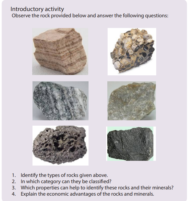 6.1. Rocks: Definition, types and characteristics
Learning Activity 6.1.
Observe the rock samples provided to you and identify their distinctivecharacteristics.
6.1.1. Definition
A rock is a natural aggregate of minerals in the solid state; usually hard and consisting
of one, two, or more mineral varieties. Rocks form the solid part of the earth’s crust.
Rocks may also include substances like clay, sandstones, shells and
corals. Rocks which contain metallic compounds are called ores.
6.1.2. Types of rocks
There are three major groups of rocks namely igneous rocks, sedimentary rocks
and metamorphic rocks. Their classification is based on the mode of formation and
the nature of constituting minerals. Characteristics of each rock group are briefly
described below.
i. Igneous rocks
The word igneous comes from the Latin word ignis, which means fire. Igneous rocks
are rocks formed by cooling of molten material from a volcano or from deep inside
the earth. This molten material from inside the earth is known as magma. Igneous
rocks are also called magmatic rocks or volcanic rocks. Their formation is associated
with the cooling and hardening of molten material from the interior of the earth.
ii. Sedimentary rocks
Sedimentary rocks are the result of the accumulation of small pieces broken off from
pre-existing rocks (igneous rocks, metamorphic rocks and sedimentary rocks) or
precipitation of dissolved minerals. Sedimentary rocks form when sediments become
pressed or cemented together or when sediments precipitate out of solution.
iii. Metamorphic rocks
The metamorphic rocks get their name from “meta” (change) and “morph” (form).
Metamorphic rocks are formed from pre-existing rocks due to increases in heat
and pressure which alter rock structure and chemical composition. Therefore,
sedimentary and igneous rocks can become metamorphic rocks.
There are four factors that contribute to the formation of metamorphic rocks:
• Heat or high temperature: this speeds up the chemical reactions that result in
metamorphic rocks. The heat is from magma, steam from hot water and rocks
sinking deeper into the warmer layer of the crust
• High pressure which changes the mineral and feel of the original rock.
• Nature of the parent rock which determines how resistance it is to
change.
• Time which determines the period required for the chemical reactions
to take place.
6.1.3. Characteristics of rocks
a. Characteristics of igneous rocks
Below are the characteristics of igneous rocks:
• Igneous rocks are hard, and water does not pass through their joints easily,
that is why they are less affected by erosion;
• They have a lot of minerals;
• They do not have strata or layers;
• They do not contain fossils (fossils are remains of plants and animals fixed in
rocks);
• The number of joints increases upwards in any igneousrock;
• Igneous rocks are mostly associated with volcanic activities and are mainly
found in the volcanic zones. That is why they are also called volcanic rocks.
Igneous rocks can also be characterized basing on their classification. According
to chemical and mineralogical characteristics, texture of grains, forms and size of
grains, and the mode of origin, igneous rocks are classified as follows:
i. Classification based on the amount of silica
• Acidic igneous rocks (having more silica: more 65% of SiO2
)
• Basic igneous rocks (having low amount of silica: less than 45% of SiO2
)
ii. Classification based on the chemical and mineral composition
• Felsic igneous rocks (composed of the dominant minerals of the light
group, Silicon, Aluminum)
• Mafic igneous (composed of the dominant mineral of dark group:
magnesium and iron)
iii. Classification based on texture of grains
• Pegmatitic igneous rocks, (very coarse grained igneous rocks) for
example, granite
• Phaneritic igneous rocks (coarse grained igneous rocks)
• Aphanitic igneous rocks (fine grained igneous rocks)
• Glassy igneous rocks (without grains of any size)
• Porphyritic igneous (mixed grained igneous rocks)
iv. Classification based on the mode of occurrence
• Intrusive igneous rocks: They are formed when the rising magma, during
a volcanic activity, does not reach the earth’s surface but rather cools
and solidifies below the surface of the earth. Intrusive igneous rocks fall
into two categories:
- Plutonic igneous rocks: are formed due to the cooling of magma very deep
inside the earth.
- Hypabyssal igneous rocks: are formed due to the cooling and solidification of
rising magma during volcanic activity in cracks, pores, crevices and hollow
places just beneath the earth’s surface.
• Extrusive igneous rocks: They are formed due to the cooling
and solidification of hot and molten lava on the earth’s surface (examples are basalt,
Gabbro). Extrusive igneous rocks are further divided into two major subcategories:
- Explosive type: The igneous rocks formed by a mixture of volcanic materials
ejected during explosive or violent volcanic eruptions.
- Quiet type: The appearance of lava through minor cracks and openings on
the earth’s surface is called ‘lava flow’. The lava forms basallic igneous rocksafter cooling and solidifying.

Figure 6. 114 Common Igneous rocks
b. Characteristics of sedimentary rocks
Sedimentary rocks have the following characteristics:
• Sedimentary rocks are the product of other rocks that have already formed;
• They appear in the form of layers or strata;
• They are formed from materials from the older rocks, plant and animal
remains;
• Sedimentary rocks are found over the largest surface area of the earth;
• Sedimentary rocks have various minerals because they are a product of
different sources;
• Most of the sedimentary rocks allow liquids and gases to pass through them
(permeable and porous);
• Sedimentary rocks are characterized by different sizes of joints;
• Sedimentation units in the sedimentary rocks having a thickness of greater
than one centimeter are called beds;
• As highlighted in the figure below, the composition of sedimentary rocks
includes clay, sand, rounded pebbles, angular fragments, calcium deposits
and organic carbon.
c. Characteristics of Metamorphic Rocks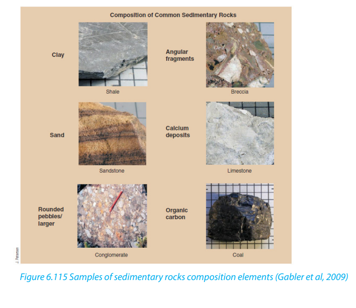
The following are the characteristics of metamorphic rocks:
• They are harder than the original rocks. Therefore, they are not easily eroded;
• They do not split easily;
• They contain minerals;
• Some are made up of just one mineral, for example, marble;
• They have a different texture or feel from the original rock.
Metamorphic rocks present two distinctive physical characteristics: Foliated
metamorphic rocks and Non-foliated metamorphic rocks. Foliated metamorphic rocks
such as gneiss, phyllite, schist and slate have a layered or banded appearance that
is produced by exposure to the heat and pressure. Non-foliated metamorphic rockssuch as hornfels, marble, quartzite do not have a layered or banded appearance.
Application activity 6.1.
1. In which area of Rwanda do we find igneous rocks? Explain their characteristics.
2. Observe rocks found in your environment and classify them in the majorrock groups.
6.2. Composition and properties of rocks
Learning activity 6.2.
Rocks are composed of physical and chemicals elements. Make a research on
internet and in other geographical resources and describe the physical andchemical properties of rocks.
6.2.1 Composition of rocks
All rocks are composed of minerals. Composition refers to both the types of minerals
within a rock and the overall chemical make-up of the rock. The mineral that composethe three types of rocks are presented in the table below.
6.2.2. Properties of rocks
i. Physical properties of rocks
Physical properties of a rock can be intensive (hardness and softness) and
extensive (volume, total mass and weight). Rocks, whether igneous, sedimentary or
metamorphic, are subject to powerful stress or pressure by tectonic forces and the
weight of overlying rocks. The physical properties of rocks determine their behaviour
and respective deformations when a rock is subject to stress such as folding, faulting
or warping, and their resulting landscape deformation (see the figure below).
• Stress refers to forces that constantly push, pull, or twist the earth crust. There
are three types of stress: tension (stretching), compression (shortening), and
shear (twisting or tearing).
• Strain is how rocks respond to stress whether by stretching, shortening,
shearing.
• The surface expressions refer to the structure of landforms resulting from
the stress depending on whether the rock is brittle (hard) or ductile (pliable).
Surface expressions can be folding (bending) or faulting (breaking). Brittle
rock breaks (brittle deformation) while ductile rocks like clay bend or flow
(ductile deformation).
The figure below presents different types of stresses that are naturally applied onrocks, their resulting strains and surface expressions.
ii. Chemical properties of rocks
a. Sedimentary rocks
All water falling onto the earth as rain and running over the earth surface carries
minerals in solution. These minerals may precipitate by direct evaporation of water,
chemical interaction or by the release of pressure where underground water reaches
the surface. Sedimentary rocks formed as chemical precipitates include halite,
gypsum, silcretes, ferricretes, limestone, and dolomite. The table below gives detailson their chemical composition.
b. Metamorphic rocks
Metamorphism involves the alteration of existing rocks either by excessive heat
and pressure or through the chemical action of fluids. This alteration can cause
chemical changes or structural modification to the minerals making up the rock.
Metamorphism process results in the creation of new minerals by the substitution,
removal, or addition of chemical ions. Metamorphism may consist of three
minerals, kyanite, andalusite and sillimanite. These are all aluminum silicates
having the same chemical formula (Al2SiO5) but different crystal structures and
physical properties.
Below is an example of a simplified representation of sediments products andresulting metamorphic rocks from sea beaches to far shelf.

c. Igneous Rocks
The major indicator for the chemical classification of igneous rocks is the amount of
Silica (SiO2). Igneous rocks with a high proportion of silica exceeding 65% are said to
be acidic or felsic, for example, the granite found on an extensive part of Muhanga
District of the Southern Province. Where the amount of silica is very low (less than
45%), the rocks are said to be ultramafic or ultrabasic. Rock having intermediate
silica content comprised between 65% and 45% are said to be mafic or basic rocks.
Igneous rocks are classified according to their forming minerals (see the table
below). Mineral groups include Felsic minerals (feldspars and silica), mafic minerals
(magnesium and iron), and ultramafic minerals (low silica content). Some of these
rocks form underneath the earth’s crust and are known as intrusive magmatic rocks,
whereas other form from the volcanic lave that reached the earth’s surface, formingextrusive volcanic rocks.

Application activity 6.2.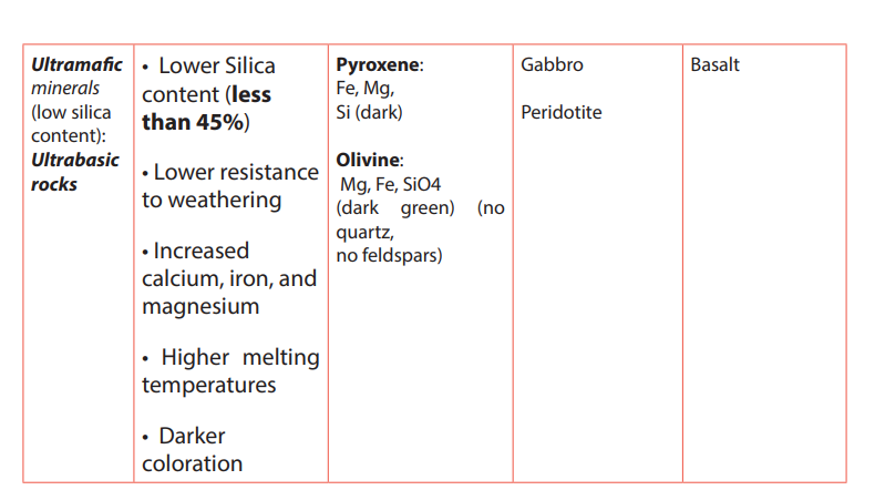
1. Referring to the properties of rocks, explain how rocks react to the stress
and the resulting landscapes?
2. Identify a sedimentary rock in your local environment and describe theprocess under which it might have been formed.
6.3. Impact of rocks: advantages and disadvantages on the landscape
and human
Learning activity 6.3
Make research using books and internet to explain briefly the advantages ofrocks on landscape and society.
6.3.1. Advantages of rocks on the landscape and human beingi. Advantages of rocks on the landscape• Some rocks are more resistant to weathering and others are less resistant. This
Advantages of rocks on landscapes are multiple:
difference in rock resistances provides various landscapes such as alternation
of elevated topographies (hills, mountains or interfluves) and depressions(valleys and low-lying areas) which are sometimes drained;
• Gravel and sand, being among products of rock weathering make beautiful
landscape at some location of the earth. Also, the weathering of rocks
provides different types of soils including sand, silt and clay which are useful at
varying points for agriculture.
• Some rocks present beautiful landscapes which may attract tourists;
• Some rocks store, purify water and act as water sources to rivers.ii. Advantage of rocks on human
Rocks have a wide variety of uses. Many of them are used as building materials of
houses and infrastructures such as roads and rail ways. The table below capturesusages of rocks.


6.3.2. Disadvantages of rocks on the landscape and human
i. Disadvantages of rocks on landscape
• Hard and resistant rocks hinder the penetration of plant roots hence, limiting
the weathering process or hindering the growth of vegetation;
• Rock forming minerals have different colours. The difference in colours make
minerals to absorb differently the heat. Dark-coloured minerals absorb
much heat during daytimes and therefore expand, causing the cracking and
fragmentation of rocks.
ii. Disadvantages of rocks on human
• The sand can blow, rocks can roll risking injury to people;
• Light-coloured rocks reflect sunlight and increase the temperature around the
plants during the daytime;
• Some environments such as sand rocks (dunes, reg, erg, etc.) are not suitable
for human settlement because of lack of water and soils;
• Some rocks may reflect landscape with steep slopes where human activitiessuch as agriculture or settlement cannot be possible.
Application activity 6.3.
1. Identify in your local environment the objects made from different rocks.
2. Observe your school buildings and describe different rocks used as
construction materials.
3. With relevant examples, discuss the disadvantages of rocks on landscapeand society
6.4. Minerals
Learning activity 6.4.
Use internet and books to search on the following:
1. Types and characteristics of minerals
2. The use of minerals to the society
6.4.1. Definition and characteristics of a mineral
A mineral is a solid inorganic substance that occurs naturally in the earth’s crust. A
mineral deposit is a concentration of naturally occurring solid material in or on theearth’s crust. Mineral resources are non-renewable.
There are five characteristics shared by all minerals.
i. All minerals are formed by natural processes. They can form when magma
cools, when liquids containing dissolved minerals evaporate, or when
particles precipitate from solution.
ii. Minerals are inorganic. They are not alive and are not made by life processes.
Coal, for instance, is made of carbon from living things. Although geologists
do not classify coal as a mineral, some people do. Miners, for example,
generally classify anything taken from the ground that has the commercial
value as a “mineral resource”.
iii. Minerals are solid and have a definite volume and shape. A gas such as air
and a liquid such as water aren’t minerals because they do not have definite
shape.
iv. Every mineral is an element or a compound with a chemical composition
unique to that mineral.
v. The atoms in a mineral are arranged in a pattern that is repeated over and
over again.
The table below shows two examples of mineral crystals (salt and quartz) withdefined shapes:
Note. Fuels like oil are not minerals because, as explained above, they do not meet the
following criteria of minerals:
• Inorganic (Oil is organic)
• Naturally occurring
• Solid (Oil is a liquid, and natural gas is not solid)
• Have a specific chemistry (Oil is mixture of various hydrocarbons with varying
chemistry)
• Internal crystalline structure
However, while Petroleum is not a mineral, it can contain mineral particles as sand
which is not a mineral often contains Quartz which is a mineral.
6.4.2. Types of minerals and ores
The wide varieties of minerals that have been explored by man for general and
commercial purposes to satisfy his needs are of two types: metallic minerals and
non-metallic minerals.
i. Metallic minerals
Metallic minerals include:
• Industrial metallic minerals: iron ore
• Ferroalloy metallic minerals: manganese, chromium, cobalt, molybdenum,
vanadium, nickel.
• Precious metallic minerals: gold, silver and platinum
ii. Non-metallic minerals
This category of non-metallic minerals includes salt, tin, potash, asbestos and
sulphur.
Rocks or minerals worked because they contain valuable (profitable) elements are
usually called ore-deposits. Minerals are extracted in a mineral ore. For instance,
Aluminum comes from the ore bauxite. The iron comes from the mineral ore
Hematite. A mineral can also be called an ore, for example Hematite is a mineral that
can also be called an ore. A mineral is an ore if it contains useful substance that can be
mined at a high profit and be processed and refined into more useful materials. For
instance, Aluminum can be refined from bauxite, and made into the useful products.
These products are worth more money than the cost of the mining, so bauxite is anore. The table below gives details on the main economic mineral ores.
6.4.3 Physical properties of minerals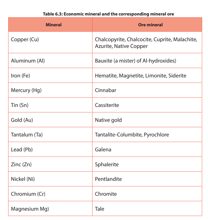
The most common minerals in earth’s crust can often be identified
in the field basing on their basic physical properties such as their
form, hardness, fracture, cleavage, colour, streak, density,
luster, mass, taste, odour, feel, magnetism as described
below:
i. Form: Definite geometrical forms called crystals can be recognized in
minerals. These are for example: cubic, acicular (needle shaped), columnar,fibrous, reniform (kidney shaped) and nodular forms.
Pyrite (left) has a cubic form; Tourmaline (middle) is prismatic; azurite and malachite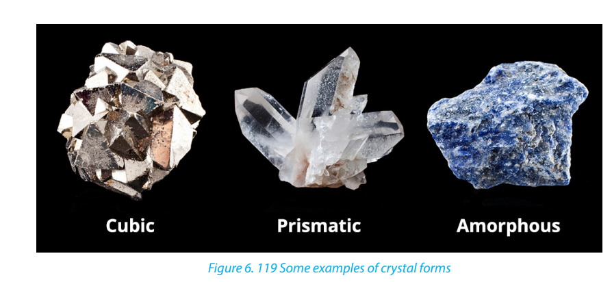
(right) are often amorphous.
ii. Hardness: The hardness of a mineral can be tested in several ways. Most
commonly, minerals are compared to an object of known hardness using
a scratch test developed by Friendrich Mohs. He assigned integer numbers
to each mineral, where 1 is the softest and 10 is the hardest. This scale isshown below.
If the gem minerals are excluded, the scale has only 7 numbers. Substitutes may be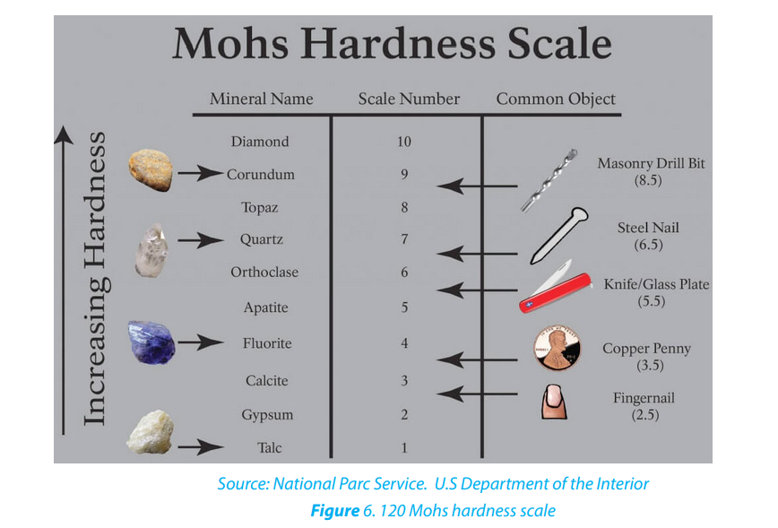
used when the scale minerals are not available:
• Easily scratched by nail;
• Not so easily scratched;
• Can be scratched by a piece (a copper coin);
• Scratched easily by knife;
• Can be scratched by knife with difficulty;
• Scratched by window-glass;
• Window-glass is scratched by the mineral.
iii. Fracture: Freshly broken surfaces of minerals present characteristic fracture
surfaces. The following important types are noted:
• Conchoidal (vitreous): the fracture surfaces are curved with a concave
or convex form; for example, quartz.
• Even: the fracture surfaces are nearly flat; for example, in chert.
• Uneven: the fracture surface is formed of minute elevations and depressions;
for example, most of minerals.
iv. Cleavage: This is how the mineral breaks. Certain minerals split easily along
certain planes called cleavage-planes. These planes are parallel to certain
faces of the mineral crystal, or to faces of a form in which the mineral may
crystallize.
v. Colour: When a body absorbs all the seven colours that make up white
light it appears black, and when it reflects all the colours it appears white.
When a body reflects the green vibrations of white light and absorb the
other vibrations it appears green. Thus, the colour of a body depends on
the selective reflection and absorption of the different vibrations of white
light.
vi. Streak: The colour of the powder of minerals sometimes differs from the
mineral in mass. Different specimens of the same mineral might show
variation in colour, yet the streak is fairly constant.
vii.Luster: The amount and the type of reflection from the surface of a mineral
determine its brightness. There are several types of luster, including the
following:
• Metallic: The luster of ordinary metals.
• Vitreous: The brightness of broken glass, for example, quartz.
• Resinous: The luster resembling that of resin.
• Pearly: The luster of peal. This is commonly seen in minerals that present more
or less platy surfaces.
• Silky: The luster similar to that of silk; generally shown by fibrous minerals like
some varieties of asbestos.
• Adamantine: The luster of diamond.
viii. Mass: The mass of a mineral can be used to identify its type.
ix. Density: The density of a mineral can also be used to determine its type.
x. Taste: Some of the minerals which are soluble in water give distinctive taste
but the character is not very useful in identification of minerals because
there are only a few minerals which are soluble is water. For example, we
get a saline taste in case of common salt, and alkaline in case of soda or
potash.
xi. Odour: Only a few minerals give characteristic odour, e.g. the odour of
garlic from arsenic compounds.
xii. Feel: Minerals differ in the sensation they give by touch, e.g. minerals are
smooth, greasy or rough.
xiii. Magnetism: Generally, iron bearing minerals are magnetic, but not
necessarily all iron bearing minerals are magnetic. Some non-magnetic
minerals like monazite are also slightly magnetic. The electromagnetic
minerals depend on the varying magnetism of different minerals.
6.4.4 Chemical properties of minerals
Some minerals are affected by the variations in temperature and the pressure on
the earth’s surface. Others vary in the structure depending on the percentage of
water that they loose with the change of the temperature and the pressure. The
chemical composition influences the destruction of the rocks and development of
new minerals.
Chemical properties of minerals are identified from their chemical composition. We
refer to two elements that are Silicon and oxygen. These are the two most abundant
elements in the earth crust. They constitute approximately 90% of the crust of
the earth. Then we distinguish silicate minerals and non-silicate minerals. Silicate
minerals (silicates) are minerals containing Silicon and Oxygen atoms usually withone or more other elements. Non-silicates are minerals other than silicate minerals.
6.4.5 Value of minerals and manufactured products
Minerals provide the material used to make most of the things of industrial-based
society; roads, cars, computers, fertilizers, etc. In more than 1600 minerals identi-
fied in earth crust, only 200 are extracted for commercial and industrial purposes
and less than 1/3 are the most economically significant.
i. Value of minerals
Some minerals have high economic value because of their uses or they are rare and
beautiful. For example, germs or Gemstones is a mineral with a distinctive colour
which makes it expensive. That is why it is used for jewellery. The value of minerals
depends on the following various factors:
• Chemical composition: Minerals containing (a) rare metals, (b) rare earths, (c)
several acid radicals have high value.
• Rarity: Rarity in minerals may be classified as due to the quality of the specimen
being greatly superior to the average, or to the scarcity of the species, variety
or form.
• Commercial value: If a mineral has only small commercial value this may be
disregarded in its appraisal.
• Form of a mineral: Large, perfect crystals, with brilliant faces and many of
them, or groups of such crystals, other things being equal, are the most valuable forms of minerals.
• Beauty of a mineral: Theoretically beauty is not a factor in scientific valuation,
as it is an element of art rather than science, but practically it is one of the most
important factors in determining the value of mineral specimens
• Size of a mineral: The mineral may be valued in proportion to their size,
though crystals of fine quality increase in value much more than proportionally
to their size.
• Hardness of a mineral: It has but slight mineralogical value, but it contributes
much to the commercial value of gems and it is the chief property of value in
the abrasives.
• Unusual characteristics: Freak specimens are always more valuable than
those which lack unusual characteristics. Thus a twisted tourmaline should be
worth two or three times as much as a simple crystal. A beryl broken, by nature
into several pieces with quartz filling the space between the pieces, will be
correctly appraised at several times as much as the same crystal in one piece.
• Associated minerals: While the associated minerals do not, as a rule, increase
the value of a specimen, there are many instances in which they do. This is
particularly true if the associates give a clue to the genesis of the mineral.Manufactured products from minerals

Application activity 6.4.
1. What are the five characteristics shared by all minerals?
2. Differentiate a mineral from an ore.
3. Explain the factors influencing the value of minerals.
4. Identify minerals that are extracted in your district and describe theiradvantages and disadvantages.
End unit assessment
1. Describe the distinctive characteristics of igneous rocks, metamorphic
rocks and sedimentary rocks and the places where they are found.
2. Explain the formation process of each major groups of rocks described
above.
3. Discuss the economic importance of rocks and minerals.
4. What is the difference between the physical and the chemical propertiesof the rocks?
UNIT 7 CLASSIFICATION OF SOILS AND SOIL FORMATIO
UNIT 7: CLASSIFICATION OF SOILS AND SOIL
FORMATION
Key unit competence:
By the end of this unit, I should be able to explain the factors and processes of soilformation.
Introductory activity 7:
Use internet and other geographical resources to research on factors and
processes responsible for soil differentiation and formation.
7.1 Classification of major soil types of the world
Learning activity 7.1
Make research on:
a. The major types of soils in the world.
b. The difference between zonal soils, azonal soils and intrazonal soils.
Soil is the uppermost layer of the land surface that plants use and depend on for
nutrients, water, and physical support. Soils consist of weathered rock mixed with
organic material that is derived from decaying plants and animals. There are three
major types of soils in the world, namely zonal soil, intrazonal soil and azonal soil.
7.1.1 Zonal soils
These are soils that cover a wide geographic region in the world. They depend on the
major climatic zones, vegetation and living organisms in areas where the landscape
and climate have been stable for a long time. They are common on gentle slopes.
They are found both in tropical and temperate regions.
This kind of soil has the following types: Tundra Soils, Podzols, Brown forest Soils,
Lateritic Soils / Latosols / Ferralsols, Chernozem / Prairie / Steppe, Grumusol / ReddishBrown Soils, Desert (Seirozems and Red Desert) Soils.
7.1.2 Intrazonal soils
These are soils that mainly develop due to relief of the area and the nature of parent
rock. These soils reflect the dominance of a single local factor, such as parent rock
or extremes of drainage that prevail over the normal soil-forming factors of climate
and living organisms. They are divided into three types:
• Calcimorphic or calcareous soils which develop on limestone parent rock
(rendzina and terra rossa);
• Halomorphic soils which contain high levels of soluble salts (e.g. sodium ions)
which render them saline.
• Hydromorphic soils that have constantly high water content which tends to
suppress aerobic factors in soil-formation.
7.1.3 Azonal soils
Azonal soils have a more recent origin and occur where soil-forming processes have
had insufficient time to operate fully. They lack well-developed horizons because
of immaturity or other factors that have prevented their development such as
excessive soil erosion. They are skeletal soils resulting from erosion and deposition.
They lack clear soil horizons. They are common in volcanic regions, glaciated regions
and areas blown by winds. They include dry sand, loess, moraine soils, and marinesoils, alluvial and volcanic soils.
The map below shows the major soil types of the world
Application activity 7.1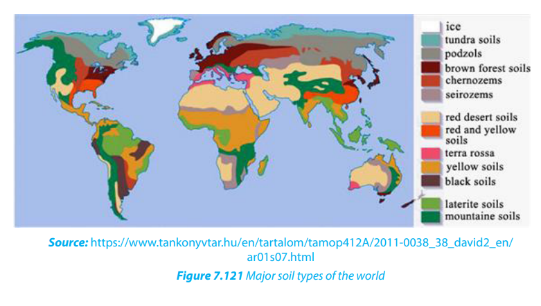
Make research on:
a. The major types of soils in the world.b. The difference between zonal soils, azonal soils and intrazonal soils.
7.2. Distribution of the major types of soil in the world
Learning activity 7.2.
Use the world map or Atlas to locate the distribution of major soil types.
Climate is an essential factor in soil formation. Therefore, the world’s major soil types
are distributed following the world’s climatic distribution.
7.2.1. Tropical soils
These include lateritic soils, red soils, black soils and deserts soils
• Lateritic soils: These are reddish brown soils that are developed under humid
tropical forest vegetation. These soils have granular dark reddish brown
surfaces underlain by reddish friable clay B-horizons. This type of soil is found
in regions with heavy rainfall where leaching is dominant throughout the year.
• Red soils: These are soils that develop in a warm temperate moist climate under
deciduous or mixed forests. They have thin organic mineral layers overlying
a yellowish-brown leached layer resting on a red horizon. They are found in
tropical areas where leaching takes place due to heavy rainfall.
• Black soils: These are found in humid tropical regions where the basalt rocks
are common.
• Desert soils: These are soils that develop under sparse shrub vegetation
in warm to cool arid climates. They have a light-colored surface soil, usually
underlain by calcareous material and a hard pan layer. They are found in both
arid and semi-arid regions. They are usually sandy and salty.
7.2.2. Temperate soils
i. Podzols: These are leached soils usually found in cool temperate regions.
ii. Chernozems: Chernozems also called black earth are found in extensive
temperate grasslands and contain a lot of humus.iii. Brown earth: These soils are found in temperate deciduous forested areas.
They are not leached.
7.2.3. Other soils
There are various types of soil whose characteristics are not determined by climate.
These occur in many regions. They include:
i. Mountains soils: These are stony and unstable soils in highlands. They are
usually eroded and transported to the lower valleys.
ii. Saline soils: They are found in areas where evaporation is dominant.
iii. Peat soils: They are found in water-logged areas. They contain dead
vegetation which is partially decomposed because of the lack of oxygen in
them.
iv. Limestone soils: They are common in limestone regions; when they are red
they are called “terra rossa”.
v. Alluvial soils: They are formed from deposited materials (sand, clay and silt)
along the river banks and lakeshores.
The following map shows the major types of soils of the world according to the
major climatic zones.
Application activity 7.2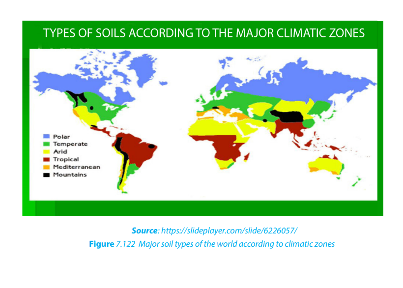
1. Use the above information from the map to describe the major types of
soils around your school
2. Draw a sketch map of the world and mark the major soil types
7. 3. Processes and factors of soil formation
Learning Activity 7.3.
Use internet and other geographical resources to research on the processes of
soil formation
7.3.1 Processes of soil formation
Numerous processes are involved in the formation of soil or pedogenesis and
the creation of the profiles, structures and other features described below by the
combined effect of physical, chemical, biological and other processes working on
soil parent material. Soil is said to be formed when organic matter has accumulated
and colloids are washed downward, leaving behind deposits of clay, humus, iron
oxide, carbonate, and gypsum, producing a distinct layer called the ‘B’ horizon.
i. Calcification: This is the process in which calcium carbonates accumulates
in the ‘B’ horizon; particularly characteristic of low rainfall areas such as arid
and semi-arid climates.
ii. Eluviation: Eluviation is the downwards movement of fines particles such
as clay and the leached soluble materials from upper layers of the soil (‘A’
horizon) to another lower layer within the soil.
iii. Illuviation: This is the process of accumulation of clay, aluminum and iron
usually from A and E horizons to B horizons.
iv. Mineralization: This is the process through which organic matter is further
decomposed into mineral compounds. Mineral content in humus may be
further converted to inorganic matter e.g. silica.
v. Humification: Humification is the process by which organic matter is
decomposed to form humus, a task performed by soil organisms.
vi. Weathering: Weathering is the process by which the rocks break down into
small particles to form soil. It is the combined action of physical weathering,
in which rocks are fractured and broken, and chemical weathering, in which
rock minerals are transformed to softer or more soluble forms.
vii. Leaching: Leaching is the removal of soluble material in solution. It is the
process by which water removes leached materials (organic and inorganic)
in solution from the upper horizon to the underlying horizon. It operates
vertically but not sideways.
viii. Laterization: Laterization is leaching of soils in warm and humid climates.
It is a process that occurs after the soluble mineral substances have been
leached. After leaching, the insoluble mineral compounds derived from theparent rock remain on top, hence forming lateritic soils that are stony.

7.3.2 Factors of the soil formation
Soil-forming factors are both passive (parent material, topography and time) and
dynamic (climate, living organisms and man’s activities). These factors work together
as a system to form soils.
The major factors that influence soil formation are shown below:
i. Climate
The moisture (rainfall), evaporation and temperature changes determine the
chemical reactions and physical breakdown of rocks. This results in soil profile
development.
ii. Relief or topography
Topography also affects soil formation. Slopes that are too steep cannot have full soil
development because gravity and erosional processes remove water and materials.
Flat areas encourage water percolation/infiltration which favors the development
of deep soil profile, whereas steep relief accelerates water surface runoff, hence a
shallow soil profile.
iii. The nature of parent rock
Physical and chemical weathering of rocks in the upper lithosphere provides theraw mineral ingredients for soil formation. These rocks supply the parent materials,
and their composition, texture, and chemical nature help determine the type of soil
that forms. A weathering of fine grained rock texture tends to form a shallow soil
profile, while dark colored rocks are easily weathered and form deep soil profile. Clay
minerals are the principal weathered by-products in soil.
Vegetation and the activities of animals and bacteria determine the organic content
of soil, along with all that is living in soil (algae, fungi, worms, and insects). The
chemical composition of the vegetation contributes to the acidity or alkalinity of
the soil solution. For example, broadleaf trees when decomposed tend to increase
alkalinity whereas needle-leaf trees tend to produce higher acidity. Also decay of
plants and animals supply the soil in humus and nutrients. Animals contribute to soil
development through breaking down of vegetation and rocks into small particles
that form the soil. The figure below represents the diversity of life in fertile soil thatcontributes to soil formation and recycling.
iv. Time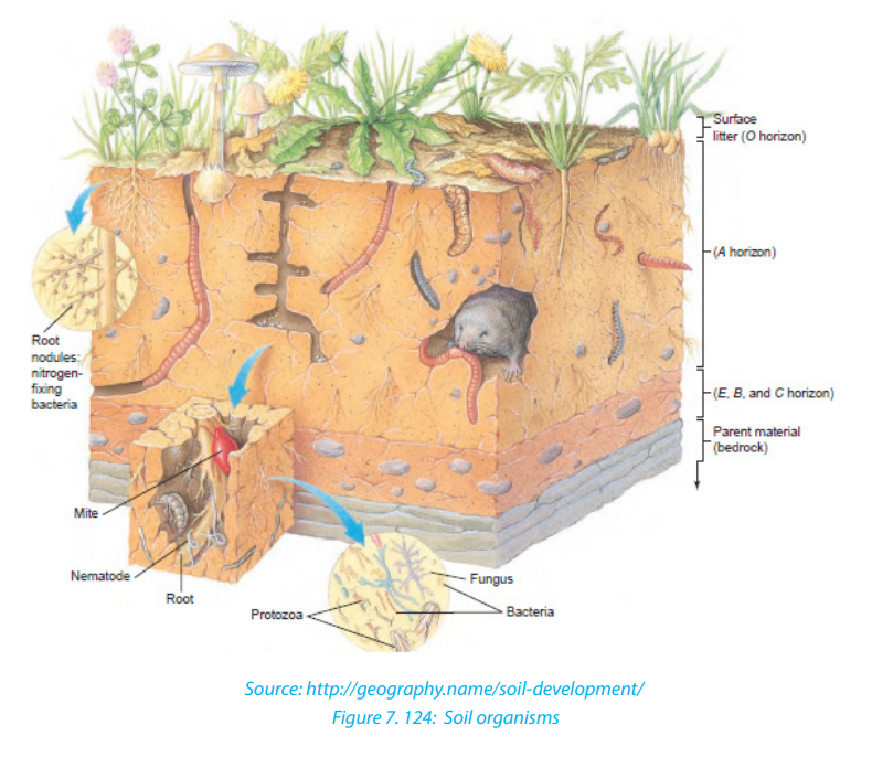
All of the identified natural factors in soil development (parent rock, climate,
biological activity, and topography) require time to operate. This determines the
depth of weathering and the period of operation of soil formation processes.
v. Human factor
Human activities have a major impact on soils. The use of fertilizers changes the
natural properties of soils. Soil erosion has greatly increased due to agriculture and
construction. Approximately 1.2 billion hectares (3.0 billion acres) of Earth’s soils
suffer degradation through erosion caused by human misuse. An example of soil
loss through sheet and gully erosion on a northwest Iowa farm One millimeter of soil
lost from an acre weighs about 5 tons. Planting on the contour prevents water fromflowing straight down the slope and thus reduces soil erosion.
Application activity 7.3:
1. Visit your local area and describe the soil formation processes in that area
2. Use the acquired knowledge from the above lesson and explain how
different factors, namely climate, living organisms, parent rock, relief, time
and man influence soil formation.
3. Which of the above processes (in 1 above) are the most predominant.Justify your answer.
7.4. Soil erosion

7.4.1. Causes of soil erosion
When vegetation is removed from soil, the soil is exposed to the direct action of
rain and wind. Rain and wind can erode the topsoil and carry it away, destroying the
soil’s structure. Also, without plants, soil development slows and sometimes stops
because humus is no longer being produced.
Soil erosion is the physical removal or washing away of soil by several agents such as
human activities (cultivation and building) and natural processes including running
water, strong winds, moving glaciers, animals. Soil erosion occurs when overlandflow moves soil particles downslope.
The causes of soil erosion are both man-made (human activities) and natural.
i. Man-made causes
a. Over-cultivation of the land
Ploughing disrupts the soil. Every year, the world population increases by 93 million
people and they need more food. Therefore, farmers plough more fields to produce
more food. This increases pressure on our soil resources. Ploughing soil is the
mechanical turning and loosening of soil to improve it for crops.
Soils have not always been managed effectively. Ploughing) soil removes the plant
cover that holds soil particles in places, leaving soils open to wind and water erosion.
This makes the land lose its fertility and becomes exhausted. Over cultivation is
usually caused by increasing population and scarcity of land for farming and food
production, and over-cultivation of available croplands.
b. Poor methods of farming
Growing of the same crops and constant ploughing of the land on steep slopes using
poor methods of farming also encourages soil erosion especially in highland areas.
c. Deforestation
Because of population increase, there is great pressure on forests in order to get
cultivable land and land for settlement. The high demand for fire wood and charcoal
both in rural and urban areas has posed a great threat on the natural forests. This has
led to wide scale deforestation hence severe soil erosion.
d. Bush burning
It is done in the dry season in nomadic areas, with the aim of improving the quality
of pasture which will grow during the next rainy season. This instead destroys the
soil cover, makes the soil exposed to all agents of erosion.
e. Rapid population increase
Today there is population explosion in most areas of the world especially in less
developed countries. There is massive human pressure on land, vegetation in search
of food, this leads to the removal of vegetation cover which accelerate soil erosion.
f. Overgrazing
It is a major cause of erosion in nomadic areas. It occurs as a result of overstocking
of domesticated animals like cattle, sheep and goats. The animals are too many for
the available land. They destroy all the grasses hence exposing the soil and thisaccelerates soil erosion especially water runoff and wind erosion.
ii. Natural causes
a. Heavy rainfall
This is common in hilly areas where the speed of surface run off is high than infiltration.
Rain drops take away the top soils to the valleys; e.g. North Western Rwanda.
b. Drought
The current climatic change has resulted into limited vegetation or no vegetation
cover. This make the soil to be exposed to the agents of erosion (wind and moving
water).
c. Winds
Wind takes away the top soil in areas with limited vegetation cover and trees which
would act as wind breakers. This is common in arid and semi-arid areas which
experience high temperature and too much sunshine.
d. River and wave action
Shorelines of lakes and oceans as well as banks of rivers are eroded by the waves
and running water respectively. This accelerates the rate of erosion.
e. Steep slopes
Steep slopes increase on the speed of surface run-off leading to high rate of soilerosion.
7.4.2. Areas of severe soil erosion
The following are areas of severe soil erosion:
i. Mountains and highlands with very steep slopes
Surface water runoff occurs whenever there is excess water on a slope that cannot
be absorbed into the soil or is trapped on the surface. Reduced infiltration due to
soil compaction, crusting or presence of steep slopes increases the runoff. Runoff
from agricultural land is greatest during rainy months when the soils are typicallysaturated.
The steep relief accelerates the rate of surface run off hence leading to soil erosion.
This is common in mountainous and hilly areas. Severe erosion occurs in these areas
because the speed of surface runoff is too high and takes away the top soil.
ii. Glaciated highlands
Moving ice and glacier on the major highlands carries away large quantities or
eroded soil in form of moraine. This is deposited at the base of mountain and on
outwash plains. Severe erosion by glaciers and melt water is common on most high
and steep glaciated mountains.
iii. Desert and semi-desert areas
Soil erosion, is severe in desert areas because of limited vegetation cover. Very
strong winds blow off the unconsolidated soil and detaches it from the ground. Soil
is relocated elsewhere by strong winds where it is carried and deposited in otherareas.
7.4.3. Effects of soil erosion
The following are the effects of soil erosion:
i. Limited mechanized agriculture
The use of modern machines like tractors is made difficult because of gullies which
affect their movement in farms, this in turn affect crop production.
ii. Destruction of crops
Soil erosion destroys crops on farmyards. The Wind erosion destroys the growing
crops especially in hilly areas and at times transport them to the lower valleys. This iscommon in the northern province of Rwanda.
iii. Low soil productivity
Soil erosion leads to the loss of soil nutrients which in turn affects the yields. The
bare soil in hilly slopes can no longer support crop production.
iv. Famine
Soil erosion leads to vegetation destruction and this affects rainfall formation. This
phenomenon limits agricultural productivity.
v. Change of the Landscape
It changes the landscape appearance and natural beauty of the areas affectedbecause of presence of landslides, gullies and rills.
vi. Siltation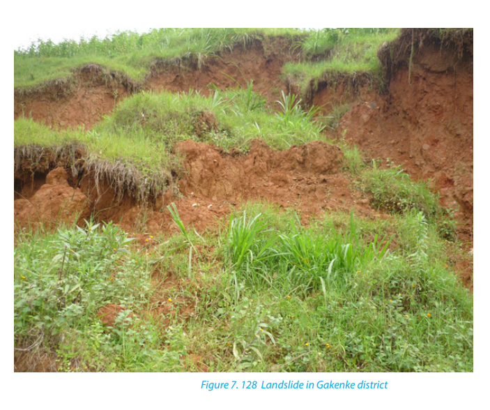
The eroded materials at times are deposited on people’s land or along river banks.
Such silt displaces people and destroys their property. This is common in flat lands
adjacent to hilly areas.
vii. Flooding
Floods cause great damages on communities and individuals. As most people are
well aware, the immediate impacts of flooding include loss of human life, damage
to property, destruction of crops, loss of livestock, and deterioration of healthconditions owing to waterborne diseases.
viii. Destruction of transport system
Roads are greatly destroyed because of soil erosion that results into gullies. These
gullies are caused by surface run off in the affected areas. This limits movement
of people, goods and services and requires urgent rehabilitation. This affectsgovernment’s budget.
Application activity 7.4.
1. Make a fieldwork study around your school and research on causes of soil
erosion and analyze their impact on the environment.
2. Basing on your experience on soils and topography, compare the effectsof severe soil erosion in the provinces of Rwanda.
7.5. Appropriate soil management and the conservation measures
The impact of soil loss on society is potentially disastrous as population and food
demands increase. The techniques described in the following paragraphs present
however some of management and soil conservation measures which enable
humans to use efficiently and sustainably the soil. They are presented and briefly
described as follows:
i. Agroforestry
This is a system of soil conservation where trees are planted around crops. Some
trees add nutrients to the soil while others protect crops from wind. This practice is
common in the northern province of Rwanda.
ii. Afforestation
It is a process of planting trees in a virgin land without any trees to create a forest.
Trees as windbreaks are planted and they reduce the speed of wind hence reducing
soil erosion. Therefore, afforestation is the creation of a new forest.
iii. Re-afforestation
It is the replanting of trees where they have been cut. This is usually done in steep
slopes where erosion is rampant. In several areas in Rwanda, this act has been done
under the system of countrywide tree planting. This has been done in order to
protect the environment and conserve soils.
iv. Contour ploughing
It is the farming practice of planting across a slope following its elevation contour
lines. These contour lines create a water break which reduces the formation of rills
and gullies during times of heavy water run-off; which is a major cause of soil erosion.
The water break also allows more time for the water to settle into the soil.
v. Crop rotation
It is a system of farming that involves growing of different types of crops in the same
area in sequenced seasons. It is done so that the soil of farms is not used for only one
set of nutrients. It helps in reducing soil erosion and increases soil fertility and crop
yields.
vi. Terracing
It is a piece of sloped plane that has been cut into a series of platforms, which
resemble steps, for the purposes of reducing erosion. This type of landscaping,
therefore, is called terracing. Terraces are commonly used on hilly or mountainous
terrain. Terraced fields decrease both erosion and surface runoff, and may be used
to support growing crops that require irrigation, such as rice.
vii. Use of fertilizers
It is important for farmers to use both artificial and organic fertilizers where necessary.
This improves the quality of the soils. Fertilizers help the soils to support vegetation
which plays a great role in protecting soils against erosion.
viii. Mulching
Mulching is the process of covering the top soil with plant material such as leaves,
grass, crop residues, straws etc. A mulch cover enhances the activity of soil organisms
such as earthworms and reduces the movement of soil. As the mulch material
decomposes, it increases the content of organic matter in the soil.
ix. Strip cropping
It is a method of farming which involves cultivating a field partitioned into long,
narrow strips which are alternated in a crop rotation system. It is used when a slope
is too steep or when there is no alternative method of preventing soil erosion.
x. Dry farming
This is also called Dry land Farming, the cultivation of crops without irrigation
in regions of limited moisture, typically less than 20 inches (50 centimeters) ofprecipitation annually.
Application activity 7.5.
Make a field study in your local area and analyze the appropriate measures taken
by the local community to conserve soil.
1. Discuss the role of community work (Umuganda) in conserving the soils
for sustainable development in your area.2. Study the illustration given below and answer the following questions:

7.6. Economic importance of soil
Soils are important to humans in various ways:
i. Agriculture
Soil has vital nutrients for plant growth. As a result, it is used in agriculture to nourish
plants. The roots of a plant receive nutrients from the soil to help plants grow.
ii. Building
Some soils provide important materials for building purposes. Soil can be used as
building materials such as sand and clay for, bricks, Tiles, block and concrete making.
Soil compaction increases the density of the soil and improves the load support
which is done as part of the building process.
iii. Pottery
Clay soil is used in making ceramics, or pottery. When water is added to clay soil, it
can be used to create the ceramics. Any type of ceramic can be created with the claysoil, such as vases, bowls, cups or other sculptures.
iv. Medicine
Some soil types are commonly used in the production of anti-biotics. Microbes
created in the soil are harmful to bacteria that is why soil is used in medicine.
Medicines created by soil include skin ointments, tuberculosis drugs and anti-tumor
drugs.
v. Mining industry
Some soils contain valuable minerals e.g. gold, diamond, etc. which helps in
industrial development.
vi. Habitat for animals
Some soils act as homes for various organisms like insects, worms, termites androdents and many others.
Application activity7.6
Using the above information on importance of soils, conduct a field work studyaround your school and investigate the impact of soils on the community.
End unit assessment
1. Deforestation in many parts of the world has resulted into severe soil
erosion and its associated effects.
a. Make a field study in your home area and evaluate the effects of soil erosion.
b. Identify other major causes of soil erosion in your area.
2. Most farmers in the northern province of Rwanda use terracing as a
measure of soil conservation.
a. Explain why terracing is mostly used in this area.
b. Describe other soil conservation techniques used in your area.
c. Show how these techniques are helpful to environmental sustainability.
3. Soil is a source of livelihood in the world because it is used in many ways.
Apart from agriculture, how can you use soil for your own survival in yourarea?
UNIT 8: CLIMATE CHANGE
UNIT 8: CLIMATE CHANGE
Key unit competence:
By the end of this unit, I should be able to discuss climate change and its impact on
Rwanda and other countries.
Introductory activity
1. Make a research on internet and other geographical materials to
establish a relationship between the following concepts:
i. Climate change
ii. Global warming
iii. Green house phenomena
iv. Desertification
2. Basing on the knowledge acquired in the first question assess the
consequences of climate change in Rwanda.
3. Which area of Rwanda is likely to experience the desertification? Givereasons supporting your answer.
8.1 Climate change: definition, causes and effects
8.1.1 Definition of climate change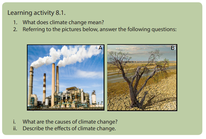
Climate change refers to the long-term changes in average conditions and
characteristics of earth’s lower surface atmosphere resulting either from natural
variability or human activities that change atmospheric conditions of a region
or location. It is also defined as a long term change of climatic elements such as
temperature, rainfall, wind speed and direction, sunshine, atmospheric humidity,
atmospheric pressure, cloud cover over a given region of earth’s lower surface
atmosphere or globally.
8.1.2. Causes of climate change
The causes of climate change are classified into natural causes and man - made
causes.
i. Natural causes of climate change
Natural causes of climate change include:
• Variations in the earth’s orbital characteristics
The more elliptical orbit makes the earth to be once year in closest position to the
sun (Perihelion: 147 500 000 km) or in farthest position to the sun (Aphelion: 152
500 000 km). At the Aphelion, the earth receives the least solar energy while the
maximum is received at the Perihelion.
i. Volcanic eruptions
Volcanic activity affects the climate. World temperatures are lowered after a series
of volcanic eruptions. This is due to the increase in dust particles in the lower
atmosphere which will absorb and scatter more of the incoming radiation. Sulphur
dioxide gas is given off during some of the eruptions. This gas remains in the
atmosphere for as long as three years and it reacts with water vapor and forms a
bright layer in atmosphere. This layer reduces the amount of solar radiation reaching
the earth surface by reflecting some back to universe.
• Variations in solar output
Sunspot activity which occurs in cycles, may significantly affect our climate. Times
of high annual temperatures on earth appear to correspond to periods of maximum
sunspot activity. The results found from satellites measurements showed a decrease
of 0.1% of the total solar energy coming to the earth in the early 1980s. This value was
obtained over a period of 18 months. It is predicted that the increase in solar output
of 1% per century will contribute to the increase of the global average temperatures
by between 0.50
C and 10C.
• Variation of aerosols in atmosphere
Aerosols like solid particles of varying sizes and liquid droplets which include:
ploughed soil cover, deserts, rocks, salt particles from seas and oceans; meteoric
particles, organic matter, such as bacteria, seeds, spores and pollen. These particles
help in selective scattering of shortwave electro-magnetic solar radiation which
adds varied color of red and orange at sunrise and sunset. Some of the aerosols,
mainly water droplets, absorb certain amount of solar radiation while some amount
of radiant solar energy is reflected back to the space. The high concentrations of
aerosols in atmosphere decrease the temperatures to reach the earth surface.
• Sunspots
Sunspots, defined as dark areas within photosphere of the sun and surrounded
by chromosphere, are created in the solar surface (photosphere) due to periodic
disturbances and explosions. These dark areas are cool areas because they are
characterized by 1, 5000C less temperature than remain part of photosphere. The
increase or decrease in number of sunspot is completed in a cycle of 11 years. It
is believed that the energy radiated from the sun increases when the number of
sunspots increases and consequently the amount of insolation received at the
earth’s surface also increases.
ii. Human causes of climate change
Human activities have been the mostly responsible for atmospheric alterations.
Human activities participate highly in atmospheric pollution leading to the change
in composition of atmosphere.
The atmosphere is polluted by human activities in the following ways:
• Variations of carbon dioxide in atmosphere
Carbon dioxide (CO2) is an important heat-trapping (greenhouse) gas. It is released
through human activities such as burning fossil fuels and gases released from
industries, as well as natural processes such as respiration and volcanic eruptions.
There is a positive relationship between the concentration of carbon dioxide in
atmosphere and the global temperatures: high concentrations of carbon dioxide
result to the rise of temperature on the earth surface while low concentrations of
carbon dioxide result to the lower temperatures.
• Forest and grassland fire
It increases the concentration of carbon dioxide in atmosphere resulting from the
burn of trees and grassland which are cut and put under fire for different purposes.
• Deforestation and land use changes
When people clear large areas of forests and grasslands for cooking or construction,
they reduce the main disposal system for carbon dioxide from atmosphere by
photosynthesis, which leading to the increase of carbon dioxide, and eventually to
the increase of temperature on the earth surface.
• Industrial developments
Gases like methane, nitrous oxide, chlorine, bromine and fluorine are added into the
atmosphere through industrial activities.
• Industrial waste and landfills
Industries which are involved in cement production, fertilizers, coal mining activities,
oil extraction produce harmful greenhouse gases. Also, landfills filled with garbage
produce carbon dioxide and methane gas contributing significantly to greenhouse
effect.
• Urbanization
The buildings of cities increase the reflection and decrease the absorption of solar
radiation which would change the temperatures on the earth surfaces. The urban
activities participate also in increasing the concentrations of greenhouse gases in
atmosphere leading to the rise in temperature.
• Increase in Population
It is obvious that the last two decades have experienced huge increase in the
population. Now, this has resulted in increased demand for food, cloth and shelter.
New manufacturing hubs have come up cities and towns that release some harmful
gases into the atmosphere which increases the greenhouse effect. So, more people
means more usage of fossil fuels which in turn has aggravated the problem.
• Farming
Nitrous oxide is one the greenhouse gas that is used in fertilizer and contributes to
greenhouse effect which in turn leads to global warming.
8.1.3 Effects of climate change
i. Effects of climate change in the world
The following are the effects of climate change in different parts of the world:
• Increase in the amount of rainfall: A rise in global temperatures could lead
to an increase of evapotranspiration. This could eventually lead to the rise in
amount of rainfall.
• Melting of glaciers: A rise of temperature leads to the melting of glaciers in
polar and mountainous regions resulting into flooding. This would cause the
levels of the sea to rise by 20 cm by the year 2030.
• Rise in the sea and ocean levels: The increase in the amount of rainfall and
melting of glaciers leads to the increase of the sea and ocean levels destroying
both human and physical features at the coast.
• Increases in intensity of extreme weather: Climate change increases events
such as heat waves, tornadoes and hurricanes.
• The prolonged severe droughts: Some regions may experience prolonged
droughts caused by reduction in rainfall, which may result in aridity.
• Depletion of ozone layer: High amount of harmful ultraviolet radiation
increases the cases of animal and human diseases such as cancers, blindness
and other eye diseases.
• Occurrence of acid rain: Acid rain is harmful to animal and human being.
• Lower crop and timber yields: Since ultraviolet radiation slows down many
aspects of plant growth such as photosynthesis and germination in many
plants leading to low production.
• Reduction of plankton growth: As temperature goes beyond coral reefs
living standard, fish breeding and feeding patterns are disrupted.
• Decrease of agricultural production: In some regions, the rainfall may
decrease, or agriculture seasons be disrupted because of climate change.
Some regions became drier and make soil infertile for crop production.
• City environments becoming warmer: The increase of carbon dioxide makes
the temperatures to increase most in urban areas.
• Water use and long-term planning: A wetter or drier climate can affect water
resources planning. Water reservoirs, dams, and hydroelectric projects might
become useless in coming years.
• Spread of vector-borne diseases: Because of high temperature there can be
an increased range of insects.
• Acidification of oceans: This can create a reduction in plankton, coral reefs
and a drop-in fishing yield.
ii. Effects of climate change in Africa
The following are some of the facts showing the climate change and variability in
Africa:
• Melting of glaciers on the top of the highest African mountains such as
Kilimanjaro, Rwenzori, Mount Kenya, and Kalisimbi.
• Warming in African tropical forests has been evaluated at 0.29 °C for the past
10 years and 0.1 °C to 0.3 °C in South Africa, while it ranged between 0.2 °C and
0.3 °C in the Nile Basin countries.
• Decreasing trends in temperatures; in eastern Africa, the situation has been
complex because they have been observed over the regions close to the coast
or major inland lakes and increasing in the rest of the region.
• The gradual heating, between 1961 and 2000, over the continent meant more
warm spells (days) and fewer cold days across Africa. An increase in temperature
in Sahara desert has led to the decline in volume of water in Lake Chad.
• Fluctuations of precipitation; the extent of variability is complicated and
exhibits more spatial and temporal fluctuations across the continent
The decrease in rainfall has been registered in West Africa (between 4 ° and 20
°North; 20 °West and 40 °East), by up to 20% to 40% for the periods 1931-1960
and 1968-1990 respectively. A similar decline in mean annual rainfall has also
been observed in the tropical rain-forest zone. A reduction of around 4% in
West Africa, 3% in North Congo and 2% in South Congo for the period 1960-
1998.
• Increases in rainfall have been registered in different parts of southern Africa
(e.g., Angola, Namibia, Mozambique, Malawi, and Zambia)
• Increase in the desertification in south of the Sahara desert.
• Links have also been identified between the warm Mediterranean Sea and
abundant rain fall over the surrounding regions.
iii. Effects of climate change in Rwanda
Rwanda experiences some rainfall events that cause unexpected flooding and
catastrophic events such as landslides etc. These extreme events are attributed to
climate change. The figure below represents some effects of extreme rainfall eventsof climate change in Rwanda.
The following are effects of climate change in Rwanda: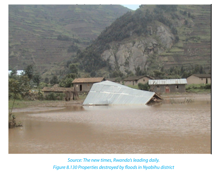
• Significant increase in precipitation at a rate of between 2 and 6.5 mm per
year over the Congo-Nile crest and the northern highlands for the period of
1935–1992.
• Floods that occurred in May 2002 caused the death of 108 persons in North
western regions while the one occurred in 2007 have resulted to displacement
of more than 456 families and destruction of hundreds of hectares of crops in
Bigogwe sector in Nyabihu District.
• During September 2008 heavy rainfall accompanied by winds affected 8 of the
12 sectors of Rubavu district and provoked the displacement of more than 500
families, caused the destruction of about 2,000 hectares of crops and many
other infrastructures.
• Floods reported in September 2012 in Nyabihu, Rubavu, Bugesera and Kirehe
districts whereby more than 1000 families were displaced and their crops
submerged completely.
• The landslides and floods caused by heavy rainfall are regulary observed mainly
in north- western parts of Rwanda (Rulindo, Gakenke, Musanze, Nyabihu and
Rubavu districts). For instance, the floods which occurred on 2nd and 3rd April,
2016 caused the death of 12 people, with 19 injured and destruction of 196
houses across the country. The floods which took place in Musanze district
on 20th April 2016, caused the destruction of 64 houses and many hectares of
crops and cattle.
• The significant increase in mean annual temperatures of between 0.036 and
0.066 °C per year for the period of 1961-1991.
• Since 1902, a number of famines following prolonged droughts episodes have
been registered in Rwanda notably in eastern and south-eastern regions.
• More occurrences of lightning combined with the thunderstorms in 2013
caused 12 deaths in Karongi, 12 in Rubavu, 4 in Rusizi and 5 death Rutsiro
districts, respectively. The same districts suffered from the same extremeweather events which were reported to cause 15 deaths in 2015 (JanuaryOctober) with 30 people injured.
Application activity 8.1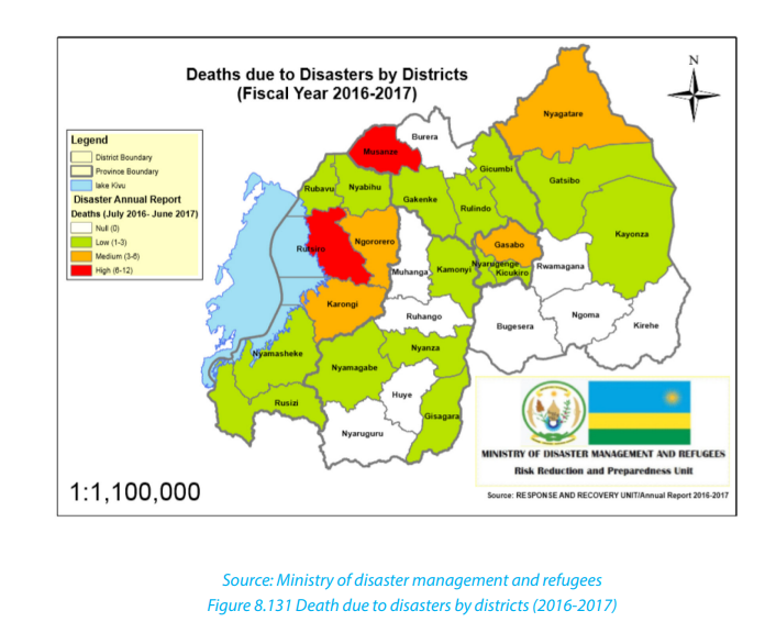
1. Explain the common effects of climate that are observable worldwide
and in Rwanda.
2. Identify the areas of Africa that are susceptible to face the climate change
challenges?
3. Describe the effects of climate change in Eastern and Western provinces ofRwanda.
8.2. Global warming and green house phenomena
8.2.1. Definitions of global warming and greenhouse phenomena
These two phenomena of global warming and greenhouse are related but are
different.
• Global warming
Global warming refers to the gradual rise in world temperatures. This is a gradual
increase in the average temperature of the earth›s atmosphere and oceans due to
increase in the amount of carbon dioxide. The increase in the amount of carbon
dioxide leads to greenhouse effect. It is a change that is believed to be permanently
changing the earth’s climate. An increase in greenhouse gases increases the
greenhouse effect which in turn increases the global warming. In the last 100 years,
the mean surface temperature on earth has increased by 0.5 °C.
• Greenhouse effect
The greenhouse effect is a phenomenon in which the atmosphere of a planet traps
radiation emitted by sun. It is caused by gases such as carbon dioxide, water vapor,
and methane that allow incoming solar radiation to pass through but retain heatradiated back from the planet’s surface.
8.2.2 Causes of global warming and green house phenomena
The following are the causes of global warming and green house phenomena:
1. Human factors
Human activities produce various gases ejected in the atmosphere that are
responsible for the global warming. These activities are destroying earth at fast
rate. The emission of carbon dioxide from industries and vehicles, the burning
of fossil fuels, cutting of trees and forests to build some new buildings and new
malls, dumping of trash everywhere and not even recycling it, excessive use of the
plastics and smoke from factories. All the activities performed by human beings are
the major factors for gases that pollute the air and warm up the earth. These may
contribute to the destruction of the ecological balance of the nature leading to the
global warming.
i. Burning of fossil fuels
Fossil fuels are burnt on day-to-day basis. This activity produces large percentage
of gases such as carbon, petroleum, coal and many other different gases which are
emitted in earth’s atmosphere. Carbon dioxide being one of gases with greenhouse
effect is provided in excess in our atmosphere in far greater quantity in comparison
with other gases produced by human activities.
ii. Use of chemical fertilizers
The use of the artificial chemicals for crops has become one reason for the global
warming. These chemicals are dangerous to the earth as well as to the human beings.
These fertilizers are rich in the nitrogen oxide which is more dangerous than
the carbon dioxide. These oxides of the nitrogen destroy ozone layer even faster
than other greenhouse gas and hence lets harmful ultraviolet rays enter atmosphere
thus making earth warm and leading to the global warming.
iii. Industrial advancement
More and more different industries and factories are set up in modern world to
meet needs of the human beings. These factories need large amount of fuels like
some coal, petroleum for power generation and electricity required by machines
to work. Burning of these fuels also releases large amount of the carbon dioxide
which absorbs harmful radiations from sun making it warm, hence increasing global
warming.
iv. Deforestation
The mass removal of trees, called deforestation, also affects the amount of carbon
dioxide in our atmosphere. Forests around the world are being cleared for cultivation,
mining, building, roads building, grazing cattle, etc. As they grow, trees take in carbon
dioxide. When trees are removed, the carbon dioxide that they could have removed
from the atmosphere is left. Cut-down trees are often burned. Burning produces
more carbon dioxide. If the trees are cut, plants will not be able to produce oxygen
and concentration of the carbon dioxide will increase. Increase of the carbon dioxide
in air is very harmful for the human beings and also disturbs water cycle and hence
total imbalance of our ecosystem. So being one of greenhouse gases it will lead to
the global warming.
v. Air pollution
The harmful gases emitted from vehicles and the factories and greenhouse gases
cause some pollution in the air and these gases get captured in atmosphere. The
smoke gather up in atmosphere forming some clouds full of harmful gases which
later fall as the acid rain which destroys plants. Plants provide us with oxygen and
if they die level of carbon dioxide will increase in atmosphere which is known as a
harmful gas. These gases emit heat which increases temperature of earth, hence
causing global warming.
2. Physical factors
i. Volcanic eruptions
Volcanic eruptions are also among the causes of global warming. These eruptions
contain the dust particles and gases like the sulfur dioxide which stays in the
atmosphere for years and blocks the sunlight from reaching surface of earth making
it somewhat cool. These dust particles affect balance of atmosphere and becomes
contributing factor of the global warming.
ii. Depletion of ozone layer
Depletion of ozone layers is an important factor that causes of global warming. The
ozone layer is known as the layer outside the atmosphere which protects surface
of the earth from harmful ultra-violet and the infrared radiations causing some
dangerous diseases like the skin cancer. Ozone layer depletion is one of causes of
the global warming; entering of the harmful gases which helps in heating up the
earth but other greenhouse gases like the carbon dioxide and methane that helps
in heating up and tears up ozone layer making a hole called “Ozone hole”. So, ozone
layer depletes due to these gases which allow ultra violet radiations to enter the
earth’s atmosphere making it more warm than normal and also affects temperature
leading to the global warming.
iii. Impact of greenhouse process on global warming
Greenhouse effect is a process in which the atmosphere of the earth traps some of
the heat coming from the sun and fails to radiate, making earth warming. This is due
to the burning fuels, cutting of trees, concentration of the heat on earth is increased
to some abnormal levels making the greenhouse effect as one of the major causes of
the global warming. Carbon dioxide, nitrous oxide and methane are the greenhouse
gases which help to keep earth warm. It is natural phenomenon that takes place
with adequate concentrations of some greenhouse gases. When concentration of
these gases rises then they disturb climatic conditions, thus making earth warmer.
These gases are not able to escape and that causes the worldwide increase in
temperatures. So balance of the carbon dioxide and some other gases should be
maintained so that it does not become major reason for the global warming.
8.2.3. Effects of global warming and green house phenomena
Effects of global warming and green house phenomena are multiple. Only the most
important are briefly presented below:
i. Increase in temperature
The intense heat waves and rising temperatures are becoming more common as
greenhouse gases are trapped in the atmosphere. The energy from the sun which is
responsible for the earth’s weather and climate is radiated back into space. While this
happens the greenhouse gases (water vapour, carbon dioxide, and other gases) trap
some of the outgoing energy and retaining the heat. The greenhouse effect thus
leads to a rise in temperature on, and as it becomes stronger, more heat is trapped
within the planet.
ii. Melting of ice and rising sea levels
Warm surface temperatures cause glaciers, polar ice shelves and other ice bodies to
completely destabilize and melt. This in turn increases the amount of water in the
world’s oceans thus contributing to a rise in sea levels. Consequently,
some low-lying areas experience increased flooding.
iii. Extinction of some animal species
Warming temperature of water bodies, desertification and deforestation can
all contribute to the irreversible impact on natural habitat and thus threaten
endangerment and even extinction of some plants and animals. As an example; the
polar bear is considered to be an endangered species whose numbers are falling
because of their inability to adapt to the volatile temperature changes in the Polar
Regions.
iv. Migration of animals
All animals live in regions with extremely specific climate and geological conditions,
such as temperature and rainfall patterns, that enable them to survive and reproduce.
Any change in the climate of the specific habitat can affect the animals that exist
there, as well as the overall makeup of the environment. Some species respond to
warmer climatic conditions by migrating to cooler locations. For example, some
North American animals have moved to the farther north of the region or to higher
elevations to meet their requirements.
v. Effects on human health
Changes in weather conditions can lead to health conditions ranging
from heat related heart and respiratory problems to malaria. Droughts, floods and warmer
temperatures combine in order to create an apt habitat for insects and creatures
such as mosquitoes and other disease-carrying agents which causes dangerous
diseases and sometimes leading to the death.
vi. Storms
The phenomenon of global warming is bound to increase the degree of severity in
terms of storms. Warmer temperatures and warmer ocean waters would increase the
intensity of these storms thus leading to a high number of devastating hurricanes.
On observing the pattern of storms in the past decade it can be noted that the
frequency has literally doubled. Along with floods comes loss of lives, damage to
property, resources.
vii. The failure of ecosystem
An increase in greenhouse gases can cause drastic and irreversible changes both
in the upper atmosphere and within the planet thus affecting its every component
including land, water, air, plants and the processes that occur at all these levels. If not
becoming extinct, animals and plants move away to non-native habitats when the
very ecosystems that they were adapted to for survival lose its quality or probably
even disappear.
viii. Economic collapse
The results of climate change have a direct relationship with a nation’s economy.
Natural disasters such as hurricanes and floods as an effect of the global warming
process end up becoming a costly affair for the government in terms of clean-up
costs, property damage and rehabilitation costs.
ix. Droughts
A warmer climate owing to global warming will eventually lead to diminishing
water supplies and pathetic agricultural conditions in turn resulting in crop failures.
If these water shortages are persistent it will cause a lot of disruptions in global food
production by affecting agriculture and is thus causing starvation.
x. Occurrence of wars
Hostilities and conflicts amongst countries are constantly on the rise as nations
are competing and ruthless when it comes to acquiring resources. An important
example of this is the conflict in the Darfur region situated in Sudan or the Somalian
war with roots in the reduction of its natural resources due to the sole reasons of
climate change. It is clear that the increasing number of wars that commence on
the foundation of food and water scarcities may lead to uncontrollable levels ofaggression, insecurity and regional instability.
Application activity 8.2
1. Explain why causes of climate change and green house differ in rural and
urban areas.
2. Among the effects of climate mentioned above, which ones do you
observe in your local environment?
3. Referring to the greenhouse phenomenon, describe the advantages and
disadvantages of the farming practiced in greenhouse
8.3 Adaptation and mitigation measures for climate change
Learning activity 8.3
In your local environment, identify any evidence of climate change and propose
sustainable strategies to deal with it.
8.3.1 Adaptation measures for the climate change
Adaptation for climate change refers to measures and strategies taken to cope with
climate change and variability. These measures vary from one domain to the other
like agriculture, livestock keeping, tourism, public health and water management;
from one climatic region to the other as dry, wet, hilly, flat, depression, mountains,
floodplains; from season to season as in dry and wet seasons; and across diverse
actors as private, public, national, international, NGOs, local communities. Hence,
adaptation measures are many and are not homogeneous.
The following are some of them:
• Maintaining current ecosystems wherever possible: This implies
strengthening, extending and in some cases refining global protected area
networks to focus on maintaining large blocks of intact habitat with a particular
emphasis on climate change.
• Agro-forestry: This is a land-use system that incorporates trees in food crop
fields. In other words, it is a combination of agriculture and forestry for more
diverse, profitable, productive and sustainable land use.
• Progressive and radical terracing: This is used to reduce runoff, soil erosion
and landslides. At the same time, terracing helps to improve soil quality and
moisture retention, especially in steep areas.
• Soil fertility conservation: Practices like the use of manure, mulching,
planting of leguminous crops help to improve soil fertility by increasing the
micro-organism composition in the soil.
• Seed and grain storage: This involves collecting seeds and grains from
farmers at post-harvesting season and releasing them within the timely agreed
periods.
• The use of pesticides: It is a wide range use of compounds such as insecticides,
fungicides, herbicides, rodenticides, molluscicides, nematicides, plant growth
regulators and others to control pests, insects, fungi, weeds, bacteria, rodents,
all of which are harmful to crops.
• Ecological pest management: This is the use of natural enemy dynamics
or environmental positioning (e.g. crop shading) to eliminate or reduce the
presence of pests.
• The use of improved seeds and species: This is vital to improve crop
productivity.
• Crop varieties and diversification: This consist of integration of different
varieties of crops and hybrids of a particular crop. Multiple cropping aids in
replenishing the soil and maintaining its fertility by ensuring that there is a
constant balance of nutrients by decreasing dependence and saturation of
any one product.
• Land use consolidation programmes: This encourage farmers with adjacent
lands to grow the same crop. This facilitates the provision of inputs (e.g. seeds
and fertilizers), post-harvest activities (e.g. driers, seed and grain storage
facilities) and safer and faster transport of agricultural products.
• Rain water harvesting: It is the practice of collecting and storing rainwater
from rooftops, land surfaces or rock catchment areas for different use.
• Irrigation like drip irrigation is a practice based on the constant application
of specific and controlled quantity of water to the crops. The system uses pipes,
valves and small drippers or emitters that transport water from the sources
(i.e. wells, tanks and reservoirs) to the root area and applying it in controlled
quantities and pressure specifications, while Sprinkler irrigation involves
spraying the crops with water using sprinklers in a manner that resembles
rainfall.
• Wastewater use: It forms a reliable source for crop irrigation and a positive way
to dispose of sewage water. Whereas wastewater contains a lot of nutrients on
the one hand, it carries pollutants like micro and macro organic and inorganic
matters that potentially pose hazards to human health, the environment,
crops and soils, on the other.
• Biotechnology of crops: It involves the practical application of biological
organisms, or their sub-cellular components in agriculture and livestock. The
techniques currently in use include tissue culture, conventional breeding,
molecular marker-assisted breeding and genetic engineering.
• Barrier crops: These are crops that are used as a cultural control strategy
for reducing the spread of pests and diseases to the most vulnerable crops.
These crops provide benefits over “hard infrastructure” in a number of ways:
first, they offer a natural form of protection; second, they contribute to the
biodiversity and often soil improvement; third, they can provide an added
source of food provisions or income and, finally; they can play a determinant
role in soil erosion reduction.
• Integration of meteorological information in agriculture: It is used to
develop early warning systems, crop monitoring and disaster management.
• Training farmers: By offering short courses, seminars and group discussions
on the impacts of climate changes and on various ways of adaptation.
• Facilitating the farmers: By facilitating farmers to access capital that they
need to purchase seeds, installation of tube wells, drilling of pumping sets,
chemical fertilizers, plant protection chemicals, tractors, harvesters, threshers
and other accessories.
• Development of infrastructure: This concerns the improvement of transport
networks, electricity and marketing facilities which use to be affected by
climate change phenomena to promote a sustainable livelihood of population.
• Development of agricultural institutions: The institutions such as universities
provide experts and researchers who offer critical services like assessment,
promotion of agricultural and livestock innovations and dissemination of
research findings to agronomists and farmers at all levels.
8.3.2 Mitigation measures for climate change
Mitigation measures for climate change consist of actions to limit the magnitude
and or the rate of long-term climate change. Climate change mitigation generally
involves reductions in human (anthropogenic) emissions of greenhouse gases.
Anthropogenic greenhouse gases include carbon dioxide (CO2), methane (CH4),
Nitrous oxide (N2O) and a group of gases referred to as halocarbons.
The following are mitigation measures for climate change
• Storing and reducing carbon dioxide: Carbon dioxide can be captured and
stored, but also it can be reduced. Carbon dioxide Capture and Storage (CCS)
is a process consisting of the separation of CO2 from industrial and energy
related sources, transport to a storage location and long-term isolation from
the atmosphere. Conserving electricity is one strategy to reduce CO2. When we
conserve electricity, we reduce the amount of fossil fuel that must be burnt.
One way to save fuel is to change daily activities that rely on energy from
burning fuel.
• Use of energy that reduce the atmospheric pollution: The use of renewable
energy supply technologies, particularly solar, wind, geothermal and biomass
are recommended to reduce the atmospheric pollution. Renewable energy
systems such as hydro-electricity can contribute as well to the security of
energy supply and protection of the environment.
• Reduction of the energy use in buildings: Cooling energy use in buildings
can be reduced by different measures, for example reducing the cooling load
by building shape and orientation. Reducing this energy means, in the case of
using water for cooling, lower water demand.
• Land-use management: Forest land, cropland, grassland, wetlands,
settlements have to be well managed by fighting against any threaten to
them. Changes in land use may result in net changes in carbon stocks and in
different impacts on water resources.
• Cropland management: The use of agricultural practices which promote
the conservation of water, and its quality. There is a need for improved crop
and grazing land management to increase soil carbon storage; restoration of
cultivated peaty soils and degraded lands.
• Afforestation and reforestation: The increase of number of trees helps to
capture the CO2 and decreases the flow of water from catchments.
• Solid waste management and waste water treatment: Controlled landfill
(with or without gas recovery and utilization) controls and reduces greenhouse
gas (GHG) emissions but may have negative impacts on water quality in thecase of improperly managed sites.
Application activity 8.3
1. If you were the Director General of REMA, demonstrate the adaption
measures to climate change in Rwanda.
2. Suppose that you are a manager of a big industrial complex, describe the
strategies to mitigate climate change.
3. Explain the process by which the use of refrigerator contributes to climatechange.
8.4 Climate change and desertification

8.4.1. Definition of desertification
Generally, desertification is described as the turning of the land into desert. It is
the process by which the land undergoes degradation from which a relatively dry
land region becomes increasingly arid, typically losing its bodies of water as well
as vegetation and wildlife. Desertification is caused by a variety of physical factors,
mainly the climate change and human activities.
8.4.2. Causes of desertification
Desertification is caused by a combination of factors that change over time and vary
by location. These include the following:
• Less rainfall (total amount) and increased drought (frequency and intensity).
As a consequence, rivers and water bodies might dry up leading to the decrease
of protective vegetation cove.
• Global warming: It causes higher temperatures and increased
evapotranspiration. This reduces condensation and leads to shortage of
rainfall.
• Population growth: The effect of this is the over-cultivation which reduces
soil fertility and leaves the soil exposed to erosion.
• Deforestation: An increased demand for cultivation land, wood for cooking,
heating, building, increases the risk of soil erosion.
• Poor crop cultivation practices: Some farmers do not know how to use the
land efficiently. Farmers may essentially strip the land of everything that it has
before moving on to another plot of land. By stripping the soil of its nutrients,
desertification becomes more and more of a reality for the area that is being
used for farming.
• Urbanization and other types of land development: Development can
cause people to go through and kill the plant life. It can also cause issues with
the soil due to chemicals and other things that may harm the ground. As areas
become more urbanized, there are less places for plants to grow. This can
contribute to the process of desertification.
• Soil erosion: the losses of the top soils and vegetation leads to the
desertification.
• Climate Change: Climate change plays an important role in desertification.
As the days get warmer and periods of drought become more frequent,
desertification becomes more and more eminent. Unless climate change is
slowed down, huge areas of land will become desert; some of those areas may
even become uninhabitable as time goes on.
• Over exploitation of the land of resources: If an area of land has natural
resources like, oil, or minerals, people will come in and mine it or take it out.
The removal of resources is usually associated with the striping of the soil and
Geography Senior Six Student Book 217
depletion of nutrients. Consequently, plants are died and from there starts the
process toward becoming a desert biome as time goes on.
• Natural disasters: There are some cases where the land gets damaged because
of natural disasters, such as natural fires, drought, floods, and earthquakes.
• Rise of salinity: In the soil which cause the vegetation to be stunted.
• Overgrazing: If there are too many animals that are overgrazing in certain
spots, it is difficult for the plants to grow back. Biomes are affected and lose their original vegetation.
8.4.3 Effects of desertification
The following are the major effects of desertification:
• Farming becomes unproductive: If an area becomes a desert, it’s almost
impossible to grow substantial crops there without special technologies. This
can cost a lot of money to try and do so as many farmers will have to sell their
land and leave the desert areas.
• Hunger (famine): Without farms in these areas, the food that those farms
produce will become much scarcer. The people who live in those local areas
will be a lot more likely to try and deal with hunger problems. Animals will also
go hungry due to food shortage.
• Flooding: Without the plant life in an area, flooding is much more eminent.
Some huge rivers cross deserts which experience a lot of flooding because
there is nothing to stop the water from gathering and going all over the place.
• Poor water quality: If an area becomes a desert, the water quality is going
to become a lot worse than it would have been otherwise. This is because the
plant life plays a significant role in keeping the water clean and clear.
• Overpopulation of the new areas: When areas start to become desert,
animals and people will go to other areas where they can actually thrive. This
causes overcrowding and overpopulation, which will, in the long run, end up
continuing the cycle of desertification that started this whole thing anyway.
• Poverty: All of the issues that are described above (related to the problems of
desertification) can lead to poverty if it is not kept in control. Without food and
water, it becomes harder for people to thrive, and they take a lot of time to try
and get the things that they need for their subsistence.
• Acceleration of desertification: The increased frequency and severity of
droughts resulting from projected climate change is likely to further accelerate
desertification.
• Involuntary migration: Rural population affected by the effects of climate
change, especially the drought or aridity migrate towards different areas. This
may also lead to rural exodus.
• Shortage of drinking water and water to use for other purposes: This is
where overpopulation causes pressure to exploit drylands for farming. These
marginally productive regions are overgrazed, the land is exhausted, andgroundwater is over drafted.
Application activity 8.4.
1. Observe the picture below showing the drought that happened in a dryarea in Rwanda and answer the questions that follow:
i. Referring to the factors of desertification discussed above, describe the
causes of the above phenomenon.
ii. Explain the effects of such phenomenon to the people living in such area.
iii. Considering the physical conditions of Rwanda, suggest the districts in
which the above phenomenon is likely to happen and the strategies to 0782234624limit this problem.
End unit assessment
1. Compare the factors that can cause the climate change in China and
Rwanda.
2. Explain the causes of climate change in developed and developing
countries.
3. The World needs to develop at high rate with its industrialization
processes which is among the most causes of greenhouse effects. Suggest
the mitigation measures for climate change in this regard.
4. The world is facing the problem of climate change and this is substantially
leading to the problem of desertification. Indicate the most affected
areas by that problem? Suggest the sustainable strategies to address theproblem of desertification.
UNIT 9 GLOBAL DRAINAGE SYSTEMS
UNIT 9: GLOBAL DRAINAGE SYSTEMS
Key unit competence:
By the end of this unit, I should be able to investigate the economic importance of
global drainage systems and the reasons for their conservation
Introductory activity
1. Do research using the internet and other geographical resources to
explain the following drainage terms:
a. Drainage system, a river and associated terms like river discharge, river
velocity, catchment area, a river divide and a river basin.
b. How does a river erode, transport and deposit its load?
2. Referring to the nearest river or Lake in your local environment or near
your school explain the usefulness of drainage systems.3. Discuss why there is need to conserve drainage systems.
9.1. River system
Learning activity 9.1
1. Do research and explain the types of rivers and the river profiles.
2. What do you understand by the concept of a river profile?
9.1.1. Definition of a river and the associated terms
A river is a natural wide flow of water across the land. The water originates from a
known source and empties into a sea, lake or another river. The river flows along a
channel, whose water volumes increases as the river goes downstream.
The following terms are used in describing a river channel
• Discharge: is the amount of water originating from precipitation which
reaches the channel by surface runoff, through flow and base flow. Discharge
is, therefore, the water not stored in the drainage basin by interception, as
surface storage, surface moisture storage or groundwater storage or lost
through the evapotranspiration.
• River Velocity: Is the speed at which the water flows through the channel. It is
less at the sides and bed than at the center of a river. The velocity also depends
on the river’s gradient.
• A river Basin: Is an area of land drained by a river and its tributaries. Its
boundary is marked by a ridge of high land beyond which any precipitation
will drain into adjacent basins. This boundary is called a watershed.
• A river divide: This is the crest of the upland or mountain from which the
streams flow down the slopes on both sides to their journey.
• River width: This is the distance across the surface of a river from one bank to
another bank.
• River depth: Is the vertical distance from the river surface down to its bed.
• River gradient or slope: Is the angle of slope between the vertical drop in
relation to the horizontal distance of a river.
• Catchment area: A river catchment is an area from which a river derives its
water. This can be an upland or mountain.
9.1.2 Types of rivers
There are different types of rivers. The following are the main types:
• Perennial River: This is a river with water flowing permanently in its channel
throughout the year.
• Intermittent River: This is a semi-permanent river which stops flowing at some
point in space and time. It stops to flow every year or at least twice every five
years.
• Ephemeral River: This is a seasonal river that flows only when there is heavy
rain or when snow has melted.
9.1.3 The river system: The work of a river
As a river moves from its source to its mouth, it performs the triple function (three
phases) of erosion, transportation and deposition. The following is the work of a
river:
a. River erosion: This involves the removal of different soils and rock particles
of varying sizes from the river’s bed and banks. Erosional work of rivers
depends on the channel gradient, the volume of water, the river’s velocity,
water discharge and the sediment load (amount of eroded material). The
river erosion is at its peak when the river passes through a steep gradient
where the speed of flow is great. The river erodes its bed and channel in the
following ways:
• Hydraulic action: This is the process by which fast flowing water enter into the
cracks on the river bed and channel sides. The repeated friction and pressure
of water force cracks to widen and finally erode weaker rocks.
• Solution or corrosion: This is the removal of rocks like salt, limestone etc. that
are soluble in water. Such rocks dissolve in water and are carried in solution
form.
• Abrasion or corrasion: This is the erosion of the river’s bed and channel sides
by the rolling action of materials or river load against rocks. The heavier rocks
transported in water rub and slid against the bed and channel rocks eroding
them as they are transported downstream.
• Attrition: This is the erosion of the river’s load by the load itself. The rock
particles carried by a river collide against each other and break into smaller
particles.
b. River transportation: Rivers transport refers to the carrying away of eroded
material downstream. Rivers transport their load in the following ways:
• Solution: This is the downstream movements of soluble material like salt,
carbonates dissolved in water.
• Suspension: This is where the light particles of plants, soil and rocks are carried
away while floating or maintained within the turbulence flow of water.
• Saltation: This occurs when the load carried by the river is transported in a
series of short jumps or hops. It involves the transportation of particles which
are not too heavy but cannot remain suspended in water. Materials such as
pebbles, sand and gravel are temporarily lifted up by the river currents and
then dropped back along the bed in a hopping motion. Such movements are
known as hydraulic lift.
• Traction: This is where large and heavy materials are rolled, pushed and
dragged downstream by the force of moving water. Such materials include
rocks, pebbles and boulders.
c. River deposition: This refers to the situation where a river fails to transport
its load. The river, then drops its load due to the reduction in its energy. The
heavy load is selectively deposited first, while the fine and lighter particles
are deposited last. The material deposited by a river is referred to as alluvium.
9.1.4: The river profile and its characteristics
A river profile is a section through the river channel from its source to its mouth or
from one bank to another. There are two types of river profile: cross profile and long
profile.
• Cross profile
This is also known as the transverse section of a river. It is the shape a river assumes
from one river bank to the other. It develops as a result of down-cutting and lateral
cutting of the riverbed and banks by water currents. This undercutting makes a
section of a river valley, have different shapes and forms. For example, in the upper
valley, vertical erosion produces a steep “V”-shaped valley. However, this depends
on the rate of erosion and weathering taking place on the valley sides.
In the middle and lower stages, the river valley begins to become shallow and widedue to increased lateral erosion. The valley assumes a “U” shape.
• Long profile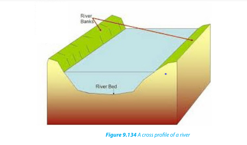
This is the longitudinal section of a river. It contains a variety of erosional and
depositional features. Based on its distinctive characteristics, the long profile of a
river is divided into three stages (upper/youthful, middle/mature and lower/oldstages) known also as normal cycle of erosion.
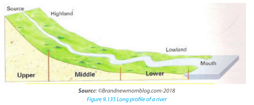
The following are the characteristic features of successive stages:
• Youthful stage: This is also known as the torrent or upper stage of a river.
- The gradient at this stage is steep. Therefore, the river flows very fast.
- The main river gradually deepens its valleys.
- The main type of erosion is vertical. The valleys are narrow and deep.
- The features found in this stage include gorges, rapids and waterfalls. .
• Mature stage: it is also known as the valley stage or the middle course.
- This is the stage between the upper and lower courses of the river.
- The gradient is reduced. Therefore, the speed of the water is also reduced.
- The main type of erosion is lateral. Therefore, the river begins to widen its
channel. There is also some deposition of materials or sediments.
- More tributaries join the river, leading to a large volume of water.
- The river begins to meander or follow a winding course.- The features found in this stage include cliffs, slip-off slopes and bluffs.
Old stage: This is also known as the plain stage or lower course or senile
stage.
- The gradient of the river is very gentle. Therefore, the river flows slowly.
- There is a lot of evaporation at this stage.
- The valley is shallow, wide and flat.
- Seasonal floods occur.
- There is a lot of deposition of sediment on its bed.
- The features found in this stage include ox-bow lakes, deltas, floodplainsetc.
Application Activity 9.1:
1. Explain the major work of a river.
2. Describe the characteristics of a river that you observe in your localenvironment and how that river affects the environment around.
9.2. Formation of the major landforms associated with a river profile
9.2.1 Formation of landforms in youthful stage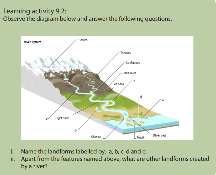
Youthful stage is the first stage of a river near its source. This stage is characterized by
a steep gradient, fast flowing water, vertical erosion etc. There are several landforms
that are created in this stage especially due to vertical erosion and the nature of the
gradient. The landforms like waterfalls and rapids, potholes and plunge pools are
the main landforms:
i. Waterfalls and rapids
Waterfalls abrupt movements of water or simply sudden descents of water due to
abrupt breaks in the longitudinal course of the river. Water falls are mostly caused by
variations in the relative resistance of rocks, relative difference in topographic reliefs,
fall in the sea level and related rejuvenation and earth movements. A waterfall,
therefore, is a vertical drop of a big volume of water from a great height along theprofile of a river.
Rapids are alternate breaks along the river’s profile. Rapids are smaller than
waterfalls. Generally, they are found upstream from the main falls, and are alsofound independently
ii. Potholes and Plunge pools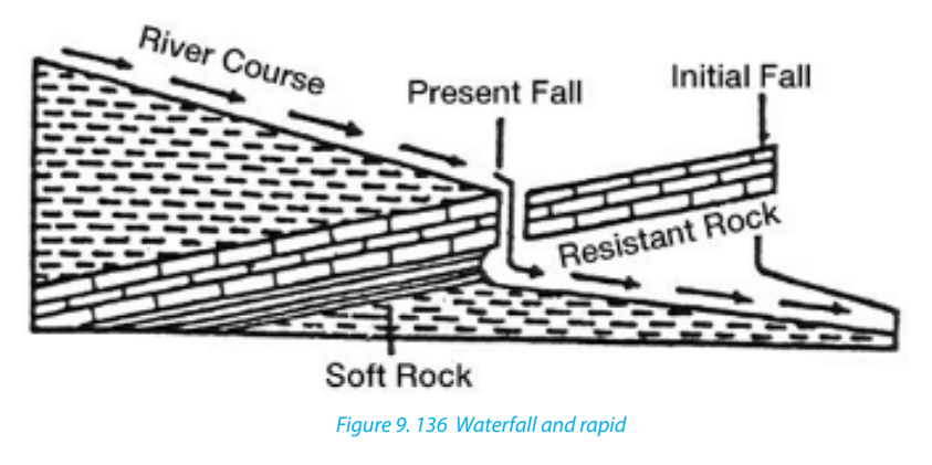
These are kettle-like and cylinder-shaped depressions in the rocky beds of the river
valley. They are circular depressions cut at the bed of the river by fast flowing water.
They are formed due to saltation and traction movement of large pebbles and
boulders on resistant rocks. Plunge pools are formed when pot holes are furtherwidened and deepened by circular and fast movements of water.
9.2.2. Formation of landforms in mature stage
A mature stage of the river is the middle stage of a river’s course where the gradient
is lower and where the river begins to flow slowly as it widens its channel.
The following are the major landforms:
i. River valleys: The valleys carved out by the rivers are significant erosional
landforms. The shape and dimension of fluvial originated valleys change
with the advancement of the stages of fluvial cycle of erosion.
ii. Gorges and Canyons: Are very deep and narrow valleys with steep sides/
slopes that are wall-like. They are formed when water falling over the hard
rock, undercuts the rock leaving it hanging. The hanging rocks may cause
water to retreat upstream leaving behind a narrow and deep sided valley
iii. Alluvial fans: These are fan-shaped deposits of coarse alluvium. They are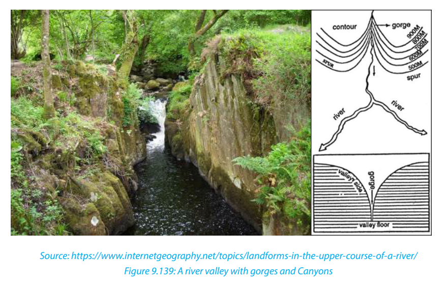
formed when a fast flowing river loses its velocity when it enters the gentle
slope. The river immediately deposits its load composed of course materials
especially rocks, boulders and bigger pebbles. The deposits are laid in formof a fan, hence the name, “alluvial fan”.

iv. River Benches: These are step-like flat surfaces on either side of the lowest
valley. The benches or terraces formed due to differential erosion of alternate
bands of hard and soft rock beds are called structural benches or terraces
because of lithological control in the rate of erosion and consequent
development of benches.
v. River terraces: The narrow flat surfaces on either side of the valley floor are
called river terraces which represent the level of former valley floors and theremnants of former (older) flood plains.
9.2.3. Formation of landforms in old stage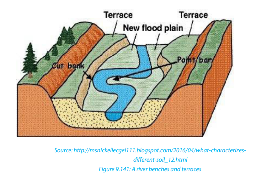
The lower or old stage of river is the last stage where a river nears its destination. This
stage is characterized by large deposits along the river’s bed and channel. The large
deposition is a result of increased lateral erosion, very slow movement of water and
very wide river channel. In this stage the river drops its load due to the reduction
in its energy. The material deposited by a river is called alluvium. River deposition
results into the formation of the following features:
i. River meanders: River meanders are the bends of the rivers. The bends of
sinuous rivers have been named meanders on the basis of Meander River
of Asia Minor (Turkey) because it flows through numerous bends. Each
bend of the meander belt has two types of slopes of valley sides. One side
is characterized by concave slope while the other side of the meander
belt is characterized by convex slope. The convex or slip off slope receives
deposition mostly of sands and gravels and alluvium at other times.
Therefore, the bank of maximum deposition is also called a slip-off slope.
The concave slope is a bank of maximum erosion or undercutting. It issteeper than the slip-off slope.

ii. An Ox-bow lake: This is a horse-shoe lake formed due to stagnation of water
in the abandoned meander loop. Ox-bow lakes are formed when a river
develops very pronounced meanders in the flood plains. As erosion and
deposition continues on the river’s banks, the neck of the meander is cut off
and the water flow straight by-passing the old meander. The abandoned orcut off meander therefore becomes an ox-bow lake.
iii. A Flood plain: This is a very gentle low-lying plain of alluvial deposits on
a floor of a river valley. It is formed where a river flows in a meandering
way. As a river swings back and forth across the valley, it widens its valley
floor. The valley becomes so broad that the meanders swing freely without
touching the valley sides. When the level of water rises during the flood
time, all the plain along the river valley becomes flooded. The river thendeposits its alluvium in the plain.
iv. Levees: These are raised river banks made up of alluvial deposits. Levees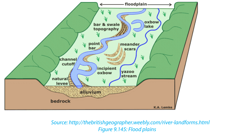
are formed when a river deposits its load along its banks during flooding.
Slightly coarse materials are deposited on the banks, while finer alluvium
is transported further onto the flood plains. With time, accumulation of
coarse material raises the banks of the river to form levees. During the dry
seasons, when the river retreats into its channel, deposition are left both
on the river’s bank and on its bed. This leads to the formation of raised riverbeds and banks.
v. Deferred tributaries: These are small tributary rivers that flow alongside
the main river. They are formed when raised levees stop tributaries from
joining the main stream. As a result, such tributaries, flow parallel to the
main river until they encounter a break in the river bank where they now
can join the main stream. They are thus referred to as deferred tributaries or
Yazoo streams. The point at which they join the main stream is referred to
as a deferred confluence. The tributary flows to the main channel and finallybreak through levees and join the main channel.
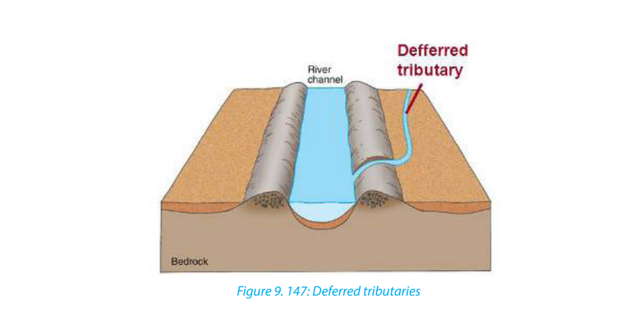
vi. Braided channel: This is a wide and shallow channel where a river breaks
into a series of interconnecting distributaries separated by sandbanks and
islands of alluvium. It is formed in the middle or old stage of a river where
the valley is wide and gently sloping. The river carrying a large load flows at
a low velocity, fails to transport its load and finally deposits its load on the
bed. Gradually, the river bed is raised and the deposits divide the flow ofwater into small tributaries and distributaries.
vii. Delta: A delta is a low-lying swampy plain of alluvium at the mouth of a river.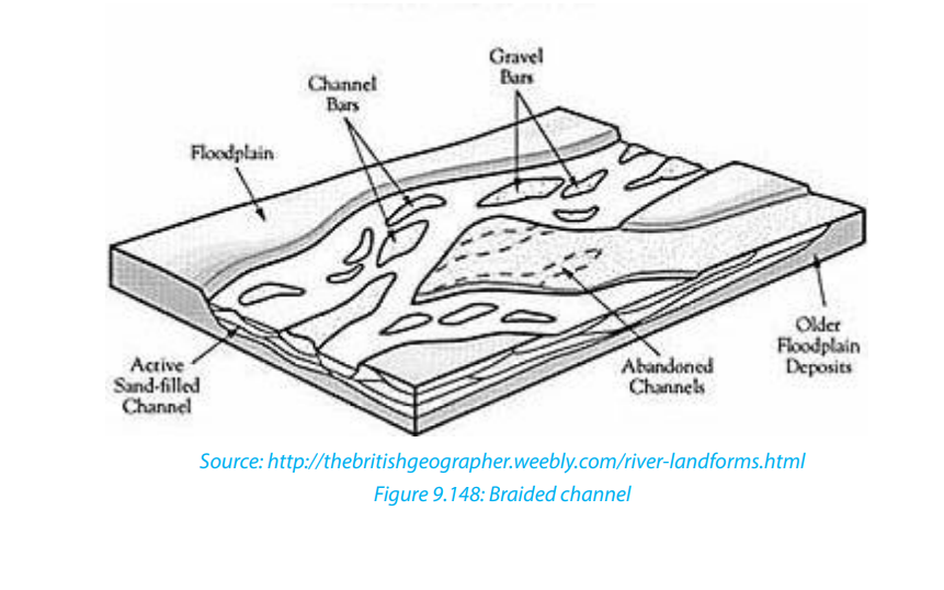
A delta forms when a river fails to push all its load into the sea or mouth
but deposits these into its mouth. The deposits divide the river’s mouth into
tributaries and sub tributaries. The deposits gradually become colonized by
various types of plants and forms a triangular shaped mouth of a river. This
is called delta. The growth of a delta. The river split up into several separate
channels in much the same way as river braids. Deltas are classified into two
categories depending on the shape and growth where there are growing
deltas and blocked deltas. They include the following:
• Estuarine deltas,
• Arcuate deltas,
• Bird’s foot deltas.
- Estuarine delta: This is a submerged mouth of a river. It is a delta formed from
materials deposited in the submerged mouth of a river. This takes the shape
of the estuary. Examples are the Zambezi Estuary in Mozambique, and Volta
Delta in Ghana.
- Arcuate delta: this is a triangular and convex shaped delta. It is formed by a
river with many distributaries transporting materials. It occurs where off-shore
currents are strong enough to round the seaward edge of the delta. Examples
are Sondu Delta in Kenya, Nile Delta in Egypt and Amazon Delta in Brazil.
- Bird’s foot delta: This is a delta that looks like the claws of a bird’s foot. It is
also known as digitate delta. It is formed when a river transporting large
load of mainly fine material enters into water that has low energy wave. The
distributaries extend from the shore into the open water. Examples are OmoRiver Delta on Lake Turkana and Mississippi Delta in the USA.
Application activity 9.2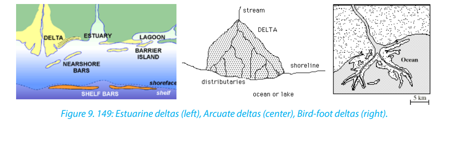
1. Visit the nearest rivers and do the following:
i. Identify the landforms formed along a river.
ii. Explain the importance of the above landforms to the local people.
2. Describe the relationship between landforms in the lower stage of ariver and human activities.
9.3. River capture and river rejuvenation
Learning activity 9.3
Make a research and establish the effects of the river capture and River
rejuvenation.
9.3.1. River capture
iii. Definition of river capture
River capture refers to the diversion of headwaters of a weaker river system into
a system of the stronger neighboring river. It is also referred to as river piracy. The
point of capture is known as “elbow of capture”. This point is usually found near
the dry valley or misfit stream. A misfit stream is the river whose water has been
beheaded or diverted into another stream. It contains very little or no water at all
and is not therefore fit to be in that river. This is why it is called misfit stream. Beyond
the misfit stream is a valley that no longer contains water. It is only covered by old
alluvial deposit. This is called a dry valley.
Features of river capture
There are four major features of river capture: elbow of capture, cols or wind gaps,misfit or under fit streams and dry valleys.
iv. Causes of river capture
A river capture can be caused by headward erosion, lateral erosion, or coalescence
of meanders. The following are the causes of river capture:• The presence of a river with a larger volume of water compared to its neighbourFor river capture to take place, the following conditions are necessary:
(the weaker river). The stronger river erodes its valley faster by vertical erosion
compared to its neighbour.
• The presence of soft and easily eroded rocks in the valley of a stronger river
• Earth movements like faulting, folding, warping and volcanicity on the valley
of a stronger river can also cause river capture
• Change in base level as a result of river rejuvenation. A fall or rise in a river’s
base level can cause river capture• There must be a powerful river or pirate stream and a misfit stream flowing• The pirate river must be flowing over easily eroded rocks compared to those
adjacent or parallel to each other.
• The pirate river must be flowing over a much steeper valley than the misfit or
beheaded stream
• The pirate river must be having more active head ward erosion compared toits neighbouring river
of its neighbour
v. Effects of river capture
The following are the effects of river capture (after the occurrence of river capture):• The volume of water in the pirate stream increases;9.3.2. River rejuvenation
• The capturing/beheading river becomes bigger and more stronger than it was
before capture;
• The beheaded stream having lost its waters contains very little water and
almost dries off (a misfit river);
• The pirate river develops an elbow of capture. This denotes a sharp change in
the direction of a river course (at the point of capture);
• The valley of the beheaded stream below the point of capture becomes dry
and hence the name, “wind gap”;
• Incision of the pirate river near point of capture. This valley becomes wider dueto increased vertical erosion (head ward erosion).
i. Definition of river rejuvenation
River rejuvenation is the renewed erosive activity of a river. It is an acceleration of
erosive power of the fluvial process of rivers. Rejuvenation length is the period of the
cycle of erosion. For example, if the cycle of erosion is passing through senile stage
(old stage) characterized by gentle channel gradient, sluggish river flow and broad
and shallow alluvial valleys, after rejuvenation (caused either due to substantial fall
in sea level or due to uplift of landmass) the cycle is interrupted and is driven back
to juvenile (youth) stage characterized by steep channel gradient and accelerated
valley incision.
There are three types of rejuvenation as follows:a. Dynamic rejuvenation: It is mainly caused by uplifting in the landmass,ii. Causes of river rejuvenation
tilting of land area and lowering of the outlet.
b. Eustatic rejuvenation: This occurs because of changes in sea level due to
diastrophic events (subsidence of sea floor or rise of coastal land) and
glaciations causing fall in sea level.
c. Static rejuvenation: Its main causes are decrease in the river load, increase
in the volume of water and consequent stream discharge due to increasedrainfall, increase in water volume of the main river due to river capture.
River rejuvenation is caused by the following:
• A fall in base level or fall in the level of the sea.
• Earth movements involving uplift, down faulting
• River capture which may cause an increase in the volume of water (river
discharge)• Change in rock resistance
iii. Effects of river rejuvenation on the landscape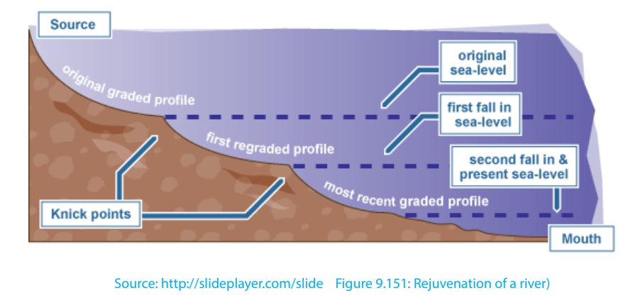
River rejuvenation produces several features as follows:
• Knick point: This is a break of slope in the long profile of a river valley. It
indicates the point where rejuvenation started. Knick points are associated
with rapids and water falls.
• Paired terraces: These are steps or bench-like river valleys on both sides of a
rejuvenated valley. They are marked by old alluvial deposits laid down before
river capture occurred. It is therefore a part of the former flood plain valley that
is above the present river level.
• Incised meanders: An incised meander is a curved bend of a river that has
been incised or cut into the land surface so that a river now winds between
steep valley walls. Incised meanders develop from an already meandering
river.
• Ingrown meanders: These are incised meanders with asymmetrical steep
valley sides. They develop on resistant rocks and where the base level fallsgradually and the meander shifts gradually and laterally
• Valley within a valley: This is also referred to as a rejuvenation gorge. These
are steps at the opposite sides of a rejuvenated valley. They form where
rejuvenation was very rapid with a large fall in base level. The river flows in a
deep channel within paired terraces that were once the remains of the floodplain.
Application Activity 9.3: 1.Observe the following picture and answer the questions that follow
i. Explain the factors that favour river capture.
ii. Describe the effects of river capture on the above figure.
2. Visit your local area, and identify a typical example of a rejuvenated riverand explain its causes.
Source: http://sageography.myschoolstuff.co.za/wiki/grade-12-caps/geomorphology/fluvial-procesrive
9.4. Drainage in the world
Learning activity 9.4:
Use internet and other geographical resources and describe the types ofdrainage patterns.
9.4.1 Drainage pattern in the world
A drainage pattern is the way in which a river and its tributaries arrange themselves
within their tributaries and distributaries. Most patterns evolve over a lengthy period
of time and usually become adjusted to the structure of the basin. The development
of the drainage patterns is influenced by:
• The gradient of the slope
• The nature of the bedrock. This is in terms of how resistant the rock is.
• The structure of the basement rock.
9.4.1. Types of drainage Patterns
There is no widely accepted classification of drainage, because most drainage
patterns are descriptive. Drainage patterns are however grouped into patterns
independent of structure, and those dependent on structure. There are also some
patterns apparently unrelated to structure:
i. Patterns dependent of structure
• Trellised drainage or rectangular drainage pattern are well adjusted to
the geological structures. In areas of alternating resistant and less resistant
rock, tributaries will form and join the main river at right-angles. Sometimes
each individual segment is of approximately equal length. The main river,
is also called a consequent river because it is a consequence of the initial
uplift or slope and flows in the same direction as the dip of the rocks. The
tributaries which develop, mainly by headward erosion along areas of weaker
rocks, are called subsequent streams because they form at a later date than
the consequents. Such patterns are developed in the area of simple folds
characterized by parallel anticlinal ridges alternated by parallel synclinal
valleys.
• Radial drainage pattern: This is a system where rivers/streams flow in a
circular way, outwards a central body. It develops in areas where the rocks have
been lifted up into a dome structure. Streams which diverge from a central
higher point flow in all directions. Dome structures, volcanic cones, residual
hills, small tablelands, mesas and buttes, and isolated uplands can favour thedevelopment of ideal radial pattern.
• Centripetal drainage pattern or inland drainage pattern: This is the
opposite to the radial drainage pattern because it is characterized by
the streams which flow and converge at a point which is generally a
depression or a basin. This pattern is formed by a series of streams which
after emerging from surrounding uplands converge in a central low land
which may be a depression, or a basin or Crater Lake. The best examples
are found on Lake Victoria with rivers like R Nyando, River Akagera, River
Mara and River Katonga
• Annular drainage pattern: This is also known as “circular pattern”,
is formed when the tributaries of the master consequent streams are
developed in the form of a circle. Such pattern is developed over a mature
and dissected dome mountain characterized b y a series of alternatingbands of hard and soft rock beds.

• Herringbone drainage pattern: This is also called rib pattern (like the
rib bones of human beings) is developed in mountainous areas where
broad valleys are flanked by parallel ridges having steep hillside slopes.
The longitudinal consequent streams, as master streams, are developed in
the longitudinal parallel valleys while tributaries, as lateral consequents,
after originating from the hill slopes of the bordering parallel ridges jointhe longitudinal consequents almost at right angles.

ii. Patterns independent of structure
• Dendritic drainage pattern: This derives its name from the Greek word
Dendron, meaning a tree, this is a tree-like pattern in which the many tributaries
(branches) converge upon the main river (trunk). It is a common pattern which
develops in basins having one rock type with no variation in structure.
• Parallel drainage pattern: This occurs on newly uplifted land or other
uniformly sloping surfaces which allow rivers and tributaries to flow downhill
more or less parallel with each other (e. g. rivers flowing south-eastwards fromthe Aberdare Mountains in Kenya).
Dendritic drainage patterns Parallel drainage pattern
iii. Patterns apparently unrelated to structure
• Barbed d r a i n a g e pattern: This is a l s o c a l l e d hooked drainage
p a t t e r n , is a rare kind of drainage pattern formed when the tributaries
flow in the opposite direction to their master streams. The tributaries join
their master streams in hook-shaped bends. Such a pattern is generallydeveloped due to river capture.
• Pinnate drainage pattern: This is developed in a narrow valley banked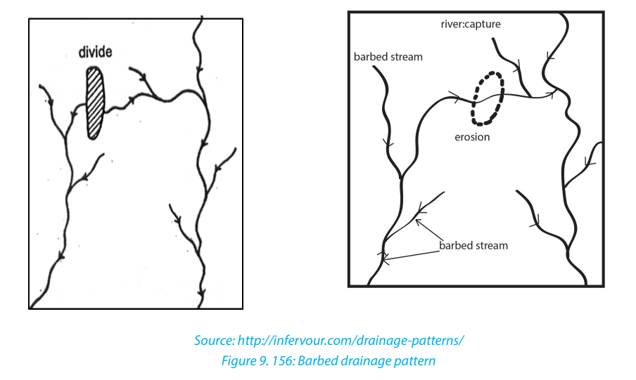
by steep ranges. The tributaries originating from the steep sides of parallel
ridges join the longitudinal master consequent occupying the valley atacute angles.
9.4.2. Superimposed and antecedent drainage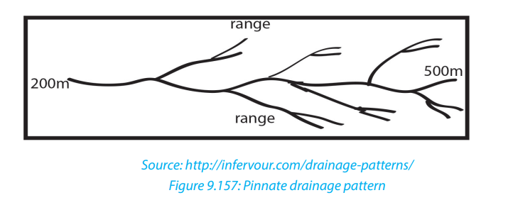
i. An antecedent drainage:
This is a drainage made of streams that maintain their original course and pattern
despite the changes in underlying rock topography. Antecedence is when the
drainage pattern developed before such structural movements as the uplift or
folding of the land, and where vertical erosion by the river was able to keep pace
with the later uplift. A stream with a dendritic drainage pattern for instance, can
be subject to slow tectonic uplift. However, as the uplift occurs, the stream erodes
through the rising ridge to form a steep-walled gorge. The stream thus keeps its
dendritic pattern even though it flows over a landscape that will normally produce
a trellised drainage pattern.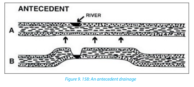
ii. A superimposed drainage:
This kind of drainage pattern seems to have no relationship to the present-day
surface rocks. Superimposed pattern is a drainage that formed over horizontal
beds that overly folded and faulted rock with varying resistance. The stream erodes
through the underlying horizontal beds, and retains its course and pattern despite
changes in the underlying rock. The stream erodes a gorge in the resistant bed andcontinues its flow as before.
9.5. Impact of rivers
Application activity 9.4
1. Visit any nearby river and identify its pattern of drainage and explain how
this pattern was developed.
2. Describe the formation of antecedent and superimposed drainage.
Learning activity 9.5
Describe the developmental activities that are done along any river valley in
your locality or in the world
9.5.1 Impact of rivers
Rivers play an important role both to human beings and the surrounding
environments. Rivers can also negatively affect people and the surrounding
environments.
The rivers and riverine landforms influence human beings positively:• Rivers provide water for various uses such as domestic, industrial uses, drinkingNegative effects
by animals.
• Navigable rivers provide natural route-ways used for transportation.
• Rivers provide water for irrigation especially in areas of low rainfall. This
promotes agriculture, hence increasing food production.
• Waterfalls provide natural sites for the production of hydroelectric power.
Examples are: waterfall between lakes Burera and Ruhondo, River Rusizi in
Rwanda, River Tana in Kenya, River Volta in Ghana, water falls along River Nile,
etc.
• River Ria, estuaries and deltas are deep and sheltered, hence they promote the
development of ports like Alexandria on the Nile delta.
• Building materials such as sand, gravel and pebbles are obtained from river
beds and valleys.
• Some rivers have spectacular features such as waterfalls, gorges and canyons
which attract the tourists. For example, Rusumo falls on river Akagera in
Rwanda.
• Alluvial deposits in some river valleys are a source of valuable minerals such
as alluvial gold for example in Miyove valleys in Northern Province of Rwanda.
• Building materials such as sand, gravel and pebbles are obtained from
riverbeds and valleys.
• Flood plains and deltas contain fertile alluvial soils which have been exploited
for agriculture. Example is the Nyabarongo river valley, Nile valley in Egypt etc.
• The livestock activities are mostly developed near water bodies where drinking
and green vegetation water is available throughout the year
The rivers and riverine landforms influence human beings negatively:• Some large rivers form barriers to communication between communities of
the same culture.
• During flooding some rivers cause destruction of property and loss of human
life.• Some river water may act as a medium for the spread of water borne diseases,for example, Malaria, Bilharzia.
• Some rivers harbour dangerous animals such as crocodiles and9.5.2. Case studies of rivers: Major rivers of the worldhippopotamuses. These at times attack human beings and destroy crops.
The following are the major rivers of the world.
i. Amazon River is the largest river in the world. It is found in South America.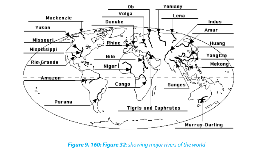
It is 6,400 km long. It has a drainage basin of 7,050,000 square km. It also
carries more water than any other river in the world. It can reach a width of
200 km. The Amazon River flows across North Brazil.
ii. The Nile is the longest river in the world. It is 6,853 km long. Its drainage
basin covers 3,400,000 million square km. The source of River Nile is Lake
Victoria. It flows into the Mediterranean Sea. The river passes through
Uganda, South Sudan, Sudan and Egypt.
iii. Ganges River: it is a trans-boundary river o Asia which flows through the
nations of India and Bangladesh. The 2,525 km (1,569 mi) river rises in the
western Himalayas in the Indian State of Uttarakhand, and flows south and
east through the Gangetic of North India into Bangladesh, where it empties
into the Bay of Bengal. It is the third largest river in the world by discharge.
The Ganges is the most sacred river to Hindus. It is also a lifeline to millions
of Indians who live along its course and depend on it for their daily needs. It
is worshipped as the goddess Ganga in Hinduism. The Ganges was ranked
as the fifth most polluted river of the world in 2007. Pollution threatens not
only humans, but also more than 140 fish species, 90 amphibian species
and the endangered Ganges river dolphin.
iv. Congo River is the second longest river in Africa. It is 4,700 km long. It has
a basin of 4,000,000 square km. It is made up of two tributaries. These are
Lualaba and Luapula. It flows through northern and western Democratic
Republic of Congo (DRC) into the Atlantic Ocean.
v. The Niger River is the third longest river in Africa. It is 4,180 km long. The
river begins in Guinea and runs east through Benin, Guinea, Mali, Niger, and
Nigeria. Its main tributary is the Benue River.
vi. The Mississippi River is found in North America. It is 3,734 km long. Its
basin is 2,981,076 square km. The source of the river is Lake Itasca. It passes
through mid-United States to the Gulf of Mexico.
vii. Missouri River is the longest river in North America. It is 4,130 km long.
The Missouri is the longest tributary of the Mississippi. The source of the
Missouri is the meeting point of Rivers Jefferson and Madison. It joins
Mississippi River at St. Louis.
viii. The Danube River begins in the Black Forest in Germany. It flows eastwards
for a distance of some 2,850 km, passing through four Central and Eastern
European capitals. It empties into the Black Sea through the Danube Delta
in Romania and Ukraine.
ix. Rhine River is 1,320 km long. It is the second longest river in Central and
Western Europe. It begins in the Swiss Alps. The Rhine flows through six
countries. These are Switzerland, Liechtenstein, Austria, Germany, France
and the Netherlands. It empties into the North Sea at Rotterdam.
x. Volga River is the longest river in Europe. It is 3,700 km long. It is located in
Central and Eastern European Russia. The source of River Volga is the Valdai
Hills to the northwest of Moscow. It empties into the Caspian Sea.
xi. Huang He/Hwang Ho/Yellow River is the third longest river in Asia. It
is 4,830 km long. Its source is the twin lakes Gyaring and Ngoring in the
Kunlun Mountains. to the northwest of Qinghai province.
xii. Chang or Yangtze Mandarin Chang Jiang is the longest river in China.
It is 6,245 km long. It rises in the Tibetan highlands to the southwest of
Qinghai Province. Western China and flowing generally Eastern through
central China into the East the river passes through one of the world’s
most populated regions. It has for many years been used as a trade andtransportation route.
9.5.2 Case Study of the Nile River in Egypt
Extract from: UK ESSAYS. (March, 2015). The importance of the Nile River.Environmental science essay
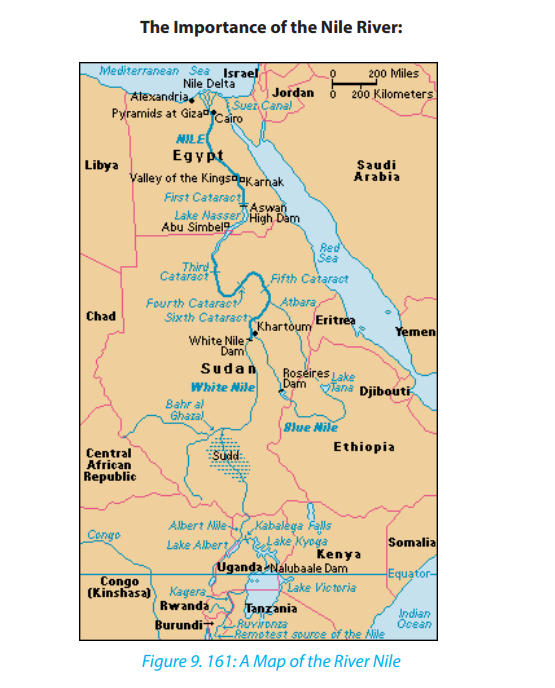
Egypt would be almost all barren deserts without the Nile. The Nile is one of the most
important things that Egypt can’t live without. No one can deny that the Nile was so
important to the pharaohs in their daily life. The pharaohs were so smart, they used
the Nile so well to help them in their life. The pharaohs used the Nile for agriculture.
The pharaoh got all the rich peasants to do the farm work on the rich lands. Most
of the ancient villagers were farmers. Egyptians grew several crops such as wheat,
barley, vegetables, figs, melons, pomegranates and vines. The most important
crop at this time was grain. The pharaohs used grain to make bread, porridge and
beer. The Grain was the first crop they grew after flooding season. Once grain was
harvested, they grew vegetables such as onions, cabbages, beans, cucumbers and
lettuce. Farmers planted fruit, trees along paths, to give shade as well as fruit. The
Egyptians grew their crops along the banks of the River Nile on the rich black soil
which was considered one of the best soils for agriculture in the world. This rich soil
was left behind after the yearly floods. This soil was ideal to grow healthy crops.
Egyptian farmers divided their year into three seasons, based on the cycles of the
Nile:
Farming was not done during the flooding season as all the fields were flooded.
Instead, many farmers worked for the pharaoh, building pyramids or temples. Some
of the time was spent mending their tools and looking for animals. The Growing
Season which starts in October, the flood waters recedes, leaving behind a layer of
black soil.
Shemu which starts in March and ends in May and called also The Harvesting
Season. The fully grown crops had to be harvested and removed before the Nile
is flooded again. It was also the time to repair the canals to be ready for the next
flood. Every June in the year, the Nile flooded. This was known “the flooding season”.
During this time the farmers mend tools or make new ones. People would go fishing
for extra food or money. To lift the water from the Nile they used a shaduf. A shaduf
is a large pole balanced on a crossbeam, a rope and bucket on one end and a heavy
counter weight at the other end. By pulling the rope it lowered the bucket into
the Nile River. The farmers then raised the bucket of water by pulling down on the
weight. He then swings the pole around and emptied the bucket onto the field.
Nowadays Egyptian are sticking to the Nile from ancient Egyptians to modern Egypt
which prove how living beside the Nile is important and living beside the Nile make
life easier.
Why the Nile River Flooded?
Rains in Africa, especially rains coming from the Ethiopian Highlands, and melting
snow caused the Nile River to flood. The Ancient Egyptians used something called
Nilometer to record how high the Nile was during the year.
The flood still continues every year. The annual flood carries dead and decaying
plants in its muddy solution. The muddy water is called silt, and silt creates excellent
farm soil. Since 1970, the Aswan Dam has controlled the annual flood of the Nile River
by holding back water, the Aswan Dam created the world’s largest man-made lake:
Lake Nasser. The water from Lake Nasser provided new fishing areas and provides
much needed water for agriculture.
Since the Nile was so important in old Egyptian history, so it’s for sure that the Nile
importance increased now much more .One of the most important thing that Egypt
gets benefit due to the Nile is the High Dam. The high dam is located in Aswan. It
was completed in 1970. It cost one billion dollar; its capacity is 5.97 trillion cubic feet.
It was built to control the flood and to obtain from it hydroelectric power and it isalso used in irrigation.
The Aswan High Dam captures water flood during rain seasons and releases the
water during times of drought. The dam also generates enormous amounts of
electric power more than 10 billion kilowatt every year. That’s enough electricity
to power one million color televisions for 20 years continuously. Unfortunately,
the dam has also several negative side effects. In order to build the dam, Egyptian
peasants had to move. To make matters worse, the rich silt that normally fertilized
the dry desert land during annual floods is now at the bottom of Lake Nasser which
lead to that the Farmers have been forced to use about one million tons of artificial
fertilizer as a substitute for natural nutrients that once fertilized the arid floodplain.
A lot of research proved that Egyptians prefer living along the Nile River because it’s
much easier for their life rather than living in the desert or away from the Nile River.
One of the most important things is using the Nile as main source for water. Water
is one of the most important things for the human body because the human body
consists of 60% of water which is a very big percentage .The health of the human
body cannot work properly without the proper hydrations of the body .we have to
drink half of our body weight in ounce every day. The water is very important for
every organ inside our body. The brain consist 85% of water, the bones consist of
35% of water, blood consist of 83% of water and the liver consist of 90% of water.
This proves how much the water is so important.
There are a lot of economical projects that were made based on the Nile River. The
first project that we are going to talk about is the high dam. As we said before, the
high dam costs 1 billion dollar and can contain 5.97 trillion cubic feet of water. The
high dam provide Egypt from south to north with high amount of electricity to run
up their machine such that television, computer, lamps and their appliances. A lot
of countries have problem for obtaining high amount of electricity like that in that
easy way. This proves how this project which was based on the Nile is so essential
now for the Egyptian and can’t live without it.
The second project that we are going to talk about is the Nasser Lake. The Nasser
Lake is one of the biggest and best artificial lakes that were made with the water of
the Nile River.
Tourists come all over the world to see this beautiful lake which was handmade by
Egyptians on the Nile river water. The lake extends for 350 miles which is about 560
kilometers and is about 6 mile which is about 10 kilometer wide. Tourists come there
to see the impressive variety of animals. There people can find variety of mammals,
reptiles and birds.
Tourist also visits this wonderful lake for fishing trip because this lake contains about
32 different fish species which is a large number.
The Third Project is Tuskha Project .This Project is capable of converting all the desert
lands in Egypt into agricultural land. The Nile played a very important role in tourism,
all tourists come all over the world to see how the Nile is great and they take a cruise
from north Egypt to south Egypt and visit all the beauty which is on the Nile. The Nile
can be used for a very important activity which is transportation. Egypt has a very
big problem which is traffic jam. This is why the government should begin to plan
how to use the Nile as a very good way for transportation. The Nile can be used in
transporting people from one city to another. The government can also use the Nile
in trading which will be very effective and will be a very good solution for the traffic
jam because most of the traffic jam is because the trucks and the big buses, so the
government should put this solution in the plan because it will help in developingEgypt to the good in the future.
In Egypt, No one can live without the Nile River because no one can live without
water this is why Nile is like the main artery of Egypt. The Nile is considered the only
weapons that protect Egypt from the upcoming water war that will destroy a lot of
countries. The Nile should be used to make project to increase Egypt economy suchas the Aswan high dam, the Nasser Lake and the toshka project.
Application activity 9.5:
Referring to any river in Rwanda like Mukungwa, Nyabarongo, Akanyaru,
Base or Akagera rivers, describe the relationship between human activitiesand the surrounding river.
9.6. Lakes, Seas and Oceans
Learning activity 9.6.
Use internet and other geographical resources to research on:
i. Types of lakes and their mode of formation,
ii. Name 10 largest seas and five largest oceans in the world.
9.6.1 Types of Lakes
A lake is a large mass of water that occupies a basin or depression on the surface of
the earth. Lakes receive water from streams, overland flow, and ground water, and
so they form part of drainage systems. Lakes may be permanent or seasonal. This
depends on the volume of water that gets in, and the amount of water that is lost.
The loss of water is through evaporation and river outlets.
Lakes are categorized according to their mode of formation. They are grouped invarious ways as follows:
• Through earth movements (tectonic lakes)
• Volcanic action (lava dammed and crater lakes)
• Erosion (erosional lakes)
• Deposition (depositional lakes)• Human activities (man-made lakes)
9.6.2 Mode of formation of Lakes
The lakes are differentiated on the basis of their mode of formation. The following
are the major modes of lakes’ formation.
a. Lakes formed by earth movements
• Lakes caused by crustal warping: These are lakes that occupy a basin-like
depression. They were formed when water occupied down warped basins
immediately after crustal warping. These lakes are also called subsidence
Lakes. Examples are Lake Chad and Lake Victoria in Africa. In Rwanda, Lakeslike Muhazi, Mugesera, Cyohoha were also formed as a result of subsidence.
• Rift Valley Lakes: These are Lakes that occupy depressions within rift valleys.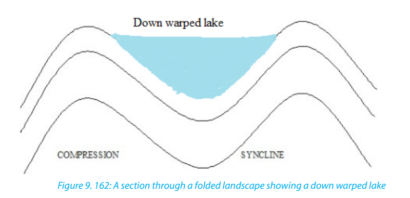
They are usually deep, elongated, and have steep sides. They are located on
the floor of a rift valley. Examples are Lakes Kivu in Rwanda, Turkana in Kenya,Tanganyika and Malawi in Tanzania
b. Lakes produced by glacial erosion and glacial deposition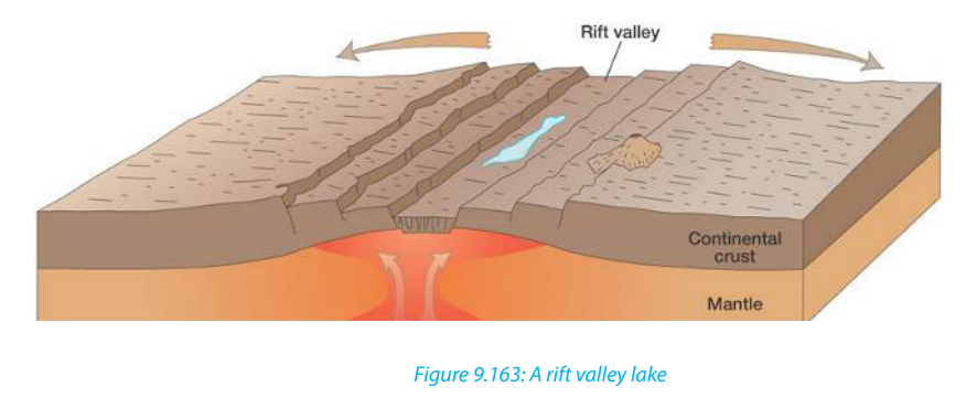
• Cirque/Tarn Lake: This is a Lake that forms in a glaciated highland. Such lake
occupies an armchair-like depression, called a cirque. During thawing (melting
of snow), water collects in circular depressions that were left behind where
large avalanches or boulders were uprooted by melt glaciers. A cirque lake,
often called a tarn, sometimes feeds a mountain river. Tarns occur on the sidesof Mount Kenya like Teleki Tarn and on Mt Rwenzori for example Stanley Lake.
• Trough Lake: This occupies an elongated hollow excavated by ice on the floor
of U-shaped valley. It is sometimes called a ribbon lake. Lake Michaelson, inthe Gorges Valley, near to Mount Kenya, is a trough lake.
• Kettle Lakes: These are small lakes that are formed in depressions in glaciated
lowlands. They are formed when melt water occupy depressions called kettle
holes.
• Moraine dammed lakes: These are lakes that form in glaciated lowlands when
a moraine dams the flow of melt waters in glaciated lowlands.
c. Lakes produced by wind erosion
These are lakes that form in desert depressions left behind where large masses of
sand dunes and pebbles have been removed. Wind deflation sometimes produces
extensive depressions which reach down to the water-table in arid deserts. The
lakes of these depressions are not always true lakes-they may be nothing more thanmuddy swamps. The Quattara depression, in Egypt, is a good example.
More permanent desert lakes develop when an aquifer becomes exposed. These
lakes are called oases. Some desert lakes dry up because of excessive evaporation
and all that remains is a lake bed of salt. This is called a playa or a Salt Lake.
d. Lakes produced by river deposition
• Ox-bow Lake: It is formed when a meander loop of a river on a flood plain
is cut off from the main river. The river Galma, in Nigeria, has several ox-bowlakes.
• Delta Lake: This Lake is formed by the deposition of alluvium by rivers turning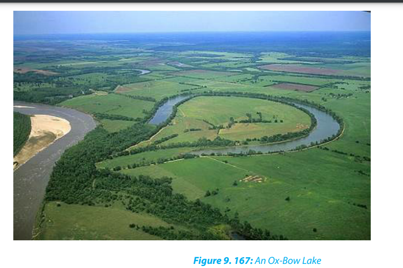
either a part of the sea into a lagoon, or part of a distributary into a lake. TheEtang de Vaccares is a delta lake. Delta lakes occur in the Nile Delta, in Egypt.
e. Flood plain Lake: A levée sometimes prevent water from returning to the
river, thus causing a lake to form. There are several lakes of this type on theRiver Congo.
f. Boulder clay Lake: Some boulder clay deposits contain depressions which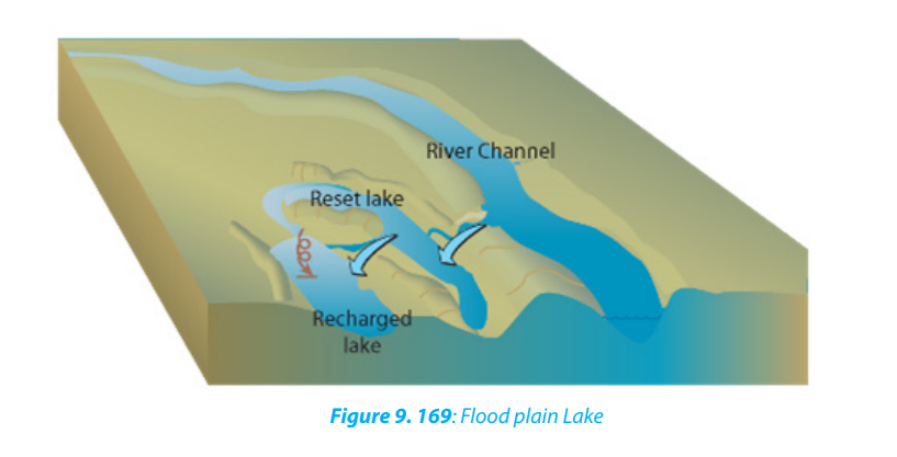
become the sites for lakes. There are lakes of this type in Northern Ireland.
g. Lakes produced by marine deposition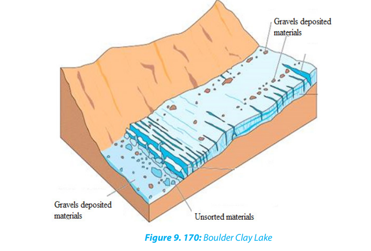
Lagoon: This is a lake formed by a sand bar or sand spit extending along a coast
and cutting off a coastal indentation hence forming a lagoon. Sometimes a barrier
beach extends across the mouth of a river, producing a lagoon.
9.6.3. Impact of lakes
The usefulness of lakes to human society are briefly described below.
• Source of fish: Lakes are habitats for different varieties of fish. This has favoured
the development of fishing and related industries.
• Source of minerals and natural gases: lakes such as Magadi in Kenya, Natron
in Tanzania and Katwe in Uganda are source of salt, Lake Kivu in Rwanda
contains natural gas.
• Tourism: Lakes provide beautiful sceneries and other activities which attract
tourists. This earns a country foreign exchange.
• Cheap transport: Lakes form cheap natural waterways for goods and
passengers.
• Source of power: Some lakes have been harnessed for the generation of
hydroelectric power. For example, Lakes Burera and Ruhondo generate power
on Ntaruka hydroelectric power plant.
• Source of useful water: Lakes are sources of water for domestic and industrial
uses.
• Source of drinking water for animals like cattle, sheep, goats, etc.
• Source of building materials: Some lakes are source of building and
construction materials such as sand, pebbles, small rocks, water used in
construction, etc.
• Regulating river flow: Some lakes help in controlling floods by regulating the
flow of rivers.
• Modification of climate: Lakes are important factors controlling the climate
of the surrounding areas because they provide the moisture. The lakes also
modify the climate of the adjacent areas.
• Source of rivers: Some lakes are sources of rivers. They act as reservoirs and
stores of water to rivers. For example, Lake Kivu is a source of river Rusizi, Lake
Muhazi is source of Nyabugogo River, etc.
9.6.4 Distribution of seas and Oceans
a. Distribution of Seas
A sea is a very large mass of saline water that occupies a very huge depression. Seas
occupy large basins on the continental margins. Lakes are smaller than seas but seas
are also smaller than oceans. Seas are of two types namely:• Inland seas. These are shallow seas over part of a continent. They are connected
to oceans by straits
• Marginal Sea. This is a sea partially enclosed by islands, archipelagos, or
peninsulas, adjacent to or widely open to the open ocean at the surface, and/or bounded by submarine ridges on the sea floor.

b. The distribution of oceans
An ocean is a large mass of saline water. Oceans occupy basins between continents.
There are five oceans in the world. These are as follows:
• Southern (Antarctic) Ocean: with an area of 20 million kilometers square
• Arctic Ocean: with an area of 14 million kilometers square
• Indian Ocean: with an area of 68.5 million kilometers square
• Atlantic Ocean: with an area of 76 million kilometers square
• Pacific Ocean: with an area of 155 million kilometers square
9.6.5. Importance of seas and oceans
Oceans and seas are very important either to human beings or to climate and the
adjacent areas. The following are the importance of oceans and seas:
• Source of fish: Oceans and seas form habitats for fish. This has promoted the
development of fishing and related industries.
• Tourism: Lakes provide beautiful sceneries which attract tourists. This earns a
country foreign exchange.
• Cheap transport: Ocean and seas are used by ships in transporting goods and
passengers.
• Source of useful water: Oceans and seas provide water for domestic, industrial
uses.
• Source of drinking water for animals like cattle, sheep, goats, etc.
• Regulating river flow: Some seas help in controlling floods by regulating the
flow of rivers.
• Modification of climate: Oceans and seas are important factors controlling
the climate in a given area because they provide the moisture. The oceans and
seas also moderate the climate of a given area.• Ends/sources of rivers: Some seas and oceans form sources/ends of rivers
Application activity 9.6
1. Draw a sketch map of Rwanda and on it indicate the types of Lakes.2. Explain their mode of formation.
9.7 Marine Relief
Learning activity 9.7.
Use internet and geographical resources and answer the following questions:
i. Explain the types of Marine relief.ii. Identify the location of Great Barrier Reef in Australia
9.7.1 Marine Relief
Ocean basins are characterized by five relief zones: continental shelves, continental
slopes, deep-sea plains, oceanic trenches and oceanic ridges.
i. Continental shelf (platform): This is a continental marginal area submerged
under oceanic water with average water depth and gently sloping towards
the sea or ocean. The width of continental shelves largely depends on the
nature of relief of the coastal land.
ii. Continental slope: This is a zone of steep slope extending from the
continental shelf to the deep-sea plains.
iii. Deep sea plains (Abyssal Plains): A deep sea plain is a flat and rolling
submarine plain in the ocean/sea basin. These deep-seated plains are found
in the depth from 3000m to 6000m.
iv. Oceanic trenches (deeps): Oceanic trenches are depressions of the sea
floor, relatively narrow in width, but very long. They are the deepest parts of
the ocean floor. Very deep but less extensive depressions are called deeps
while long and narrow linear depressions with steep side slopes are called
trenches. For example, the Mariana trench in western Pacific Ocean is thedeepest in the world.
v. Ocean ridges: The submarine ridges with steep side-slopes sometimes
reach the sea level and even project above the water surface and appear asislands. For example, the Mid-Atlantic ridge in the Atlantic ocean.
9.7.2 A case study of the Great Barrier Reef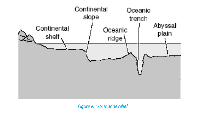
The Great Barrier Reef is the world’s largest coral reef system composed of over 2,900
individual reefs and 900 islands stretching for over 2,300 kilometres (1,400 mi) over
an area of approximately 344,400 square kilometres. The reef is located in the Coral
Sea, off the coast of Queensland in Australia.
The Great Barrier Reef can be seen from outer space and is the world’s biggest single
structure made by living organisms. This reef structure is composed of and built by
billions of tiny organisms, known as coral polyps. It supports a wide diversity of life
and was selected as a world Heritage site in 1981. The Queensland National Trust
named it a state icon of Queensland.
A large part of the reef is protected by the Great Barrier Reef Marine Park, which
helps to limit the impact of human use, such as fishing and tourism. Other
environmental pressures on the reef and its ecosystem include run off, climate
change accompanied by mass coral bleaching, and cyclic population outbreaks ofthe crown-of-thorns starfish.
The Great Barrier Reef has long been known to and used by the Aboriginal Australian
and Torres Strait Islander peoples and is an important part of local groups’ cultures
and spirituality. The reef is a very popular destination for tourists, especially in theWhitsunday Islands and Cairns regions.
Application activity 9.7
1. Describe the contribution of marine relief to the aquatic life.
2. Discuss the economic importance of the Great Barrier Reef to the peopleliving in Australia.
9.8. Ocean currents
Learning activity 9.8
Observe the map provided below and identify the major types of Oceancurrents in their respective locations.
9.8.1 Definition, types and location of major ocean currents
Definition
Ocean currents are slow and steady movements of a mass of oceanic water in a
definite direction. It is more or less similar to water streams (rivers) flowing on the
earth’s surface. Ocean currents are the most powerful of all dynamics of oceanic
waters because they pass over thousands of kilometers. Ocean currents are
categorized according to their areas of origin and temperature. They are warm
ocean currents and cold ocean currents. They are divided, on the basis of velocity,
dimension and direction into drifts, currents and streams.
Types and location of major ocean currents
Ocean currents are classified into surface or horizontal currents and vertical ocean
currents. Surface currents move water horizontally parallel to the earth’s surface.
Surface currents are powered by wind. Friction between wind and water causes the
water to move, driving ocean water in huge circular patterns all around the world.
Surface ocean currents include warm currents also called equatorial currents.
Trade winds drive the ocean surface waters westward in a concentrated channel
along the equator. As these surface currents approach the western margins of the
oceans, the water actually piles up against the eastern shores of the continents. This
phenomenon is the western intensification.
The piled-up ocean water then goes where it can, spilling northward and southward
in strong currents, flowing in tight channels along the eastern shorelines. As these
currents move towards the west, they are deflected by continents and move either
direction northward and southward along the eastern coasts of continents. For
instance, in the Northern Hemisphere, the Gulf Stream and the Kuroshio (a current
east of Japan) move forcefully northward as a result of western intensification.
Cold ocean currents, also called cool ocean currents, move toward the East. Being
colder with higher density, they flow to replace warmer and lesser dense equatorial
surface currents moved westward which are actually being deflected left and
right by continents at their eastern coasts. These currents are deflected by westernmargins of continents and converge at the equatorial zone.
Ocean currents are located both on the western and the eastern coasts of continents.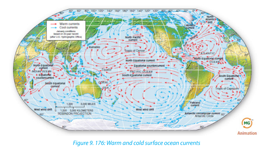
Several ocean currents have different names according to their areas of origin or
temperature. Major ocean currents of the world and their names are presented onthe map provided below.
Cold ocean currents
1. Californian Current
2. Humboldt current
3. Labrador current
4. Canaries current
5. Banguela current
6. Falkland current
7. West Australian current
8. Okhotsk current
Warm ocean currents
1. North pacific drift
2. North Equatorial current
3. Equatorial counter current
4. South Equatorial current
5. West wind drift
6. Gulf stream
7. North Atlantic drift
8. North Equatorial current
9. Equatorial counter current
10. South Equatorial current
11. Brazil current
12. West wind drift
13. Monsoon current
14. Equatorial counter current
15. South equatorial current
16. Mozambique current
17. West wind drift
18. Japan current
19. North equatorial current
20. Equatorial counter current
21. South Equatorial current
22. East Australian Current
Vertical ocean currents include upwelling and downwelling flows
Where surface water is swept away from a coast, either by surface divergence
(induced by the Coriolis force) or by offshore winds, an upwelling current occurs.
Upwelling is a circulation in the ocean that brings deep, cold water to the ocean
surface. In upwelling, wind blowing offshore carries water away from the land. When
surface water is pushed away, cold water from deep in the ocean rises to replace thevacating water. This cool water, generally, is nutrient-rich. Regions where this occurs
are known as good fishing areas. Such cold upwelling currents exist off the Pacific
coasts of North and South America and the subtropical and mid-latitude west coast
of Africa. These areas are some of Earth’s prime fishing regions.
In other regions with an accumulation of water - such as at the western end of an
equatorial current, or in the Labrador Sea, or along the margins of Antarctica - the
excess water gravitates downward in a downwelling current. These are the deep
currents that flow vertically and along the ocean floor and travel the full extent of
the ocean basins, carrying heat energy and salinity.
9.8.2 Causes and characteristics of ocean currents
a. Causes of ocean currents
Surface ocean currents, like surface winds, are influenced by the Coriolis Effect. The
Coriolis effects deflects currents north of the equator, such as the Gulf Stream, to
the right. Currents south of the equator are deflected to the left. The continents
also influence ocean currents. Currents moving towards the west in the Pacific
are deflected by Asia and Australia. The current deflected by Coriolis Effect move
eastward until North and South America deflects them.
There are several factors or causes of ocean currents. These are:
• The factors relating to the earth’s nature and its rotation such as gravitational
force and deflective force by earth’s rotation.
• Oceanic factors like pressure, gradient, temperature variations and salinity
differences.
• Ex-oceanic factors like atmospheric pressure and winds, evaporation and
precipitation.
• Current modifying factors like direction and shape of coastlines, relief of the
ocean basins, seasonal variations and rotation of the earth.
b. Characteristics of ocean currents
• Ocean currents are classified as either warm or cold depending on their origin
and temperature.
• Ocean currents which flow from the Equator towards the poles are warm,
while those flowing from the poles towards the Equator are cold.
• In the Northern Hemisphere, Ocean currents move clockwise, while in the
Southern Hemisphere, their movement is anticlockwise.
• Warm ocean currents occur mainly on the eastern margins of continents, while
cold ocean currents occur on the western margins of continents.
Geography Senior Six Student Book 273
9.8.3 Influence of ocean currents on the climate and e adjacent lands
the Ocean currents have both positive and negative influences on climate and theadjacent lands. These influences are:
• Modification in the coastal climate and inlands: Ocean currents while
flowing along the coasts modify their weather conditions in a number of ways.
The most effective impacts of ocean currents are seen on the temperature of
affected coastal lands. The effects are both positive (beneficial) and negative
(injurious) to flora and fauna.
• Ocean currents help in maintaining the temperature balance of ocean
water as the warm currents transport warm waters of the tropical zones to the
colder areas of the temperate and polar zones and cold currents bring cold
waters of high latitudes to the areas of low latitudes.
• Cold ocean currents, on the other hand, lower down the temperature
considerably of the affected areas and thus cause snowfall. The winds blowing
over warm currents pick up moisture and help in increasing the amount of
precipitation in the affected coastal areas.
• Effects on fishing: Ocean currents act as distributing agents of nutrients,
oxygen and other elements necessary for the existence and survival of fishes.
Ocean currents transport planktons from one area to another area. These
planktons are useful food for fishes.
• Effects on trade and navigation: Ocean currents were used to determine
major ocean routes for the navigation of commercial ships in ancient times.
Today’s power-motored ships do not rely the ocean currents and prevailing
winds for guidance. The occurrence of fog due to convergence of warm and
cold currents poses serious threats to navigation. Larger icebergs brought bycold currents damage ships.
Application activity 9.8
1. Explain why some ocean currents are warm whereas others are cold.2. Describe the effects of ocean currents to the climate of East Africa
9.9. Ocean tides: Definition, types, causes and the effects
Learning activity 9.9
Do research using internet and geographical resources to describe thecauses and effects of tides
9.9.1 Definition and types of tides
A tide is a pattern of twice-daily oscillations in sea level, (rise) and (fall), produced
by astronomical relations among the Sun, the Moon, and the Earth; experienced in
varying degrees around the world.
The rise of seawater and its movement towards the coast is called flood and the
resultant high water level is known as high tide water. The fall of seawater and its
movement towards the sea is called ebb and the resultant low water level is called
low tidal water. The difference between high tide water and low tide water is called
tidal range. The sea waves generated by tides are called tidal waves. The highest tidal
waves are commonly referred to as, “Tsunami” off the coast of Japan.
The major types of tides are briefly described below:
i. Spring tides
They are generated by the increase in gravitational attraction, which produces the
highest high tides, the lowest low tides, and the maximum tidal range. They take
place when the sun, the moon and the earth are almost aligned. The height of such
spring tides is 20% more than the normal tides. Such tides occur twice every month(during full moon and new moon) and their timing is fixed.
ii. Neap tides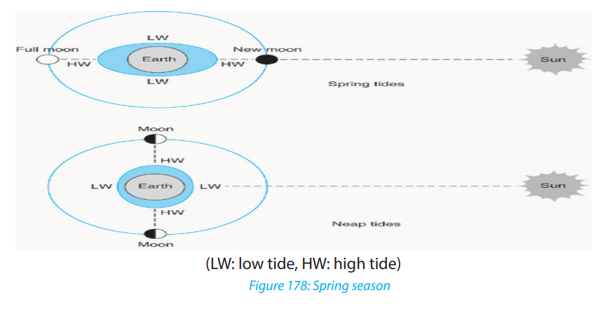
They are midway between the Spring tides. Neap tides occur when the sun, the earth
and the moon form a right angle with the earth at the apex. In this arrangement, the
Moon and Sun cause separate tidal bulges, affecting the water nearest to each of
them. In addition, the left-behind water resulting from the pull of the body on theopposite side augments each bulge.
iii. Tropical and equatorial tides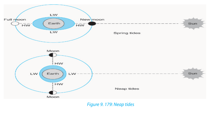
The position of the earth, the moon and the earth in straight line is called Syzygy.
When the sun, the moon and the earth are in sequential order in straight line, in
other words when the sun and the moon are in one side of the earth, the position
is called conjunction (the situation of solar eclipse). When the position of the earth
is in between the sun and the moon, this is called opposition. On the other hand,
when sun, the earth and the moon are in position of right angle, this position is
called quadrature. When there is maximum declination of the moon to the north of
Equator, the moon’s rays fall vertically on the tide centers and hence spring tides are
caused. Spring tides are also caused along the Tropic of Capricorn which is opposite
to the tropic of Cancer. These types of tides are also called tropical tides. When the
moon is at vertical position to the Equator (once per month) the tide caused is calledequatorial tide.
iv. Perigean Tides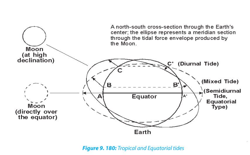
These are characterized by the high tides which are much higher than normal. They
occur when the moon is at its nearest point to the earth and thus its gravitational
effect is the greatest.
v. Apogean Tides
These are tides with a small tidal range. They occur when the moon is far away from
the earth. At this junction its gravitational effect is at the lowest point causing thehigh tide level to be lower than usual.
vi. Daily and semi-diurnal tides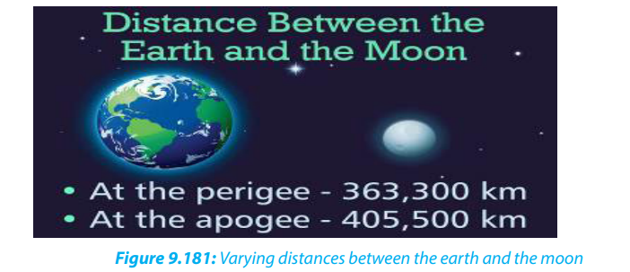
The tides recurring at the interval of 24 hours 52 minutes daily are called diurnal or
daily tides while the tides recurring at the interval of 12 hours 26 minutes are calledsemi-diurnal tides.
9.9.2. Causes and effects of tides
The origin of tides in the oceans is primarily concerned with the gravitational forces
of the earth and the moon. The earth rotates from west to east and revolves around
the sun following an elliptical orbit. Similarly, the moon rotates from west to east
and revolves around the earth along an elliptical orbit so that the distance between
the moon and the earth changes during different times in every month.
The gravitational force of the moon will be at its maximum at the earth’s surface facing
the moon, while it will be minimum at the opposite side of the earth. Consequently,
the water on the earth’s surface facing the moon is attracted and pulled and high
tides occur.
There are many effects of tides as explained below.• The daily rising and falling of the sea level generates tidal waves which can beApplication activity 9.9
harnessed to produce electricity. This is done at St. Malo in North West France.
• Tides generate strong and swift ebb and flood currents. The flow in and out of
bays through narrow inlets causes erosion.
• Tidal currents carry very fine silt and clay in suspension. These fine sediments
settle on the floor of bays and estuaries where they accumulate in layers and
gradually fill them up. This may silt up harbours hence hindering water transport.
• High tidal waves may flood coastal settlements leading to destruction ofproperty and loss of life.
1. Explain the relationship between tides and winds.2. Describe the effects of tides on lake shores of Rwanda
9.10. Reasons for protection of global water bodies
Learning activity 9.10:
Explain the importance of protecting water bodies?
Water is one of the most essential commodities apart from air but we tend to take it
for granted. That is why we don’t seem to have enough even though we have morethan we needed in our motherland.
The following are the major reasons for protection of global water bodies:
i. Economic uses: Water is needed by human beings for drinking, washing,
cooking, and for sanitation. The recommended basic requirement for
domestic purposes is about 50 litres a day. Thus, for a world population of
slightly more than 7 billion people, the total volume of freshwater needed
for domestic use annually is at least 110 x 109m3
ii. Agricultural use: The volume of water needed by agriculture to grow
the food to keep the population alive also must be added to this total.
Agricultural water needs are much greater than human consumption
needs, given that 600 and 1,800m3
is needed each year to grow the food
for one individual. Industry also uses large volumes of water. Including
hydropower, navigation and fishing, over 6,000 km3
of water are presently
used each year (estimates vary) for activities with economic considerations,
of which about 67% is used for irrigated agriculture and less than 3% for
domestic purposes.
iii. Recreational uses: Many freshwater bodies are used for sports activities,
boating, sightseeing, swimming, photography and other active or passive
recreational pursuits. They are also important for sports and commercial
fishing. Unfortunately, due to lack of knowledge about their impacts,
introducing fish from other places into a new environment lacking their
natural controls (e.g., predators, environmental conditions), has resulted
in some cases in the decimation of existing native fish species, while also
affecting entire local.
iv. Aesthetic values: Often termed ‘inspirational’ or ‘spiritual’ values, these
values are impossible to place a price on - indeed, there are some who say
these values are priceless! However, although difficult to quantify, such
values have long attracted the attention of poets, artists, writers and the
religious.
v. Cultural values: Many lakes and rivers have played a critical role in human
history, forming an integral part of our common cultural heritage. Religion
and socio-cultural values are part of the human existence. Also a beautiful
place for praying (Photo 5), they can facilitate lasting participation in
achieving the goal of integrated watershed management for sustainable
water use.
vi. Educational uses: As discrete, biologically-comprehensive and accessible
habitats, lakes, rivers and other bodies of inland water also represent unique
educational ‘tools’ for informing and educating the public.
vii. Scientific values: The biota and ecological processes of freshwater bodies
have long attracted attention from a number of scientific disciplines,
being the subject of countless investigations. Such investigations are very
important, primarily because they tell us how parts of the living world are
structured and how they function, as well as what the past was like, and
perhaps what the future may be.
viii. Ecological values: As integral parts of the global hydrologic cycle, pathways
for the circulation of essential elements, and repositories for a significant
fraction of the world’s biodiversity, freshwaters have an important ecological
role in sustaining the planet’s life-support systems. These so-called
‘ecosystem services’, like many other non-recognized-economic values, are
difficult to value economically, although studies are underway to develop
tools for assessing these services. One estimate is that the annual value of
ecosystem services provided by wetlands, lakes and rivers in the world areworth about US$ 6.6 trillion dollars.
Application activity 9.10
1. Discuss the ways you use to protect water at your school.
2. Visit a river or lake shore in your local environment and identify what thepeople around have done to protect it.
End unit assessment
1. Some ocean currents originate from warm regions and others from
cold regions. Describe the relationship between ocean currents and the
atmospheric circulation.
2. Conduct your own research to describe the major ocean management
projects in the world.
3. Discuss the economic advantages of drainage in Rwanda, and in the
world.
4. Explain the strategies to mitigate natural hazards associated with drainagesystem
UNIT 10: POWER AND ENERGY PRODUCTION IN THE WORLD
UNIT 10: POWER AND ENERGY PRODUCTION IN THE
WORLD
Key unit competence:
By the end of this unit, I should be able to evaluate the success of sustainable
development projects in power and energy production in different parts of theworld.
10.1. Sources and forms of energy used in the world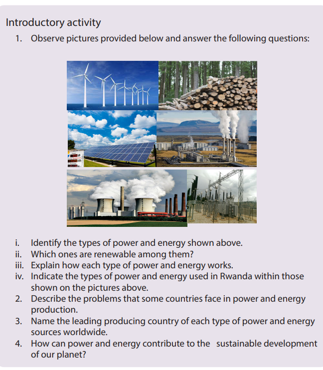
Learning activity 10.1
1. Make a short tour in the school and the surrounding environment and
answer the following questions:
i. Identify the activities that require power and energy at your school.
ii. Describe the forms of power and energy needed for each activity
identified above.
2. Discuss the sources of power and energy exploited and not exploited in
Rwanda.
10.1.1 Classification of energy resources
There are two main categories of energy resources:
• Non-renewable resources: These are resources of energy without the capacity
of replenishing themselves after being used. When used they get exhausted
and cannot be re-used. They include minerals, natural gas, oil and coal.
• Renewable resources: They are inexhaustible. These are resources of energy
with the capacity of replenishing themselves after being used. They include
water, wind, solar, plants (biomass) and animals (biogas).
10.1.2. Non-renewable energy sources
Non-renewable energy resources are available in limited supplies. This is usually due
to the long time it takes for them to be replenished. They include nuclear energy and
fossil fuels energy resources like coal, oil and natural gas.
a. Nuclear energy (Uranium)
Nuclear energy is energy obtained from uranium through a chain reaction. When
it was realized that when the nucleus of an atom is bombarded by electron it
disintegrates and releases enormous quantity of energy, two thoughts came in the
mind of rational man:
• to build an atomic weapon, and;
• to generate electricity.
Thus, mankind has developed the art of both. The release of energy by this process is
known as fission. Based on this process scientists build reactors in which controlled
fission went on to produce energy (heat) and this heat generated electricity.
Generation of electricity involves a lot of technical know-how and so far, only highly
developed countries have been able to master it. Thus, the USA, Canada, the UK,
France, Japan, Germany are the largest producers of electricity by nuclear fission.
Nuclear energy contributes about 9% of all energy produced in USA, though it
produces 50% of all electricity generated by nuclear energy worldwide. France
derives about 75% of its electricity from nuclear energy, 18.5% in Britain, 15% in
Japan and 7% in German. Among the developing countries India is the leader
producing 3% of her total requirements from nuclear power plants.
b. Coal
Coal is a sedimentary deposit formed by the slow action of heat and pressure on
plant remain buried in the long past. It is a mechanical mixture of carbon, hydrogen,
nitrogen, sulphur, etc. It is the content of carbon which determines the quality of
coal.
i. Types of coal
The amount of fixed carbon and hydrocarbons forms the basis of classification of
coal into various types. The following kinds of coal are generally recognized:
• Anthracite: It is a hard and dense coal which is relatively free from iron
compounds and moisture. It is made by 95 % of carbon.
• Bituminous: It is unusually black and highly lustrous. The moisture content is
relatively low. The fixed carbon content ranges from about 50 to over 80% and
that volatile matter from 40 to 15%.
• Lignite: It is also known as brown coal. The higher grades vary from dark
brown to almost black. It is characterized by high moisture content, generally
about 40%. The fixed carbon content is also 40%. The structure is fibrous, and
sometimes woody.
• Peat: It occurs in bogs, especially in areas of cool temperate climates. This isyoung coal which consists of partly decomposed vegetation.
ii. Uses of coal
The coal can be used:
• in thermal generators to produce thermal electricity.
• as a domestic fuel for heating and indirectly in the form of a gas and electricity.
• in iron smelting e.g. through use of metallurgical coke in blast furnaces.
• to provide a number of raw materials for the chemical industries like coal gas,
coal tar, benzele and sulphate of ammonia.
c. Petroleum (oil)
Petroleum is an inflammable mixture of oil hydrocarbons with very complex
properties. Petroleum literally means ‘rock oil.’ It exists underground in solid, liquid
and gaseous form. Accumulations of petroleum are found in underground fields,
pools or reservoirs of sedimentary rock formations.
i. Three grades of crude oil according to gasoline yields
• Paraffin - base oil has high percentage of methane (highest yields)
• Mixed-base oil has high percentage of naphthene (intermediate yields)
• Asphalt - base oil has heavier hydrocarbons (lowest yield)
ii. Uses of petroleum
Petroleum can be used:
• for heating homes and hearths;
• as industrial power to drive/move engines and for heating furnaces and
producing thermal electricity;
• as transport power for driving railways, motorcars, ships and aeroplanes;
• as lubricants of machines especially high-speed machines;
• as a raw material in various petro-chemicals industries, such as syntheticrubber, synthetic fibres, fertilizers, medicines.
d. Natural gas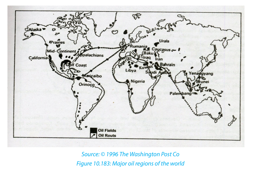
Natural gas is a naturally occurring hydrocarbon gas mixture consisting primarily of
methane, but commonly including varying amounts of other higher alkanes, and
sometimes a small percentage of carbon dioxide, nitrogen, hydrogen sulfide, or
helium.
The world’s proven reserves of natural gas are estimated at about 700 trillion cubic
feet. The USA (40%), the Middle East (23%), and the former USSR (11%). Most of the
rest is in northern Canada, Europe and Venezuela. Much smaller amounts are widely
scattered in several countries including Mexico, South American countries, Pakistan,
china, Indonesia and Australia. Nigeria is the first petroleum producing country in
Africa.
Natural gas may occur with or without petroleum. Where gas occurs in association
with oil, it is generally found in increasing amounts at the greater depths that needs
to be drilled.
Natural gas (Methane) as a fuel may be used for cooking, heating and even to
generate electricity. It has the advantage that it can be pumped through pipes from
wells to consumption sites. It is also a “clean fuel”. This means that it causes less air
pollution. Natural gas can be shipped in liquid form, called liquefied natural gas.
10.1.3. Renewable energy sources
Renewable energy is the energy that is generated from the resources that are
naturally replenished on a human timescale, such as sunlight, wind, rain, tides, waves
and geothermal heat. Renewable energy often provides energy in four important
areas: electricity generation, air and water heating or cooling, transportation and
rural energy services.
a. Wind energy
Wind power is an indirect form of solar energy that can be used to produce electricity.
Wind is an almost unlimited, free, renewable, clean and safe source of energy. It has a
moderate net useful energy yield and is based on fairly well developed technology.
As we can see it from the figure below, the process of the production of energy
from the wind is the following: usually a propeller blade is mounted on a tower. The
blade is connected onto an electric generator. As wind blows, the blade spins and
turns the generator which produces electricity by converting the kinetic energy of
the wind into electric energy. A suitable site for a wind turbine depends on the local
wind conditions.
b. Water energy
This is the energy produced from running water. Usually, a dam is constructed along
a river to store water. The water is then made to fall over a steep gradient. It then
passes through a turbine hence spinning the blades of the turbine. Rotation of theblades causes the turbine to turn an electric generator that produces electricity.
Hydro-electrical power energy requires the following physical and economic
conditions:
i. Physical conditions
• A seismological less sensitive area.
• High quantity of water supplied by fairly heavy rainfall distributed throughout
the year.
• Great altitude with steep slope to enhance water velocity.
• Existence of rapids and falls favour the development of power by increasing
the velocity of stream.
• Narrow steep-sided valley to facilitate dam construction.
• A hard rock for firm foundation.
• Existence of lakes or space for water reservoir.• The absence of coal, petroleum, etc., expedites the development of waterpower.
ii. Economic Conditions
• Market: Large demand for hydroelectric power;
• Huge capital outlay;
• Technological knowledge and skill and• Transport facility
c. Solar energy
Breeder reactors, fusion reactors and solar energy are the only energy alternatives
that could support high energy generation indefinitely. However, breeders have
potentially serious environmental and economic problems and nuclear fusion is so
complex, it can never be economically feasible. In contrast solar energy is abundant,
clean, safe and virtually inexhaustible free fuel.
If the direct sunlight falling on the earth in only 3 days is concentrated and converted
to useable form of energy, it would equal all of the energy in the earth’s known
reserves of coal, oil and natural gas.
The figure below shows the process of solar energy production. A greenhouse uses
panels of transparent glass to trap solar energy. Another way of tapping solar energyis by use of solar cells. This transforms sunlight directly into electricity.
d. Biomass
Many people consider the wind and the sun as the main forms of renewable energy.
However, biomass (plant material and animal waste) is the oldest source of renewable
energy, used since our ancestors learned the secret of fire.
Biomass is a renewable energy source for the two reasons: first the energy in it comes
from the sun, second, biomass can re-grow over a relatively short period of time
compared with the hundreds of millions of years that it took for fossil fuels to form.
The generation of energy starts through the process of photosynthesis. Through this
process, chlorophyll in plants captures the sun’s energy by converting carbon dioxide
from the air and water from the ground into carbohydrates—complex compounds
composed of carbon, hydrogen, and oxygen. When these carbohydrates are burned,
they turn back into carbon dioxide and water and release the energy they captured
from the sun.Bio-mass energy includes: wood fuel, Bio-gas and Gasohol.
i. Wood fuel: This is a very important source of energy in third world
countries. The wood obtained from forests is either used directly or
converted to charcoal.
ii. Waste products (Bio-gas): This is a flammable gas produced by microorganisms, when organic matter is fermented under specific temperatures,
moisture content and acidity. It is mainly composed of methane which
burns with a blue flame.
iii. Gasohol: Plant material may be converted to alcohol which is a fuel.
Wood, wood wastes and garbage can be heated to produce methanol.
Most plants containing starch and sugar like sugarcane and cassava can
be converted to ethanol. Corn, corn stalks, manure and sewerage can be
fermented and distilled to give ethanol. Both methanol and ethanol are
directly burned as a fuel.
e. Geothermal
Geothermal energy is produced when rocks lying deep below the earth’s surface are
heated to high temperatures by energy from the decay of the radioactive elements
in the earth and from magma. Geothermal energy can be considered as renewable
source of energy if deep underground heat flows can be tapped.
Geothermal energy can either be used for heating water, directly and space heating
needs in agriculture and for domestic purposes or it can be converted into electricity.
i. Wood fuel: This is a very important source of energy in third world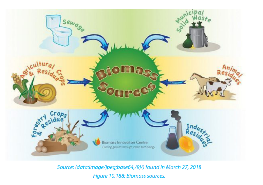
countries. The wood obtained from forests is either used directly or
converted to charcoal.
ii. Waste products (Bio-gas): This is a flammable gas produced
by microorganisms, when organic matter is fermented under specific temperatures,
moisture content and acidity. It is mainly composed of methane which
burns with a blue flame.
iii. Gasohol: Plant material may be converted to alcohol which is a fuel.
Wood, wood wastes and garbage can be heated to produce methanol.
Most plants containing starch and sugar like sugarcane and cassava can
be converted to ethanol. Corn, corn stalks, manure and sewerage can be
fermented and distilled to give ethanol. Both methanol and ethanol are
directly burned as a fuel.
e. Geothermal
Geothermal energy is produced when rocks lying deep below the earth’s surface are
heated to high temperatures by energy from the decay of the radioactive elements
in the earth and from magma. Geothermal energy can be considered as renewable
source of energy if deep underground heat flows can be tapped.
Geothermal energy can either be used for heating water, directly and space heatingneeds in agriculture and for domestic purposes or it can be converted into electricity.
f. Tidal energy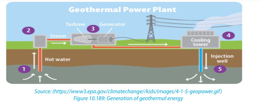
Tidal energy or tidal power is a form of hydropower that converts the energy
obtained from tides into useful forms of power, mainly electricity. Although not yet
widely used, tidal energy has potential for future electricity generation.
As the tide rises and falls water flows into and out of bays and estuaries. If the bays
and the estuaries can be closed by a dam the energy in the tidal flow can be extracted
four times a day and used to spin a turbine to produce electricity.
Although all coastal areas are subject to some tidal changes, only those few areas
with a large enough tidal range of some four to five meters are potential sites for tidal
power plants. These sites are located for most part on both sides of North Atlantic,
the English Channel and the Arctic coast of the C.I.S. a few developing countries
such as Argentina and India also have some tidal power potential.
There are presently two tidal power projects: one in Commonwealth of IndependentStates (C.I.S) and the other in France.
Application activity10.1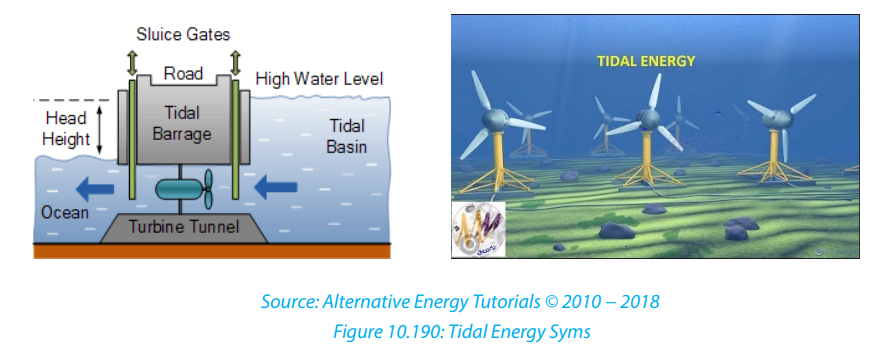
i. Describe the sources of power and energy exploited in Rwanda.
ii. Indicate the main hydro-electric power stations in Rwanda.
iii. Suggest other alternative sources of power and energy that can be used in
the world.
iv. What types of energy sources promote environmental sustainability?
10.2. Factors and importance of power and energy production in the
world
Learning activity 10. 2
1. Describe the areas of power and energy production in Rwanda and
showing the reasons of their geographical location.
2. What are the challenges that Rwandans would be facing if those areasidentified above were not there?
10.2.1 Factors favouring power and energy production in the world
The following are the major factors influencing power and energy production in the
world:
• Availability of market is a pre-requisite for the power and energy production.
For example, densely populated areas, industrially and commercially advanced,
have a great demand for electricity.
• Availability of capital to invest in power and energy production. Production of
energy/power, setting up power houses, and transmitting electricity through
wires to the areas of consumption require a lot of capital in terms of money.
• A high degree of technical knowledge and skills.
• The amount of energy to be produced depends on the potentiality of power
and energy generator. For example, the amount of hydro-electrical power to
be produced depends on the quantity of water and velocity of stream. The
latter, in turn, depends upon the gradient of the stream.
• The natural environment of the area where the power and energy will be
produced and transported such as the topography (e.g. nature of terrain and
slope), climate (e.g. amount of rainfall, sunshine), hydrology (e.g. quantity and
quality of water), vegetation (e.g. amount of biomass) affect the production ofpower and energy.
10.2.2. Importance of power and energy in the development of the world
Power plays a role in the development of a country in different ways such as:
• Earns foreign exchange: Energy can be exported in neighboring country
and in that way, it is contributing to the earning of foreign exchange. The
economies of many countries are depending on the production of petroleum
which is the most used worldwide source of energy. For example, the DRC
earns $40 million annually through exports of electricity from Inga dam plant.
• Development of industrial sector: The engine that moves the industrial sector
is energy and without it the whole sector would ground to a standstill. Most
industries use petroleum and its by-products to run the machines. Electricity
is also used to run machines while wood fuel is used in various processing
industries such as tea processing.
• Development of transport sector: Petroleum is used in road transport, water
transport and air transport meaning that it is the basic element in transport.
• Creation of employment opportunities: The generation of electricity is
offering employment to a good number of people.
• Development of Agricultural sector: Solar energy is used to dry grains and
other produce such as tobacco, cocoa and coffee. Petroleum and its products
are used to run water pumps and other agricultural machinery. Wind power is
used in dry regions to pump water for irrigation.
• Improvement of welfare of people in general: Various forms of energy is
used for various purposes such as cooking, lighting and heating. In the rural
areas, the main sources of energy are firewood, charcoal and liquid petroleum.
In Urban sector, charcoal, kerosene, liquid petroleum, gas and electricity are
used.
Application activity 10.2
1. Describe requirements for Rwanda to fully exploit its available power and
energy resources.
2. Visit your local industrial areas and identify the role of power and energy
in an industry.
10.3. Problems and possible solutions for power and energy
Learning activity10.3
Visit a power station in your environment and do the following:
i. Identify the problems of power productionii. Suggest the possible solutions to the identified problems.
10.3.1 Problems hindering the development of power and energy in the world
The energy crisis is still experienced in different parts of the world. This is due to the
following reasons:
• Coal has some inherent problems. Petroleum is not going to last long.
Hydroelectricity has its own limits and nuclear energy has some political
problems for it to be socially accepted worldwide because of the risks of its
catastrophes.• Overdependence on oil and its products. Many countries rely on petroleum10.3.2 Possible solutions for power and energy in the world
and petroleum products in industrial, transport and agricultural sectors. It
therefore becomes quite difficult to switch to other sources when there is a
problem with the supply of oil.
• Economic and political embargoes fixed by the rich countries. For example, in
1973 the oil producing countries in the Middle East imposed oil embargo on
USA because of its interference in the Israel and Palestine war.
• Increase in oil prices imposed by the Oil Producing and Exporting Countries
(OPEC).
• Depletion of wood fuel due to overexploitation of forests.
• Exhaustion and deepening of coal mines. Coal is a non-renewable source
of energy. Its continuous use leads to the deepening of the mines hence its
exhaustion. Consequently, the cost of extraction increases leading to high
prices of coal in the world market.
• Environmental pollution: Some sources of energy like coal and petroleum
are sources of Carbon dioxide which is emitted in atmosphere. The increase
of carbon dioxide in atmosphere leads to ozone layer depletion and climatechange with their consequences.
As the energy is used at a very high rate and people will continue to do so in the
future, there is no doubt that it will be exhausted one day. Since our energy resources
are limited, certainly there is a need to do something about it like:• Move towards renewable resources: The best possible solution is to reduceApplication activity 10.3
the world’s dependence on non-renewable resources and to improve overall
conservation efforts. Much of the industrial age was created using fossil
fuels, but there is also known technology that uses other types of renewable
energies – such as steam, solar and wind. The major concern is not so much
that we will run out of gas or oil, but that the use of coal is going to continue to
pollute the atmosphere and destroy other natural resources.
• Buy Energy Efficient products: Replace traditional bulbs with fluorescent
tube lights CFL’s and light emitting diode (LED’s). They use less watts of
electricity and last longer. If millions of people across the globe use LED’s and
CFL’s for residential and commercial purposes, the demand for energy can go
down and an energy crisis can be averted.
• Energy Simulation: Energy simulation software can be used by big corporates
and corporations to redesign building unit and reduce running business
energy cost. Engineers, architects and designers could use this design to come
with most energy efficient building and reduce carbon footprint.
• Government may come in and improve on public transport efficiency so as to
reduce the need to use personal vehicles to reduce the use of petroleum.
• On the domestic front, energy conservation can be achieved by making
electrical appliances like refrigerators, television, electric cookers more energy
efficient. This can be supplemented by switching of electricity gadgets when
not in use.
• Educating the public about the importance, the conservation and thesustainable use of energy resources.
This is an extract of an interview with Wilson Karegeya, a firm’s director for
commercial services, Rwanda Energy Group held with iPAD Rwanda Power &
Infrastructure Investment Forum in Kigali.
This interview was conducted two months before splitting EWSA into WASACand REG. Read it carefully and answer the questions related to it.
Let’s start with an update on the reform of the energy and water organisations
in Rwanda.
Rwanda Energy Group today was still EWSA two months ago. EWSA was the Energy,
Water and Sanitation Authority, a government parastatal, which they thought
splitting the organisation would ensure more efficiency, better and quick service
delivery. So it was split two months ago,
forming two corporations: one for water, the Water and Sanitation Corporation,
headed by a Managing Director. It was a department in EWSA and is now a standalone
company and still 100% owned by government. There is also the Rwanda Energy
Group (REG), which will specifically deal with energy projects. REG also has two
subsidiaries, the Energy Development Corporation Ltd and the Utility Corporation.
The Energy Development Corporation will mainly
What do you hope to achieve in the next 12 months?
We have now embarked on asset separation; EWSA had a lot of assets that need
to be shared between the water company and the electricity company. There are
issues of accounts and fixed assets like land and buildings that need to be split and
shared. That is what the new companies are doing right now. We are being assisted
by Price Waterhouse and some other specialised companies to make sure the reform
is done well for better service delivery.
And we expect, of course, more specialisation for these companies. The water
company will now specialise in making sure that they deliver clean water to the
population. They will be less distracted because they will be mainly focused on
providing clean water. And the electricity company will now not be overstretched,
looking into water and electricity but looking specifically into electricity projects,
so I expect more focus for these companies that will lead to better service delivery.
The energy projects that you will invest in, can you highlight specific challenges
and how
you will overcome them? One challenge is that we were used to government
investments where government invests in energy projects. We have now adopted
an approach to involve the private sector more in the generation phase of it: where
we identify projects that need to be developed, advertise them, attract private
investors, (IPPs) and negotiate the power purchase agreements with them, once we
agree and sign the contract, the project is up and running. Where I see challenges
is in the contract management. It is an issue that we are not used to working with
IPPs. Although you sign a PPA with an independent power producer, it is more about
managing the contract from day one up to the last day of the contract. So that is a
challenge there but we hope to overcome it by training our staff to make sure they
know how to deal with IPPs, know what to expect and when and what the IPP has todeliver. That is very important.
In terms of generation capacity in Rwanda, what is currently available and how
much are you projecting?
Currently we are at 110 megawatts capacity and we expect to generate up to 563
megawatts by 2017. That is the target we have. There are on-going projects that will
enable us achieve this targeted megawatts and some are nearing completion. We
have also taken the direction of utilising the regional interconnectors to be able to
share power with the neighbouring countries. We are currently negotiating a PPA
with Kenya aiming at purchasing power from Kenya through Uganda.
Power generation goes hand in hand with other infrastructure development
such as roads, rail etc. what are the plans there?
In the transmission sector we have also started using private developers. We recently
advertised a tender to attract investors to come and do the transmission lines and
improve the networks as we expand the capacity. Of course, there is a need to
improve the network, so we are doing that concurrently. What is a day like in Rwanda
in terms of electricity supply? Until recently there weren‘t many power outages in
Rwanda. But now industry is growing and the demand for energy is growing and
we are striving every day to increase the capacity to serve all our customers, be it
investors, industrial or domestic. Of course, you get investors who come to us saying
―I want 5 megawatts, I want 15 megawatts, I want up to 10 megawatts‖, so you
have to work hard to make sure you use all the resources available to provide such
electricity.
A recent example is a new cement factory that has asked for up 15 megawatts,
and we have a total capacity of 110 megawatts for the whole country. So you can
imagine how hard we have to work. The good news is that we have secured the
power the factory requires.
Who looks at tariffs and the regulation around tariffs?
It is RURA (the Rwanda Utility Regulatory Agency). But if we are attracting investors
for projects above 5MW, we negotiate a tariff. For projects below 5 megawatts, there
is a feed in tariff set by RURA. For big projects, Rwanda Energy Group negotiates
with the developer and agrees a tariff at which it will supply electricity.
What is the situation with residential access to power?
For now, the residential users are connected and satisfied. The challenge we are
facing is the new industries that are emerging. Otherwise the domestic customers
had no issues so far. Perhaps they might have to start competing for the insufficient
power that we have – to share this among the commercial and domestic clients that
we have. But we are working very hard to bridge the demand gap that is growingday by day
What do you see happening in the East African region in the next five years?
My personal view is that if the current trend of cooperation among the East African
member States continues, I see success. When I look at the engagement between
member countries, sharing power, that is success. When I see the opening of borders
for trade, that is success, and opening of borders for human capital, that is success. Ifthis trend is maintained I see a powerful East African Community.
Extracted from: ESRI AFRICA: AFRICA‘S POWER JOURNAL, Published on September 10, 2014
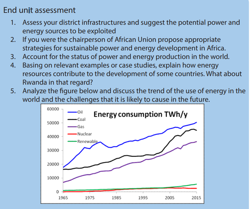
UNIT 11 INDUSTRIALIZATION IN THE WORLD
UNIT 11: INDUSTRIALIZATION IN THE WORLD11.1.1. Definition of industry
Key unit competence:
By the end of this unit, I should be able to evaluate the success of sustainable
development projects in the industry in different parts of the world.
Introductory activity:
Mr. Gatete is a farmer, he grows crops like coffee, cotton, bananas and
fruits and rears cows and goats. He sells both crops and animal products to
Amahoro Cooperative Society which transforms these products into Juice,
Packed milk, Cheese, Clothes etc.1. According to you, in which category of industry does Mr. Gatete belongto?2. Explain the factors on which Amahoro Cooperative Society base onto establish the factory which transforms Gatete’s products and theproblems that may be associated with the factory.3. Make research on internet and find out five examples of moreindustrialized countries in the world and describe the factors for their11.1. Definition, classification of industries, factors influencing locationindustrial development.
of industries and major industrial regions of the world
Learning activity 11.1
Use experience from your local environment and answer the following
questions:
1. Identify the categories of industries observed.
2. Describe the factors that influenced their location.
An industry is an establishment that involves production of goods and offering of
services. It also refers to the processing of raw materials into finished goods.
Industrialization refers to the concentration or to the development of industries inan area, country or region.
11.1.2. Classification of industries
There are three categories of industries which are closely interrelated.
• Primary / Extractive industries
These are industries which produce raw materials. They are concerned with the
extraction of natural resources. They involve agriculture, forestry, mining and fishing.
• Secondary / Manufacturing industries
These are industries that transform raw materials into finished products suitable for
consumption. They include food, beverages, chemical products, etc.
They are subdivided into two categories:
- Heavy industries: Such as engineering, metal goods, chemical, ship building
industries, etc.
- Light industries: Such as food processing, plastics, textiles, electrical equipment,
cosmetics and toilet articles etc.
• The tertiary / Service industries
These are industries involved in the provision of services. The tertiary industries do
not produce goods but provide backup services to the industrial sector. The services
provided include transport and communication, trade and commerce, financialinsurance, printing and publishing, education, health, banking, etc.
11.1.3. Factors influencing the location of industries and industrial
development
There are several factors, including physical, economic, political; historical that
influence the location of an industry. A brief description of these factors is shown
below:• Efficient labor: An adequate or skilled labor force is essential in the initiation
and continuance of an industry. It gives the company a maximum output with
lowest possible costs.
• Power and energy: Any industrial establishment must be located in the areas
with enough fuel or other sources of energy.
• Land: The location of any industry requires extensive land for set up and future
extension.
• Government policy: Government’s policy of encouraging industries is also
an important factor. This can be done through tax reduction, giving land
and energy to investors to establish industries in the areas. This is done foreconomic and political reasons e.g. job creation and regional balance.
.Raw materials: Raw materials in their different forms are important in the
location of industries. Therefore, the availability, the value, size, quantity,
quality, weight and proximity of the raw materials are essential requirements
for industrial location.
• Transport and communication: Modern industries require constant supplies
of raw materials, often in great bulk from various sources. Finished goods have
to be distributed to many places also. Thus the availability of a good network
of transport facilities is another important factor in the location of industries.
• Market: There is a very strong justification for industries to be located near
the markets which consume their finished products. Some types of industries
are more likely to be located near markets than others; e.g. perishable goods,
fragile goods, bulky goods etc.
• Capital: No industry can be developed unless it has financial support. The
finance may be provided by private investors, large companies, or by the
government. Capital is required in every phase of industrial development.
Money is required for the purchase of the land , construction of factories,
purchase of machines, acquisition of the required raw materials, transportation
of both raw materials and finished goods and for the payment of wages,
marketing, advertisement, etc.
• Water supply: Certain industries, especially iron and steel, aluminum smelting,
thermal power generation, pulping of timber, synthetic fibre manufacture and
chemicals, consume enormous quantities of water either in processing the
raw materials or for cooling purposes.
• Industrial inertia: This is when an industry remains in its original location even
if the initial advantage that led to its location is no longer available. This is due
to three main factors:
The presence of a good transportation network of roads, railways,
canals and so on. An industry moving to a new site might face
transportation difficulties.
Influence of skilled labor and experienced workers built up in that
area.
The cost of building and equipping a factory is extremely high.Industrial establishments do not readily undertake a complete move
with the new building and tooling-up costs that this entails.• Sites: Some industrial plants have to be sited on leveled ground instead of hilly
regions. Others require vast acreage of land and the cheapness of the available
land is a primary consideration.
• Climate: Climatic factors sometimes have to be taken into account especially
in countries with extremes of climate. Costs of heating, air conditioning
factories or offices may be prohibitive. Hot climate may create problems of
storage. Climatic factors such as severe winters or annual floods may affecttransportation adversely.
• Political stability: encourages long term investment necessary for industrial11.1.4. Major world industrial regions
development. This is why countries with little political instability like Western
Europe are advanced in industrial development than developing countries ofAfrica and Asia.
There are major industrial areas in both developed and developing countries. Japan,
USA, and Russia are the example of industrialized countries in developed countries,
Egypt, South Africa, China and South Korea in developing countries.
Application activity 11.1:1. Describe the categories of industries common in Rwanda.11.2. Importance of industries and problems affecting industrial
2. Visit the industries located in your area and describe the factors that led to
their location..
development
Learning activity 11.2
According to you, why is it important for a country to have industries?
11.2.1. Importance of industries
Industries have the following advantages:• Industries provide self-sufficiency in essential goods rather than the need for
imports and dependency on foreign aid. In other words, it causes import
substitution and export promotion, which encourages development.
• Self-sufficiency gives greater political and economic strength. It makes a
country more independent of foreign political or economic domination.
• It creates employment. It employs both skilled and unskilled labor.
• Industrialization earns the country foreign exchange. If the products are
manufactured for export, the value of the commodities is increased and so the
revenue obtained from their sale also increases.
• Industrialization raises living standards of the population as they contribute toincrease their income.
• It contributes to the diversification of the economy and reduces reliance on11.2.2. Problems affecting industrial development
agricultural products which may fluctuate in prices.
• Industrial growth is cumulative and can stimulate growth in other sectors of
the economy.
• It provides infrastructure particularly electricity, transport and communication.
• Industries also improve social amenities like schools and hospitals.
• It contributes to the development of research and technology and the regular
training of skilled man power.
There are several problems that affect many industries. Below are the main and
common ones:• Inaccessibility to the distant world markets which results into low demand forApplication activity11.2:
the manufactured goods especially in landlocked countries.
• Lack of real capital investment. Many countries have a problem of inadequate
funds to set up industries.
• Shortage of unskilled, semi-skilled and skilled labor. Inadequate managerial
and entrepreneurship skills have also affected industrial growth.
• Lack of adequate supporting infrastructure. This is critical for the development
of industrial activity.
• Developed countries face the twin challenges of reduced demand and
increased unemployment levels in older industries as well as finding new
market for their industrial output.
• Competition for markets has led to blocks of countries grouping to reduce
trade barriers and to increase integration of supply and demand. Such trade
agreements allow individual countries to take advantage of agglomeration
economies and cheap labor among themselves. However, for countries outside
the trading block, they act as barriers to trade and tariffs.
• The infrastructural facilities in the developing countries are not at the level
necessary to produce and support industrialization.
• The shortage of valuable minerals in some countries, such as iron ore which
form a basis for the establishment of industries. These countries have to import
raw materials at high costs.
• In developing countries, poverty lead to a low demand for industrial goodsresulting into a limited market, thus affecting the process of industrialization.
Explain why the industries in developed countries are highly developed than
the ones in developing countries.
11.3. Problems resulting from industrial development and ways to
mitigate them
Learning activity 11.3
Why is it not advisable to live near industrial areas?
Industrial development has both positive and negative effects on a given country.• Pollution of the environment: In the areas of heavy industrial concentration,
land, air and water are contaminated by industrial wastes.
• Wildlife Extinction: Industrial pollution affects habitats of wildlife and destroys
its species; it is hard to recover them in the environment. For instance, major
industrial accidents like oil spills, fires, leak of radioactive materials cause great
damages.
• Global Warming: With the rise in industrial pollution, global warming has been
increasing at a steady pace. Smoke and greenhouse gases are being released
by industries into the air and this contributes to global warming. Melting of
glaciers, existence of floods, tsunamis, hurricanes are some of the effects of
global warming.
• The accidents caused by the machines used in industries: The machines used
in industries for various purposes may cause the accidents from the misuses
by the employees or from other external causes; e.g. Lightening, tsunami,
electricity, collapses of mining tunnels, etc.
• Leaching of resources from the environment: Industries do require large
amount of raw materials to process into finished products. This requires
extraction of minerals from beneath the earth. The extracted minerals can
cause the environment destruction in different ways.
Ways to mitigate the problems caused by industries
- Isolation of industries from settlements and sources of water to reduce the
effects of pollution.
- Reducing of greenhouse effects through neutralizing industrial fumes before
they are disposed into either air or water.- Efforts should be made to control pollution. These can take the form ofApplication activity 11.3:
industries treating their wastes before disposing them as well as recycling
some of those waste products and the use of biodegradable materials.
- Promotion of training skilled manpower and use of appropriate technology to
reduce accidents in industries.
- Creation of special areas/ zones where industrial wastes are channeled or
poured.
Examine the ways of reducing problems caused by industries in developing
countries.
11.4. Case studies on major industrial regions in the world
Learning activity 11.4
Make research and identify the major world industrial regions.
11.4.1. Developed countries
a. Industrialization in USA
i. Factors for the high level of industrialization in USA
USA is the world’s leading industrial nation. About four-fifth of the industrial
output of North America is contributed by the United States alone. The factors,
which helped in the industrial development of USA, are:• A wide range of raw materials such as agricultural raw materials and mineralii. Industrial regions of USA
raw materials.
• The population of USA was made up of immigrant from many advanced
European countries especially from U.K, France, Germany, Holland and others.
These immigrants brought with them the experience skills and technical
knowhow of their mother countries. This encouraged rapid industrial
development.
• USA is located on the opposite side of Atlantic from Europe. This has stimulated
trade and growing world markets. It has also led to industrial expansion.
• USA has extended water transport from St. Lawrence Seaway to the heart of
Geography Senior Six Student Book 309the continent via the Great Lakes. This has stimulated industrial developmentby providing cheap means of transport for raw materials and finished goods.• USA has a high level of technology. This has been maintained by adequateeducational and training facilities and a technological system. This systemattracts skilled scientists and technologists. This brain gain helps to give theUSA a lead in scientific modern industries such as electronics computers andso on.• USA has abundant petroleum, natural gas, local and hydro-electric power. Theavailability of various sources of power in economic quantities has stimulatedthe development of large manufacturing industries.• Availability of capital generated from international trade (from exports)encouraged industrialization.• The government of USA also encourages rapid industrialization. It encouragesexport promotion.• There is internal competition among the industries and this has stimulatedindustrial development.• Availability of extensive land for industrial development.
There are six industrial regions in USA:1. Southern New England: It is centered in Boston with two types of industries;Major industrial regions of USA
shipbuilding and textile,
2. Mid-Atlantic States: This region includes cities of New York, Philadelphia and
Baltimore. The industries here include iron and steel, engineering, printing,
electrical goods, foot wear and consumer goods.
3. Pittsburgh – Lake Erie region:this is the core of heavy industries, engineering,
glass, pottery, chemicals, synthetic, rubber, tyre making, generating
hydroelectric power from Niagara Falls, flour milling etc.
4. Detroit industrial region: this is the greatest automobile manufacturing
region of the USA. Other industries include electrical wires, glass, batteries,
paints, alloyed steel etc…
5. South Appalachian region: It is centered in Birmingham. Industries include
steel making, Hydro Electric Power generation, cotton textiles, metal works,
machinery manufacture etc.
6. Eastern Texas: It has major cities like Dallas, Fort Worth and Houston. Thisregion is the major USA source of oil and gas.
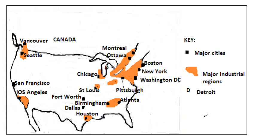 b. Industrial development in Japani. Factors for high level of industrialization in JapanJapan is the most highly industrialized country of Asia and ranks among the mainindustrial nations of the world. Despite its shortage of industrial raw materials,Japan has been able to develop her industries because of the following reasons:• Development of hydro – electric power resources to provide enough power tosupport rapid industrial development because of little quantity of coal.• Efficient use of its limited raw materials such as copper, manganese, iron ore,sulphur and timber.• The coastline and many large ports facilitate the importation of large quantitiesof raw materials from all over the world. This is because of the geographicallocation of Japan.• The population that provides a large supply of labor and the development ofindustries since it has small land for agriculture.• The government that encourages industrial development. It has formulateda technically based education system. This has improved the country’stechnological development• A high and expanding market potential. It is located near Asian countrieswhich are mainly agricultural dependent. These provide market for Japanesegoods• Aid from USA: after the Second World War, Japanese industrial establishmentswere destroyed. It got financial assistance from rich countries specifically theUSA. These loans were used to replace and rebuild the ruined industries• Advanced technology: Japan adapted latest techniques from Westernindustries and have been able to improve upon them• Improved transport network: water transport, modern ports were build, roadsand railways were improved.ii. The Major industrial regions of JapanJapan is the most industrialized country in Asia and ranks among the industrialnations of the world. There are four main industrial zones in Japan:• The Keihin Region: This is the most industrial region in Japan located onthe Kwanto plain to the East of HONSHU. It is formed by the conurbationof three important towns; Tokyo, Kawasaki, and Yokohama. This regionhas 20 % of the Japan’s population and account for 33 % of the country’soutput. The major industries found in this region are Chemicals, machinery,textiles, food processing, furniture. Each town in the region specializesin a particular item. Tokyo is noted for electrical engineering (especiallyTelevision sets, refrigerators, washing machines and computers.)Yokohama has precision engineering, shipbuilding, oil refining, petrochemicalproducts and port industries. Kawasaki is renowned for marine engineering,cement works and glassworks. The manufacture of iron and steel products iscentered on Chiba.• The Hanshin Region: this stretches across a great industrial conurbation ofthree major cities formed by Osaka, Kobe and Kyoto. It accounts for about 20% of Japan’s industrial output. It is important for the manufacture of textile,iron, and steel products, handcrafts, and shipbuilding. Osaka is the greatesttextile industry. Plastics, footwear and textiles machines are also made. Kobeconcentrates on shipbuilding, oil refining, and petrochemical industries. Kyotois important for the manufacture of crafts, toys, and oriental (Asiatic) ware.• The Ise Bay Region: this is the third industrial region dominated by NAGOYAindustrial Region on the Nobi Plain with a wide range of manufacturingindustries including textile mills that process local silk, imported cotton ,wood and also synthetic fibres ; engineering industries including all kindsof machinery , automobiles ,locomotives and aircraft . The nearby towns ofTajimi and Seto are noted for musical instruments such as guitars, violins andpianos are mass-produced at Hamamatsu.• The Kitakyushu Region: in the northern Kyushu area, the Chikugo coalfieldand good accessibility gave rise to a conurbation, called Kitakyushu. This one,embraces several towns, including Yawata, Kokura and Moji. The industrial areaextends southwards to Fukuoka and Nagasaki. It makes steel, ships, machineparts, chemicals and textiles.Apart from the above four major industrial regions, there are several scatteredindustrial towns. Iron and steel are made at Muroran, oil refining is important atAkita and Niigata, engineering at Hiroshima, shipbuilding at Kure, and textiles atOkoyama, Hakodate and Sapporo in Hokkaido are also industrially developed.Major industrial regions of Japan
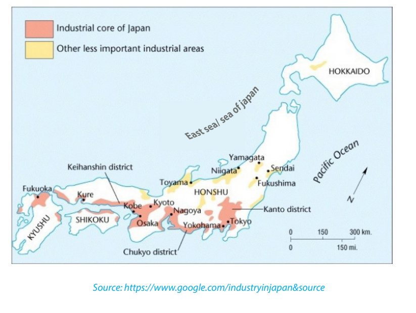 c. Industrialization in Russia11.4.2. Developing countries
i. Factors for high level of industrialization in Russia• Presence of a variety of minerals such as Iron, copper, gold, diamond, coal etc.• Improved transport network of railways, aircrafts and developed road network.• Existence of agricultural raw materials such as cotton for textiles, milk fordairies, hides and skins for leather and footwear industries.• Availability of capital from financial institutions to promote industrialii. Industrial regions of RUSSIA
development.
• Improved research to develop cheap and highly efficient methods of
production. This has led to technology and industrial development.
• Government policy of promoting self-sufficiency in most of the manufactured
goods consumed in the country.
• Attraction of foreign investors from Europe, Japan and USA has greatly
contributed to industrial development.
• Presence of a large population which provide a large domestic market and
cheap labor force.
• Skilled labor in form of electrical, mechanical, chemical engineers, laboratory
assistance.
The Russian industries are concentrated in the four major areas:1. The Moscow – Gorki region: this region has diverse industries including
heavy engineering, steel industries, railways, equipment, automobiles,
aircraft and food processing.
2. The Ukraine industrial region: This region has developed during the period
of USSR (Union of Soviet Socialist Republics) the main industries are iron
and steel, making machinery, chemicals, etc.
3. The Urals industrial region: engineering (heavy) and metallurgical industries
dominate all other activities,
4. The Kuzbas region: This area has large thermal plants, extensive coal
deposits, engineering, hydro-electric power plants, metallurgical plants,
chemicals including petrochemicals.Major industrial regions of Russia
a. Industrial development in ChinaIndustrial development in China began after the beginning of Communist rule in
1949, and now China is an art industrial power of Asia and of the world. There has
been a complete transformation of the industrial system during the last 60 years.
Under the new system and policy, China is developing its industrial system in a
planned manner. Rapid development has made China a leading producer of iron
and steel, textiles, and cheap consumer goods such as toys, household goods and
light metal goods.
i. Factors for industrial development in China
• Large quantities of natural resources: They constitute the raw materialsfor industries such as coal, copper, zinc, lead, and manganese. This has given rise to
industries dealing in copper processing, steel products, electrical equipment
etc.
• Deposits of coal and petroleum: They act as a source of energy for the industries.Coal is the single most important energy source.
• Large population: With over 1.3 billion people,China has large domestic market for its industrial goods.Chinese manufactured goods have a ready market
even in other countries like USA, Japan, UK, and the European union.
Geography Senior Six Student Book 315
• Location of China: On the Asian main land and the most populated continentprovides the market for manufactured goods, the promotion oftrade and procurement of raw materials.• Government policies: Communist system has great influence onthe development of industries where each commune was encouragedto have its own industries.• Education: Chinese system provides the basic skills on practical knowledgerequired in industries and workshops.• Cheap labor force: With a large population, China has a big labor force which ischeap, skilled and unskilled. China has a largest labor force in the whole world.• Transport and communication systems: Aircraft is developed to communicatewith the entire world and railway transport is improved for acquisition of rawmaterials and distribution of manufactured goods. Also the country has navigableinland water ways but has been improved by construction of canals.ii. Industrial regions of China• Manchurian Industrial Region: This is the most important industrial area of
China with centers at Anshan (steel industry), Penki (steel industry), Fushun
(coal, lubricating oil, and chemicals), Mukden or Shenyang (machinery and
tools) and Dairen (mills and shipyards). All of them are nearby coal and iron ore
deposits. Anshan, Fushun and Shenyang form a triangle, within which there
are numerous large plants.
• Tientsin and Beijing Region: This is a second industrial area located at the
northern end of the North China Plain, near the Kailan coal reserves, with
Tientsin, Peking or Beijing and Tangshan as its main centers. The presence of
coal-fields in Shansi and Hopei has contributed to the rise of the metallurgical
and engineering industries here.
• Lower Yangtze Industrial Region: This is China’s oldest industrial region.It existed since the middle of 19th century. Shanghai is the main industrial town
and port of this industrial region. The main goods produced are cotton, silk,
textile, food, leather, radio, television sets, utensils, leather, etc. There are also
shipyards, oil refineries, flour mills, steel plants, metal works and a great variety
of light industrial products.
• The Middle Yangtze Industrial Region: It is located on the middle Yangtze plain
around the former tree towns of Hankow-Hanyang-Wuhan. There iron and
steel works there that are based on Peninsiang coal and Tayeh iron ore.Shipbuilding, metallurgical and heavy industries, railway equipment andchemicals are important items of production.• Sichuan (Szechwan) Industrial Region: Sichuan (Szechwan) province above
the Chang Jian (Yangtze Kiang) gorge has many important industries around
Chongqing (Chungking) and Chengdu (Chengtu).The rich deposits of coal,
iron, Ferro-alloys and abundant agricultural raw materials have all encouraged
industrial development. Iron and steel, textiles, paper and pulp, machinery,
cement, and chemicals are made here.
• Si Kiang Delta Region: The port of Canton is the main industrial centre at the
mouth of the Xi Jiang (Si Kiang). Canton lacks local raw materials and once
was known largely for commerce. Modern industries are centered on silk production;there are silk mills, jute and cotton goods are manufactured, rubberIn China, many cities are considered to be the industrial cities. Some towns such as
is processed, and there are food-canning and match factories. Iron works andmachine factories occupy sites near the docks.
Anning, Kiuchuan (iron and steel); Yumen and Hangzhou or Hangchow (oil refining);
Lanzhou or Lanchow (chemicals, textiles, mining equipment) and Kunming(chemicals, machinery, textiles) have industrial development.
b. Industrial development in South Korea
i. Factors for industrial growth in south Korea• Highly skilled labor force: The education system provides basic skills required
in industries and workshops. There is highly trained labor force in managerial
and marketing which help the country to compete with other countries.
• High technology: In industries, microelectronics and computers which keep in
touch with scientific advancement.
• Government support: Policies aiming at export-oriented industries, rather
than to supply the local market.
• Agricultural development: The country is self-sufficient in rice growing with
large schemes of irrigated land this has made the rural economy more efficient.
• Many business people: Companies or businessmen from Europe, USA, Japan
who had the capital and skills to build industries have been attracted by low
wage rates in South Korea.
• Infrastructural development: Well developed transport and communication
network which makes the exportation of goods very easy.
• Research: This is highly emphasized especially in electronic industry, so as to
improve all the existing products and develop new products to meet the market demands.
ii. Major industrial regions of South Korea
• The major industrial regions of South Korea are: Seoul, Yeosu, Chongju,
Gwangju, Masan (Changwon), Ulsan, Pohang, Taejon, Busan, Yongdimpo.
• The major industries found in these regions are Iron and steel, petrochemicals,
ship building, agricultural equipment, machinery, electronics, textiles and
light industries.Major industrial regions of South Korea
c. Industrial development in Egypt
In the 1920’s, the Egyptian economy was characterized an agricultural economy.
Three quarters of the Egyptian exports was raw cotton. As a result, industrial output
was mainly cotton spinning and weaving, followed by preserved food, cigarettes,soap and handicrafts
i. Factors for industrial development in Egypt• Availability of raw materials: Egypt has agricultural raw materials to feed theii. Major industrial regions of Egypt
industries like cotton for textile and sugar for agro-based industries.
• Availability of minerals: Egypt has various mineral resources such as oil, Iron,
Zinc, Copper, Lead, phosphate that lead to the development of industries.
• Availability of power and energy: Egypt has the cheapest source of fuel (HEP)
due to Aswan High Dam which allowed the connection of most Egyptian
villages to use electricity.
• Internal market: Egypt as one of the most densely populated countries in
Africa, its population is the ready market for manufactured goods.
• Availability of water: Despite that Egypt is a desert country; it has high strategies
to use available water from the Nile River. Water is used as a raw material in food
processing, construction, cooling machines and other industrial activities.
• Improved transport: Water, canals, roads, and railway, provide the cheapest
water transport cost of raw materials and finished goods.
• Relief: The gentle relief of Egypt enables the construction of industries and
transport routes which facilitate the development of industries.
• Government policy: The government is currently adopting an industrial policy
that entails large-scale privatization of state owned enterprises as well as the
gradual removal of subsidies and price controls in the remaining public sectorcompanies.
1. Cairo:It is the industrial centre of Egypt with textile industries, food processing, motor2. Alexandria:
vehicle assembling and chemical industries. There are also Iron and steel industries
located at Hulwan near Cairo city.It is the main industrial centre in Egypt as well as the country’s largest sea port. It3. Helwan industrial area:
has agricultural, textile and chemical industries etc.It is found on the bank of river Nile with several industries mainly the agriculturalMajor industrial regions of Egyptindustries, sugar, gases and steel industries.

d. Industrial development in South Africa
South Africa is the most industrialized country in Africa. Today South Africa exports
a large amount from manufacturing sector. Two thirds of South Africa’s national
outputs are derived from manufacturing industries.
i. Factors for industrial development in South Africa• Large quantity of mineral resources: South Africa is endowed with a wide
range of mineral resources which constitute raw materials for industries. The
exploitation of minerals has stimulated industrial development.
• Presence of energy: The most important of this is coal. There are also numerous
rivers, which produce hydro-electric power. Such rivers include orange, the
Transvaal River and others.
• Climate: Ranging from the temperate climate, Mediterranean, desert and
tropical climate. The variety of climate contributes to a wide range of
agricultural products, which form the raw materials for many industries.
• Forest resources: contribute to the development of sawmills, furniture making
and manufacture of paper industries.
• Fish resources: South Africa has one of the most developed fishing industries
on the Africa continent. This has given rise to fish canning, freezing, fishmeal
and fertilizers industries.• Labour: Abundant labor supply
• Market: Large market for its finished manufactured products.ii. Major industrial regions of South Africa
• Capital: Enough capital to invest in Industries.
• Transport and communication: Good transport and communication networks.
• Government policy: Encouragement from the government.
• Land: Availability of land for industrial location and extension.1. Johannesburg: The main industries found here are textile industries, chemical
industries, paper and printing, engineering, electrical equipment, saw milling
etc.
2. Springs: The major industries in this town include manufacturing of mining
machinery, electric goods, printing machinery, sheet glass, paper and food
canning industries.
3. Durban: Industries in this region include ship repairing, oil refining, soap
manufacture, textile, light engineering etc.
4. Cape Town: It has food processing, textile, chemical, paper and printing etc.
5. Pretoria: industrial establishment include glass, cement, metal working,
manufacturing railway wagons etc.
6. Eastern Cape Industrial Zone: Is formed by East London and Port Elizabeth. It is the
important port for international trade. It produces building material, soft drinks,furniture, clothes, local agricultural products etc.
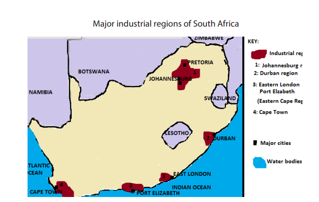
Application activity 11.4
1. Compare the factors that have led to the development of industries in
Japan with those of South Africa
2. Analyse the economic importance of industrialization in these countries:
a. USA
b. Egyptc. Russia
End unit assessment
Make a field trip in any industrialized area around your area and answer the
following questions:1. Discuss the physical and human factors influencing location of industries
in an area.
2. Describe how industrialization contributes to sustainable development.
3. Analyse the ways of improving the level of industrialization in developingcountries.
UNIT 12 TRANSPORT AND COMMUNICATION IN THE WORLD
UNIT 12: TRANSPORT AND COMMUNICATION IN
THE WORLD
KEY UNIT COMPETENCE:
By the end of this unit, I should be able to analyse the impact of transport and
communication projects on the sustainable development of different countries in
the world.
Introductory activity:
Read the passage below and answer the following questions.
In eastern province of Rwanda there is a high production of banana. Mr. Gatabazi imported a
lorry to help the people to carry their harvests to the market instead of using
their heads. Gatabazi extended his businesses and became a businessman in
the city of Kigali. He started to import his products from China. Sometimes he
goes there to purchase goods or calls his partners using his mobile phone,
then orders his goods, and pays using his BK Visa card, and finally gets his
goods without moving from Rwanda to China.
What types of transport mentioned are above?1. Explain the economic importance of the transport that Gatabazi12.1. Transport
introduced in that area.
2. Describe the types of transport that he uses to import goods from China.
3. What form of communication that he uses to get his products?4. Mention other types of communication he can use to order for his goods.
12.1.1. Meaning and types of transportLearning activity12.1
1. Observe the above photographs and identify the types of transport
shown.
2. Which type of transport is common in your area and why?
The term transport refers to the movement of passengers and goods from one
place to another. All means of transport need places where journeys start and end.These are called terminals.
Terminals for land transport are called Bus station or Train station. Those for air
transport are Airports while terminals for water transport are called ports. There are
two types of ports such as in-land ports and sea Ports. A port needs a productive
hinterland, that is an area from which the ports receives goods and passengers and
where they are delivered (areas surrounding a port).
A. Types of transport
There are three main types of transport as described below with their advantages
and disadvantages:
• Land transport
• Water transport
• Air transport
i. Land transport
Land transport is the type of transport that takes place on land. It can be
subdivided into: Human portage, Animal transport, Road transport, Railway
transport and Pipeline transport.
a. Human portage / porterage:
This is when people carry their load on their heads, on their backs or in their hands.
It is the most used transport by most people in various parts of the world. It is
predominant in developing countries because of limited capital and infrastructure
to use modern facilities and inaccessibility of an area. For example, lack of roads toreach remote areas.
Advantages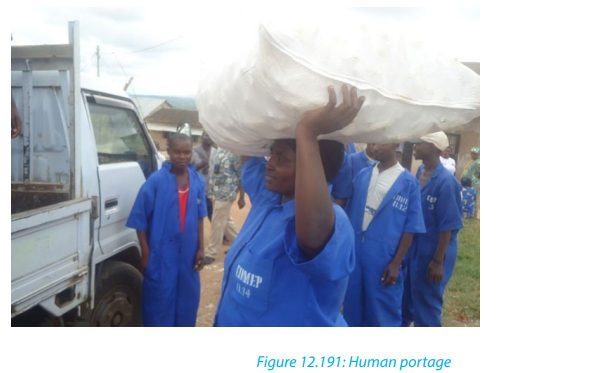
• It helps in inaccessible areas.
• It is cheap compared to other forms of transport.
Disadvantages:
• It is very slow compared to other forms of transport.
• It requires a lot of human energy and is time consuming.
b. Animal transport:
This form of transport is commonly used in areas where it is not easy to develop
other means of transport especially in arid (desert) areas. Animals used include:Camels, cows, Horses, Donkeys etc.
Advantages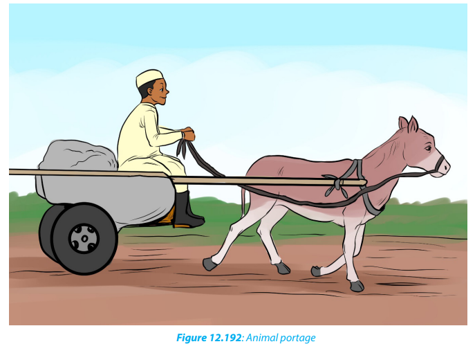
• It is used in wild areas where other means are not possible.
• It is quicker than the human portage.• It is suitable in areas where human labour is limited
Disadvantages
• It is slow compared to road transport.
• Some animals cannot move in hilly areas.
• Some animals cannot withstand certain climatic conditions.
c. Road transport:
This involves the movement of goods and passengers mainly by vehicles, bicyclesand motorcycles.
Advantages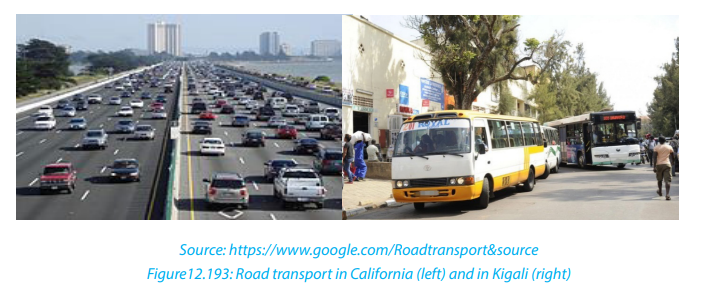
• Roads can be constructed in areas which are accessible to other forms of transport.
• Because of being flexible goods can be sold on route or can be delivered any
time.
• It is cheaper and faster for short distances.
• In some cases, it does not require large capital, except road construction.
• It is easier for people to own and purchase vehicles, bicycles and motor cycles
than airplanes, motors boats and ships.
• It provides door to door services.
Disadvantages• Heavy loaded Lorries are too slow.
• Weather conditions affect road transport especially during the rainy season.
• There are expensive to construct and maintain especially in towns.
• Roads are affected by congestion and traffic jams in heavily populated urban
areas.
• Unsuitable for heavy and bulky goods compared to water transport
• Vehicles at times run empty because of not having a scheduled timetable.
d. Railway transport
This involves the carrying of passengers and goods by train or tram along designatedroutes.

Advantages• It is cheaper for transporting bulky goods.Disadvantages
• It is less affected by weather conditions.
• It uses known routes and known timetable.
• It carries more load and a big number of people.
• It is safe since the chance of accidents or breakdowns are minimal.
• The use of railway lines does not allow trains to reach remote areas.• It is very expensive for short distances.e. Pipeline transport
• It is not suitable for carrying perishable commodities.
• It is time consuming/ slow.
• It is costly in terms of maintenance. Currently trams are being replaced by
buses in modern cities.This involves the movement of liquids and gases through a pipe from one point toanother.

Advantages:• It is cheap and easy to maintain.Disadvantages:
• It is relatively fast.
• It can be used to transport large quantities of liquids at a single time.
• It is not affected by weather conditions.
• It does not pollute the environment.
• It is free from traffic congestions.
• It is convenient in transporting highly inflammable commodities such as petroleum.• It cannot be used to transport other commodities, apart from gas and liquidf. Water transport
only.
• It may be damaged leading to heavy losses.
• It does not provide door to door services.
• It is expensive to construct.
This is the movement of goods and passengers on water by use of ships, ferries,canoes and boats. It involves both in-land and marine water ways.
Advantages of water transport.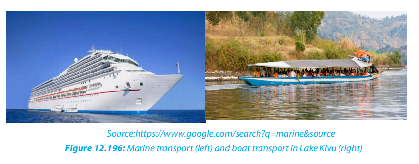
• It does not require any route construction.• It is the cheapest for bulky goods.g. Air transport
• Bulky commodities can be transported over a long distance.
• It experiences less traffic congestion compared to road transport.
• It is suitable for carrying fragile goods because there is no shaking.
• Disadvantages of water transport.
• Construction of sea port is too expensive to be afforded by most countries.
• It is used by areas with navigable water bodies i.e. limited in use by landlocked
countries.
• It can be affected by sea pirates.
• It is very slow in movement compared to air and road transport.
• Obstacles on rivers such as rapids, waterfalls, floating vegetation, sand bars,
aquatic animals, make them un navigable hence affecting movement of water
going vessels.
• Canals are affected by seasonal changes.• Storms and winds sometimes interfere the ship schedule.
This is the form of transport that uses flying objects in the air such as airplanes,drones and balloons.
Advantages of air transport
• It is the fastest and most comfortable method of transport.
• It is suitable for transporting perishable commodities.
• It is suitable for carrying urgently needed goods.
• It can go to any place with an airport.
• It is secure, not subjected to robbers.
• It is less affected by relief features.
• It does not need any route construction compared to road and railway
transport.
• Its time saving sine it follows a specific time schedule.
Disadvantages of air transport
• It causes air and noise pollution.
• It has limited storage space.
• Usually weather conditions such as fog interfere with its schedule.
• It is very expensive in terms of movement costs.
• Long time is taken in air traffic control at airfields. e.g. checking and booking
• It requires large capital in airport construction and aircraft purchase.
• It requires highly skilled man power to operate.
• It is a target for terrorist attacks.
Application activity 12.1:
1. Explain why land transport is the most used type of transport in Rwanda
compared to air and water transport.2. Describe the challenges associated with road transport.
12.1.2. Factors influencing the development of transport and
importance of transport
Learning activity 12.2
1. Rwandair is improving its business worldwide. Explain the importance of
that improvement?
2. Make research and analyze the physical and human factors that influence
the development of transport in your district.
a. Factors influencing the development of transport
The factors affecting transport are physical, political and socio- economic. They are
discussed below:
• Relief: Steep slopes make the construction of roads and railway lines expensive.
On the other hand, valleys have swamps, that contain water logged soils that
are too soft to allow heavy objects like trailers, Lorries and trains to move on
them.
• Climate: Too much rainfall results into floods and landslides, hindering
transport on the ground. On the other hand, accumulation of fog and clouds
reduce visibility hence affecting transport.
• Vegetation: Thick vegetation cover makes construction of road and rail networks
difficult because it requires uprooting big trunks of trees. Furthermore, thick
vegetation modifies climate through evapo-transpiration hence affecting air
transport.
• Capital: The construction of roads, railway lines and airports is expensive. At the
same time, a lot of money is required to buy ships, trucks as well as airplanes.
• Political instabilities: Wars lead to massive destruction of transport means and
infrastructure such as roads, wagons, airports and ports, making transport
extremely difficult.
• International restrictions based on international boundaries: These affect
transport in that they restrict amount of freight. The same applies to road
transport.
• Economic factor: The structure and nature of transport costs are examined,
together with service quality and methods of pricing and charging.
• Government policy:These include political motives for transport facilities; g
overnment involvement in capital, monopoly, competition, safety, working
conditions and coordination between modes, transport as an employer and socialconsequences of transport developments.
A. Importance of transport to the development of countries
Efficient transport is an important factor for economic development on both global
and national scales. It can be a boost or a barrier to economic growth. Transports can
contribute to economic development in the following ways:
• Transport promotes trade and industrialization through the transportation of
necessary raw materials to factory for production of goods and finished goods
to consumers
• Transport systems offer employment opportunities to many people.
• Transport promotes urban development as many urban centers have
developed where transport network converges.
• Promotion of international relations since transport brings leaders together
face-to-face talks.
• Promotion of tourist industry, tourists move by use of means of transport.
• Stimulation of the development of other sectors such as, agriculture, fishing
and mining.
• Transport increases revenue through taxes to the government and income tolocal transporters.
Application activity 12.2:
Visit the nearest taxi park and note what you observe in terms of economicimpact of the transport.
12.1.3. Problems/challenges affecting transport and strategies of
improving transport.
Learning activity 12.3.
Analyse the photograph below taken in Nyabugogo andexplain the phenomena that occurred in relation to the problems affecting transport.
a. Problems/challenges affecting transport
There are major problems affecting transport activities as mentioned below:• Inadequate capital: Transport requires enough capital investment. That is why
it becomes difficult for developing countries that have weak economies to
construct and maintain transport facilities such as roads, airports, ports, and
railway lines.
• Natural barriers: Hostile environment such as deserts, forests, rugged and
mountainous terrain hinders the establishment of transport facilities.
• Political instability: Some countries have undergone periods of political
instability. With long periods of fighting in these countries, transport facilities
were targeted for destruction while new lines were not established.
• Climate like heavy rainfall and floods make roads muddy and slippery. BadApplication activity 12.3:• Mass wasting like landslides and mudflows affect roads in mountain areas andclimate disturb air transport also.
make roads impassable for some times.
• Low technology causes over dependence on imported expertise and
technology which are expensive. This is associated with lack of skilled man
power to construct infrastructure.
• Presence of water falls and rapids along river courses and their tributaries
make water transport difficult.
b. Ways of improving transport
• Ensuring political stability and avoid wars that destroy transport facilities.
• Containerization of the ports and harbors for effective handling of goods and
reduce delays.
• Government policies. Governments have to develop and implement
international transport projects like building international highways or railways
as the project understudy between Rwanda and Tanzania. Such policies boost
transport development.
• Bridges are constructed across rivers to connect different areas across rivers
and streams.
• Draining swamps for road construction.
• Improve engineering technology and use of national resources and materials
to construct transport infrastructures. There is also need to train skilled
manpower.
• To develop air transport for both domestic and international connections in big
countries like it is the case in USA, in areas with large impenetrable rainforests
like Equatorial forests in DRC or Amazonian forest in South America and largewater bodies (oceans).
1. Using examples, explain the challenges affecting transport in Rwanda.12.1.4. Case studies
2. Suggest different ways Rwanda as a landlocked country can use to
improve its international transport.Hui con ta estrari bunimum fautomperfinte popore tus, ses, culegerum se firtius inatui cum nihilic
Learning activity 12.4:
Make research, and find where the following are located on the world map:
Tanzam railway, Trans African Highway, Trans- Siberian railway, Rotterdam
Europort and St. Lawrence sea way.
a. Tanzam railway / Tazara railway
Tanzam railway also called Uhuru railway runs from Kapiri-Mposhi in Zambia,northwards to Dar es Salaam on the Indian Ocean in Tanzania. It was opened in 1975.
i. Major aims of Tanzam Railway • To promote Tanzanian and Zambian exports and imports.ii. Benefits of the Tanzam Railway
• To solve Zambia’s problem of being landlocked,
• To create accessibility to the sea for export of copper.
• To open up the southern highlands of Tanzania which were productive butremote.
• Tanzam Railway provides landlocked Zambia with reliable access to the sea
and therefore made the flow of trade easier.
• It promotes economic development in remote parts of Tanzania which were
not accessible.
• It leads to political and economic development of Tanzania and Zambia.
• Industrial growth has been achieved since both raw materials and finished
goods can be easily transported by using railway. Tanzam railway encouraged
the development of mineral exploitation in Tanzania and Zambia e.g. coal and
Zambian copper.
• It provides employment opportunities for the local people like drivers,
technicians, casual laborers and earns income to improve their standard of
living.
• It has contributed to the economic growth of the port of Dar-es-Salaam while
increasing government revenue.
• It contributes to the development of tourism especially to Tanzanian through
port charges.
• It influences the development of other transport systems like feeder roads.
• Railway reduces transport costs incurred by Zambia compared to using the
ports of other countries for its trade such as Lobito in Angola.
iii. Shortcomings of Tanzam Railway
• The serious delays on the route because of the long distance covered.
• High cost of maintaining the railway lines due to frequent breakdown. Railway
need to be regularly rehabilitated and upgraded.
• It is affected by the weather conditions (heavy rain). Kilombero valley section
is always exposed to flooding.
• Zambia faces the problems of high taxes in the payment of port charges at
Dar-Es-Salaam.
• There is poor management of railway lines due to corruption and
embezzlement. Private sectors can better manage the railway.
• There is a use of old line structure with shortage and inappropriate locomo-
tives and wagons. There is a need to develop systematic programs to replaceold locomotives and wagons as well as communication systems.
b. Trans- African Highway (T.A.H)
This is a highway that starts from Cape Town to Cairo linking the Northern and
Southern regions of Africa. It passes through Bulawayo, Harare, Lusaka, Dar-es
Salaam, Nairobi, Addis Ababa and Khartoum to reach Cairo. It has deviations to serve
other regions adjoining the highway. It also runs from Mombasa through Uganda,
DRC and Cameroon to Lagos in Nigeria. The main purpose to build Trans-AfricanHighway was to promote trade between all corners of Africa.
i. Advantages of the Trans-African Highway:
The Trans-African Highway has too much benefited the African States in / by which
it passes in the following ways:• It has enhanced cooperation among the countries through which it passes.c. Trans- Siberian railway in Russia
• The highway spearheaded the formation of economic and political unions
such as East African Community (EAC) and Economic Community of West African States (ECOWAS).
• It has increased trade prospects between member States and has also
stimulated trade on the continent by facilitating easy movement of people
and goods.
• It has enabled the development of the remote parts of African countries.
• It encourages tourism in those countries where it passes and the distribution
of human settlement patterns (linear and nucleated types).
• It is important in the transportation of agricultural raw materials.
ii. Problems facing Trans-African Highway
The following are the major problems facing trans-African highway:
• Political instability or wars) in some African countries in which the high way
pass has limited transportation of goods along this highway, this has affected
its effective use.
• Frequent civil conflict affects its performance in various parts of the continents
where the high way is passing.
• Some countries charge high tariffs at the border posts which is increasing the
cost of transport.
• The volume of trade along the highway has further reduced due to delays
caused by numerous border bureaucracies of screening and vetting of goods
and passengers across borders.
• Insecurity and loss of goods on transit caused by banditry and smuggling
along these highways have made the highways unsafe. This has further
reduced their usage.
The Trans-Siberian Railway is a network of railways connecting European Russia from
Moscow with the Russian Far East and the East Sea / Sea of Japan. It is the longest
railway in the world with a line length of 9,259 km. There are branch lines to Chinathrough Mongolia and Manchuria. It was started in 1891 and completed in 1916..
i. The importance of the Trans-Siberian Railway: • The Trans-Siberian Railway gave a positive boost to Siberian agricultural crops.ii. Challenges of Trans- Siberian railway:
Wheat, rice, potatoes and sugar beet are grown. This facilitates substantial
exports to central Russia and Europe.
• It influenced the territories it connected directly, as well as those connected to
it by river transport.
• It attracts many foreign tourists in Russia, Siberia through creating accessibility
to tourist attractions like Ural Mountains, Lake Baikal, and Moscow metro
tunnel.
• The Trans-Siberian Railway encourages rural settlement in the inhabited areas
of Siberia
• Development of towns. Trans-Siberian railway runs through important towns
like Omsk, Novosibirsk, Irkutsk and Ulan-Ude, etc. These towns developed
accommodation, commerce, health and education services.
• Improvement of industrial development through transportation of raw
materials such as copper, phosphates, coal, iron, etc.
• Development of trade between the Eastern Europe and Asian countries like
Japan, China and Siberian.• Political and economic unity between the East and West Russia was achieved.
• Its construction led to clearance of forests as well as destruction of Urald. Rotterdam (Europort in the Netherlands)
Mountains
• It led to over exploitation of resources such as iron and steel from Karaganda
field and oil from the west Siberian oil fields
• Loss of lives through accidents like derailing of the trains and sometimes
collision.
• It led to urbanization in former natural environment areas with its relatedproblems such as congestions, slums development, and pollution.
Rotterdam is a port located at the mouths of rivers Rhine and the Meuse on the
North Sea. The name is derived from a stream known as Rotte. Today, the major
development is concentrated on Euro Port on the seaward end of new waterway and
not at Rotterdam. It is one the busiest port in the world. Rotterdam port serves a largerich hinterland of Belgium, France, Netherlands, Luxembourg and Switzerland.
i. The factors which influenced the growth of Rotterdam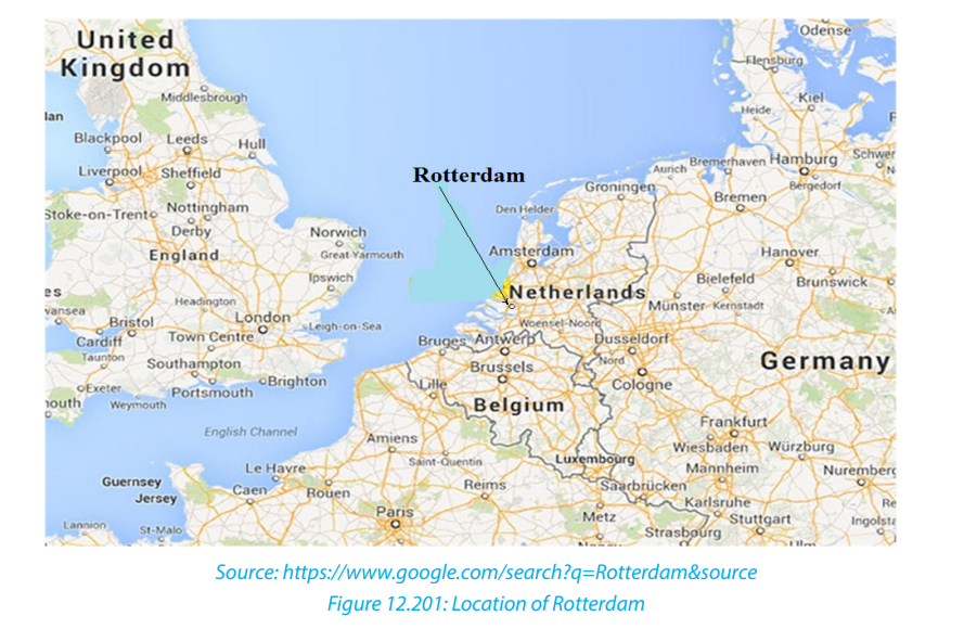
Inland water transport:
Rotterdam has a well-developed in-land water linkage to the interior of Western
Europe.
These navigable rivers link the port to its hinterland: Elbe, Rhone and Danube.
• Strategic location:
The port of Rotterdam is centrally located where sea routes converge such as the
sea route to the North America, Africa and various parts of Europe and even Asia.
It is an important waterway for Ruhr industrial region.
• Suitable climate:
Rotterdam experiences a cool temperate climate. Like the other ports in the world,
Rotterdam enjoys conductive weather conditions free from mist throughout the
year.
• Establishment of industries:
Rotterdam is located in a region of heavy industrialization. The major industries
are oil refineries, food processing, ship building, petrochemicals, iron and steel
industries. The importation and exportation of both raw materials and finished
products through the port have led to its expansion making it the busiest port
in the world.
• Large and rich hinterland:
Rotterdam has a wide and rich hinterland which traverses the neighboring rich
countries such as Belgium, Switzerland, Luxembourg, Germany, France, and
Austria. The hinterland is rich in grains, mineral ores, iron and steel products.
The port therefore handles a large volume of import and export goods which
influenced its growth.
• There is a high level of technology:
The high level of technology is used in the construction of canals and its
maintenance, pipelines, railway lines that link the port to its hinterland.
• The availability of sufficient capital:
This has facilitated the expansion of port activities over the years. Big projects
for the development of the port were implemented such as the expansion of
industrial storage facilities, construction of pipelines, canals, railways and high
ways, etc.
• Proximity of Rotterdam to the North Sea:
North Sea is one of the busiest international routes in the world. This proximity
increases the amount of Cargo handled by the port, thereby fastening its growth
and development.
• Low tidal range:
The difference between the low tide and high tide at Rotterdam is very small. This
allows large ships to use this port. Many ships are able to load and off-load their
Cargo because of this unique characteristic.
• Favorable government policies:
The government of Netherland supported the establishment, growth and
development of Rotterdam port. It provided the capital for establishment of port
structures, established the authority which was given responsibilities of running
the port activities.
• Skilled man power:
Being in an area that is developed with modern universities the port benefited
from a large supply of skilled man power required in the port establishment.
ii. Problems facing Rotterdam Euro port:
• Problem of congestion because of many water going vessels.
• Pollution of the environment as a result of industrialization, urbanization,
vehicles which releases fumes to the atmosphere.
• Siltation of the river Rhine is a problem that faces the port.
• There is limited land for further expansion of the port.
• Overcrowding at the port due to many people.
• Big Population at the port made housing very expensive.
• High levels of unemployment because of high demand for jobs and this
sometimes results into the problems of crimes
• The problem of flooding because Rotterdam is located on the north part of
Netherlands which is a low-lying area.
• The problem of poor visibility resulting from fog and smoke at the port. This
leads to accidents and sometimes delays delivery of cargos.
• The problem of accidents by ships which often leads to the loss of Cargo and
sometimes lives.
• There is also problem of prostitution brought about by attraction from a large
population.
iii. Steps being taken to solve the problem:
• The construction of storm surge barrier automatically operated the control
storm surges and minimizes flooding at the port. Dykes have also been
constructed for this purpose.
• There is an increased use of radar system to avoid collision of vessels during
foggy weather conditions.
• The port authority occasionally dredges the river Rhine and Maas thereby
ensuring that they are free from silt and can be safe to ships.
• The industrial wastes are treated before they are released to the environment.
This minimizes the case of pollution. The noise is also carefully monitored and
regulated to avoid noise pollution.
• There is containerization to ensure safety of cargo, fast handling and dispatch
of cargo.
• The port authority has also reclaimed land from the North Sea marshlands and
the rivers to create more space for the port.
• There is a strict control of crimes through deployment of security personnel to
monitor and discourage criminal acts at the port.
e. St. Lawrence sea way (USA-CANADA)
St. Lawrence seaway stretches from Port Duluth on Lake Superior to port St.
Lawrence on the Atlantic Ocean. It covers a distance of 3,800 Km. It is the longest
inland waterway in the world with the largest volume of traffic. It serves Canada
and the USA. It allows passage of ocean going vessels. Before the sea way was
constructed, large ships could only sail on the great lakes up to St. Lawrence town as
far as Montreal. The construction of St. Lawrence seaway was a joint project venture
between the governments of Canada and USA. The construction works began in
1954 and ended in 1959.
The main aim was to create deep water for navigation between Lake Ontario and
Montreal. This would allow ocean going vessels to sail from the mouth of the St.
Lawrence River onto the western shores of Lake Superior.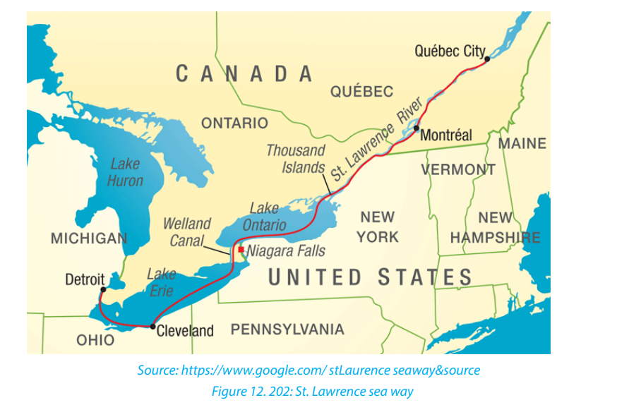
i. Economic benefits of St. Lawrence seaway for the USA and Canada• Cheap transport: The seaway has offered a cheap means of transport from
the interior of North America to the Atlantic Ocean. The ocean liner finds it
direct, quick and short to access the interior as opposed to the previous route
through New York. This has enhanced the movement of people and goods.
• Creation of employment: Through transportation of raw material and finished
products along the seaway, there has been an increased volume of traffic. This
has created job opportunities.
• Generation of hydroelectric power: The construction of dams along the seaway
like Saunders and Beauharnous on Niagara Falls has led to the generation
of abundant power. The power is cheap and reliable. It is used for both domestic and industrial use.
• Growth of Towns: St. Lawrence Sea Way has encouraged urbanisation along its
shores. This is because the ports along it have attracted settlement. Examples
of such towns are Quebec, Duluth and Hamilton.
• Increased volume of trade: St Lawrence Seaway has led to the increase of the
volume of trade between the USA, Canada and the rest of the world. This has
been due to the ease of transporting of goods such as iron ore, copper, wheatii. Problems of St Lawrence sea wayDevelopment of tourism: The seaway with the spectacular Niagara Falls is aand manufactured goods.
great tourist attraction. This has earned foreign exchange to the two countries.
• Development of industries: The seaway has contributed to the development
of industries in the USA and Canada. The power generated from the dams is
directly used in the industries. Likewise, water from the dams is used in cooling
industrial plants.• Congestion, unemployment, high crime rate due to the growth of urban centers.
• High cost of maintaining the seaway like dredging to solve the problem of
silting.
• Decline in fishing activities due to destruction of wetlands and fish habitant as
a result of dredging and blasting as well as pollution of water.
• Many rocks which are used to adjust the level of water to improve navigation.
These result into delays in movement.
• Increase of pollution due to oil and chemical spills as a result ofenormous increase of cargo size as well as industrialization.Application activity 12.4:1. Explain the problems that were encountered during the construction of12.2. Communication
Tran- siberian and Tanzam Railways.
2. Analyse the factors for the growth of Rotterdam port in Europe
3. Briefly describe how Trans African Highway and St Lawrence seaway have
contributed to development in their respective countries and continents.
Communication is a medium of sending and receiving information through various
means. It is a very vital aspect of the society. Without communication, spatial
interaction between people and communities would not be possible. People
communicate to get needed things such as information, money, advice or just
emotional support.
12.2.1. Meaning and types of communication
Learning activity 12. 5:
Observe the following images and explain how these devices are used forcommunication purposes
a. Types or forms of communication
There are different links, instruments and devices used in the transmission of
information from one point to another. Early modes of communication included
sending runners with verbal messages, fire and smoke signals, and later drums and
horn blowing. The invention of writing led to improved communication as letters
could be delivered to various destinations.
Those methods of communication were found to be slow and inaccurate in some
instances and limited in terms of the distances they could cover. The rise in electrical
technology led to a new concept in communication known as telecommunication,
which is communication over long distances.
The current modes of communication include telegraph, telephone, fax, e-mail,
courier, handwritten, television, radio, social networking.
The following are the main types of telecommunication:
i. Telegraph: Telegraph enabled messages to be transmitted by cables as
a series of electrical impulses. The signals were in the form of the Morse
code, which could be easily interpreted. Most places were thus linked by
telegraphic cables. Undersea cables were also laid below the oceans.
ii. Telephones: This is where cables connected to a local exchange are
used to transmit voice messages over long distances. The sound waves
are changed into an electric current which is then transmitted to the
receiver phone, where it is then interpreted by being re-transformed into
sound waves that can be interpreted by human ear. Due to technological
improvement, the cable fixed phones are being replaced by smart mobilephones which perform various communication tasks.
iii. Radio: is a way to send electromagnetic signals over a long distance, to
deliver information from one place to another. It also usually stands as a
machine which sends out and receives messages using air waves to a largemass of people
iv. Television: is a piece of electrical equipment which shows pictures
through the air or along cables
v. Internet: Internet means “interconnected networks”. It is a large system
of connected computers around the world that allows people to share
information and communicate with each other. It is a system that links
devices worldwide.
Application activity 12.5:
Explain the most forms of communication used in Rwanda and why.
12.2.2. Importance of communication, problems affecting
communication and their solutions
Learning activity 12.6
Many business people in the city of Kigali no longer need to travel to
purchase their goods in the foreign countries. They use different types of
communication to order for the goods and get them in few days in Kigali.
1. What do you think can be the consequences of such form of
communication?
2. Explain the importance of communication.
a. Importance of communication
The following are the main positive effects of communication:• Communication system facilitates economic development by sendingd. Interrelationship between Transportation, Communication and Economic
information to various locations of the world. Communication system
connects industries and business communities to take right decisions at the
right time by providing them with information and news related with business
and financial matter. For example, it is possible to know about the price of the
commodity prevailing at any part of the world quickly. This promotes domestic
and international trade.
• Communication is the basis of organisational functioning: good communication
is an essential tool in achieving productivity and maintaining strong
working relationships at all levels of an organisation. It is only when necessary
communications are made to subordinates and operators; about their jobs
that action is possible due to communication.
• Communication sector has led to the creation of employment opportunities
to a variety of categories of people such as journalists, media managers and
users
• Investors in the sector of communication such as radio, television and social
media (e.g. Facebook, WhatsApp, YouTube, etc. get more revenue and many of
them belong now in the world’s richest class.
• Communication facilitates easy dissemination of information to remote areas.
• Communication helps in building good public relations: good public relations
comprise relations of the enterprise with outside agencies, particularly
consumers and the public at large.
b. Problems affecting communication
The following are the problems affecting communication:
• Inadequate capital: Many developing countries experience a problem of weak
economies and few industries. They thus have insufficient funds needed to
construct and maintain communication facilities.
• High taxes:there are high taxes attached to the importation of communication
equipment as well as high operation charges.
• Inadequate technical know-how: This has hindered the growth of
telecommunication since most countries have to rely on expatriates whose
payments are very high.
• Natural barriers: desert, forest, rugged and mountainous terrains have hindered
the establishment of communication facilities like telephone boosters.
• Competition: there is competition between the local companies involved in
the sector and free online communication systems.
• Lack of skills: there is general lack of knowledge and skills to use
telecommunication devices such as computers, radios, newspaper, etc.
c. Possible solutions to the problems affecting communication
Drawing from the problems facing communication discussed above, it is evident
that most of them can be overcome by way of reversing them.
• Political stability: there should be dialogue between countries and the use of
peace talks should be emphasized.
• Investing in communication and where capital is not available, looking for
ways of getting it through loans or aid.
• Countries should invest more on training their people so as to equip them
with knowledge to hand the ever-changing technology. It is cheaper to train
home-grown personnel than to hire expatriates.
• To increase the knowledge in technology: Use the recent technology
radio, telephones, television, and internet to improve the standards of
communication.
• Communication is the link between knowledge and information. Therefore,
there is need to provide knowledge of the people to be able to communicateproperly.
Development
1. Both transportation and communication play some major roles in the
economic uplift of a country as they promote internal and external trade.
2. Transportation and communication systems help to promote the use of
natural resources, mobility of skilled labour-force, diversification of markets,
provision of fuel, increase in agricultural and industrial production.
3. Efficient transport and communication systems help to establish
relationships among people in different parts of the world, these have
also strengthened the feeling of unity among people in different cultural
backgrounds.
4. Transport and communication systems help to create job opportunity
for people living in the rural areas by connecting labourers and creating
employment for them in the industries, however these have also solved the
needs of industries and reduce unemployment.
5. The development of transport system also leads to development of
industries because transport system utilizes the product of industries and
both complement each other in different ways.
6. Efficient means of transport and communication have indeed shortened
time, distance, and cost that would have been used to move and to deliver
goods and information from one person to another.
7. Transportation and communication help to increase the size of the market
of your products by helping you to transport your products across different
countries which will help you to increase your sales in those countries that
is, by penetrating new markets.
8. Through the effective transport and communication systems one will know
how to strategies in terms of war and also curtail crisis from taking place at
any point in time.
9. Government can swiftly evacuate or inform her people against any
occurrence of natural disaster, outbreak of diseases and other social
problems through the means of transportation and communication system.
10. The production and distribution units (farms, factories, central places) that
are under primitive or high-cost transport conditions, had to be scattered
to serve distant markets, have tended to become spatially concentrated
in areas of greatest advantage. Market areas therefore have become even
more extensive as transportation has improved. Similarly, supply areas
have expanded. For instance, agricultural production has become more
profitable and so wider areas of production are opened up from the central
markets.
11. Transportation revolution has therefore significantly improved accessibility
of places and therefore bringing more developments and growth. This is
because transportation is the main vein through which developmentalfacilities and services are channelled. The level of transport development of
many areas therefore positively correlated to the level of economic growth
and development.
12. Transportation plays a major role in the economy, which increases theproduction efficiency and links to the logistic systems.
Application activity 12.6
1. Explain factors hindering effective communication in your area.
2. What is being done by Rwandan government to improve communication?
End unit assessment
1. Examine the relationship between communication and transport.
2. Explain the role of the government in ensuring effective
communication in Rwanda.
3. Referring to MTN, TIGO and AIRTEL explain the importance of
telecommunication companies in the development of the country.
4. Explain the factors that have contributed to the development of
transport in developed countries than developing countries.
5. Analyze the level of transport and the improvement of technology in
communication in Rwanda and describe how this process can support thesustainable development of the country
UNIT 13 TRADE AND COMMERCE IN THE WORLD
UNIT 13: TRADE AND COMMERCE IN THE WORLD
Key Unit Competency:
By the end of this unit, I should be able to evaluate the impact of trade and commerce
on the sustainable development of different countries in the world.
Introductory activity:
For different reasons, many countries come together and create regional
bloc such as European Union or East African Community. Conduct your own
research and answer the following questions.1. Identify different regional integrations operating with Rwanda.13.1. Definition, types of trade and factors influencing international
2. What advantages does a country benefit from being a member of atrading bloc?
trade.
Learning activity13.1
Madame Kayitesi buys goods in large quantities from Inyange Industry. She
owns one of the biggest shops in her village. Her products are bought by the
local people and she takes some to the nearest markets in her district. Some
of the products made by Inyange industry are exported overseas.
1. Identify the major imports of Rwanda
2. Mention the types of trade indicated in the passage.
3. Explain the factors influencing trade between Inyange industry and
overseas countries.
13.1.1. Definition of key terms
Trade: Is the activity of buying and selling or exchange of goods and services within
a country or between countries. It also occurs between two individuals through the
exchange. Trade is part of commerce.
Commerce: Is the activity of buying and selling of goods and services, especially
on a large scale or quantity. It goes along with the activities such as insurance,
transportation, warehousing, advertising that completes that exchange. Commerce
stands as a wide system that includes legal, economic, political, social, cultural and
technological systems that are in operation in any country or internationally.
Trade is simply the exchange of commodities, and this can take place at many
levels. The earliest form of trade was probably “barter trade” in which one type of
commodity was exchanged for another of equal value.
The present trade is based on the exchange of goods and services for money. It
includes the following forms:
a. Internal trade: This is the exchange of commodities within a country. It
is also known as domestic trade. Traders normally need to exchange what
they have with what they don’t have. It includes:
• Whole sale
This occurs when traders buy goods in bulky from both the manufacturers and
importers. They then break them into smaller units and sell them to kiosk owners,
hawkers, shopkeepers and supermarket;
• Retail trade
This is where traders buy goods from the wholesalers and sell them in detail to
the individual customers.
b. International trade: This type of trade occurs between different nations of
the world, on a global scale. Its rationale lies in the fact that no country can
produce everything that it needs. It therefore has to acquire what it cannot
produce from others through trade. It involves:
• Bilateral trade: it is a trade between two countries.
• Multilateral trade: it is a trade between many countries, through the exchanging
imports where goods and services bought and brought into the country, and
exports where goods and services are transferred to another country for sale.
13.1.2. Factors influencing international trade
The type and volume of trade that takes place at any level in any place is influenced
by a number of factors. The most important factors are:
• Capital: This is the greatest single factor influencing trade. Money is the engine
that runs trade. Traders require capital to establish their businesses, purchase
their wares and transport the commodities. Where capital is inadequate the
volume of trade will also be low.
• Demand and supply: For trade to take place there must be sufficient demand
and good chain of supply of the items.
• Transport and communication: Trade depends highly on efficient means of
transport and communication. For example, manufactured goods and other
trade items need to be transported to the market. Traders also need to move
from one place to another to effect various trade related transactions. Traders
have to further communicate while placing orders and while establishing the
market situation.
• Trade barriers: This includes the quota system for international trade, where
a country may impose limits on imports and exports. They also include tariffs
and duties levied on goods, which if increased may discourage the importation
and exportation of some goods.
• Government policy: This is where the government influences trade in certain
commodities through taxation. For example, the government levies heavy
taxes on certain goods such as cigarettes and alcohol.
• Creation of trading blocs: The creation of regional common trading markets
enhances trade due to increased cooperation between the member countries.
Trade is further promoted because the market is usually expanded.
• Political climate of a country: Political problems such as wars affect both
internal and external trade because wars discourage foreign investors and
at times destroy industries; whereas good diplomatic relationship between
countries encourages foreign investments.
• Population factors: population size, structure, distribution and the diversity
between peoples affect the types of goods traded and the volume of
international trade.
• Differences in natural resources: Natural resources are not evenly distributed in
the world. This is mainly due to differences in climate, sols, relief and geologicalfactors.
Application Activity 13.1:
Discuss how the following factors influence international trade in Rwanda:
1. Regional integration
2. Government policy3. Population
13.2. Causes of low levels of international trade in Developing Countries
and importance of international trade in the development
Learning activity 13.2
Most of the industrial products used in developing countries are imported
from Europe, USA, ASIA etc. African countries also export agricultural
products to the rest of the world but the gap between imports and exports
in less developed countries still remains big.
1. Identify the products exported by European countries in Africa.
2. Outline the major exports of Rwanda to the developed countries.
3. Explain the causes of this inequality between exports and imports.
13.2.1. Causes of low levels of international trade in Developing Countries
The following are the major factors causing the low levels of international trade in
Developing Countries:• Access to foreign markets: The foreign markets are dominated by the goods
and services from developed countries because they have better quality and
produce more quantity of goods.
• Inadequate and insufficient domestic supply on the international market: this
causes the increase in prices and this affects the final consumers.
• Most of the developing countries export unprocessed products due to
shortage of industries or low level of technology. These unprocessed products
also called raw materials are undervalued on international markets.
• Most of the developing countries and other low-income countries export bulk
products such as horticulture products, fruits, vegetables and animal products.
These perishable products account the risks to be damaged in transport
process.
• Developing countries have also been concerned with the growing importance
of free trade areas and customs unions in recent years, which now cover
virtually all their major export markets, including Europe and North America
since most of the major regional trading arrangements do not include them,
• Implications of anti-competitive practices by private enterprises in restricting
the market access of developing countries to industrialized countries.
• Quota policy on the international market is negotiated only among the
developed countries and developing countries must follow their resolutions.
• Capital inflows: the growing constraints on foreign aid and the difficulties in
attracting increased foreign private financing and investment are affecting thegrowth prospects of countries lagging behind in global integration.
• Financial liberalization in developing countries has mainly comprised the13.2.2. Importance of international trade in development
reduction or removal of allocative controls over interest rates and lending, the
introduction of market-based techniques of monetary control and the easingof entry restrictions on private capital
International trade helps in development as follows:• Foreign trade and economic development: Foreign trade plays a very important
role in the economic development of any country. Therefore, economic
development of a country depends in part on foreign trade.
• Foreign exchange earnings: Foreign trade provides foreign exchange which
can be used to reduce poverty. The foreign earnings are obtained through
exportation of products especially agricultural products by developing
countries.
• Market expansion: The demand factor plays very important role in increasing
the production of any country. The foreign trade contributes to expand the
market and encourages producers.
• Foreign investment: Besides the local investment, foreign trade encourages
investors to invest in those countries where there is a shortage of investment.
• Increase in national income: Foreign trade increases the scale of production
and national income of a country. To meet the foreign demand, we increase
the production on large scale so Gross National Product (GNP) also increases.
• Price stability: Foreign trade helps to bring stability in price level. All goods
which are not sufficient, have high prices. Those goods are imported and
goods which are surplus can be exported. This stops fluctuation in prices.
• Specialization: There is a difference in the quality and quantity of various factors
of production in different countries. Each country adopts the specialization in
the production of specific commodities, in which it has comparative advantage.
So all trading countries enjoy profit through international trade.
• To improve quality of local products: Foreign trade helps to improve quality of
local products and extends market through changes in demand and supply as
foreign trade can create competition with the rest of the world. The country
competes with the foreign producers in foreign trade so it improves the quality
and reduces the cost of production.
• Import of capital goods and technology: The inflow of capital goods and
technology in the less developed countries has increased the rate of economic
development, and this is due to foreign trade. Foreign trade is also responsible
for spreading of knowledge and learning from developed countries to underdeveloped countries.
• Better understanding: Foreign trade provides an opportunity to the people ofApplication activity13.2:
different countries to meet, discuss, and exchange views and ideas related to
their social, economic and political problems.1. Assess the role of international trade in the economic development of13.3. Major financial centers and trading blocs of the world
Rwanda
2. Suggest ways of reducing the gap between low exports and highimports in developing countries.
Learning activity 13.31. Make research and explain the objectives of International Monetary Fund13.3.1. Major financial centers
(IMF).
2. Using specific examples, explain how the trading blocs improve theeconomic development of member countries.
A financial centre is a location that is home to a cluster of nationally or internationallya. The main global financial centres
significant financial services providers such as banks, investment managers, or
stock exchanges. A prominent financial centre can be described as an International
Financial Centre (IFC) or a global financial centre and is often also a global city.
Today, the two largest financial centres of the world in terms of volumes of capital
circulating are London and New York. In 2017, the top ten world financial centre
were London, New York City, Hong Kong, Singapore, Tokyo, Shanghai, Toronto,
Sydney, Zürich and Beijing.
The power of a financial centre depends on its history, role and significance in
serving national, regional and international financial activity. There are three prime
factors for success as a financial centre: a pool of money to lend or invest; a decent
legal framework; and high-quality human resources. The big financial centres alsohost the world biggest financial institutions like IMF, World Bank, etc.
• Amsterdam. Amsterdam is well known for the size of its pension fund market. It
is also a centre for banking and trading activities. Amsterdam was a prominent
financial centre in Europe in the 17th and 18th centuries and several of the
innovations developed there were transported to London.
• Chicago. The Illinois city has the «world’s largest [exchange-traded] derivatives
market» Dubai. The second largest emirate in the United Arab Emirates is a
growing centre for finance in the Middle East, including for Islamic finance.
• Dublin. Dublin, in Ireland, is well known because of its International Financial
Services Centre, “IFSC”). It is a specialized financial services centre with a focus
on fund administration and fund domiciling. It also conducts activities such as
securitization and aircraft leasing.
• Frankfurt. Frankfurt attracts many foreign banks which maintain offices in the
city.
• Hong Kong. As a financial centre, Hong Kong has strong links with London and
New York City. It developed its financial services industry. Most of the world’s
100 largest banks have a presence in the city. Hong Kong is a leading location
for initial public offerings, competing with New York City.
• London. London has been a leading international financial centre since the
19th century, acting as a centre of lending and investment around the world.
London continues to maintain a leading position as a financial centre in the
21st century, and maintains the largest trade surplus in financial services
around the world. London is the largest centre for derivatives markets,
foreign exchange markets, money markets, issuance of international debt
securities, international insurance, trading in gold, silver and base metals and
international bank lending. London benefits from its position between the Asia
and U.S. time zones, and has benefited from its location within the European
Union.
• Luxembourg. Luxembourg is a specialized financial services centre that is the
largest location for investment fund domiciliation in Europe, and second in
the world after the United States. Three of the largest Chinese banks have their
European hub in Luxembourg (ICBC, Bank of China, China Construction Bank).
• Madrid. Madrid is the headquarters to the Spanish company Bolsas y Mercados
Españoles, which owns the four stock exchanges in Spain, the largest being
the Bolsa de Madrid. As a financial centre, Madrid has extensive links with
Latin America and acts as a gateway for many Latin American financial firms to
access the EU banking and financial markets
• Milan. The city is Italy’s main centre of banking and finance.
• New York City. Since the middle of the 20th century, New York City, represented
by Wall Street, has been described as a leading financial centre. New York
City remains the largest centre for trading in public equity and debt capital
markets, driven in part by the size and financial development of the U.S.
economy. The NYSE and NASDAQ are the two largest stock exchanges in the
world. Several investment banks and investment managers and the three
major global credit rating agencies which are Standard and Poor’s, Moody’s
Investor Service, and Fitch Ratings, have their headquarters in New York City.
• Paris. It is home to the Banque de France and the European Securities and
Markets Authority. Paris has been a major financial centre since the 19th
century. The European Banking Authority is also moving to Paris in March 2019.
• Seoul. South Korea’s capital has developed significantly as a financial centre
since the late-2000s recession. Seoul has continued to build office space with
the completion of the International Financial Center Seoul in 2013. It ranked
7th in the 2015 Global Financial Centres Index, recording the highest growth
in rating among the top ten cities.
• Shanghai. This is one of Chinese and world financial centre. It competes with
New York and London. China is generating tremendous new capital and stateowned
companies in places like Shanghai.
• Singapore. With its strong links with London,[82] Singapore has developed into
the Asia region’s largest centre for foreign exchange and commodity trading,
as well as a growing wealth management hub. It is one of the main centres for
fixed income trading in Asia.
• Sydney. Australia’s most populous city is a financial and business services hub
not only for Australia but for the Asia-Pacific region. Sydney is home to two
of Australia’s four largest banks, the Commonwealth Bank of Australia and
Westpac Banking Corporation and to the Australian Securities Exchange.
• Tokyo. Tokyo emerged as a major financial centre in the 1980s as the Japanese
economy became one of the largest in the world. As a financial centre, Tokyo
has good links with New York City and London.
• Toronto. The city is a leading market for Canada’s largest financial institutions
and large insurance companies.
• Zurich. Zurich is a significant center for banking, asset management including
provision of alternative investment products, and insurance. Switzerland is not
a member of the European Union, then Zurich is not directly subject to EU
regulation.
• Other emerging financial centers are cities such as Mumbai, São Paulo, Mexico
City and Johannesburg, etc.
b. Examples of the financial institutions that make a city a powerful financial
center
The International Monetary Fund
The International Monetary Fund (IMF) was created in1945 and has Washington D.C.
as the Headquarter. It began with 45 members.
The aims of IMF are to promote international economic cooperation and international
trade, strives to help stabilize exchange rates among member countries. IMF takes
a lead in advising member countries and ultimately helps to avoid financial crises.
This includes developing standards that member countries follow, such as providing
adequate foreign exchange reserves in good times to help provide for increased
spending during recessions. The IMF also provides loans to help its members tackle
balance of payments problems, stabilize their economies and restore sustainable
economic growth.
The World Bank
The World Bank or the International Bank for Reconstruction and Development
(IBRD) was founded in 1944. Its headquarter is in Washington D.C.
It was set up with the aim of reconstructing the war-affected economies of Europe
(during the Second World War) and assisting in the development of the less
developed countries of the world.
Today, the World Bank is more concerned with the development of member
countries especially the developing ones. It gives loans for the purchase of capital
goods necessary for development. In so doing, the World Bank concentrates on
loans for projects that are clearly profitable. The World Bank’s current focus is onachievement of the Millennium Development Goals (MDGs)
13.3.2. Trading blocs and regional integration
A trade bloc is a type of inter-governmental agreement, often part of a regional
inter-governmental organization, where regional barriers to trade,
(tariffs and nontariffs barriers)
are reduced or eliminated among the member states.
a. Advantages of trading blocs and regional integration
• Foreign direct investment: An increase in foreign direct investment results
from trade blocs and benefits the economies of participating nations. Larger
markets are created, resulting in lower costs to manufacture products locally.
• Economies of scale: The larger markets created via trading blocs permit
economies of scale. The average cost of production is decreased because mass
production is allowed.
• Competition: Trade blocs bring manufacturers in numerous countries
closer together, resulting in greater competition. Accordingly, the increased
competition promotes greater efficiency within firms. Generally, increased
competition leads to increased volume of trade.
• Trade effects: Trade blocs eliminate tariffs, thus driving the cost of imports down.
As a result, demand changes and consumers make purchases based on the
Geography Senior Six Student Book 365
lowest prices, allowing firms with a competitive advantage in production to
thrive. All these advantages translate into greater economic strength for the
block.
• Market efficiency: The increased consumption experienced with changes in
demand combines with a greater amount of products being manufactured to
result in an efficient market.
• Increased regional specialization.
• Strengthens political unity among member states.
b. Disadvantages of trading blocs and regional integration
Limited fiscal capabilities: Some regional integration agreements that involve
the creation of a common currency most notably the European Union’s lead to
fiscal crises. Without regional integration, individual countries can control the
supply of their own currency to suit the nation’s economic conditions. When a
higher entity controls that currency -- as is the case with the EU’s Euro, individual
countries have no power to vary the strength of their currency when their
economy weakens.
Cultural centralization: Regional integration has a final non-economic
disadvantage. Especially strong integration like the European Union can lead
to the loss of unique minority cultures within a region. The European Union
has a series of languages that it deems to be the official languages of the EU
government. These do not include minority languages spoken by remote
communities in Europe.
Loss of sovereignty: A trading bloc, particularly when it is coupled with a political
union, is likely to lead to at least partial loss of sovereignty for its participants
Concessions: No country wants to let foreign firms gain domestic market share
at the expense of local companies without getting something in return. Any
country that wants to join a trading bloc must be prepared to make concessions.
Interdependence: Because trading blocs increase trade among member
countries, a natural disaster, conflict or revolution may have severe consequences
for the economies of all participating countries.
c. Factors affecting regional integration• Homogeneity of the goods produced among the member states can hinderd. Problems affecting international trade
trade. If countries produce the same goods, there is no need to trade amongst
each other. This situation is seen among East African countries which produce
almost the same agricultural products such as maize, sugar etc. this undermines
trade among them.
• Some countries may have experienced a shortage in foreign exchange. They
may not have enough foreign money to trade and buy from other countries.
This may be because they do not earn enough from their exports.
• Countries may have different ideologies. They may not be comfortable with
their cultures or opinions. This makes it difficult to synchronize / harmonize
their economic strategies.
• In the trading blocs, trade is undermined by poor transport and communication.
This is experienced mainly in developing countries. This makes it difficult to
trade and move from one country to another.
• For business to flourish there must be a peaceful environment. Therefore, if a
member state is experiencing political instability, it will affect trading relations
in the whole bloc. This undermines trade among the member states.
• Some countries have trading partners who are not in the trading bloc. They
prefer to trade with them rather than the member states of the bloc. These
outside partner could be former colonial master which member states have
closer trading ties with.
• Member states could experience lack of funds or capital. They are unable to
pay for goods ordered. This interferes with the functionality of the trading bloc.
• Member states may not use the same language. There will be a language
barrier among them making it difficult to communicate. This will make trading
in the block more difficult and hinder economic integration.
• Countries in the bloc may have different levels of development. Countries
that are more developed will benefit more from the common market. The less
developed countries will feel unfair trading practices against them.
• In trading blocs, especially Africa, the member countries sell unprocessed
primary goods. This limits trade because there are limited manufactured
goods in the market.
• There is interference from developed countries that are not in the trading bloc.
They impose conditions that limit trade among the member states. This willundermine the union.
Trade, like other human activities faces some problems which may occur at regional
as well as international level. They could be economic, social, political, environmental
and cultural in nature.
• Protectionisms: There are ways of implementing a protectionist policy, and
every country in the world protects some of its goods.
• Tariffs: The effect of high tariffs is to make imported goods equally or more
expensive than home-produced articles.
• Quotas: If tariffs are ineffective in halting the inflow of cheap foreign goods,
countries may resort to imposition of quotas. By a quota system a country
refuses to import more than a specified quantity of a certain commodity.
• Subsidies: The government of a country may pay subsidies or give tax relief, in
order to stabilize home prices. This involves assistance to home industry rather
than penalization of foreign producers.
• Trading blocs: In recent times trade has been modified by the formation of
economic unions such as EEC (European Economic Community). Though
tariffs are broken down between the member nations and there is greater flow
of the trade amongst them.
e. Possible solutions to problems of international trade.
• Joining and enforcing trading blocs like EAC, EEC.
• Common market or grouping which not only reduces tariffs and other
restrictions within the group but at the same time raises tariff barriers against
outsiders.
• Construction and rehabilitation of infrastructure.
• Political negotiations and discussions to reduce and ultimately end political
instability and insecurity so that a favorable trading atmosphere is created.
• Improving the quality of manufactured goods so that they are attractive and
competitive on the international market.
• Foreign investment to diversify domestic economy within countries. This may
overcome the problem of similarity of goods on the market.
• Tariffs: The effect of high tariffs is to make imported goods equally or more
expensive than home-produced articles.
• Quotas: If tariffs are ineffective in halting the inflow of cheap foreign goods,
countries may resort to imposition of quotas. By a quota system a country
refuses to import more than a specified quantity of a certain commodity.
• Subsidies: The government of a country may pay subsidies or give tax relief, in
order to stabilize home prices. This involves assistance to home industry rather
than penalization of foreign producers.
• Trading blocs: In recent times trade has been modified by the formation of
economic unions such as EEC (European Economic Community). Though
tariffs are broken down between the member nations and there is greater flow
of the trade amongst them.
e. Possible solutions to problems of international trade.
• Joining and enforcing trading blocs like EAC, EEC.
• Common market or grouping which not only reduces tariffs and other
restrictions within the group but at the same time raises tariff barriers against
outsiders.
• Construction and rehabilitation of infrastructure.
• Political negotiations and discussions to reduce and ultimately end political
instability and insecurity so that a favorable trading atmosphere is created.
• Improving the quality of manufactured goods so that they are attractive and
competitive on the international market.
• Foreign investment to diversify domestic economy within countries. This mayovercome the problem of similarity of goods on the market.
Application activity 13.3
a. Discuss why should Rwanda make trade with other countries.
b. Analyse the challenges faced by Rwanda in carrying out trade with other
countries.
c. “Gains from international trade are mostly beneficial to rich countries”.
Discuss.
d. Suggest what the city of Kigali can do to become an international financial
center?
13.4. Case studies
13.4.1. Regional integration
Learning Activity13.4:
1. Describe the major objectives of EAC.
2. Analyse the challenges faced by ECOWAS member states in implementing
its objectives as a regional bloc.
a. The East African Community
The East African Community (EAC) is an intergovernmental organization composed
of six countries in the African Great Lakes Region of Eastern Africa. The country
members are: Burundi, Kenya, Rwanda, South Sudan, Tanzania, and Uganda. The
headquarters of EAC is at Arusha in Tanzania.
The organization was founded in 1967, collapsed in 1977, and was revived on 7 July
2000. In 2008, after negotiations with the Southern Africa Development Community
(SADC) and the Common Market for Eastern and Southern Africa (COMESA), the EAC
agreed to an expanded free trade area including the member states of all three
organizations. The EAC is an integral part of the African Economic Community.
In 2010, the EAC launched its own common market for goods, labour and capital
within the region, with the aim of creating a common currency and eventually a full
political federation. In 2013, a protocol was signed outlining their plans for launchinga monetary union within 10 years.
Aims of EAC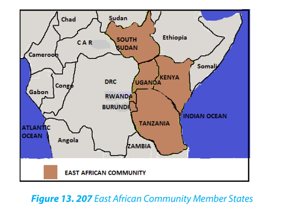
• To revive free movement of people, goods, money, and services.
• To create common (tax) tariff.
• To create large market for goods and services.
• To promote regional cooperation.
• To improve communication.
• To share electricity.
• To promote industrialization in the region
b. Economic Community of West African States
The Economic Community of West African States (ECOWAS). Established on May
28 1975 via the treaty of Lagos, ECOWAS is a regional grouping with a mandate of
promoting economic integration in all fields of activity of the constituting countries.
Member countries of ECOWAS include Benin, Burkina Faso, Cape Verde, Cote d’
Ivoire, The Gambia, Ghana, Guinea, Guinea Bissau, Liberia, Mali, Niger, Nigeria, SierraLeone, Senegal and Togo
• It has increased technological exchange among the member states.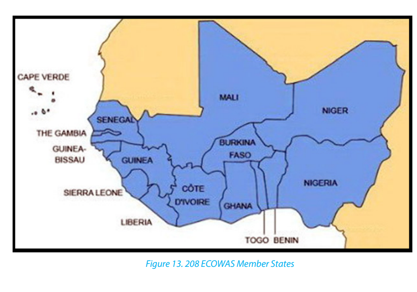 Objectives of ECOWAS
• To promote economic cooperation
• To uplift living standards of member states
• To achieve and maintain economic stability of member countries
• To enhance free movement in member states without immigration formalities.
This regional organization has achieved the following:
• ECOWAS has frozen all customs and tariffs on goods originating within West
African and this has led to industrial growth, pooling of resources through
joint ventures by certain member states.
• It has decreased prices among the member states of some products like
petroleum.
• There has been an improvement of communication in the region.
13.4.2. Trading Blocs
1. Organization of Petroleum Exporting Countries
The Organization of Petroleum Exporting Countries (OPEC) is an organization
of oil-producing countries. It controls 61 percent of the world’s oil exports and
holds 80 percent of the world›s proven oil reserves. OPEC’s decisions have a
huge impact on prices. The country members are: Algeria, Angola, Ecuador,
Gabon, Indonesia, Iran, Iraq, Kuwait, Libya, Nigeria, Qatar, Saudi Arabia, United
Arab Emirates and Venezuela.
OPEC’s three goals
• To keep prices stable. It wants to make sure its members get what a good
price for their oil. Since oil is a fairly uniform commodity, most consumers base
their buying decisions on nothing other than price.
• To adjust the world’s oil supply in response to shortages. For example, it
replaced the oil lost during the Gulf Crisis in 1990. Several million barrels of
oil per day were cut off when Saddam Hussein›s armies destroyed refineries
in Kuwait. OPEC also increased production in 2011 during the crisis in Libya.
• To coordinate and unify the petroleum policies of its member countriesand ensure the stabilization of oil markets.
2. The European Union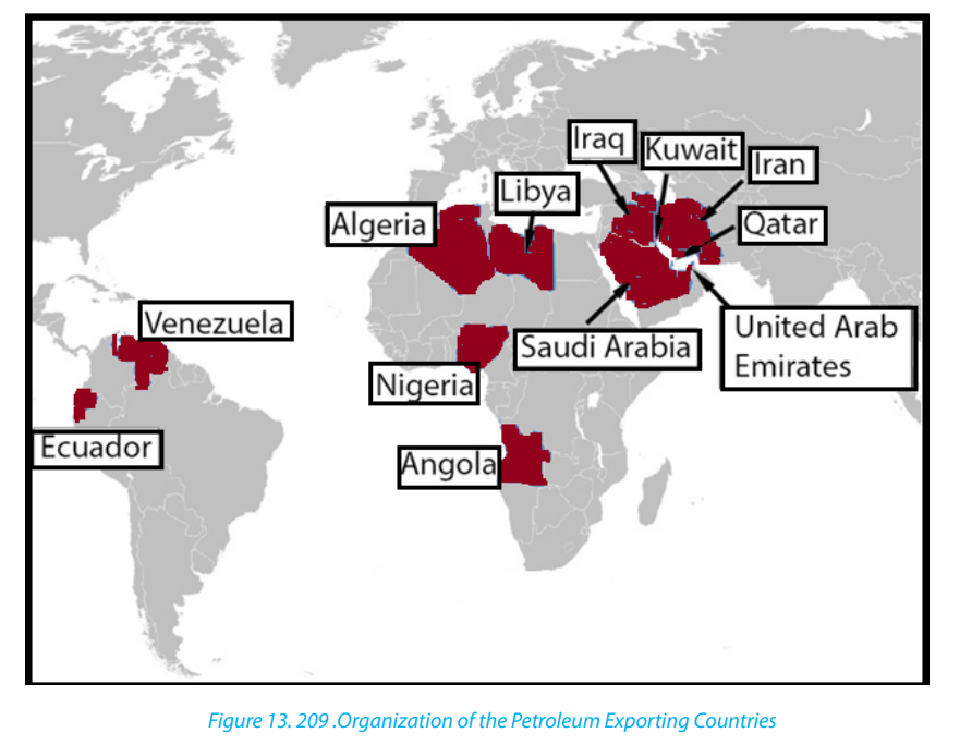
The European Union (EU) is a union of 28 independent states based in Europe.
It is the largest single common market in the world. The European Union has a
common currency, the euro, which is acceptable in all member states. EU helps
in promoting trade, agriculture and creation of employment.
Member states of the EU are Austria, Netherlands, Hungary, Belgium, Portugal,
Latvia, Denmark, Spain, Lithuania, Finland, Sweden, Malta, France, Poland,
Slovakia, Germany, Slovenia, The United Kingdom, Greece, Ireland, Italy, TheCzech Republic, Estonia, Luxembourg and Cyprus.
13.4.3. The Patterns of World Trade
The volume of trade, the direction of trade and the types of goods involved in the
trade vary greatly between different continents and individual countries.
i. Main Commodities involved in the World trade:• Food stuffs; grains, beverages, fruits, meat, spicesWestern Europe, North America and Japan are the major importers of raw materials
• Raw materials; fibres, rubber, timber, vegetable oils, metals and other minerals
• Fuels; coal, petroleum, natural gas
• Manufactured goods; textiles, machines, chemicals etc.
and foodstuffs. They are the major producers and exporters of manufactured goods.
These developed countries have invested heavily in developing countries which arethe main suppliers of agricultural raw materials, minerals and oil.
ii. Major Trading Zones of the World:Application activity 13.4.
The world’s major trading zones are:
• Western Europe: this is the most industrialized and the most densely populated
regions of the world. Its annual volume of trade is the largest in the world. More
than a third of the world trade is concentrated in European Union member
states.
• North America: Its foreign trade is second only to that of Western Europe. USA
has the largest economy in the world. The country has varied economy, rich
mineral resources, large concentration of industries and has heavily invested
in many developing countries. The other notable country of North America
which has been expanding its trade with USA and Western Europe is Canada.
• China: Has the second largest economy in the world after the USA. The country
has also one of the fastest growing economies in the world. It has expanded
its foreign trade in recent years. China has greatly increased its investments in
developing countries.
• Latin America: It is a major producer of food stuffs, minerals and a major
importer of manufactured goods
• Africa; The continent is less industrialized than other continents. Its main
exports to the industrialized countries are minerals and tropical raw materials.
Major imports are; manufactured products, consumer goods and mining
equipment.
• Southern continents: Australia and New Zealand are highly developed but
with a relatively small volume of world trade. The main exports are agricultural
products.
• Japan: It has the third largest economy in the world. The country is highly
industrialized. Its main exports include; manufactured goods, including steel,
ships, electrical goods and machinery, automobiles and chemicals. Its main
imports are oil from the Middle East, raw materials from Africa, Asia, Australia
etc.
• South-East Asia: This is an important trading zone. It produces tropical raw
materials such as; tin, rubber, timber, palm oil, petroleum from Malaysia and
Indonesia. Other important raw material producing areas from this region are;
Philippines, Burnei, Burma and Thailand.
• Middle Eastern states; This region possess more than half of the world’s
petroleum reserves. Crude oil and Natural gas are the main exports. In somecountries of the region oil represents 85 to 95 per cent of exports.
1. Describe the major aims of OPEC.End unit assessment2. Explain how ECOWAS member states have benefited from this integration.
1. Draw the map showing the member countries of E.A. C.
2. Conduct your own research to identify different regional integrations
operating with Rwanda and show their main objectives.
3. Examine the role of regional integration in the social, economic development
of Rwanda.
4. Analyse the reasons for low level of international trade in developing
countries.
5. What types of major commodities are involved in the international trade?
With reference to any two major commodities from different parts of the
world, explain geographical conditions which favour their production
and state two major countries for each of the commodities which import
them in large quantities.
6. With reference to either Western Europe or Africa discuss the geographicalbackground of its export trade.
UNIT 14 WORLD MULTIPURPOSE RIVER PROJECTS
UNIT 14: WORLD MULTIPURPOSE RIVER PROJECTS
Key Unit Competence:
By the end of the Unit, I should be able to evaluate the impact of multi-purpose river
projects on sustainable development of different countries in the world.
Introductory activity
Observe the image provided below and answer the following questions: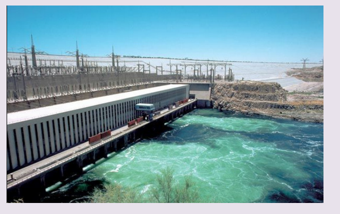
Aswan High Dam
1. What do you observe from the figure above?
2. What activity does that figure stand for?
3. Explain the two types of energy that you know and how they are
produced.
4. Explain how the Multipurpose River Projects contribute to the sustainabledevelopment of countries and socio-economic welfare of population.
14.1. Definition, aim, objectives and importance of multipurpose river
Projects
Learning Activity 14.1.Observe the sketch of a dam and answer the following questions:
1. List the elements found on this sketch of a dam.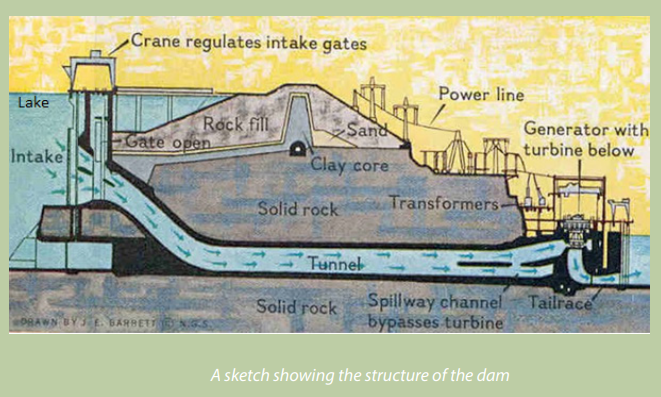
2. Make a research and define a Dam and explain its importance to humanactivities.
14.1.1. Definition, aims and objectives of multipurpose river projects.
Multipurpose River Projects: A Multipurpose River Project refers to the project
designed to use the water of rivers efficiently and improve its management for the
benefit of humans and their activities for the sustainable development of the regions.
These projects are based on dams built on rivers and they may be multipurpose,
involving more than one purpose, for instance water storage for irrigation, and
domestic uses, hydro-electric power generation, flood control, fishing, waterways
transport among others. Many hydroelectric power projects serve more than one
purpose, hence referred to as multi-purpose hydroelectric power projects. These
projects contribute greatly to enhance the sustainable development of countriesand the social economic welfare of inhabitants.
A dam: This is a constructed structure that forms a barrier across a river to regulate
the flow of water.
Aims of multipurpose river projects: The aims of the multipurpose river projects
are to increase the economic independence through the sustainable development
of various economic sectors, the national wealth and the standards of living of
inhabitants.
Objectives of multipurpose river development:• To control flood.Hydro-electric power plant (HEP): an hydro-electric power plant is constructed to
• To provide water for irrigation, diversify agricultural production.
• To check soil erosion.
• To provide water for drinking and domestic purposes.
• To generate electricity for industries, villages and cities.
• To provide inland navigation.
• To encourage tourism and recreation.
• To preserve wildlife.
• To develop fisheries.
• To create employment opportunities.
• To promote industrialization and urbanization.
• Diversify the economy.
• Creation of settlements for the landless/surplus population.
generate hydro-electricity for industries and homes. As represented on the figure
below, a hydro-electric power plant arrangement consists of basic sections such
as dam, reservoir, penstock, control gates, turbines, power house which includegenerator and transformer and power lines.
These basic sections are briefly described in the following: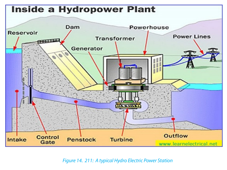
Dam: A barrier constructed across a river to hold back water and raise its level,
forming a reservoir used to generate electricity or for domestic, irrigation or industrial
water supply. Some dams are built also to preventing the flow of water or loose solid
materials (such as soil or snow).
Reservoir: The part of river where water will be stored is called Reservoir.
Penstock: Penstocks are generally made of reinforced concrete or steel to transport
water from reservoir to turbine with less friction losses.
Control Gate: Also called crane is used to control over the water travelling in
penstock.
Turbines: Water turbines are used to convert the energy of falling water into
mechanical energy and enable generators to produce electrical energy from rotating
shaft of turbine.
Power House: At the power house generated power from generator will be steppedup and supplied to transmission power lines.
14.1.2. Importance of multipurpose river projects for sustainable
development
The benefits of river dam projects for the sustainable development of countries
include:
• Provision of cheap and reliable hydro-electric power: Most river dam
projects in Africa are used to generate hydro-electric power for both domestic
and industrial purposes. This has saved valuable foreign exchange, which
would have been used to import thermal power. In developed countries,
hydropower costs less than most energy sources.
• Provision of water: The dams provide water for domestic, industrial and
irrigation uses for local inhabitants residing nearby. The water stored behind
dams is irrigation reservoir which helps in the growing of crops, especially
during the dry season. This has reduced farmers’ dependence on climate.
Irrigation farming can be carried out to increase food supply.
• River water is renewable source of energy: In contrast of other sources of
energy which are non-renewable because they are exhausted with time as
they are exploited (e.g. wood, coal, petroleum), multipurpose river projects are
mainly built on river water which is long lasting and one of renewable source
of energy.
• Development of tourism: Some multipurpose river projects can be of tourist
interests, thus earning foreign exchange, because river dam projects are
associated with features like impressive architectural designs, waterfalls, dams
and lakes which may be fascinating to the people that come to visit the places.
• Generation of government revenue: This is through taxation of workers’
incomes and earning of electricity and water boards.
• Employment opportunities: River dam projects create employment
opportunities for several people, especially those engaged in the production
of hydro-electric power and supply of water for domestic, industrial and
irrigated agriculture developed in the area. Provided employment raises
people’s standards of living.
• Industrial development: The projects have stimulated the development of
industries as there is ample power that is generated. This enabled the boost of
textile, brewing, sugar processing and steel rolling industries.
• Development of infrastructure: The projects have opened water transport
routes or shipping routes (river navigation). Many other infrastructures such
as development of towns, schools and hospital facilities among others havedeveloped within the river valley.
• Promotion of international relations: There have been joint ventures in the
development of river projects that have created co-operation among nations.
• Flood control: Dams are used to control flooding in flood-prone areas by
regulating the flow of water downstream.
• Reduction of importation: There is reduction on costs incurred on the
importation of fuel, manufactured products and foodstuffs since these arenow produced locally.
Application activity 14.1.
Knowing the aim and objectives of multipurpose river projects, explain why
such projects are so important for the sustainable development.14.2. Problems affecting Multipurpose River Projects
Learning activity 14.2.
If the Government of Rwanda decides to construct a dam to generate
hydroelectricity and water for industrial and domestic uses on river Nyabarongo,what problems can be faced by such a project?
The Multipurpose River Projects face many problems mostly in developing countries
for their implementation or maintenance due to the factors briefly explained below:
The projects are very expensive: The projects require large funds to support
construction activities. Limited resources especially in developing countries make
this difficult or even completely impossible. Attracting private investors for financing
multipurpose projects is difficult. Such projects also cause the displacement of
people. The resettlement of people who are moved from areas where dams are built
is very expensive. Once dams are constructed, in some instances there is insufficient
capital to purchase the spare parts needed for efficient maintenance of machinery
at the powerhouses.
The local people have little gain from the project: In some cases major benefits of
large multi-purpose river projects go to industrialists, while the local peasants have
little to gain.
Construction of dams causes ecological problems: The dams block the migration
of fish, upsetting the ecological balance and putting several aquatic species in
danger. The sudden release of large quantities of water from dams results in largescale
flooding downstream in low-lying plains. Large dams obstruct the free flow of
river aquatic animals such as fishes. Floating and invasive vegetation is likely to kill
the aquatic animals and vegetation.
Problem of shortage in skilled human resources: The establishment of
multipurpose projects requires availability of skilled human resources for
both construction of the project and maintenance of structures. These include
professionals with varied expertise such as civil mechanical and irrigation engineers,
hydrologists, and many other to be hired beforehand.
Changes in river regime: Some rivers do not have constant regimes and quite often
are characterised by seasonality and fluctuation in water provision. This renders
some projects unviable and unsustainable.
Accelerated soil erosion, water evaporation and change in ecological conditions:
Some projects may be dogged by siltation of dams, excessive evaporation owing
to increased surface area of created lake and change in ecological conditions.
Clearance of forests causes the destruction of water catchment areas of the rivers
feeding the dams. It further exposes the land to heavy rainfall which carries the top
soil away which is deposited in the lower courses of the river. Siltation of dam floor
may contribute to change in dam depth.
Large-scale irrigation may help in the spread of Bilharzia/Schistomiasis. Construction
of large multipurpose river projects leads to the formation of man-made lakes. Theselakes drawn rich agricultural lands ideal for crop production and human settlements.
Application activity 14.2.
Explain problems resulting from the development of multipurpose river
projects.
14.3. Solutions to the problems affecting Multipurpose River Projects
Learning activity 14.3.
Using geographical documents and internet, research on the solutions toproblems affecting Multipurpose River Projects.
In order to maintain the viability of the projects, some of activities to undertake• Establishment of the project based on accurate environmental conditionssuch as the characteristics of river regime and seasonal fluctuations, to avoidsituation where the project collapses soon after its establishment.• Training people to do the maintenance of the machinery and infrastructuresgenerated by the project. The lack of required home-grown skilled personnelcan be addressed if governments plan early enough and invest in the areaof human resource development, to improve their human resources capacityand thus reduce dependence on foreign expatriates who are always quite expensive to hire.• Continuous monitoring and evaluation of projects and taking correctivemeasures are needed.• Continued partnership and cooperation with donors and funding agencies toobtain soft or long-term loans with which to finance the project activities.• Fight and contain the spread of Bilharzia/Schistomiasis over irrigated projectareas.• Resettle the landless due to the drawning of agricultural land bythe manmade lake resulting from dam construction.
include:
• Removing in the waters the invasive species which are dangerous to aquaticlives.Application activity 14.3.
• Allow sufficient time and money for extensive public participation to ensure
that plans are optimal; that all sections of affected society are considered and;
that local institutions are in place to sustain irrigated agriculture, particularly
in respect of land and water rights;
• Afforestation: The increase of number of trees and vegetation protects the
water catchment areas of the rivers feeding the dams. This reduces the fluvial
erosion and other types of erosion which could damage the dams;
• Provide short-term support and/or skills for an alternative livelihood if irrigationremoves existing livelihood.
Discuss the impacts of multipurpose river projects in developing countries.
14.4. Case Studies
Learning activity 14.4.
Read carefully the text that summarizes the three case studies of multipurpose
river projects provided below and answer the questions that follow.
The Tennessee basin in USA was often devastated by floods and its economy
depressed because the pioneer settlers and their descendants farmed using
inappropriate traditional methods till the region became poverty-stricken. The soils
were eroded, hill slopes were treeless, rivers which were filled with silt eroded from
the surrounding hills became uncontrollable, causing huge floods on extensive
parts of the region and many damages to lives and properties. The Tennessee Valleybecame one of the poorest parts of USA in terms of economic wellbeing.
In 1933, the president Franklin Roosevelt signed the act to establish the Tennessee
Valley Authority (TVA). The TVA was created to become a regional economic
sustainable development agency to modernize various economic and social sectors,
including the development modern agriculture methods and industry, urbanization,
generation of Hydro electricity, increase employment opportunities in the region
The Akasombo Dam, built on River Volta in Ghana was mainly Hydro-electric power
oriented to supply industries and homes in the region. The project also aimed to
control and regulate the flows and recurrent flooding of the River Volta, to promote
agriculture through development of irrigated farming and communication, to
enhance fishing and to create employment opportunities for the population and
to improve the standards of living for the people in the area. In 1960, the Volta River
Authority (VRA) was established by Kwame Nkrumah, the 1st president of Ghana,
and was tasked to manage the development of the Volta River Basin, which included
the construction and supervision of the dam, the power station and the powertransmission network.
In Egypt, droughts and flooding of river Nile alternated. High-water seasons could
destroy the whole crop, while low-water seasons could create widespread drought
and associated famine. The project to construct Aswan High Dam in Egypt was
approved by The Egyptian President Gamal Abdel Nasser. It was mainly agricultural
irrigation oriented. In 1960 the construction began and was completed in 1976.
The project was conceived with aim to develop sustainably the country in various
economic sectors. The major objectives of the project are to prevent recurrent
flooding which affects the Nile valley, to control and provide a regular flow of
water for irrigation and increase the amount of irrigated land,
to generate HydroElectric Power for both domestic and industrial purposes; to create a man-made
lake (reservoir) where a fishing industry could be established, attract tourists and
increase employment opportunities.
Huang He basin in China is regarded as the cradle of Chinese civilization or the
“Mother River”, usually a source of rich fertile soil and irrigation water. Its waters and
the rich soil it carries bring agricultural abundance to support China’s enormous
population. The Yellow River, however, flooded more than 1,500 times in recorded
history into and swept away entire villages. For instance, in 1887, the river flood
killed an estimated 900,000 to 2 million people; in 1931, flood killed between 3.7
million and 4 million people. Another flood in 1943 washed away the crops in Henan
Province, leaving 3 million people to starve to death. Due to damages caused by
flooding waters, the river was given a name of China’s sorrow and ungovernable.
From 1950, China government began to build levees and dams to hold the Yellow
River back and control floods. The construction lasted over decades along Huang
He and its tributaries for multiple purposes including flood control, generating
hydroelectricity, promoting agriculture, developing industries and cities for a
sustainable development of the region. Now answer the following questions:1. 1. Identify the common problems faced by countries mentioned above14.4.1. The Tennessee Valley Authority (USA)
before the establishment of multipurpose river projects.
2. 2. Identify common objectives found in multipurpose river projects of
respective countries.
3. 3. Based on the text above, explain why a country can decide to construct
a multipurpose river project.
i. Aims of The Tennessee Valley Authority
The Tennessee Valley Authority (TVA) is a corporation formed for large-scale
rehabilitation of a vast region which includes parts of seven adjoining states of
Tennessee, Kentucky, Virginia, North Carolina, Alabama, Georgia and Mississippi,
in the United States of America (USA). The Tennessee Valley Region is drained by
the Tennessee River and River Timberland, both tributaries of the Ohio River
which is a tributary of Mississippi River. The drained area is about 106,000 km².
Due to persistent flooding and soil erosion which marked the Tennessee basin
for centuries, President of the USA, Franklin Roosevelt established in 1993 the
Tennessee Valley Authority (TVA) to rehabilitate and to develop the entireregion which was then one of the poorest parts of the USA.
ii. Problems faced by the region before the creation of TVA
The region covered by TVA presented several problems for which urgent
solutions were needed. The problems faced by the project include the following:
• Severe soil erosion: This was caused by poor methods of farming, deforestation
on steep slopes and rapid population increase. These factors exposed the soil
to erosion and running water created deep gullies in the area.
• Silting and flooding: They were so severe on Tennessee River and its tributaries.
Tributaries often flooded causing recurrent deaths and destruction of
properties.
• Famine: These were common among the local population. This is because the
fertile top soils had been eroded leading to low and poor yields.
• High population growth: The pressure to get more land for cultivation caused
clearance of forests. The continued traditional farming methods caused the
exhaustion of soil nutrients.
• Poor housing facilities: The local administration authorities could not afford
to provide sustainable and enough housing units and this caused the lack of
decent accommodation.
• Poor living standards: Unemployment and poverty were widely spread in the
area and people were not able to afford basic needs of life.
• Problem of transport: During periods of heavy rains, the rivers flooded and the
transport of people and goods was compromised.
• Lack of fuel: There was severe shortage in fuel resources especially due to rapid
deforestation within the region.
• Epidemics: Outbreak of diseases such as malaria and bilharzia attacked
population due to constant flooding in the area.
• High government costs: Government expenses were very high especially insupply of food and drugs.
iii. Strategies taken by the USA central government to solve the problemsStep 1: Assignments tasked to the Tennessee Valley Authority
Strategies taken to solve the problems in Tennessee region were sequenced in
various steps:
The following tasks were assigned to Tennessee Valley Authority when it was created:• Building dams to control flooding of River Tennessee and its tributaries andStep 2: Concrete actions taken to control soil erosion
later generate hydro-electric power. The generated electricity would be
exported to other neighboring states thus reaping revenue for the state.
• Controlling severe soil erosion by putting in place sustainable conservation
measures, and mechanisms for reclaiming badly eroded lands and flooded
swamps in the area.
• Promotion of forestry through afforestation programs. These programs aimed
to reduce flooding and soil erosion in the area.
• Improvement of the transport facilities such as roads, railways and water
transport whose construction and maintenance were hindered by floods.
• Promotion of the industrial development to increase alternative employment
opportunities to the people in the area, in the agriculture sector and industrial
sector.
• Teaching inhabitants better farming methods to improve sustainably
agriculture in the region.
• Providing enough and sustainable housing to accommodate the rapidly
growing population.
• Conserving wildlife in the area.
• Controlling the spread of diseases such as malaria and Bilharzia that resultedfrom floods.
The following are concrete conservation measures taken by TVA to control soil
erosion:• Training of farmers: Experts were hired from outside the local area especially
from other agriculturally advanced regions of USA like California and Southern
USA to educate local farmers on how to improve their farming methods;Step 3: Construction of Dams and resultsand better farming methods such as mixed farming and crop rotation;• Creation of demonstration farms: aimed at giving advice to farmers on modern
• Re-afforestation programs: These were undertaken to plant young trees on
ridges and hills. Their roots would bind the soil particles together and absorb
excess water which was previously running off;
• Filling the Gullies: gullies were covered with brushwood to cover and trap soils
and stones and eventually fill up the gullies;
• Terracing: this involved the cutting of a series of wide steps and construction
of embankments on hilly slopes to reduce gradient and surface runoff;
• Introduction of modern farming methods: farms were mechanized in order
to increase the production. The use of fertilizers and manure to maintain soilfertility was also applied.
• Several dams were constructed: Nine dams were constructed on the main
Tennessee River and 23 on its tributaries. The major ones along the Tennessee
River include Noris, Cherokee, Fontana, Chickamauga, Willson, Pickwick, Fort
Loundon, Douglas, Kentucky, Guntersville, Hirwassee and Walts bar. All the
dams can control floods, storing water, assisting navigation and generating
hydro-electricity.
• The huge reservoirs created by the dams hold back enormous quantities of
water: This reduced greatly the flood heights, and since then this water is
released for irrigation purpose or holds water for navigation.
• Elimination of swamps: The management of swamps resulted in a complete
elimination of malaria and bilharzia
• Development of tourism: Natural parks and man-made lakes were created.
Camping, canoeing and hunting have been promoted. The scenic beauty
around dams recreation facilities at wildlife reservations attract more touristsand increase foreign exchange.• Supply of Electricity to industries: The TVA also directs the storage and release
of water and generation of power at four dams owned by the AluminumStep 4: Construction of important infrastructures and industriesCompany of America (ALCOA).
The major infrastructures and industries constructed include:• Electric Power Station and urban development: Constructed power stationsin Alabama State, Atlanta in Georgia and many others across the region. Bystimulated the growth of urban centres, for example, Memphis and Birmingham
1953, 80% of homes in the region were electrified, compared with 3% at the
beginning of the project in 1933. Today the full-scale rural electrification has
been a great achievement for the TVA.• Transport Infrastructures: Roads, air and railway transport networks were
constructed in the region. Navigation on created dams on Tennessee and
transportation of freights and passengers over a distance of 1.050 km are
known to be among the most efficient worldwide.
• Educational and research institutions: Various Institutions of learning such as
Universities, Colleges and Schools were constructed in Tennessee Region. All
research centres were established with linkage to universities and colleges.
• Industrial centres: Industries were constructed to generate employment
opportunities to the people. Major industries include Aluminum manufacturing,
fertilizers industry like phosphates, paper mills, chemicals, pharmaceuticals,
automobiles and food processing plants.
• Health centres and hospitals: Several health centres and hospitals were
constructed to improve the health of states within the Tennessee catchment
area. These are able to serve not only the seven states of the region, but theinternational community as well.
iv. Benefits of TVA for sustainable development of the region
TVA projects strongly stimulated the development of all social, industrial,
economic, educational and cultural sectors. There are many benefits that
resulted from this multipurpose Tennessee project. The following are some of
them:
• The control of floods and soil erosion has been successfully and sustainably
mastered.
• Cheap hydro-electric power was availed: This attracted diversified industries
that offered employment within the Tennessee valley.
• Diversified food products: Milled grains, baked foods, confectioneries and
beverages and many others are produced in the region.
• Local farmers joined the established demonstration farms: Farmers were
trained on better farming methods to control soil erosion and increase crop
yields.
• Diversified and improved transport networks: This encouraged significantly
the local and international commerce.
• Many and diversified industries in the region process ores and other rawmaterials: Raw materials that were formerly processed in the North East of USAiv. Benefits of TVA for sustainable development of the region
are now processed in the Tennessee region.
• Tourism was greatly promoted: The region covered by TVA earns the
government of USA foreign exchange as a tourist attraction destination;
• The production of motor vehicles, boats and aircraft parts: Constitute
Tennessee’s largest industry in terms of contribution to overall TVA’s stateseconomies.
TVA projects strongly stimulated the development of all social, industrial,
economic, educational and cultural sectors. There are many benefits that
resulted from this multipurpose Tennessee project. The following are some of
them:• The control of floods and soil erosion has been successfully and sustainably
mastered.
• Cheap hydro-electric power was availed: This attracted diversified industries
that offered employment within the Tennessee valley.
• Diversified food products: Milled grains, baked foods, confectioneries and
beverages and many others are produced in the region.
• Local farmers joined the established demonstration farms: Farmers were
trained on better farming methods to control soil erosion and increase crop
yields.
• Diversified and improved transport networks: This encouraged significantly
the local and international commerce.
• Many and diversified industries in the region process ores and other raw
materials: Raw materials that were formerly processed in the North East of USAare now processed in the Tennessee region.
• Tourism was greatly promoted: The region covered by TVA earns the14.4.2. Akasombo Dam – The Volta River Project (Ghana)
government of USA foreign exchange as a tourist attraction destination;
• The production of motor vehicles, boats and aircraft parts: Constitute
Tennessee’s largest industry in terms of contribution to overall TVA’s stateseconomies.
i. Location and site of Akasombo DamThe construction of the Akasombo Dam was the first Ghanaian project
undertaken by the Volta River Authority (VRA) in 1960. The dam is located
on River Volta near the Akasombo town in southern Ghana. The site has been
chosen because it was where the river valley was narrowest and surrounded bya rock strong enough to hold the dam.
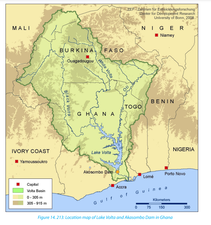
ii. Aims and objectives of the project
The project aimed at constructing Akasombo Dam and Volta Lake, one of the
longest man-made lakes in the world. The dam is 111 m high and 660 m long
at the top and 366 m at the bottom. A man-made lake; called Volta Lake, was
formed behind the dam covering an area of 8502 sq.km. The Lake extends for400 km with a shoreline of 7,250 km.
The dam was built with the following objectives:
• To provide cheap electricity to run the smelter: called Volta Aluminum
Company (VALCo) located at the new port of Tema and to increase the Ghana’sdomestic and industry supplies of power.
• To control and regulate the flows and recurrent flooding of the River Volta.
• To promote agriculture through development of irrigated farming but also to
provide a major inland waterway.
• To construct the Lake Volta to enhance fishing and supplement population in
animal proteins.
• To create employment opportunities for Ghanaian population to improve thestandards of living for the people in the area.

iii. Factors favouring the establishment of the Akasombo river project
Both natural, human and economic factors contributed to the establishment of
Akasombo Dam project. The most important factors are given in the following
paragraphs:• The heavy and well distributed rainfall provides regular and reliable supply ofiv. Importance of Akasombo Dam
water in Volta basin. This makes the flows more regular and energy produced
relatively constant.
• The availability of land. The region around Akasombo is sparsely populated.
• The hard basement rocks provided a firm foundation for construction of the
dam.
• The River Volta crosses a narrow gorge located at Akasombo valley in the south
eastern part of Ghana where River Volta cuts through Akwapin hill.
• A large market - There is high demand for the power generated for both
industrial, especially the Volta Aluminum Company (VALCo) and for domestic
use, and high demand for other products from the multipurpose project.
• Foreign investors - the foreign investors especially from USA and Britain
provided a support in form of skilled labour.
• The availability of capital to construct the complex to provide power and set
up flood controls, from the World Bank and Britain.
• The creation of Volta River Authority (VRA) whose primary task was to manage
the development of the Volta basin, which include construction and supervision
of the dam, the power station and the power transmission network.
• The government policy to develop a large-scale multipurpose project topromote economic development.
The construction of Akasombo Dam resulted in numerous benefits which
contributed greatly to increase the government economy in various sectors
and improved the welfare of population. The following are some of them:• Hydro-electricity production promoted industries, port cities and international
co-operation.
• The generation of hydro-electric power (HEP) has significantly reduced the
expense of importing petroleum oil for thermal power stations thus saving
foreign exchange.
• Cheap electricity is supplied to VALCo smelter.
• Ghana can process much of the bauxite (Aluminum ore) instead of shipping it
in raw state which is bulky.
Akasombo dam allowed the development of numerous industries at
Tema, Accra, Tokoradi and Kumasi cities. Industrial development has
enabled Ghana to become less dependent on import of some food stuff
and to process locally some of agriculture products, e.g. cocoa.
• It has enabled the development of ports and urban centres. For instance,
Tema is an industrial city home of the Aluminum smelter. Other centres suchas Accra, Takoradi offer a wide range of social and economic services.
• The dam supplies electricity to Ghana’s neighbors such as Togo, Benin andv. Problems associated with the Akasombo dam project
Ivory Coast. This has strengthened economic co-operation between Ghana
and her neighbours.
• Development of transport, fishing and tourism.
• Irrigation has promoted agriculture. New farming activities developed along
the shorelines of Lake Volta as it became valuable resource for irrigation. It is
a potential source for irrigation which enabled Ghana to grow various crops
among others such as rice, sugarcane, maize and vegetables.
• Farming has greatly improved and diversified. The Akasombo Dam and Lake
Volta are great tourist attractions which bring in foreign exchange.
• The project has generated employment opportunities to many people, for
instance, people involved in the distribution of electricity in the cities of Accra,
Tema, Tokoradi and others.
• The project has raised the people’s standards of living and has helped in the
diversification of the economy from being predominantly agricultural toindustrial, mining, fishing and tourism, hence multipurpose development.
The following are some problems have been reported as the consequences of
the project:
a. Flooding of traditional farm lands and displacement of people and
properties• The construction of Akasombo Dam was completed in 1965. Water floodedb. Inadequate power supply
traditional farm lands behind Akasombo Dam, and 80,000 people were
displaced with 200,000 animals belonging to them. The flooding was caused
by the rising water of the Lake Volta, the largest artificial lake in Africa. 120
buildings that made up 700 villages prior to resettlement were abandoned
and destroyed. The impacts on the environment was so great in such a way
the natural vegetation, animals, road networks in the area covered by the Lake
Volta were submerged.
• There was high cost of resettlement. The displaced population did not like the
houses that were provided and had no money to improve them. Relocated
population was not happy with the allocation of new lands. People resented
the loss of their old farm lands in which they could grow vegetables or keepgoats.
• Initially, the dam’s power production capacities greatly overreached the actual
demand. Due to the development of H.E.P., other power sources lost market,
which discouraged other producers.
• Since the dam’s inception, increasing demands for power exceeded what can
be provided by the current structure and resulted in the doubling of hydropower production needs.
• The Volta Aluminium Company needed a lot of power for smelting Aluminium
and it consumed more than half of the power produced, so several areas were
deprived of the use of electricity.
c. Seasonal lowering lake levels and decreasing in power output
• A trend of lower lake levels has been observed, sometimes below the
requirement for operation of the Akasombo dam. During periods of drought,
there is reduction in the lake levels which decreases the expected power
output. For instance, in the beginning of 2007, there were great concerns over
the electricity from the Akasombo dam due to lower water levels in the Lake
Volta reservoir.
d. Environmental and economic problems
• Lake Volta became a habitat for disease vectors like water snails and mosquitoes,
which are found in stagnant water, this led to spread of bilharzia and malaria
respectively.
• It has been reported that the lake floor is being silted by sediments, which
reduce the depth and the water storage capacity of the lake.
• The creation of the Lake Volta in the centre of the country, divided the country
into two, e.g. East and West. This became a barrier to communication.
• The development of industries such as Aluminum smelter and oil refining at
Tema led to environmental pollution.
• Since there was less power available for domestic use and others uses, high
prices were charged for electricity and it became expensive to many people.
• The development of the project has been dependent on overseas finance,
and the companies like VALCo were mainly concerned with their commercialinterest and hence profit repatriation.
vi. Solutions to problems resulted from Akasombo DamMany solutions have been envisaged to solve problems that resulted from the
construction of Akasombo Dam. These solutions are briefly highlighted and
described below:
• The dam’s power plant initially opened with four units, with a total installedcapacity of 588 MW. This was upgraded in 1972 with the Addition of two
units to generate 912 MW. These two units were upgraded in 1999 and14.4.3. Aswan High Dam (Egypt)
2005 respectively to generate additional 170 MM each increasing the total
generation capacity of the dam to 1,020 MW.
• 80 % of electricity generated by the dam is supplied to the America-owned
Volta Aluminium Company (VALCo), while the remainder is supplied to Ghana
and her neigbours, mainly Togo and Benin.
• By 1981, a smaller dam was built near the town of Kpong, downstream from
Akasombo. This project aimed to generate an addition 400 MW of power
to that produced by Akasombo dam, to supply local industries and socioeconomic activities.
• Further upgrades to Akasombo have become necessary for maintaining
hydropower outputs.
• The 80.000 people displaced due to the construction of the project wereresettled into 52 resettlement villages.
i. Aims and objectives of the projectAswan High Dam is located in southern Egypt, on River Nile. The construction
of the dam started in 1960 and was completed in 1970. The dam is about 3830
metres long and 111 metres high. Its base is 980 metres wide. The completion
of the construction resulted in the creation of a man-made lake known as Lake
Nasser, one of the longest reservoirs of the world. The reservoir was named after
Abdel Nasser, the president of Egypt at the time. The lake covers an area about
550 km long and 16 km large. Lake Nasser is 35 km at its widest and has 5,250
sq. km. The lake extends into Sudan. The dam generates 2,100 megawatts (MW)of electricity and is able to resist by its weigh the great pressure of River Nile.

The project to construct Aswan High Dam was conceived with aim to develop
sustainably the country in various economic sectors. The major objectives of the
project are:• To prevent recurrent flooding which affects the Nile valley during the rainy
season, mostly in August and September.
• To control and provide a regular flow of water for irrigation, during both the
dry and rainy seasons.
• To enable the country to grow enough food to feed the growing population.
• To increase the amount of irrigated land.
• To generate Hydro-electricity Power for both domestic and industrial purposes.
• To create a man-made lake (reservoir) where a fishing industry could beestablished.
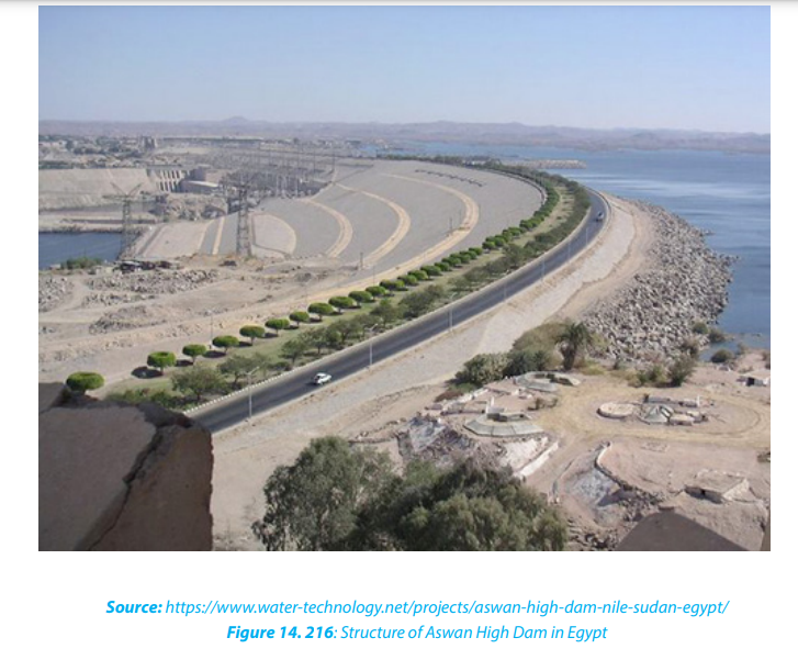
ii. Factors favouring the construction of Aswan High Dam
The success of the construction of the Aswan High Dam was a result of a
combination of the following factors:• Strong basement rock: The dam was constructed where a strong basement• Advanced technology involved in the general work of dam construction which
rock to support heavy dam structures existed. This provided a firm foundation
for the dam.
• The channel was narrowed where the dam was constructed. This made the
construction cheaper and easier.
• Presence of large capital invested: The construction and the maintenance of
the dam were made possible by funds provided by the Soviet Union and Egypt
goverments.
• Availability of skilled labour: Russian experts and egyptians semi-skilled labourwere hired to construct the project.
included strong turbines which produce high power voltage.
iii. Importance of Aswan High Dam for the sustainable development of the
region
The Aswan High Dam Project has contributed greatly to the Egyptian economy
and the welfare of rural and urban population. This became a source of
government revenues, creation of employment opportunities for many people.
The importance of Aswan High Dam can be summarized in the following:• Flood control: The dam enabled the control of floods and regulated the flow
of the River in the Nile valley. People’s lives and properties are safe in the Nile
valley. This saved money which was formerly spent on displaced people. The
reservoir created provides water in times of droughts.
• Production of Hydro-electric power (HEP): Aswan High Dam has an output
of about 2100 MW. The production of (H.E.P). has led to the development of
diversified industries in the region, such as iron and steel, textiles; mining
industries especially oil drilling (Petro-chemical) and sugar refining especially
in Cairo and the free zone area of the Nile delta. The establishment of industry
has created employment opportunities to the majority of local Egyptians.
• Provision of power for domestic purpose: There has been a program of rural
electrification, especially along the Nile and in rural villages because of the
presence of the Aswan High Dam.
• Improvement of agriculture sector: Irrigated land area of Egypt has increased
by 25 percent since Aswan High Dam is established. Farmers can now grow
several crops in the year, such as maize, wheat, barley vegetables and others.
• The water in the region is supplied on regular basis: L. Nasser holds with
80 % of its water going to Egypt and 20 % to Sudan. The water stored is used
for irrigation.
• Promotion of fishing: Lake L. Nasser has promoted the fishing industry,
• Promotion of tourism: The Aswan High Dam and Lake Nasser are tourist
attractions. This enables to earn foreign exchange.
• Reduction of costs to import fuel: The construction of the dam has resulted
into a significant reduction of costs incurred on the importation of fuel
petroleum products.
iv. Problems associated with the construction of the Aswan High Dam
The construction of Aswan High Dam involved a number of problems. The most
important are briefly presented below:
400 Geography Senior Six Student Book• There was displacement of people and their livestock: 42,000 people who
used to live in the region that is now covered by Lake Nasser were evacuated
1,300 km by rail across Nubian Desert to Khasm El Gibra.
• A lot of cost for resettling displaced people: Much fund was involved to
relocate people since they were given double their foremen hectares of land
and the irrigation and electric power had to be provided from the new dam.
• Pollution of water, soil and air: this was due to the establishment of industries
in the area.
• Increase of diseases like bilharzias and malaria: The outbreak of these
diseases was caused by stagnant water, This causes great expense to the
government economy in treating its people.
• High evaporation of water: It is estimated that 25% of water is lost through
evaporation because of high temperatures. The high evaporation rates lead to
increased saline deposits in the soil which are associated with decreased yield.
v. Solutions to the problems associated with Aswan High Dam
Some solutions have been put forwards to solve problems caused by the Aswan
High Dam.• Regular dredging is carried out to remove waste matter which affect the14.4.4. Huang He River Project (China)
drainage of the new valleys.
• Treatment of waste (recycling) is performed before their disposal. Some
environmental laws have been set to regulate dumping in the river.
• Construction of levees to control overflow of water that resulted in floods.
• Use of ferry and steamers to ease the communication around Lake Nasser.
• Spraying to control diseases such as Bilharzia spread by snails from the
stagnant water which gives a breeding ground for them.
• There is a legislation against brick making along the river bank.
• Farmers are sensitized to the use of organic manure as opposed to inorganic
fertilizers to reduce salinity and soil pollution.
• Sensitization of population for new settlement plans: There has been a general
sensitization for new settlement along the river bank against dumping of
garbage in the river which is partly responsible for making the river burst itsbanks.
i. Location of Huang Ho River
Huang He called the Yellow River (formerly known as the Hwang Ho), is located
in China. The river originates from the Northern part of mount Bayan Ha of
Tibet plateau in Qinghai province and runs Eastwards, a distance of 5,464 km to
empty in the Bo-hai Sea at Shantong.
The river flows through 9 provinces namely Qinghai, Sachuan, Ganso, Ningxia,Inner Mangolia region, Shanxi, Shaanxi and Shanang.
The project Huang Ho Basin Development covers parts of provinces highlighted
above, over an area of 750,000 km2. The main tributaries of the Huang Ho in its
lower riches include Taohe, Jighe, Welhe, Luohe, Fehhe, Yihe and Qinhe. The Huang
Ho River is China’s longest and largest river after the Yangtze River, with over 30
tributaries feeding it.
Huang He is a shifting, turbulent and silt laden stream that often overflows its banks
and sends its flood waters across the North Eastern China’s plain. It gets nearly 45 %
of its water from glaciers and vast underground springs of the Qinghai-Tibet Plateau.
The word Huang means Yellow. It refers to the color of the river‘s waters, for the rivercarries a heavy load of silt.
ii. Problems faced in Huang Ho Basin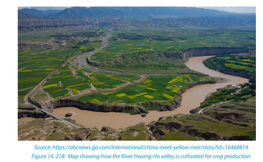
The following are some of challenges faced in the Huang He basin:
• Several foods along the Huang He River: The flooded areas of Huang Ho
valley suffered from considerable damage to life, housing and properties,
transport and communication. The flood problems are often exacerbated by
deforestation. About 500 people die from them in Yunnan province alone. In
September 2003, torrential rains and floods destroyed 17,000 homes in
Hennan Province and forced more than 200,000 to flee their homes in Hennan
and neighbouring Shaanxi Province. Floods trigger mudslides, cutting of
power and telephones, destroying roads and bridges. These caused stresses,
famine and spread of diseases among people.
• Severe soil erosion and large silt load: The river carries a large amount of
soil. It was estimated that every cubic metre of Huang He contains 37, 6 kg of
silt. The heavy load of sediment causes the yellow river to constantly deposit
the soil along the bottom of the channel which raises the bed, contributing to
the floods.
• Irregular flow and change of river course: The amount of river discharge
depends on the seasonal variation of the river regime which is high in volume
in the rainy season and low discharge in the dry season. When floods occur,
the river breaks out of the levees into the surrounding lower flood plains and
adopt a new course, which result in more damage to people living in the lowerreaches.
• The river faces a threat of drying up: The Huang He River has dried up more
than 30 times since 1972. Increased drying up is caused by increased storage
surface of water due to the construction of dams, and the flowing of the river
through a desert dry land of Tengger desert and Ordos desert.
• High population growth rate: This created pressure on land by an increased
agricultural irrigation. There is also an increased demand for the river water
owing to population increase.
• Problem of pollution: Huang Ho River faces the problem of pollution.
The river crosses the major coal producing industries areas and huge
population centres. Over 4,000 .petrochemical factories are located
in Huang Ho river basin,and all of the fish species found in the Huang
Ho have become extinct becauseof dams, falling water levels,
pollution and over fishing.
iii. Aims and objectives of Huang Ho Basin Development project
In 1950 the government of China created a multipurpose project called “Huang
Ho Basin Development”. The major aim was to control devastating floods and
to sustainably develop areas around the yellow river.
The major objectives of the project are meant:• To reduce the risks of flood to lives and properties;
• To produce energy and increase the discharge during dry periods;
• To retain silt and store water for irrigation;
• To provide water for home consumption and industries.iv. Importance of the project
The Huang-Ho Basin development project is of outmost importance for China
in various economic sectors. The project has contributed to the sustainable
development of the region, as briefly presented below:
• Several dams were built: over 40 dams were built along Huang He and its
tributaries to regulate the flows of water and to produce hydro-electric energy.
Activities of construction were sequenced between 1960s and 2010s. The most
documented hydroelectric power stations of the project include Sanmenxia,
Xialangdi, Sanshengong, Qintong Gorge, Luijiiaxia, Lijlaxia Dam, Yuanguoxia,
Lianqio, Bapanxia, Da George Dam, Li Geong Dam, Wanjiazhi Dam and LaxiwaDam.
• Development of cities and settlement centres: Several cities were created
and greatly expended in the Huang He basin (see the map below). More than
400 million people have settlements in the Huang-Ho river basin. This was
possible because of the multi-functional projects focusing on the development
of traffic (roads, navigation on Huang-ho River year round), ecology, economic
and flood prevention for the cities along the river that attract people to settle
in the area for employment opportunities. The most important cities arerepresented on the map below.
 • Creation of reservoirs: Some dams were created with the main purpose ofindustries have developed in the region, such as petrochemical factories and
storing water. For instance Longyang gorge, Liujia Dam, Xialangdi Dam
• Floods control: The regulation of rivers’ flow has virtually eliminated floods
that regularly submerged the northern china’s plain.
• Food production: The crops grown are rice, wheat, maize, soyabeans,
potatoes, sweet potatoes and cereals. This uspports a large population living
along the river basin.
• Remarkable expansion of irrigation: Irrigation of the dry areas of the
northern part of China was made possible with the help of the Huang-Ho
River. irrigated area increased from 0,8 million hectares in 1950 to 7.5 million
hectares in 2000.
• Tourist attraction: Many tourist centres along Huang He promote the tourism
industry. The touristic features include the Hukou falls in Shaanxi, the caves,
stone statues and the Huang-Ho river dams, among others. Tourism is a major
foreign exchange earner in China.
• Industrial development is facilitated by the Huang-Ho River. A number of
mining industries. The river provides significant amounts of water to industries
to cool the machines.
v. Challenges
The area faced, however, challenges associated with water crisis. Some of
problems are briefly presented below:• Increased rate of water demand and use resulting from high populationvi. Measures to solve problems related to water shortage
growth and regional economic development caused the drying up of the flow
of the river.
• Parts of the river especially in mountain area remain frozen in winter season
during which water remains frozen, and the water supply from precipitation
is limited.
• The Yellow river crosses some arid and semi-arid region. Thus precipitation
and water sources are limited.
• The land surface change from slope land to terraces has involved expansion of
irrigation activities which affected the regional hydrology and rive flow.There is a water transfer from the South to the North project to channel throughApplication activity 14.4.
the ground canal from River Yangtze where water sources are relatively rich inthe South to the Huang Ho where water resources are limited.
1. Discuss the problems faced by the region before TVA project was created.End unit assessment
2. Discuss the strategies used to solve identified problems in the region of
concern.
3. Explain the benefits of TVA projects.
4. Identify aims and objectives of multipurpose river projects in the studied
countries.
5. Compare factors that favored the construction of multipurpose river
projects in Ghana and Egypt.
6. Based on each of the case studied in this lesson, compare problems faced
by respective countries before the establishment of multipurpose river
projects.
7. Based on each of the case studies analyzed above, explain problems that
result from multipurpose river projects in both developed and developingcountries and how these problems are solved.
1. Describe the benefits and the challenges of multipurpose river projects,
and suggest ways to overcome those challenges.
2. Compare the importance of Tennessee Valley Authority and Huang He
Basin Development project in the sustainable development of USA and
China respectively.
3. Referring to Aswan and Akasombo dams, explain how multipurpose river
projects can contribute to the sustainable development in the other
developing countries.
4. Discuss the economic impact of Tennessee Valley Authority and Huang He
Basin Development Projects to their respective countries.
5. Considering the requirements of constructing a multipurpose river project,
identify the factors that can favour or limit such project in Rwanda.
6. Based on the case studies studied in this unit, explain the economic
advantages that Rwanda would benefit if it had constructed a multipurposeriver project.
UNIT 15 ENVIRONMENTAL CONSERVATION AND TOURISM
UNIT 15: ENVIRONMENTAL CONSERVATION AND
TOURISM
Key unit competence:
By the end of this unit, I should be able to evaluate the impact of conserving natural
resources and tourism on the sustainable development in the different countries of
the world.
Introductory activity:
Observe the photograph below and answer these questions:
1. Identify the economic activity taking place in the photograph.
2. Describe the vegetation shown in the foreground of the photograph.3. Why is it important to conserve wildlife in national parks?
15.1. Definition, components and factors of environmental degradation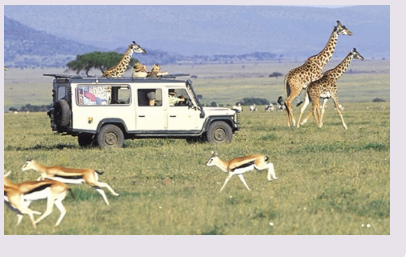
Learning activity 15.1:
a. Identify the physical features shown on the photograph above.
b. Explain human and physical factors that accelerate environmentaldegradation.

a. Definition of the environment
The word Environment is derived from the French word “Environ” which means
“surrounding”. Ordinarily, environment refers to all things that surround us. Our
surrounding includes biotic factors like human beings, plants, animals, microbes
and abiotic factors such as light, air, water, soil, etc.
Environmental degradation refers to the deterioration of the Earth’s natural
surroundings because of excessive exploitation of the available resources: water, air,
flora, fauna, soil etc.
Environmental conservation is the act of protecting the environment againstdestruction.
b. Components of the environment
- Abiotic environment: It includes all non-living things like rocks, minerals,
water, weather conditions.
- Biotic environment: It includes all living things like plants, animals, Microorganisms.
c. Factors responsible for environmental degradation:
• Overpopulation: Rapid population growth puts strain on natural resources
which results in degradation of our environment. Mortality rate has gone
down due to better medical facilities which have resulted into increased
lifespan. A big population simply means more demand for food, clothes and
shelter. You need more space to grow food and provide homes to millions of
people. This results into deforestation which is another factor of environmental
degradation.
• Pollution: Pollution, in whatever form, whether it is air, water, land or noise is
harmful for the environment
• Deforestation: Deforestation is the cutting down of trees to make way for
more homes and industries. Rapid growth in population and urban sprawl are
two of the major causes of deforestation. Apart from that, use of forest land
for agriculture, animal grazing, forest harvesting for fuel wood and logging are
some of the other causes of deforestation. Deforestation contributes to global
warming as decreased forest size puts carbon back into the environment.
• Swamp reclamation: The extensive drainage of swamps or wetlands has
serious effects on the environment. This has resulted into inadequate water
supply and the drained areas soon become arid.
• Bush burning: This is done by different societies for different reasons. Burning
of the vegetation results into the land being left bare thus the exposure of the
top soil to wind and running water hence erosion and soil deterioration.
• Urbanization: Urbanization refers to the increase of population in urban
areas and the horizontal expansion of urban areas. Urbanization is, therefore,
associated with the expansion of the city over the natural environment, the
increase of traffic congestion, smoke, acidic rainfall, global warming, etc.
• Extraction of minerals: Mining and quarrying of rocks lead to exhaustion
of minerals, destruction of scenery beauty, increased pollution, mining
operations release effluents that contaminate water.
• Natural Causes: Things like avalanches, quakes, tidal waves, storms, and
wildfires can destroy nearby animal and plant groups to the point where theycan no longer survive in those areas.
Application activity 15.1
Compare the main factors of environmental degradation between the city ofKigali and the Northern province of Rwanda.
15.2. Consequences of environmental degradation, methods of
environmental conservation and importance of environmentalconservation.
Learning activity 15.2:
1. Observe the photograph above and identify the phenomena that took
place in this area.
2. Explain the effect of the human activity shown on the photographabove on the environment.
a. Consequences of environmental degradation
• Deforestation reduces rainfall, drives climate change and desertification. This
creates severe climatic conditions that impact on various human activities
mainly agriculture.
• Flooding destroys agricultural land, crops, loss of properties, lives and
contaminates safe drinking water.
• Accelerated soil erosion due to deforestation making the land to become
unproductive.
• Increased landslide leads to large expanses of bare land and this limit human
occupancy.
• Silting of rivers, seas and oceans this has led to reduction in size of water bodies
and this affect the climate of the surrounding areas and the productivity of the
land.
• Increased sedimentation: This leads to the reduction of water levels in river,
streams, swamps and lakes and finally the occurrence of drought.
• Increased global warming: This leads to gradual rise in world temperature
which destroys Ozone layer, high evaporation rates and aridity.
• Desertification: This reduces the land productivity due to the spread of desert
- like conditions such as very low rainfall, high temperature and low humidity.
• Impact on human health: Areas exposed to toxic air pollutants can cause
respiratory problems like pneumonia and asthma. Millions of people have
died of indirect effects of air pollution.
• Biodiversity loss: This is the reduction of large plants and animals. Biodiversity is
important for maintaining balance of the ecosystem in the form of combating
pollution, restoring nutrients, protecting water sources and stabilizing climate.
Deforestation, global warming, overpopulation and pollution are some of the
major causes for loss of biodiversity.
• Ozone layer depletion: Ozone layer is responsible for protecting earth from
harmful ultraviolet rays. As the ozone layer will deplete, it will emit harmful
radiations back to the earth.
• Loss for tourism industry: Environmental damage in the form of loss of green
cover, loss of biodiversity, huge landfills, increased air and water pollution can
be challenges to tourism.
• Economic impact: This is when the country invests much money to restore
degraded zones. For examples, the government of Rwanda is spending much
to assist people affected by recurrent natural hazards. The economic impactcan also be in terms of loss of tourism industry.
b. Methods of environmental conservation• Environmental education and awareness through the mass media (radios,
The conservation of the environment can be done through different ways such as
the following:
newspapers, etc).
• Introduction of better farming methods which help to maintain soil fertility
and to prevent soil erosion.• Enacting of laws protecting the environment like forest, wetlands, wildlife, etc.• Establishment of national parks and wildlife reserves to protect the wild
animals.
• Developing alternative sources of energy like solar energy, hydro- electric,biogas energy etc.
• Treatment of industrial wastes before discharge into lakes, rivers, oceans etc.
• Afforestation and reforestation as trees help to protect catchment areas, control
surface run off and the balance of weather and the ecosystem in general.
• Controlling population growth and its negative effects through birth controland family planning.
c. Importance of environmental conservation
Environmental conservation is important for many reasons, including protecting
the ozone layer, maintaining animal and human food chains and making efficient
use of non-renewable resources. It saves our natural resources, reduces pollution,
preserving potable water, by saving water we would be saving the lives of plants,animals and mankind. That’s how conservation would benefit the environment.
Application activity 15.2:
1. Identify the negative impacts of environmental degradation in your area.2. Describe the areas of Rwanda that mostly experience environmental degradation and suggest the measures to be taken for environmental conservation.
15.3. PollutionLearning activity 15.3:
The term pollution may be defined as all processes that lead to the contamination
of the environment or the introduction of contaminants in the environment that
causes instability, disorder, harm or discomfort to the eco-system.
15.3.1. Main types of pollution
i. Air pollution: This refers to all harmful substances that can be transported in
the air we breathe such as smoke, car-fumes, etc. which cause health issues
to people and animals or affect property.
ii. Water pollution: This refers to all the processes that lead to the addition of
toxic and harmful substances like industrial effluents to both surface and
underground water thereby, contaminating it and making it less safe for
use.
iii. Land/soil pollution: This is a process of increasing dumping of waste
materials on/to the land such as agricultural fertilizers, industrial wastes,
etc.
iv. Noise pollution: This is the harmful or annoying level of noise. It is common
in urban centers where there are many vehicles, big trucks, trains and nearairports and industries.
15.3.2. Causes of pollution• Fossil fuels such as coal, oil and petroleum, is the leading cause of the15.3.3. Effects of pollution
greenhouse effect and is responsible for rising of global temperature.
• Gases emitted by automobile contain unburned hydrocarbons, carbon dioxideoxide of nitrogen that contributes to acid rain, smog and global warming.
• Chemicals such as pesticides, herbicides used in farming activities pollute the
soils while killing micro-organism in an area.
• Disposal of garbage from large cities leads to the contamination of land. The
garbage consists of high synthetic and plastic materials that take longer to
decompose than the primary biodegradable waste materials.
• Industries discharge their wastes into nearby water bodies thus polluting
them.
• Nuclear tests done in open water surfaces pollute them hence affectingaquatic life.
• Pollution leads to the reduction of fresh air which is very vital for humanity and15.3.4. Solutions to the problems of pollution
animals during respiration.
• It is the main factor of global warming or greenhouse effect, water borne
diseases such as typhoid, cholera and bilharzia.
• Air pollution leads to air borne diseases of respiratory system such as bronchitis,
lung cancer, and tuberculosis.
• Heavy pollution affects visibility which can cause traffic accidents.
• It also leads to the formation of acid rain. When such rain reaches the ground,
it pollutes and spreads pollution even into surface and underground water
bodies.
• Destruction of the Ozone layer due to different gases emitted in the atmosphere.
Therefore, dangerous solar radiations reach the earth surface.
• Soil pollution leads to the formation of barren land, which is not productive
unless fertilizers and soil additives are utilized.
• The use of atomic bombs results into the pollution of the land reducing itsproductivity as well as malfunctions of the human bodies.
• Treatment of the pollutants before their disposal so as to reduce the degree ofApplication activity 15.3:
toxicity and harm they can have on the water bodies.
• Setting laws to prohibit the discharge of toxic wastes into international water
bodies.
• Building of sea wages treatment plants before it is discharged into lakes and
river
• Car manufacturing countries are redesigning their car engines and exhaust
systems so as to ensure further combustion and thereby reduction in the level
of concentration of toxic gases.
• Clean up areas where oil spills, a cleaning exercises has been undertaken to
remove oil substance from the surface of the water and make water clean.
• The issue of nuclear test can be overcome by signing several treaties through
organizations like United Nations and NATO.
• Introduction of environmental friendly techniques of controlling weeds and
pests such as physical and biological methods.
• Construction of elongated chimneys high into the sky will protect thesurrounding areas from the immediate disastrous effect of pollution.
Describe the human activities that accelerate pollution in your environmentand suggest measures to reduce pollution.
15.4. Catastrophes
Learning activity 15.4:
On May 4, 2018, the Online Journal Umuseke.com reported that within the
last four months about 180 people lost their lives, 4000 hectares of crops,
many bridges and roads were destroyed because of natural catastrophes.
This is a serious environmental issue.
1. Referring to your knowledge on the physical and human geography of
Rwanda, what are the causes of such catastrophes in Rwanda?2. What forms of catastrophes do you observe in your local environment?
A catastrophe is a large-scale disaster or a horrible event. We have natural
catastrophes and non-natural calamities.
15.4.1. Natural catastrophesA natural catastrophe is an unexpected event, caused by nature
Table showing natural catastrophes
Diseases: A disease is a disorder of structure or function in a human, animal, or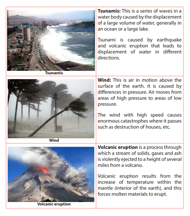
plant. It produces specific symptoms or affects a specific location and is not simply
a direct result of physical injury, e.g. cholera, tuberculosis; AIDS, etc. Poor hygienic
conditions cause diseases like cholera while disease like AIDS are caused by viruscalled Human Immune Virus (HIV)
15.4.2. Non natural catastrophes /calamities
Non-natural catastrophes: These are disasters or emergence situations of which
the principal, direct causes are identifiable human actions or deliberate causes.
i. War: It refers to a state of organized armed conflict between countries
or groups within a country. Wars are caused by misunderstanding and
mistrust between and among the parties involved. These could be flowing
from social, economic, ideological, political or cultural matters.
ii. Famine: It is a widespread scarcity of food that may apply to any faunal
species, which phenomenon is accompanied by regional malnutrition,
starvation, epidemic and increased mortality. Famine is caused by droughts,
floods, crop failure due to pests and diseases, rapid increase of population,
bad government policies and political instability.
iii. Fire: A state, process, or instance of combustion in which fuel or other
material is ignited and combined with oxygen, giving off light, heat, and
flame. High atmospheric temperatures and dryness (low humidity) offer
favorable circumstance for a fire to start.
15.4.3. Effects of catastrophes
• Loss of lives and destruction of properties. This happens when buildings fall
down due to earthquakes, floods, Tsunamis, etc.
• Droughts wither the plants and human beings face hunger and starvation.
Animals and birds die; some move away to look for food.
• Population decreases in places where catastrophes occur due to displacement
and death of people.
• Agricultural and industrial productions are negatively affected by pests and
diseases.
• Occurrence of water borne diseases like bilharzia which is caused by water
snails in stagnant water.
• Catastrophes reduce the capacity of the soil to store nutrients and water, thus
make the environment drier.
• Catastrophes can lead to mudslides, soil erosion and landslide in mountainous
areas.
• The government spends a lot of money for restoring the damages. This money
would be used in other developmental projects.
• Degradation of the crust by sediments on the earth surface by stripped soils
or the weathering of rocks at their base where they are in contact with the soil.
Geography Senior Six Student Book 421
15.4.4. Solutions to catastrophes
It is not possible to stop catastrophes. But it is possible to reduce the damage they
cause. People can do the following:
• Building terraces and channels. These help to drain the standing water.
• Droughts can be controlled by afforestation, whereby the levels of air moisture
and precipitation are increased.
• Water reservoirs can also be constructed so that they are used to irrigate the
farms and seedlings.
• Increasing roughness of the soil surface. This entails cropping techniques that
leave large clods on the soil surface or ridges perpendicular to the direction of
the prevailing wind.
• Increasing plant cover. Wind-speed can also be cut by increasing plant density.
Since this is clearly not easy in arid zones, it is particularly important to ensure
sound crop residue management, keeping residues on the ground so as to
increase roughness and protect the soil surface. This is better than ploughing
in, which would only slightly improve soil structure and resistance to wind.
• Practice modern agriculture. These include use of fertilizers, irrigation and
improve food storage facilities.
• Government must provide budget to control catastrophes. It has also to assist
farmers by giving them loans they can use to improve sustainable farming
practices and techniques.
• Prevention of human-caused fires through education and environmental
modification. This includes silviculture activities, people’s participation, and
education enforcement.
• Building houses that can resist to earthquakes.
• For the prevention of the wars, people should discuss any differences that
arise. This is good as it helps to resolve conflicts. Fighting should never be anoption.
Application activity 15.4:
1. Rwanda experiences many catastrophes each year:
a. Describe the common catastrophes in Rwanda.
b. Identify the most affected regions in Rwanda and why.
c. Explain the effects of catastrophes on sustainable development of Rwanda.
2. Identify the types of natural catastrophes common in your area andsuggest ways to mitigate them.
15.5. Tourism15.5.1. Definitions, major tourist areas of the world and factors affecting the development of tourism in the world.
a. Definitions
• Tourism is a travel from one place to another for the purpose of leisure,
research, business, instruction and education.
• Eco-tourism / ecological tourism (green tourism) is the practice of involving
the community living around the tourist attraction sites in the management
and conservation of such sites and the surrounding environment.
• Domestic tourism is whereby the local people visit places of interest within
their country for study, pleasure or recreation.
• International tourism involves organized tours by people from their countries
to other countries.
b. Major tourist areas of the world.
Our world is full of indescribable beauty, both natural and artificial, and it is unclear
whether one life really enough to really experience all that. Most of us will probably
never see anything the world has to offer us, but it’s worth a try. The most areas of
the world are:
• New York as the headquarter of international organization like United Nations,
World Bank, etc.
• Europe as a developed continent with magnificent cities such London, Paris,
Geneva etc.
• Rome, Mecca and Jerusalem as religious centers.
• Historical sites like pyramids of Egypt, Great Wall of China,
• National parks and resorts like Disney World in Florida (USA), Disney in Paris
(Europe), Akagera (Rwanda).
• Beaches in Germany, Seychelles and along coastal lands.
• Mountainous regions like Alps, Himalayas, Kilimanjaro, Rockies, Atlas,
Appalachians, Birunga in Rwanda, etc.
c. Factors affecting development of tourism in the world
• Climate: A favorable climate especially sunny condition attracts people from
cooler northern countries to tropical regions.
• Political stability favors the development of tourism as the average tourist
tends to be easily frightened away from an area with insecurity.
• Capital: Acquired funds help to develop tourist physical and human resources.
• Government policy: Governments set explicit policies of encouraging tourists
to visit their countries by creation of board which plan, market and manage the
tourism industry. This is one of the responsibilities of Rwanda Development
Board (RDB) in Rwanda.
• Accessibility: Improvement of means of transport like roads, airport, favor the
development of tourism.
• Accommodation: Tourists will be influenced to travel to those destinations
where they are assured of decent and affordable accommodation.
• Advertisement: Tourist attractions are made known to the local and
international community using mass media. This information markets wildlife
and other tourist attractions.
• A wide range of tourist attractions in a particular area attracts many touristsboth local and international tourists
Application activity 15.5.1:
1. Explain how physical features contribute to the development of tourism
industry in the world.
2. Mountain gorillas, Rwandan culture, water bodies have contributed
to the recent development of tourism industry in Rwanda. Is it true?Support your answer.
15.5.2. Importance and impact of tourism
Learning activity 15.5.2:
Read the passage below and answer the following questions:
Many tourists come to Rwanda. They bring money to consume while being in
the country. Some appreciate our culture, create friendship with Rwandans
and even when they go back to their countries they tell their friends what
they have seen in Rwanda.
1. Explain different ways tourism industry contributes to the development
of a country.
2. What can be the negative effects of tourism?
a. Importance of tourism in the world
• Tourism is a big foreign exchange earner. Countries benefit from the sale of
licenses to tour operators who are taxed on their profits and entrance fees to
tourism sites. Tax from tourist hotels is a source of revenue to governments.
• It offers employment to thousands of people in both public and private sectors.
• It enhances the development of industries particularly the accommodation
and service industries.
• It enhances the development and the general improvement of infrastructure.
Roads leading to tourist attractions are well maintained. Airstrips to such
places have been constructed.
• Improvement in the standards of living where people earn income because
tourists buy basic needs and luxuries.
• It enhances the development of international cooperation between countries.
• A profitable tourism tends to lead to renewed interest in the protection of
wildlife and natural resources so that continued existence lead to sustainable
development.
• Tourism expands market for locally produced commodities/goods. The
demand for certain items may increase as tourism develops.
b. Impact of tourism on the environment
The following are the major impacts of tourism on the environment:
• The loss of biodiversity:
- Protected animals in the national parks may escape and harm people
and damage their crops and animals.
- Tourists leave fire on the camping and picnic sites which causes damages
to vegetation. This may lead to the loss of valuable forest
• Pressure on the water resources: Water, and especially fresh water, is one of
the most critical natural resources. The tourism industry generally over uses
water resources for hotels, swimming pools, golf courses and personal use
of water by tourists. This can result into water shortages and degradation of
water supplies, as well as generating a greater volume of waste water.
• Land degradation: Important land resources include minerals, fertile
soil, forests, wetland and wildlife. Increased construction of tourism and
recreational facilities have increased the pressure on these resources and
on scenic landscapes. In areas with high concentrations of tourist activities
and appealing natural attractions, waste disposal is a serious problem and
improper disposal can be a major despoiler of the natural environment - rivers,
scenic areas, and roadsides.
• Air and noise pollution: Air and noise pollution from airplanes, cars, and
buses, as well as recreational vehicles such as snowmobiles and jet skis, is an
ever-growing problem of modern life.
• Sewage: Construction of hotels, recreation and other facilities often leads
to increased sewage pollution. Wastewater has polluted seas and lakes
surrounding tourist attractions, damaging the flora and fauna. Sewage runoff
causes serious damage to coral reefs because it stimulates the growth of algae,which cover the filter-feeding corals, hindering their ability to survive.
Application activity 15.5.2:
1. Make a field trip and discuss the impacts of tourism industry on the local
environment.
2. Tourism benefits both the country and the people living around the
visited areas or national parks. Explain this in the context of Rwanda
15.5.3. Problems affecting the tourism in the world and the prospects
Learning activity 15.5.3:
Read the following passage and answer questions that follow:
In developing countries there is high population growth; people have
begun encroaching on areas reserved for national parks and game reserves.
Poaching, deforestation is the order of the day. The need for agricultural
land and settlement has led to reduction of forested areas hence affecting
tourism.1. Identify and explain problems affecting tourism in relation to the
passage.
2. Analyse other human activities that affect tourism industry which are nota. Problems affecting tourism in the world and prospectsmentioned in the passage.
The following are the problems associated with the tourism industry:
• Climate changes: Due to global warming and climate changes, regions which
used to be well-watered and which formed favorable habitats for animals and
plants are becoming drier.
• Decline in wildlife: Incidences of poaching where animals are killed for game,
meat, skins and tusks have led to a decline in the population of wild animals.
• Encroachment on national parks due to population pressure, and this is
threatening the survival of tourism industry.
• Violence or political instability limits the number of tourists coming in the
country.
• Diseases: they destroy plants, kill wild animals and tourists. Diseases like
malaria, sleeping sickness, river blindness etc., scare away tourists.• Less supportive government policy: For example, when the governmentfails to eradicate poaching, encroaching or to set advantages that attract
tourists such as getting entry visas etc.
• Poor management skills: This is in terms of lack of skilled labors in form of
international chefs, leisure and hospitality specialists etc.
• Under developed tourist attraction sites such as historical sites, forest
without accommodation facilities, poor catering services.
• Hostility: Some individuals attack tourists and rob their properties.
b. Solutions to the problems of tourism
• Improvement of tourism facilities and amenities: transport services and
infrastructures, accommodation, security, etc.
• Making the publicity of tourist attractions through television, newspapers,
internet, etc.
• Ensuring anti- poaching and patrol: regulation against hunting and killing
of game animals and bush burning in areas gazette for wildlife have to be
institutionalized.
• Vigorous programs to control the spread of diseases.
• Training tourism workers in customer care management and service delivery.
• Enforcement of laws governing wildlife protection to ensure wildlife
sustainability to attract tourists.
• More game reserves should be gazetted where more wildlife can be protectedand conserved to ensure a variety of wildlife which attracts more tourists.
Application activity 15.5.3:15.5.4. Case studies
Show how shortage of land and poor means of transport are barriers to the
development of tourism industry in developing countries.Suggest measures being taken by Rwanda to develop the tourism industry
Learning activity 15.5.4:
Draw the world map and locate the following countries and their major
tourist attractions.
a. Switzerland.
b. East African Countries.c. USA.
a. Tourism in East African Countries
East African Countries receive tourists originating from worldwide but the majority
are those from countries within Africa, Europe and North America and some others
from Asia.
i. Major tourist attractions in East African Countries• Great abundance of wildlife: animals like elephants, rhinoceros, hippopotamus,ii. Factors influencing tourism industry in East African Countries
lions, leopards, cheetah, zebras, giraffes, buffaloes and antelopes.
• Coastal beaches and fringing coral reefs on the coasts of Dar es Salam and
Mombasa.
• Beautiful scenery (Mount Kenya, Kilimanjaro, volcanoes in Rwanda, block
mountains, Great Rift Valley).
• Pleasant and healthy climate which is moderate.
• National parks: Lake Nakuru, Masai Mara, Tsavu, Akagera National Park, Queen
Elizabeth National Park, Serengeti National Park, Ruvubu National park, etc.
• Cultural diversity, they have unique costumes, traditional dances (Intore in
Rwanda), music and crafts.
• Drainage features like Lake Victoria, Lake Tanganyika, Lake Kivu, Rift valley
Lakes, swimming, sun bathing, all attracts tourists.
• Historical sites e.g. archeological sites like Olduvai gorge, the famous Fort
Jesus, Kasubi tombs for the fallen kings of Buganda, museums, Kings’ palace(Nyanza -Rwanda), etc.
• Availability of a wide range of tourist attractions that are found in various
countries of East Africa.
• Supportive government policy. E.g. tax concessions to tourists, eradication of
poaching, gazetting of national parks.
• Ideal tropical climate: the warm tropical climate is enjoyed by many visitors
from the cold regions such as Europe and North America.
• Relative political stability compare to other African countries guarantees
tourists security and safety.
• Well-developed accommodation facilities in form of hotels and lodges of the
international standards.
• Effective advertisement both at home and abroad to make tourists aware of
the existing attractions and facilities.
• Skilled labors in form of tour guides, game rangers, chefs who can prepare
international dishes and spirits or wines.
• Good hospitality offered by the people in East Africa especially those who
work in the hotels, transport sector, and as tour guides.
• Presence of capital to inject in the tourism industry as provided by local banks
and private sector.
• Good international relationship with other countries such as U.K, Germany,
USA, Canada, has promoted tourism.
b. Tourism in USA: Case study of tourism in the state of Florida
The state of Florida is renowned for its white sandy beaches, camping sites, Fort
Myers Sanibel Island, Orlando resort hotel, Amelia Island, National parks and Zoos
(De Soto, dry Tortugas) and endless summer which attract tourists when it is winter
elsewhere in United States of America and Europe.
Factors that favored tourism in Florida• A reliable transport and communication network of railway, air, water and
road.
• Presence of tour agencies and operators.
• Massive advertisement both in USA and abroad.
• Natural beauty of Florida.
• Several species of beautiful birds such as Bald Eagle, Caracara, Pelicans
Whooping and sand hill cranes and others.
• Availability of capital to invest in infrastructure development.
• The amazing architectural building designs especially along Miami Beach.• Beautiful climate: sunny and cool breezes.• Skilled labor force working in the tourism sector.c. Tourism in Switzerland• Presence of the variety of wildlife ranging from mammals to reptiles.
Tourism is one the leading economic sectors in Switzerland. Switzerland has three
main topographic regions namely Jura mountains in the Northwest, Alps in the
South and Central Swiss plateau or Mittelland. Other tourist attractions are water
bodies (like river Rhine, lake Lucerne, Lake Geneva), conducive climate, wild life with
diversity of plants and animals, culture especially paintings, music, architecture, etc.
Factors that have favored the tourism industry in Switzerland
• Geographical location of Switzerland: it is located in heartland of rich and
developed industrialized region of Europe: France, Germany, Italy.
• It has developed the winter sport of Ski and Alpinism in the summer.
• It is endowed with a variety of relief that provide scenic beauty.
• Drainage system (Rhine river) in Switzerland is another attraction.
• A well-developed hotel, motels and lodging sector has provided adequate
accommodation.
• The Swiss have a well-developed transport and communication networks.
• Swiss hospitality is no doubt a boost to tourism.
• The development of package tours.
• Massive advertisement through magazines, the internet, posters, phone short
massages.
• Abundant and cheap hydro-electric power. This has enabled Switzerland to
electrify her Railway system.
• It has political stability and her policy of neutrality, Switzerland has remained
stable since Napoleonic wars.
• Relatively stable Swiss economy.
• The presence of many international bodies (International Committee for the
Red Cross: ICRC, FIFA, etc.)
• Availability of capital from well-developed banking system.
Application activity 15.5.4:
1. Compare the tourist attractions in Rwanda with those of Switzerland.
2. Analyze the factors influencing tourism industry in East Africa and relatethem with those of Florida in USA.
End unit assessment
1. Account for the persistent famine in many parts of Africa.
2. Discuss the impact of tourism on sustainable development of Africa.
3. Famine is one of the threatening calamities in Africa.
Suggest measures most governments can do to reduce famine in developing countries.
4. The world is currently facing the problem of environmental degradation.
Suggest measures to protect the environment.
REFERENCES
Afedrary, L. (2015). Soil erosion. Retrieved from https://www.monitor,co.ug/
Farming.
Anders, N. (2016, June 25). Amedzofe Village. Retrieved May 6, 2018, from
Amedzofe Village -Touring Travelling Ghana: http://amedzofevillage.com/
en/2016/06/25/akosombo-dam-and-volta-lake/
Aswan. (2000, February 12). wwwbtbegypttamcom/aswan. Retrieved April 23,
2018, from https://sites.google.com/site: https://sites.google.com/site/
wwwbtbegypttamcom/aswan
Authority, T. V. (2009, March 22). Rowellsapushistory. Retrieved May 6, 2018, from
https://rowellsapushistory.wikispaces.com: https://rowellsapushistory.
wikispaces.com/Tennessee+Valley+Authority
Babishangire B.Bernadette B, Bwebare Byamugisha . (1995). Comprehensive and
systematic notes on world problems and development. Kampala: Aristoc
booklex LTD.
Bamusananire E et al. (2013). Geography for Rwanda secondary schools. Advanced
level Senior Five. Fountain.
Bishop, V. a. (2001). Water Resources: Processes and Management. London: Collins
Publishers.
Buckle C. (1978). Landforms in Africa. London: Longman.
Bunnet R.B. (1973). General Geography in diagrams. Pearson Education South Asie
Pte Ltd.
Bunnet R.B. (1984). Physical geography in diagrams for Africa. Longman.
Bunnet R.B. (2010). Physical geography in diagrams for Africa. Kigali: Longman.
Bunnet, R. B. (2008). General Geography in Diagrams Longman. London: PEARSON
Longman.
BYAMUGISHA, B. (2010). Focus on world Geography . Kampala: KABS publishers
LTD.
Byamugisha, B. (2010). Physical Geography: A Systematic Study in Geomorphology
and Climatology for advanced level students. Kampala: Kabs Publishers Ltd.
Byamugisha, B. (2010). Sysematic Study in Geomorphology and Climatology for
Advanced level Students. Kampala.
Byamugisha, B. B. (1995). Comprehensive and systematic notes on world problems
and development with answered questions. Kampala: Aristoc Booklex Ltd.
Byizigiro, V., & Biryabarema. (2009). Soil erosion. Kigali: Rwanda Natural Science.
Cheng Leong, G. a. (1999). Human and Economic Geography. 2nd Ed. Great
Clarendon Street: Oxford University Press.
Christopherson, R. W. (2012). An Introduction to Phyisical Geography: Geosystems.
New Jersey: Pearson Prentice Hall.
Collins Buckle. (2007). Landforms and landscapes in Africa: AN introduction to
Geomorphology. Ednburgh: Pearson Education Limited.
Conrad K. (2015). IGCSE Geography support. Retrieved from https//
kisigcsegeography.wordpress.com.
CoolBen. (1996, January 1). https://adst.org/. Retrieved May 6, 2018, from ADST:
https://adst.org/2016/06/dont-give-dam-feud-financing-aswan-high-dam/
ESchooltoday. (2008 - 2017). eSchooltoday. Retrieved from https://www.
eschooltoday.com.
Gabler, R. P. (2009). Physical Geography. Belmont: Brooks/Cole, Cengage Learning.
GILLIAN C. MORGAN, GOH CHENG LEONG. (1982). Human and Economic Geography.
New York: Oxford university press.
Glencoe. (1999). Earth Science: Teacher Wraparound Edition. Westerville: McGrawHill.
Henrie M.K. (2009). Principles of Physical Geography. Kampala: Compsolutions.
Herbert H. G. (1983). World Geography Revised. United States of America: Follett
Social Studies, Allyn and Bacon,Inc.
Historica, N. (2013). Exploring the intersection of science. Retrieved from The
Natural Historian.com.
Islam, T. (2008, November 12). Tripod. Retrieved February 18, 2018, from Continental
Drift: http://saif181.tripod.com/index.html
John Whitton. (1984). Dictionary of Physical geography. New York: Nwe York .
Kallie, S. (2017 , July 16). The Yellow River. Retrieved May 6, 2018, from www.thoughtco:
https://www.thoughtco.com/yellow-river-in-chinas-history-195222
Karuggah R. & Kibuuka P. (2009). Certificate Geography Form 1.
Nairobi, Kenya: Oxford University Press.
Kichodo, H. M. (2009). Principles of Physical Geography:
Advanced Level Geography. Kampala: HMK. KICHODO, H. M. (2011).
world problems and development. Kampala: Camp solutions. Kichodo, H. M. (2011).
World Problems and Development: Advanced Level Geography.
Kampala: HMK. Lorenz, A. (2012, June 2).
Old and New China Meet Along the Yellow River.
Retrieved May 6, 2018, from https://abcnews.go.com/International:
https://abcnews. go.com/International/china-meet-yellow-river/story?
id=16468814 Marshal, T. (2001, January 15). Wikipedia org.
Retrieved March 14, 2018, from Wikipedia Web Site: https://en.wikipedia.org/wiki/Lists_of_countries_by_mineral_production Mcmaster,
D. N. (2000). Mapreading for East Africa Longman.
Edinburgh: Longman. Miles. (2001, January 15).
Wikipedia. Retrieved February 11, 2018, from
Wikipedia: https://encrypted-tbn0.gstatic.com/images?q=tbn:ANd9GcSZAVk6yonsdmFUdAUfWw9O86j6_3LP27u3mv7e2k3G7BFwJcA7 Minns,
W.J. (1984). A geography of Africa. Macmillan. MonkHouse, F.J. (2008).
Principles of physical Geography. London:
Hodder Education. Mwise Thomas, et al. (2015). Geography syllabus advanced level s4-6.
Kigali: Rwanda education board. NAPA-RWANDA. (2006).
National adaption programs of action to climate change.
Kigali: Ministry of lands, environment, forestry, water and mines.
Ndehedehe, C. E. (2017). Analysis of hydrological variability over
the Volta river basin using in-situ data and satellite observations.
Journal of Hydrology: Regional Studies, 88-110. Nzabona A.C.N (1998).
Physical Geography for Advanced level: Questions and essay guides.
Published in Kampala (U). Safari Sibo et al. (2013).
MK SENIOR 5 SECONDARY GEOGRAPHY STUDENTS BOOKS.
Kampala: MK. S-Cool.CO.UK. (n.d.). Elluviation and illuviation processes of weathering.
Retrieved from https://www.google.rw/search. SENTAMU, S. A. (2011).
Statistics and geography of the world. Kampala. Strahler, A. (2011).
Introducing Physical Geography, 5th Ed. Boston: John Willey and &
Sons Inc. Strahler, A. a. (2008). Visualizing Physical Geography. Hoboken:
John Wiley & Sons. Tjeerd, H. M., & van Andel and Brendan,
J. (2018, January 12). ENCYCLOPÆDIA BRITANNICA.
Retrieved February 11, 2018, from ENCYCLOPÆDIA BRITANNICA:
https://www.britannica.com/science/plate-tectonics.
Toor, A. (2013, April 3). The Verge. Retrieved May 6, 2018, from theverge.com: https://www.theverge.com/2013/4/3/4175514/china-rivers-disappear
-fromthe-map-water-supply-crisis. UK ESSAYS. (March, 2015).
The importance of the Nile River. Environmental science essay.
UNICEF. (2008). Rwanda earthquakes: Unicef responds to
immediate needs of children and women affected by earthquakes.
Kigali: Unicef.Water Technology. (1983, January 1).
Retrieved May 6, 2018, from www.water-technology.
net: https://www.water-technology.net/projects/aswan-high-damnile-sudan-egypt/
Water-resources. (2010, Jan 1). https://www.nextgurukul.in/wiki/. Retrieved April
23, 2018, from Multi-purpose-river-projects: https://www.nextgurukul.in/
wiki/concept/cbse/class-10/geography/water-resources.
Waugh, D. (2009). Geography: An Integrated Approach. London: Nelson Thornes.
Whitton, J. B. (1984). Dictionary of physical geography. New York: PEGUIN BOOKS.
Whittow J. (1984). Dictionary of physical geography. Penguin books.
Wu, A. ( 2015, September 21). The Geography of the Yellow River. Retrieved May
6, 2018, from chinahighlights: https://www.chinahighlights.com/yellowriver/
geography.htm
WEBSITES
http:// the freedictionary.com/
http://agritech.tnau.ac.in/agricultural_engineering/greenhouse.
http://umunyamakuru.com/fr/rwanda-vers-une-solution-de-lenergie-electrique/
http://www.fonerwa.org/portfolio/akanyaru-watershed-protection-project. Retrieved on 17.3.2017
http://www.globalnewlightofmyanmar.com/the-greenhouse-effect-and-the-global-warming/
http://www.midimar.gov.rw/index.php?id=2 Retrieved on 19.3.2018
http://www.monitor.co.ug/Magazines/Farming/How-air-pollution-affects-agriculture
http://www.thenewstrack.com/top-10-main-causes-of-global-warming-2014/
https://courses.lumenlearning.com/earthscience/chapter/wave-coastal-features/
https://en.wikipedia.org/wiki/listontap.com/top-10-effects-global-warming-2
https://fr.slideshare.net/slidematters/coral-reef-33469633
https://kids.britannica.com/students/assembly/view/145503
https://news.nationalgeographic.com/2017/11/climate-change-sea-level-waterwill-come-jeff-goodell/
https://oceanservice.noaa.gov/facts/coral_bleach.htmlstationary.
https://seriouslysilly.wikispaces.com/file/view/8.5+The+Greenhouse+Effect.pdf.
Retrieved on 18.3.2018
https://thenaturalhistorian.com/2013. Naturalis Historica: Exploring the intersection of
science
https://www.clearias.com/erosion-deposition-wind-waves/
https://www.economist.com/sites/default/files/imagecache/640-width/images/
print-edition/20171202_STP002_0.jpg
https://www.flickr.com/photos/oxfameastafrica/5933226731https://www.google.rw/imgres?imgurl
Glossary
Active continental margins: Continental margins that coincide with tectonically
active plate. Asthenosphere: The plastic like, soft layer below the lithosphere in
earth’s mantle, beneath the rigid lithosphere.
Adaptation measures for climate change: Measures and strategies taken to adapt
to climate change and its variability.
Aerosols: Suspended Particulate Matter (SPM) in the atmosphere including solid
particles of varying sizes and liquid droplets are collectively called aerosols which
include: ploughed soil cover, deserts, rocks, salt particles from seas and oceans;
meteoric particles, organic matter: bacteria, seeds, spores and pollen.
Agro-based industries: Are industries which process/ use agriculture products as
raw materials.
Agro-forestry: It is a combination of agriculture and forestry for more diverse,
profitable, productive and sustainable land use.
Andesite: Extrusive igneous rock of diorite composition, dominated by plagioclase
feldspar; the extrusive equivalent of diorite.
Antecedent drainage: A part of a river slope and the surrounding area uplifts but
the river maintains its original slope.
Basalt: Extrusive igneous rock of gabbro composition; occurs as lava.
Bleach coral reefs: These are white coral reefs after expelling the algae (zooxanthellae)
CFCs: Chlorofluorocarbons; are fully halogenated paraffin hydrocarbons
that contain only carbon, chlorine, and fluorine, produced as volatile derivative of methane,
ethane, and propane.
Clay minerals: class of minerals produced by alteration of silicate minerals, having
plastic properties when moist.
Clay: sediment particles smaller than 0.004 mm in diameter.
Climate change mitigation: Involves reductions in human (anthropogenic)
emissions of greenhouse gases.
Climate variability: It is variations of atmospheric conditions at a specific location
or globally in short term.
Climate: The average weather conditions at specific place over a lengthy period of
time (> thirty years).
Coal: Rock consisting of hydrocarbon compounds, formed of compacted, lithified,
and altered accumulations of plant remains (peat).
Collision: Process where two continental crust collide and, as neither can sink, are
forced up into fold mountains.
Compression (tectonic): Squeezing together, as horizontal compression of crustal
layers by tectonic processes.
Concessions: A thing that is granted, especially in response to demands after a
compromise
Conglomerate: A sedimentary rock composed of pebbles in a matrix of finer rock
particles.
Continental crust: Crust of the continents, of felsic composition in the upper part;
thicker and less dense than oceanic crust.
Continental drift: Hypothesis proposed by Alfred Wegener, which states that continents
have moved horizontally around the globe, over time, to reach their current
location.
Continental lithosphere: Lithosphere bearing continental crust of felsic igneous
rock.
Continental margins tectonic: Marginal belt of continental crust and lithosphere
that is in contact with oceanic crust and lithosphere, with or without an active plate
boundary being present at the contact.
Continental margins: A zone which combines both the continental shelf and the
continental slope and is distinct from the deep-sea floor.
Control Gate: A facility used to control over the water travelling in penstock.
Convection current: The driving forces of plate tectonics in which hot, plastic-like
material from the mantle rises to the lithosphere, moves horizontally, cools, and
sinks back to the mantle.
Convergent boundary: In plate tectonics, the boundary between two plates that
are converging, or moving toward each other.
Coral reef: Skeletons of very small sea creatures.
Coral: A marine polyp capable of secreting calcium carbonate to build an external
skeleton.
Coriolis force: Deflecting motion caused by the rotation of the earth which makes
a body or current moving across its surface to be deflected to the right in the north
hemisphere, and to the left in the south hemisphere.
Crane: A type of machine, generally equipped with a hoist rope, wire ropes or chains,
and sheaves that is used both to lift and lower the gates which regulate intake gates
or water flow from reservoir through the tunnel of a dam.
Crust: Outermost solid layer of the earth, composed largely of silicate materials
Dam: a barrier constructed across a river to hold back water and raise its level,
forming a reservoir used to generate electricity or for domestic, irrigation or industrial
water supply. Some dams are built also to preventing the flow of water or loose solid
materials (such as soil or snow).
Deposition: The laying down of material that has accumulated after having been
eroded and transported.
Desertification: Land degradation in which a relatively dry land region becomes
increasingly arid, typically losing its water bodies as well as vegetation and wildlife.
Development: The process in which some economic sectors or activities (e.g. agri-
culture, industry, technology, etc.) grow or change and become more advanced
Diorite: Intrusive igneous rock consisting dominantly of plagioclase feldspar and
pyroxene; a felsic igneous rock.
Divergent boundary: In plate tectonics, the boundary between two plates that are
diverging, or moving away from each other.
Dolomite: Carbonate mineral or sedimentary rock having the composition calcium
magnesium carbonate.
Drainage pattern: A plan made by a river and its tributaries along the landform
Dredging: Clear the bed of a harbour, river, or other area of water by scooping out
mud, weeds, and rubbish with a dredge”the dredging and deepening of the canal”.
Dry farming: This is also called Dry land Farming. It is the cultivation of crops without
irrigation in regions of limited moisture, typically less than 20 inches (50 centimetres)
of precipitation annually.
Earthquake: A trembling or shaking of the ground produced by the passage of seismic waves.
Ecosystem: Total living things in an area including ways they interact each other in
the environment
Effluents: Liquid waste or sewage discharged into a river or the sea from industries.
Embezzlement: Theft or misappropriation of funds placed in one’s trust or belonging to one’s employer.
Encroach: To take over someone’s space or to advance gradually on someone’s
territory beyond limits.
Eustasy: any uniformly global change of sea level that may reflect a change in the
quantity of water in the ocean, or a change in the shape and capacity of the ocean
basins
Extinction: the state or process of being or becoming extinct /disappearance,
vanishing.
Extrusive igneous rock: Rock produced by the solidification of lava or ejected
fragments of igneous rock (tephra).
FAO: The Food and Agriculture Organization of the United Nations is a specialized
agency of the United Nations that leads international efforts to defeat hunger.
Feldspar: Group of silicate minerals consisting of silicate of aluminum and one or
more of the metals potassium sodium, or calcium (See also plagioclase feldspar, potash feldspar)
Felsic igneous rock: Igneous rock dominantly composed of felsic minerals.
Felsic minerals (felsic mineral group): Quartz and feldspars treated as a mineral
group of light color and relatively low density. (See also mafic minerals.)
Flood control: Methods are used to reduce or prevent the detrimental effects of
flood waters.
Gem: Also called Game stone is a valuable mineral highly prized because it is rare
and beautiful.
Gentle slopes: These are areas located in rolling countryside where
slope is between 5 and 15% and the pattern of rainfall distribution regularly results in erosion
events. They are very common in Mediterranean countries
Glacier: It is a large mass of ice in motion.
Gondwanaland: A supercontinent of the Permian period including much
of the regions that are now South America, Africa, Antarctica, Australia,
New Zealand, Madagascar, and peninsular India.
Granite: Intrusive igneous rock consisting largely of quartz, potash feldspar and
plagioclase feldspar with minor amounts of biotite and hornblende; a felsic igneous
rock
Gravity: The force by which objects are attracted to one another because of their
mass on the earth surface.
Greenhouse effect: Is process in which atmosphere of earth trap some of
heat coming from sun, making Earth warm than usual.
Holomorphic soils: These are intrazonal soils which have developed in areas where
salts have accumulated at or near the surface.
Hurricane: A type of tropical cyclone with sustained winds that exceed 74 mph and
accompanied by rain, thunder and lightning
Hydro-electric power plant (hydro-electric power station): Is a power generating
station which utilizes the potential energy of water at a high level for the generation
of electrical energy by converting potential energy to kinetic energy.
Hydroelectricity (Hydro-electric power): Is electricity made from the energy of
free-falling water. The term refers to the generation and distribution of electricity
derived from the energy of falling water or any other hydraulic source.
Hydromorphic soils: These are intrazonal soils developed in presence of excess water.
Ice cap: An area of permanent ice.
Intrusive igneous rock: Igneous rock body produced by solidification of magma
beneath the surface, surrounded by preexisting rock.
Irrigation is the application of controlled amounts of water to plants at needed
intervals. Irrigation helps grow agricultural crops, maintain landscapes,
and revegetate disturbed soils in dry areas and during periods of less than average rainfall.
Irrigation also has other uses including crop production, including forest protection
and preventing soil consolidation.
Isostasy: Principle describing the flotation of the lithosphere, which is less dense, on
the plastic asthenosphere which is denser / the state of balance, or equilibrium, which
sections of the earth’s lithosphere (whether continental or oceanic) are thought
ultimately to achieve when the vertical forces upon them remain unchanged
Isostatic compensation: Crustal rise or sinking in response to unloading by denu-
dation or loading by sediment deposition, following the principle of isostasy.
Isostatic rebound: Local crustal rise after the melting of ice sheets, following the
principle of Isostasy.
Latitude: A distance on the earth surface measured in degrees north and south of
the equator
Laurasia: A supercontinent of the Permian period, including much of the region
that is now North America and western Eurasia.
Lava: Magma emerging on the Earth’s solid surface, exposed to air or water.
Levee: Also called embankment or flood bank or stop bank is an elongated naturally
occurring ridge. It is usually earthen and often parallel to the course of a river in its
floodplain or along low-lying coastlines.
Lithosphere: The rigid, outermost rock layer of the earth, about 100 km
thick, composed of the crust and part of the mantle, lying above the asthenosphere.
Mafic igneous rock: Igneous rock dominantly composed of mafic minerals.
Mafic minerals (mafic mineral group): Minerals, largely silicate minerals, rich in
magnesium and iron, dark in color, and of relatively greater density.
Magnetometer: A sensitive instrument that records magnetic data and is used to
study earth’s magnetic field.
Marble: Variety of metamorphic rock derived from limestone or dolomite
by recrystallization under pressure.
Meanders: Curved bends of a river in either middle or lower stage
Metamorphic rock: Rock altered in physical structure and/or chemical (mineral)
composition by action of heat, pressure, shearing stress, or infusion of elements, all
taking place at substantial depth beneath the surface.
Mid-oceanic ridge: One of three major divisions of the ocean basins,
being the central belt of submarine mountain topography with a characteristic axial rift.
Mineral: Is a naturally occurring chemical compound, usually of crystalline form
and abiogenic in origin (not produced by life processes). A mineral has one specific
chemical composition, whereas a rock can be an aggregate of different minerals or
mineraloids. The study of minerals is called mineralogy
Multipurpose project: A project designed to serve more than one purpose.
For example, multipurpose river project that provides water for irrigation, recreation, fish
and wildlife, and, at the same time, controls flood or generates electric power.
NGOs: They are usually non-profit and sometimes international organizations
independent of governments and international governmental organizations and are
active in humanitarian, educational, health care, public policy, social, human rights,
environmental, and other areas to effect changes according to their objectives.
Oasis: A moist fertile place in the desert usually surrounding a well or spring
Oceanic crust: Crust of basaltic composition beneath the ocean floors, capping oceanic lithosphere.
Oceanic lithosphere: Lithosphere bearing oceanic crust.
Oceanic trench: Narrow, deep depression in the seafloor representing the line of
sub-duction of an oceanic lithospheric.
Ore: A mineral containing a useful substance, such as metal, that can be mined at a
profit.
Ox-bow Lake: A horse shoe shaped lake form from a meander that is cut off and
abandoned by the main river.
Pangaea (pan JEE uh): The name Alfred Wegener gave to the single large landmass,
made up of all continents, that he believed existed before it broke apart to form the
present continents.
Parent rock: It is the material (rock) from which soil is formed.
Passive continental margin: Continental margin lacking active plate boundaries at
the contact of continental crust with oceanic crust.
Penstocks: Are generally made of reinforced concrete or steel to transport water
from reservoir to turbine with less friction losses.
Peridotite: Igneous rock consisting largely of olivine and pyroxene; an ultramafic
igneous rock occurring as a pluton, also thought to compose much of the upper
mantle.
Petrology is the branch of geology that studies rocks and the conditions under
which they form. Petrology has three subdivisions: igneous, metamorphic,
and sedimentary petrology
Plate tectonics: Theory that earth’s crust and upper mantle (lithosphere) are broken
into sections, called plates that slowly move around on the mantle.
Poaching: The illegal practice of hunting or stealing wild game.
Power House: House where generated power from alternator will be stepped
up and supplied to transmission lines
Power is the capacity of energy, which is being used, while energy is ‘joules’, power
is ‘joules per second’. Well, in another words Power is ‘watt’ and Energy is ‘watt-hour’.
Another difference is that energy can be stored whereas power cannot be stored.
Prevailing wind: The direction of wind most frequently observed during a given
period.
Pyroclastic materials: The fragmental rock products ejected by a volcanic
explosion having been broken by fire.
Quartzite: Metamorphic rock consisting largely of the mineral quartz.
Reservoir: Usually means an artificial lake, storage pond or impoundment created
using a dam or lock to store water. Reservoirs can be created by controlling a stream
that drains an existing body of water.
Rhyolite: Extrusive igneous rock of granite composition; it occurs as lava or tephra.
Ridge: An elongated area of relatively high altitude bordered by an increasingly low
altitude side.
River capture: The diversion of waters of a weaker river into the system of a stronger
River profile: A section of a river from its source to its mouth.
River rejuvenation: The renewed erosive activity of a river.
River terraces: A portion of the former flood plain of a river now, abandoned and
left at a higher level as the stream down cuts its sides
River: A mass of flowing water from a known source to a known destination
Rock or stone is a natural substance, a solid aggregate of one or more minerals or
mineraloids.
Run off: The proportion of rain water that reaches streams either by flowing over
ground.
Sandstone: Sedimentary rock consisting largely of mineral particles of sand size.
Schist: Foliated metamorphic rock in which mica flakes are typically found oriented
parallel with foliation surfaces.
Sea: A body of salt water smaller than an ocean and generally in proximity to continent.
Seafloor spreading: The theory that magma from earth’s mantle rises
to the surface at mid-ocean ridges and cools to form new seafloor, which new magma pushes
away from the ridge.
Sediment: Finely divided mineral matter and organic matter derived directly
or indirectly from pre-existing rock and from life processes.)
Sedimentary rock: Rock formed from accumulation of sediment.
Shale: Fissile, sedimentary rock of mud or clay composition, showing lamination.
Siltation: It is the pollution of water suspended sediments dominated by clay and
silt. Siltation is most often caused by soil erosion.
Silviculture: A branch of forestry dealing with the development and care of
forests
Slate: Compact, fine-grained variety of metamorphic rock, derived from shale,
showing well-developed cleavage.
Slope: It is an inclined surface.
Snow: precipitation in form of white ice crystals
Soil: It is the thin layer of unconsolidated material covering the surface of the earth
that is able to support plant life.
Soil: Top layer covering the earth surface.
Spreading plate boundary: Lithospheric plate boundary along which two plates of
oceanic lithosphere are undergoing separation, while at the same time,
new lithosphere is being formed by accretion.
Starvation: A prolonged lack of food, often causing death.
Steric effect: When some regions experienced sea level rise while others experienced a fall,
often with rates that are several times to the global mean rate.
Subduction zone: In plate tectonics, the area where an ocean-floor plate collides
with a continental plate and the denser ocean plate sinks under the less dense continental plate.
It is a boundary between two crustal plates along which subduction
is occurring and lithosphere is being consumed.
Subduction: Descent of the down bent edge of a lithospheric plate
into the asthenosphere so as to pass beneath the edge of the adjoining plate.
Superimposed drainage: A drainage pattern which exhibits a discordant drainage:
with the underlying rock structure because it is originally developed on a cover of
rocks that have now disappeared owing to denudation.
Surface run off: The proportion of rain water that reaches streams either by flowing
over ground or by seeping through the soil.
Sustainable development is the organizing principle for responding human needs
and meeting human development goals while at the same time sustaining
the ability of natural systems to provide the natural resources and ecosystem services upon
which the economy and today’s ad future societies depend.
Syzygy: A term given to the situation when the earth, moon and sun
are in conjunction or opposition. i.e. when they are all in a straight line.
Tariffs: A tax or duty to be paid on a particular class of imports or exports.
Tectonic: Pertaining to the internal forces which deform the earth’s crust thereby
affecting the pattern of sedimentation or resultant landforms.
Terra Rosa: It is a reddish clay-loam soil developed under a warm seasonally dry
climate on limestone.
Tethys Sea: inland sea from where the two blocks of landmasses separated
Tidal currents: A horizontal movement of sea water in response to the rise and fall
of the sea or ocean.
Tide: The regular rise and fall of water level in the world’s oceans, resulting from the
gravitational attraction that is exerted upon the Earth by the sun and the moon.
Tornado: A violently rotating column of air that extends from a thunderstorm to the
ground and is often - although not always - visible as a funnel cloud.
Transform fault: In plate tectonics, a boundary between two plates that are sliding
horizontally past one another.
Transform plate boundary: Lithospheric plate boundary along which two plates
are in contact on a transform fault; the relative motion is that of a strike-slip fault.
Tsunami: Train of sea waves set off by an earthquake (or another seafloor disturbance).
Tuffaceous limestone: A sedimentary limestone that contains up to fifty percent
volcanic tuff these are ash and cinders.
Turbines: Water turbines are used to convert the energy of falling water into mechanical energy.
Ultramafic igneous rock: Igneous rock composed almost entirely of mafic minerals,
usually olivine or pyroxene group.
Visibility: The longest distance that prominent object can be seen.
Volcanism: General term for volcano building and related forms of extrusive igneous activity.
Geography Senior Six Student Book 445
Volcano: Conical, circular structure built by accumulation of lava flows and tephra.
Water navigation: Connecting banks of a river or lake,
or connecting ports of a sea, by means of ship.
It will be a part of the navigation as there will be no other
means of travel other than through water Wave:
Is a deformation of water surface in the form of oscillatory movement
which manifests its self by an alternating rise and fall of that surface.
Windblown area: This is an area which experiences a lot of wind as
an agent of erosion. Yazoo or deferred tributary: A tributary stream
of the differed junction type or a river prevented from joining the main river by levees.