UNIT 4 EXTERNAL LANDFORM PROCESSES AND RELATED FEATURES
TOPIC 1 Living in Society: Global communication and
Key unit competence: By the end of this unit, I should be able to demonstrate anunderstanding of different features resulting from external processes and their relationships with human activities.
4.1. Weathering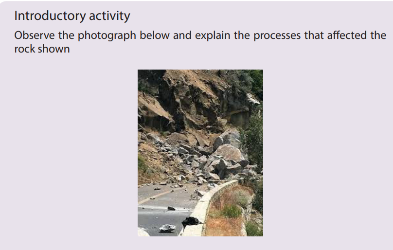
4.1.1. Types and processes of weathering
Learning activity 4.1
a. Making good use of the diagrams below explain the processes involved in
both physical and chemical weathering.
b. Make a research and compare the processes of soil formation and the
processes of weathering
a. Definition of weathering
Weathering refers to the process of disintegration and decomposition of rocks
‘insitu’ into small particles by the action of weather and living organisms.
Agents of weathering: temperature, rainfall (water), wind, animals and plants
(vegetation).
b. Types of weathering
There are three types of weathering namely physical or mechanical weathering,
chemical weathering and biological weathering which cuts across each of the
physical and chemical weathering.
1. Physical weathering
Physical weathering refers to the breakdown or disintegration of rocks, without
any change in the chemical or mineral composition of the rock being weathered.
Rocks disintegrate into smaller particles but maintain their previous chemical
characteristics. Only the physical size and shape change. Physical weathering is
mostly influenced by temperature changes.
Processes of physical weathering include:
i. Thermal expansion or insolation weathering
This process is caused by the changing of temperature ranges which causes
differential heating of minerals forming the rock. When heated dark minerals expand,faster than others resulting in cracking and fragmentation of the rock.

i. Exfoliation
This occurs when there is expansion of rocks during the day and contraction of rocks
during the night due to repeated temperature changes. It is common in arid and
semi-arid regions. This results into rocks of a few centimeters thick to start peelingoff (breaking away) leaving behind exfoliation domes.

ii. Freeze thaw
This process also called frost weathering (or frost shuttering) occurs due to water
that enters into the cracks of the rocks; this water freezes and expands exerting
pressure within cracks. Water from rain or melting snow and ice is trapped in a crack
or joint in the rock.
If the air temperature falls below freezing point, the water freezes and expands. As a
result, the rock becomes weak and breaks. This process is common in cold regions,
especially glacial, periglacial and high mountainous zones. The figure below shows
steps from infiltration of water into the rock to the condensation within rock fissure
which result in the fragmentation.
iii. Pressure release
The process of pressure release known as the unloading or dilatation weathering
occurs when materials on top are removed by erosion. This releases pressure, which
causes the materials below to expand and crack parallel to the surface.
iv. Salt crystallization
The process of salt crystallization weathering illustrated on the figure below occurs
when saline water (or water carrying salts in solution) passes through cracks and
joints in rocks. As it evaporates, the dissolved salts change into salt crystals. These
crystals expand within cracks as they are heated up and apply pressure on the rockleading to its breaking up.
v. Shrinkage weathering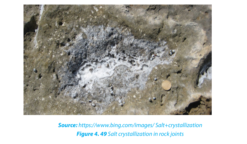
Some clayey rocks expand after absorbing water. For instance, there are some clays
which swell when they absorb water during rainy seasons. This results in increase
in volume. During dry seasons, they massively lose this water through evaporation
and they contract. This process is known as shrinkage. This alternating expansion of
these rocks during the wet season, and contraction during the dry season, creates
stresses and later cracks the rock.
vi. Granular disintegration
This takes place almost in the same way as exfoliation except that in this type, rocks
disintegrate into small particles called granules. It is produced either by differences
in thermal expansion and contraction, or through the frost heaving process
(congeliturbation).
2. Chemical weathering
This is a type of weathering which involves a complete change in the chemical and
mineralogical composition of the rock resulting into the disintegration of rocks. It is
common in areas which experience alternating wet and dry seasons.
The following are the chemical reactions that take place during weathering:
i. Oxidation: oxidation is one of the varieties of chemical weathering in which
oxygen dissolved in water reacts with certain rock minerals, especially iron,to form oxides.

ii. Carbonation occurs on rocks which contain calcium carbonate, such as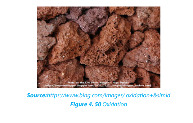
limestone and chalk. This takes place when rain combines with carbon
dioxide or an organic acid to form a weak carbonic acid.
iii. Dissolution: Dissolution is one of the less important forms of chemical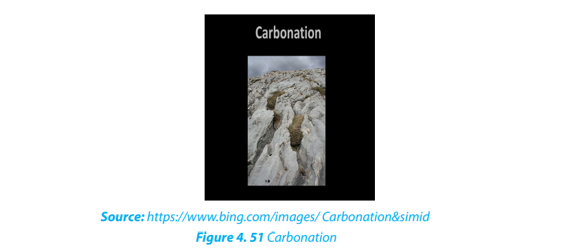
weathering, in which solid rocks are dissolved by water. When water (e.g.
rainwater) mixes with carbon dioxide gas in the air or in air pockets in soil,
a weak acid solution, called carbonic acid, is produced. When carbonic
acid flows through the cracks of some rocks, it chemically reacts withthe rock causing some of it to dissolve.
iv. Hydrolysis: Hydrolysis involves water combining with rock minerals to form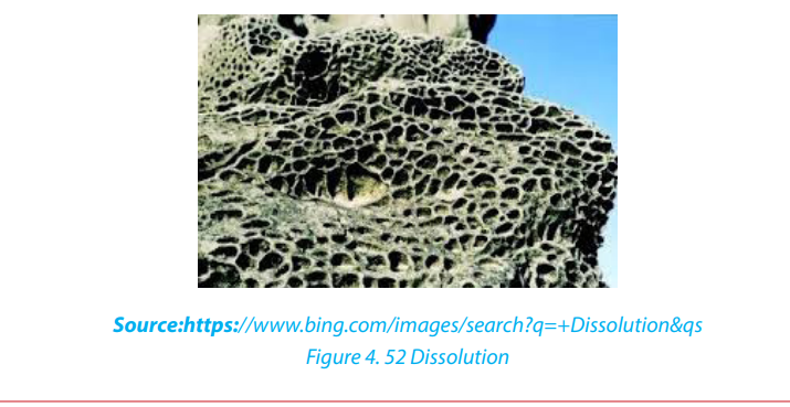
an insoluble precipitate like clay mineral. Compared to hydration-a physical
process in which water is simply absorbed – the hydrolysis process involves
active participation of water in chemical reactions to produce differentminerals.

v. Hydration: Hydration is one of the major processes of chemical weathering,
involving the addition of water to a mineral, causing it to expand and thereby
initiate stress within the rock. For example the conversion of hematite to
limonite. Once minerals have experienced hydration, they become more
susceptible to the effects of chemical weathering, especially those ofcarbonation and oxidation.

vi. Solution: is a process in which the minerals in the rock directly dissolve in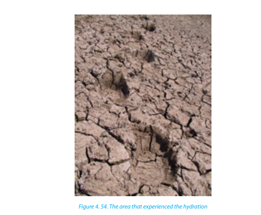
water without their chemical and mineralogical composition being altered.
e.g. olivine, Rock salt (calcium chloride) and calcium bicarbonate are easily
weathered in solution.
e.g. NaCl + H2
O → Na+, Cl- (dissolved ions with water).
vii. Chelation: Chelation is a complex organic process by which metallic cations
are incorporated into hydrocarbon molecules. In fact, the word chelate means
a coordination compound in which a central metallic ion is attached to an
organic molecule at two or more positions. Chelation is a form of chemicalweathering by plants.
3. Biological weathering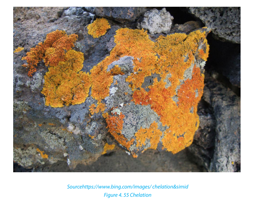
Biological weathering is a process of rock disintegration (decay) due to the influence
of living organisms both growing plants and animals. The diversity of life in soil
includes plants, algae, fungi, earthworms, flatworms, roundworms, insects, spiders
and mites, bacteria, and burrowing animals.
Plants wear away the rocks by their roots which widen the rock joints hence allowing
in other weathering agents like water to disintegrate the rocks. Some plant roots
also have chemicals at the tips of their roots which are acidic and hence cause rock
weathering.
Tree roots find their way into cracks or joints in the rocks. As they grow, they cause
the joints to become bigger. The end result is that the rocks break into smaller piecesat some points.
Burrowing animals like rodents and moles, warthogs (wild pigs) and wild animals in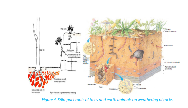
game parks like the chimpanzee, excavate the rocks and as such, they break up therocks hence weathering them. Man also disintegrates rocks through his activities.
Man’s activities such as mining, construction, quarrying, agriculture, etc. result in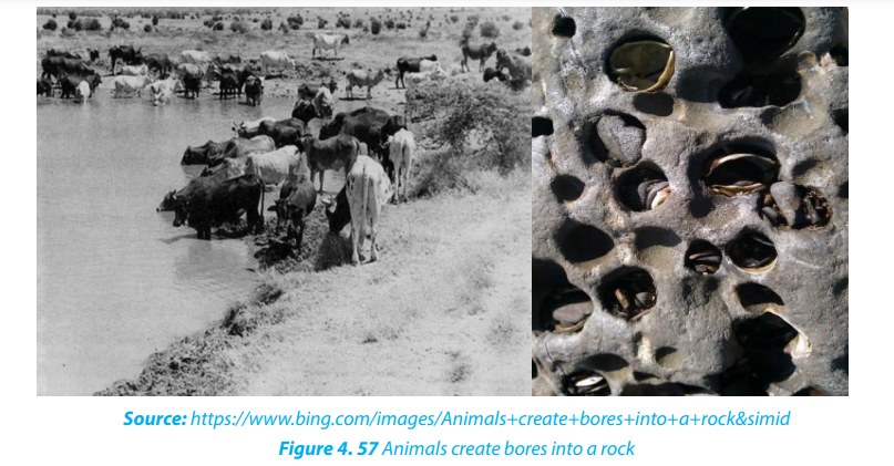
such a fast rate of disintegration of geomaterials (rocks).
Application Activity: 4.1
Use your local environment to identify the evidences of biological weathering.
4.2. Factors influencing weathering and interdependence of physical andchemical weathering
A number of factors are required for weathering to occur in any environment. The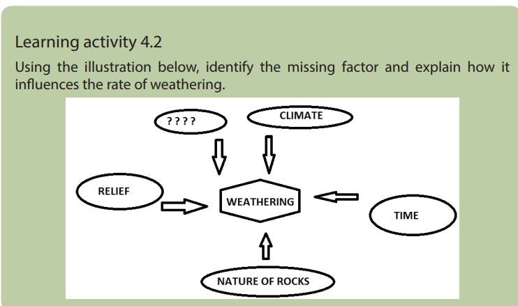
major factors of weathering include:
i. Relief
The term relief refers to the nature of landscape or topography. It influences
significantly the weathering process because it controls the flowing of run-off and
infiltration of water through slope exposition, steepness and length. In mountainous
regions, the windward slopes receive heavy rainfall which may speed up chemical
weathering, whereas the leeward sides receiving little amount of rain becoming
arid. This favors physical weathering to dominate on the lee ward part.
ii. Living organisms
Living organisms include plants and animals. They both contribute to weathering in
a number of ways. Growing roots of trees widen and deepen into the ground and
open up joints. Animals ranging from the big to small, including man affect the rate
of weathering both mechanically and chemically. Animals and micro-organisms mix
soils as they form burrows and pores, allowing moisture and gases to move about
iii. Time
The longer a rock is exposed to agents of weathering, the more weathered it is
likely to be and vice-versa. Young rocks such as solidified volcanic rock after a fresh
volcanic eruption are likely to be less weathered than rocks formed long ago.
iv. Climate
The key components of climate in weathering are moisture and temperature. The
type and amount of precipitation influence soil formation by affecting the movement
of ions and particles through the soil, and aid in the development of different
soil profiles. High temperatures and heavy rainfall increase the rate of chemical
weathering. Arid and semi-arid areas are associated with physical weathering since
there is low rainfall and high temperature. As the rocks expand during a period of
high temperature and contract during a period of low temperature they develop
cracks. In addition, equatorial regions with high rainfall and high temperature
experience fast and deep chemical weathering.
v. Nature of rocks
Nature of the rock determines the rate at which it may break down. Their nature
depends on rock forming minerals. Some minerals are easily soluble. Also
environmental condition such as organic acids and temperature may increase the
rate of weathering of rocks. Soft rocks, for example, break down more easily than
hard rocks. Similarly, jointed rocks (rocks with cracks) break down faster than rock
substances without joints.
vi. The interdependence of physical and chemical weathering
There is interdependence between mechanical and chemical weathering. Chemical
weathering to occur needs first mechanical process which provides fragmented
pieces of rocks. These rock fragments are then attacked by the chemical process of
weathering. Many reasons can be advanced to justify their interdependence:
• The joints and crack found in a rock as a result of physical weathering allow
deeper penetration of water which leads to chemical weathering.
• Some rocks are dissolved in water and weathered away in solution. The
solutions formed may later undergo precipitation leading to the formation of
crystal. These crystals will exert a lot of pressure that will disintegrate the rocks
physically.
• Hydration (chemical process) results in a high rate of absorbing water by
rocks .e.g.: hematite, limonite which makes these rocks to peel off in a physical
process called spheroidal weathering The physical process of frost shattering
opens up cracks in the rock and when these cracks are occupied by water,
chemical weathering process takes place. e.g. carbonation. Roots of plants
which expand within bedding planes of rocks and burrowing animals whichdrill holes in rocks allow water entry into these rocks which accelerates chemical weathering.
Application activity 4.2
Make a field study around your school and explain how relief and nature of the
rock have influenced the rate of weathering
4.3. Weathering in limestone regions
Learning activity 4.3
1. Differentiate the types of weathering.
2. Describe the type of rock associated with limestone regions.
Limestone is a sedimentary rock in which calcite (calcium carbonate: CaCO3) is the
predominant mineral, and with varying minor amounts of other minerals and clay.
Limestone rocks are very sensitive to organic acids derived from the decomposition
of living organisms.
The major landforms associated with weathering in limestone regions are Karsts
landforms that include: caverns, stalagmites, stalactites, pillar, dolines, limestone
pavements (uvalas), poljes.
i. Caverns
Caverns or caves are also one of the important characteristic features of groundwater
in limestone regions. Caverns are formed in several different ways. The rocks in which
most caverns occur are salt, gypsum, dolomite and limestone, with the latter by farthe most important.
ii. Doline
Doline also called Dolina is a round or elliptical hollow on the surface of a limestone
region which is formed when several small hollows merge. The small hollows are
formed when water starts acting on the points of convergence of joints on the
surface.
iii. Uvala
Uvala is a large surface depression (several km in diameter) in limestone terrain (karst
region). It is formed by the coalescence of adjoining dolines and has an irregularfloor which is not as smooth as that of Polje.
iv. Polje
Polje is a large depression in a karst region with steep sides and flat floor. If it is
drained by surface water sources, it is termed as open Polje.
v. Stalactites
Stalactites are protrusions on top of limestone cave formed as results of water
dissolving some rocks which form a solution that leaks from the roof.
vi. Stalagmites
Stalagmites are formed like a columnar concretion ascending from the floor of a cave.
It is formed from the re-precipitation of carbonate in calcite form perpendicularly
beneath a constant source of groundwater that drips off the lower tip of a stalactite
or percolates through the roof of a cave in a karst environment. It may eventually
combine with a stalactite to form a pillar.
vii. Pillars
Pillars are formed within the weathered limestone cave after the joining together of
stalactites from up and stalagmites from down. The two may finally meet forming apillar.
For karst land forms to be formed the following conditions must be in place:
• Precipitation: the major types of precipitation which contribute to
groundwater are rainfall and snowfall.
• Slope: infiltration is greater on flat areas since water is likely to remain in one
place for a long time given that other factors are favorable. On steep slopes, a
ot of water is lost through surface run-off with little infiltrating in the ground.
• Nature of the rock: For groundwater to percolate and accumulate there must
be spaces within the rocks for it to pass through as well as to occupy further
beneath.
• Vegetation cover: the presence of vegetation increases the rate of infiltration.
• Level of saturation of the ground: The rate of water infiltration is high whenthe ground is very dry and the soil is dry; all the air spaces in it are wide open.
Application activity 4.3
In groups make a field trip to any limestone region, observe karst landforms and
present your findings in class.
4.4. Weathering in humid tropical and arid regions and resultant
landforms
Learning activity 4.4
Choose any climatic region (Humid tropical/al/Arid) and identify the type ofweathering which will dominate the area
4.3.1. Humid tropical regions
The tropical climate is characterized by high amount of rainfall (more than 1000mm)
and high temperature of up to and (more than 18° C) respectively. Weathering is
favored in equatorial and tropical regions where the wetness and high temperature
are permanent. During the rainy season, chemical weathering dominates through
the process of hydration, hydrolysis, solution, oxidation, and reduction. In areas
with alternating seasons, chemical weathering is temporary interrupted during
drought periods because of lack of moisture. Physical weathering processes such
as exfoliation, granular disintegration and block disintegration dominate. Therefore,
in tropical (savanna) climate, both physical and chemical weathering processes
dominate in dry and rainy seasons alternatively.
4.3.2. Arid and desert regions and resultant landforms
The features formed in these regions as a result of weathering are both erosional
and depositional.
1. Erosional features
i. Inselbergs
An inselberg (island hill or mountain in German) called Monadnock in the United
States, is an isolated hill, knob, ridge, or small mountain that rises abruptly from a
gently sloping or virtually level surrounding plain. These forms are characterized by
their separation from the surrounding terrain and frequently by their independenceof the regional drainage network.
ii. Bornhardts
These are dome-shaped and steep-sided rocks that rise up to 30 meters. They are
massive rock, commonly granite comprised of bare rock that stretches several
hundred meters. They take many shapes such as oranges. A good example of where
Bornhardts are found is Central Australia.
iii. Tor
A tor is a pile like hill of rocks or rock peak. It is a product of massive weathering andcomes in all manner of shapes.
iv. Pediment
This is a rock that is gently inclined at an angle of 0.5 to 7 degrees. It is concave in
shape and is found at the base of hills where rainfall is heavy and falls over a short
period of time.
v. Deflation basins
Depressions are formed in the deserts due to removal of sand through the process
of deflation and are called deflation basins or blow-outs, or deserts hollows. The
depth of deflation is determined by groundwater table.
vi. Mushroom rock
The rocks having broad upper part and narrow base resembling an umbrella or
mushroom are called mushroom rocks or pedestal rocks. These undercut,mushroom shaped pedestal rocks are formed due to abrasive works of wind.
vii. Demoiselles
Demoiselles represent rock pillars having relatively resistant rocks at the top and
soft rocks below. These features are formed due to differential erosion of hard rocks
(less erosion) and soft rocks (more erosion). The demoiselles are maintained so longas the resistant cap rocks are seated at the top of the pillars.
viii. Zeugen
Rock masses of tabular form resembling a capped inkpot standing on softer rock
pedestal of shale, mudstone is called Zeugen. The bases of such features are broader
than their tops.
ix. Yardangs
These are formed always in the same way as Zeugens except that yardangs only
develop on landscapes which have alternating rock layers with different resistance
to erosion parallel to the direction of prevailing winds. Winds enter and scour up
rock particles from the soft bands, thus digging depressions within the soft bands.The resistant hard bands therefore remain standing high up as raised ridges.
x.Reg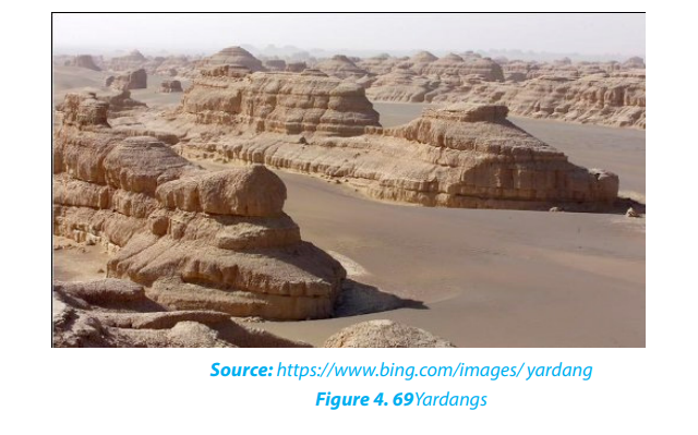
Reg is a desert surface armored with a pebble layer, resulting from long continued
deflation; found in the Sahara desert of North Africa. Often the winds blow off all the
smaller fragments, and leave the bigger size pebbles and gravels over an extensivearea.
xi.Oases
These are depressions that have water in deserts. These are created by strong winds
which remove rock particles from a particular place until a depression is excavated
(created).
2. Depositional features in desert
i. Dunes
Dunes are mounds or ridges of wind-blown sand. They are depositional features of
the sandy deserts and are generally mobile. They vary in size and structure. The main
types of sand dunes are Barchan, Transverse Dunes, and Seifs.
- Barkhans
Also called Barchans, these are typical crescent shaped sand dunes. The windward
slope of barchans is gentle and convex, and the leeward slope is steep and concave.
Barchans move slowly, at a rate of meters per year in the direction of the prevailingwinds.
- Seifs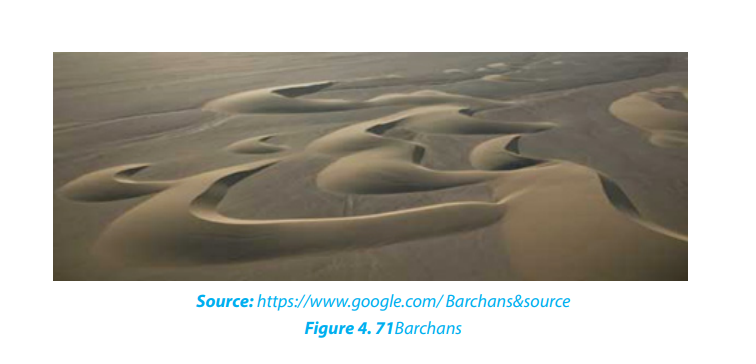
These are long and narrow sand ridge which grow parallel to the direction of theprevailing or dominant wind.
- Transverse dune
Transverse dune is an elongated dune lying at right angles to the prevailing wind
direction. They have a gentle sloping windward side and a steep sloping leeward
side, they are common in areas with enough sand and poor vegetation.
ii. Loess
Loess is a wind-blown deposit of fine silt and dust. It is unstratified, calcareous,
permeable, homogenous and generally yellowish in colour.
Application activity 4.4
Explain the reasons why the erosive power of wind is high in arid regions thanin tropical regions.
4.5. Weathering in the glaciated (cold) regions
Learning activity 4.5Observe the photographs provided below and answer the questions that follow:
4.5.1. Definitions
A glacier is a mass of ice of limited width, which moves outwards from a central
area of ice accumulation. In other words, a glacier is a mass of ice produced by the
accumulation and compression of snow, which moves slowly downhill or sea ward
due to its weight.
Glaciation or glacial activity refers to the work done by glaciers or moving ice. It is
a process of movement of ice usually from mountain tops downhill which leads to
erosional and depositional glacial landforms. Snow/ice is formed when temperature
falls under 0oC.
The permanent ice sheets occur in Greenland, Antarctica, and on high mountain
tops. The level above which there is perpetual snow cover is called a snow line.
In temperate regions, ice accumulation occurs in winter as the temperature falls
under 0oC, and melts later in summer. In tropical regions, snow accumulates on top
of mountains of about 4800m above sea level.
4.5.2. Types of glaciers
The main types of glaciers include the following:
i. Valley glaciers: these are also called alpine or mountain glaciers. They
move down slope and occupy former river valleys under the influence of
gravity and size. e.g. Glaciers on Rwenzori, Kilimanjaro, and Mount Kenya.
ii. Continental glaciers: are alternatively called ice sheets or ice caps. These
cover large areas of the plateau surface. They accumulate from a common
area and spread towards continental margins with massive movement.
e.g.: Glacier found in the polar regions of Greenland, Antarctica, Arctic,
Northern Canada and north Western Europe.
iii. Piedmont glaciers: these are produced when mountain glaciers move
down below the snow line and spread in the low lands of foot hills of
glaciated mountains. They merge to produce large mass of ice.
iv. Cirque glaciers: these are small accumulations of ice which occupy Cirque
basins on the mountain sides.
4.5.3. Types of glacial flow
Glacial movements are categorized into two types: gravity flow and Extrusion flow.
a. Gravity flow
In this process, glaciers move down slope under gravity
and it usually affects lowlying valleys. This kind of gravity flow includes
the following various types:
i. Plastic flowage: ice usually behaves as an elastic brittle solid. When more
ice accumulates, internal stress forces the ice to spread and therefore to
move like a highly viscous liquid.
ii. Regelation: when ice accumulates, pressure is created inside the ice
sheet. This pressure forces some ice to melt and this molten water moves
down-slope. When this water derived from the melting of ice reaches in an
area of low pressure, it freezes again and solidifies to produce ice.
iii. Intergranular translation: this involves the movement of crystals or
granules downslope due to pressure from overlying ice. Melt water
lubricates these ice crystals making it easy for them to slide past each
other.
b. Extrusion flow
As the accumulation of snow on ice caps increases,
there will be an automatic sideways displacement of ice
in all directions following increased accumulation. Hence
ice does not flow necessarily down slope as under gravity flow.
It flows in all directions as a thick porridge spreads
in all directions as more is added. This is how icesheets which cover large areas of plateau surfaces move.
Application activity: 4.5
Using examples distinguish between valley glaciers and continental glaciers.
4.6. Factors influencing the formation and movement of glaciers
Learning activity 4.6
Why is glaciation dominant in high altitude regions?
There are many factors that influence the formation of glaciers in an area. The most
important are briefly described in the following paragraphs:
The effect of altitude: Following the principle of altitude increase and temperature
decrease, glaciers usually form in areas of higher altitudes. e.g. Everest, Kilimanjaro
mountains.
• The factor of latitude: Areas that lie astride the equator within the tropics
have high temperatures that limit ice accumulation. On the other hand areas
far away from the equator have low temperature which favor ice formation.
• Precipitation of snow: Glaciers are formed from the condensation of water
vapor. This results in the formation of ice crystals which fall as snow. The
progressive accumulation and their compaction result in thick and continued
glaciers that cover the surface.
The rate at which glaciers move is different from glacier to glacier and is determined
by a number of factors. The most important are highlighted below:
- Nature of slope: when the slope is steep enough, glacier moves faster than
when slopes are gentle.
- The amount of ice or size of the glacier: when the glacier thickness is big,
there will be more pressure to generate quick motion than when the thickness
is low.
- Temperature: The glaciers are faster in warm climate conditions due to the
presence of enough melt water than in regions of low temperatures. High
temperatures quickly produce melt water, which lubricates the ground for
quick basal slippage and intergranular translation.
- The amount of load: Load is the eroded materials carried by a moving glacier.
The more the load the slower the glacier due to increase in friction and thelesser the load the faster the glacier will be.
Application activity 4.6
Make research on other factors that influence ice accumulation and make a class
presentation.
4.7. The work of glaciers and resultant landforms
Learning activity 4.7
From the experience you acquired in previous lessons, make a difference
between ice and glacier
4.7.1. Processes associated with glacial erosion
Glaciers perform a triple function. These are erosion, transportation, and deposition.
Many processes are associated with glacial erosion but the most important are the
abrasion, plucking and the frost shattering. They are detailed below:
- Abrasion also known as grinding process is the sandpapering effects
of angular material embedded in glacier as it rubs the valley sides and floor. Glacial
abrasion is caused by the rock debris embedded in the glacier.
- Plucking is also referred to as sapping or quarrying. It occurs when the ice at
the base and sides of the glacier freezes onto rock outcrops. The rocks are then
pulled and carried away by the moving ice.
- Frost shattering: this process produces much loose material which may fall
from valley sides onto the edges of the glacier to form lateral moraine.
4.7.2. Landforms produced by glaciers
There are two types of landforms performed by glacial processes:
1. Glacial erosional features
The most common glacial erosional landforms include:
- Cirque: also called corrie is a steep-sided rock basin with a semi-circular shape.
It starts from a small depression which is gradually enlarged. Frost shattering
helps shatter the rocks on the edges of the depression and as they break, the
depression is enlarged.
- Arêtes: an arête is a narrow ridge with steep sides developing between two
corries.
- Pyramidal peak: A pyramidal peak also called horn is a surviving top mountain
mass that is not yet worn down by erosion. It is shaped like a pyramid hence
the term “pyramidal peak”. It is formed at the junction of arêtes.
- Tan: also called tarn, is a cirque lake produced when the ice melts and the melt
water occupy the cirque depression.
- U-Shaped valley or glaciated trough: is formed when a glacier passes
through a pre-existing river valley to a characteristic of U shape profile. The
over deepening and widening of these former river valleys is a product of
abrasive action of ice using large amounts of moraine as its tool.
- Hanging valleys: these are valleys associated with glacial troughs. They are
small valleys whose floors are found at higher level than the floor of the main
valley to which they are tributaries. The floor of the main valley is at a lower
level due to greater erosion than the floor of tributary valleys where there is
less erosive power.

• Ribbon lakes: the floor of a glacial trough is often eroded very unevenly, and
long depressions may be formed at the U-shaped valley floor.
These depressions may become sites of long narrow lakes called Ribbon lakes, for example,
Lake Noir in France.
• Roche montane (roche moutonée): this is a mass of more resistant rock
that projects above the general level of a glaciated valley floor. In most glaciated valleys,
it is possible to find rock surfaces that have been grooved andscratched.
◊ Crag & Tail: This is an elongated rock mass which is formed when a flowing
glacier meets a resistant rock protecting a soft rock on its leeward side. Thesoft rock on the leeward side is called a tail.
2. Glacial depositional features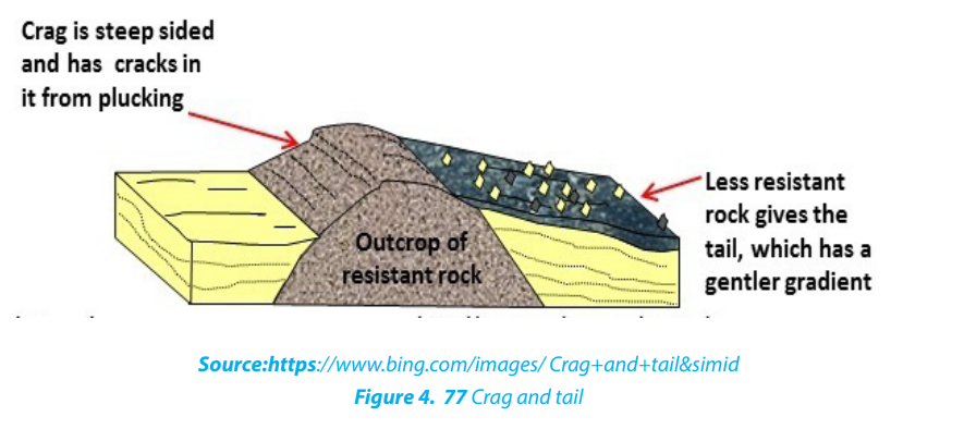
Deposition of debris is among processes performed by glaciers. Debris are
preferably deposited in depression or lowlands. Glacial deposits are generally calleddrifts. They include sands, gravels and rock boulders...
The major glacial depositional features are:
• Moraines
They refer to materials (debris) carried and later deposited by a glacier as it stagnates
or decay. Moraines can be classified into the following types:
- Terminal moraine: these are deposited on the mouth of a glacier.
- Lateral moraine: these are deposited on the sides of a glacial trough and from
elongated ridges on the sides of valley gorges.
- Medial moraine: These are materials that were originally carried by the valley
sides of two small valleys which after emerge into one valley. These materials
found themselves in the Centre of a glacier.
- Ground moraine: This type of moraine covers the entire width of the valley
floor.
• Till plains: these are extensive lowland areas covered by till or a till covered
plain.
• Fluvial glacial deposits: Fluvial glacial deposits are those materials deposited
by melt water from a stagnant glacier. They lead to the formation of the following depositional landforms:
• Outwash plain: is a wide gentle sloping plain which is composed mainly of
sand and gravel which were deposited by unevenly melt water
• Kame: is an irregular mound of sand and gravel deposited by melt water, they
are short lived and can collapse any time.
• Kame Terrace: is a flat topped ridge formed between a valley glacier and the
valley slopes. It is composed of materials deposited by melt water streams
flowing laterally to the glacier.
• Esker: is an elongated, narrow ridge which is made up of sand and gravel.
• Kettle holes: is a depression or hole formed by glacial deposits when a block
of ice detached from the main glacial while the latter is retreating.
• Drumlins: these are low, rounded smooth, elongated mounds or hills of tillrising up to 50m or 1km long. They are products of glacial deposits which flattened the landscape
Application activity 4.7
a. Account for the limited coverage of glaciation in East Africa.
b. Make a research and illustrate the major glacial depositional features.
4.8. Impact of glaciation on the landscape and to human activities
Learning activity 4.8
Using the experience acquired in previous lessons, identify different human
activities carried out in glaciated mountainous regions.
There are many impacts of glaciation on the landscape and human activities. Some
are positive while others are negative. The main impacts are described below:
4.8.1. Positive impacts
- Crop farming: the till and outwash plains contain fertile soils. These are some
of the richest agricultural areas in the world.
- Livestock rearing: the glaciated uplands provide suitable grazing lands since
they form fine benches on which pastures thrive in summer.
- Tourism: glaciated landscape has features such as arêtes, pyramidal peaks and
cirques that attract tourists.
- Natural harbors: fiords provide ideal sites for the development of natural
harbors, for example, the port of Rotterdam in Netherlands, natural habours in
Norway and Sweden.
- Fishing grounds: fiord coastlines such as those in Norway provide suitable
fishing grounds since they are deep and well sheltered.
- Provision of water: glacial lakes provide water for domestic and industrial
use.
- Transportation: glacial lakes provide natural waterways, for example, the
Great Lakes of North America.
- Mining: glacial erosion exposes minerals to the surface making their
exploitation easy, for example, gold and copper in the Canadian Shield of
North America.
- Generation of hydro-electric power: waterfalls formed by rivers flowing
through hanging valleys are suitable for the generation of hydro-electricpower, for example, in Switzerland.
4.8.2. Negative impacts
- Production of bare land: in some instances, the land surface has been
scrapped and polished to bare rock. Such regions are of no economic use.
- Discourage settlement: the cold temperatures especially at high altitude
limit settlement and other economic activities. They therefore remain as
wastelands.
- Transport barrier: the rugged landscape produced by glaciers makes it
difficult to establish infrastructure such as roads and railways.
- Hindrance to agriculture: sand and gravels deposited on outwash plainsmake the land unsuitable for agriculture.
Application activity 4.8
Make research using geographical documents and internet on negative effectsof glaciation apart from those mentioned in the content.
4.9. Mass wasting
Learning activity 4.9Observe and explain the phenomena that occurred in the photograph below

Mass wasting or mass movement is defined as the creeping, flowing, sliding or
falling of rocks and weathered materials down slope under gravity. It is different from
erosion in a sense that, in erosion water physically transports away the soil particles,
in mass wasting water does not wash away but assists the rock to slide down under
the influence of gravity. Mass wasting is classified into two major categories: Slow
movement and rapid movement.
4.9.1. Slow movement
Also called creep movements, they are very slow in their motion and they may occur
without being noticed. These slow movements’ include:
• Soil creep: This is the most common and the most widely spread type, because
it is found in both tropical and temperate climate. The movement of materials
is so slow that they may move a few centimeters per day. It can be detected byleaning of trees, electric poles and fencing poles in the direction of the slope.

• Solifluction: This is limited to glaciated mountainous regions and cold climatic
areas where thawing causes the saturated surface layer to creep as a mass overunderlying frozen ground.
• Talus creep: This is a down slope movement of mainly screes that are relatively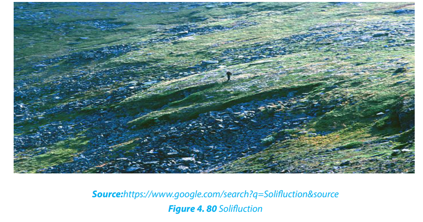
dry. It occurs almost in the same way as soil creep and it also occurs under
tropical and temperate climate.
• Rock glacier creep: This is a slow process of slope failure in which individual
rock boulders with very little soil but with some ice embedded within them
slowly move down slope confined within a channel.
• Rock creep: This is the movement of individual rock boulders slowly down
slope.
4.9.2. Rapid movement
• Earth flows: These are the rapid down ward movements of clayish or silty soils
along a steep slope.
• Mud flows: These are similar to earth flows but they are muddy and occur onslopes that receive heavy rainfall. They are very fast. In Rwanda they are common in the Northern and Western-provinces.
• Debris avalanches: This is the most form of rapid flowage due to the fact that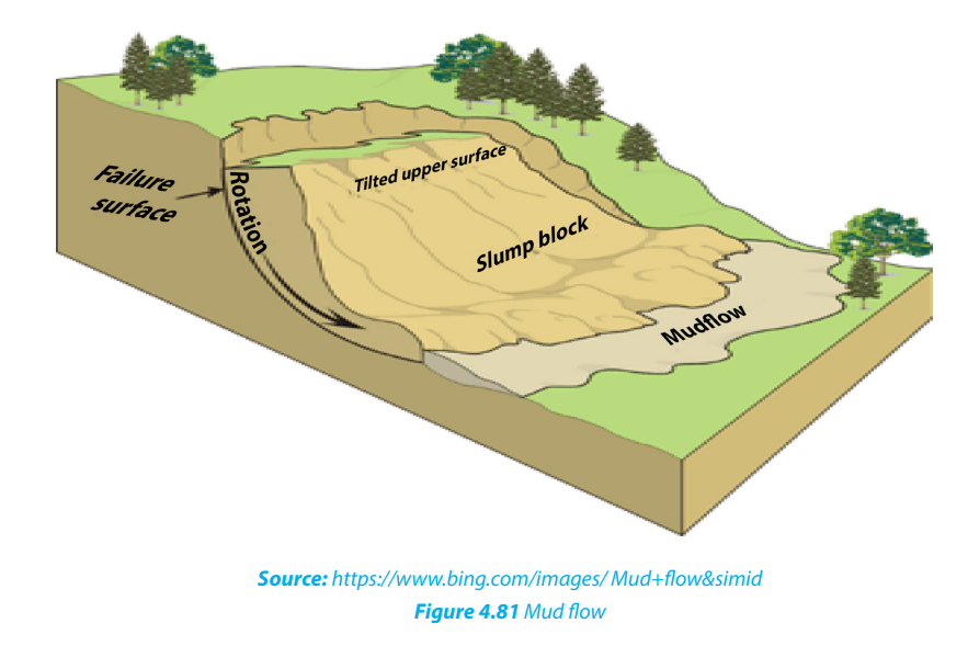
slopes are very steep and there is enough rain to soak slopes. It occurs on very
steep slopes that occur in humid climate.
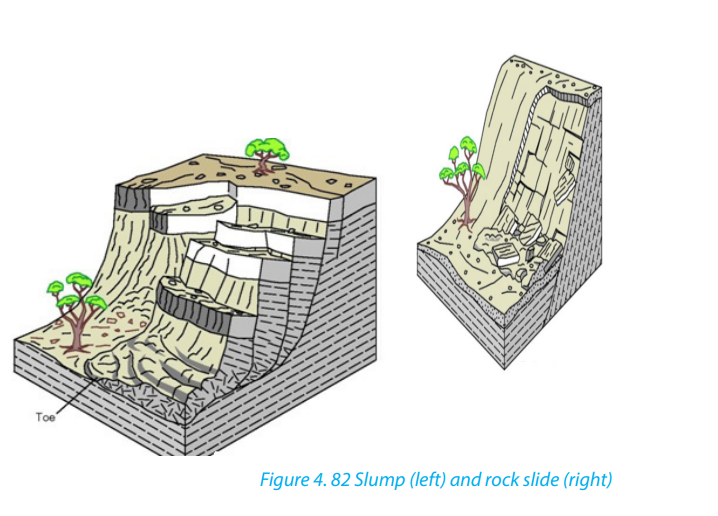
• Slumping: This is the downward slipping of one or several units of rock debris,
usually with a backward rotation with respect to the slope over which movement takes place. Undercutting of slopes by streams and man are the main
causes of slumping. The surface of the slumped mass has a number of step-like
terraces.
• Rock slide: This is the type of sliding in which individual rock masses fall from
vertical cliffs or faces of slopes or jointed cliffs.• Rock fall: Here, individual boulders fall freely from a steep rock face.
Landslides: These are also called landslips. They are down-slope gravitational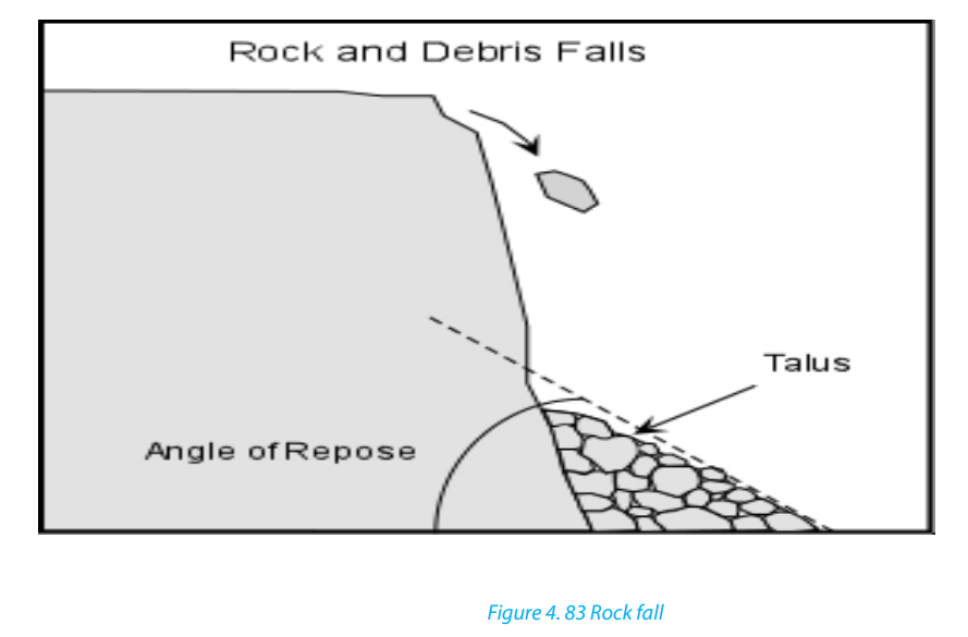
movements of a body of rock or earth as a unit. It may be induced by natural agencies
(like heavy rain, earthquake) or it may be caused by human interference with theslope stability.
Application Activity 4.9
Make research and analyze the types of mass wasting common on hilly areas of
Rwanda.
4.10. Causes, effects and control measures for mass wasting
Activity: 4.10.
Observe the photograph below taken in Gakenke district and describe thephenomenon that took place.
4.10.1. Causes of mass wasting
The following are the major causes of mass wasting:
- The degree of slope: The steeper the slope, the higher are the chances of
material movement. Mass wasting is almost nil in gentle and flat areas.
- The structure and lithology of rocks: Alternating hard and soft rock layers
on a slope can be a cause of slope fall. For example, a layer of clay on top of
limestone layer can easily slide down.
- The degree of lubrication: Most mass wasting processes occur after a heavy
down pour. Water assists to lubricate rock particles and the layers of rock
on top of a slope. Therefore, water provides a medium of sliding because it
reduces internal friction between rock particles and layers.- The amount of load on a slope: Slopes which are light rarely fall compared to
those which are heavy. Therefore, additional load on a slope increase chances
of slope fall.
- Tectonic movements: Earthquake and Volcanic eruptions cause vibrations of
the earth which often trigger off widespread movements of materials such as
landslides
- Climate: The amount and nature of rainfall received in an area determines the
kind of movement that occurs.
- Grazing: The grazing of cattle, movement of elephants and other animals can
cause some tremors on slopes hence making them fall.
- Nature of soil: soils which are infertile and therefore unable to support
vegetation in enough quantities, are more susceptible to mass wasting
compared to soils, which are fertile and therefore able to support dense
vegetation.
- Influence of vegetation: Vegetation help to hold rock materials together thus
reducing their movement on the surface.
- The work of animals: Animals and micro-organisms facilitate deep weathering
which results into the reduced cohesion of the rock particles on slopes. This
therefore leads to easy movement.
- Vulcanicity: Volcanic eruption on the ice capped highlands cause ice to melt
and therefore soak the slopes. This lubrication greatly increases the chances ofslope movement.
4.10.2. Effects of mass wasting
The following are some of the effects of mass wasting:
- Threat to life and property: There are several serious incidents of landslides
and rock slides every year. They cause loss of life and property. In a minor
incident they may block only one line of a road, but in severe cases entire
blocks of buildings collapse.
- Loss of vegetation: Mass wasting and soil erosion result in the loss of surface
topsoil which is essential for vegetation. As a result, more areas become barren.
- Scars and Gullies: In areas where topsoil and vegetation are removed, bare
spots form scars in the landscape. Gullies form on weathered slopes through
rain action and mass wasting in areas with little or no vegetation. Intense gully
cuts up the landscape into large-scale gullies and ridges and destroys the area.
Gullying is common in the bare, granitic areas.
- Pollution of water: large amounts of geologic materials enter streams as
sediments as a result of this landslide and erosion activity, thus reducing the
potability of the water and quality of habitat for fish and wildlife.
- Wildlife destruction: Although most kinds of wildlife are able to retreat fast
enough to avoid direct injury from all but the fastest-moving landslides, often
are subject to habitat damage by landslides.
It is noticed that mass wasting especially landslides, has severe impacts on humans
and environments. For this reason, measures have to be taken for preventing or
mitigating them. Some of the measures are highlighted below:
- Gradients of steeper slopes could be reduced by constructing terraces.
- Retaining walls can be built to stabilize the slope.
- Steep slopes should be inspected regularly, especially during periods of intense
or prolonged rainfall to identify areas prone to mass wasting for preventive
measures.
- More surface drainage channels and ditches can be constructed to reduce
overflowing discharge
- Legislation can restrict development and building in zones prone to mass
wasting.
- Trees can be planted on steeper slopes to stabilize the soil and the slope.
- Appropriate instruments can be installed to monitor slope stability, providing
early warning in areas of concern.
- Mass education of people
Application Activity 4.10
Make a field trip to observe different cases of mass wasting in your area. Analyseits causes and propose the sustainable measures to control it.
4.11. The relationship between weathering landforms and human
activities
Learning activity 4.11
Are landforms resulting from weathering important in your area? Support your
answer.
Weathering affects human activities in various ways as follows:
• Weathering provides a basis for the development of construction industry in
an area. e.g. marrum soil and laterite are good for road construction.
• Weathering can also produce landforms that offer important touristic opportunities.
• Weathering facilitates soil formation, this directly provides a basis for the development of agriculture in the region.
• Weathering affects limestone regions (calcium carbonate) that are important for cement production.
• Building stones in urban areas are subjected to the weathering processes as natural outcrops but with additional influences.
• Weathered shales also produce good brick clays, whereas the weathered basalt produces fertile soils based on montmorillonite.• On weathered rocks, weathering often improves the grade of economic deposits by concentrating desirable elements such as copper around the water table.
Application Activity 4.11
Make research in your area; describe how weathered landforms have benefitedthe people for their sustainable development.
End unit assessment
1. Describe the main causes of mass wasting that usually occur in northwestern part of Rwanda. How does the community work (umuganda)
contribute to the reduction of mass wasting in your area?
2. With reference to East Africa explain the formation of glacial landforms in
mountain areas.
3. How have topography and parent rock influenced the rate of weathering
in your area?
4. Make a field trip in your local environment and explain how the
weathering landforms identified in your area affect positively and
negatively human activities.
5. Referring to above questions suggest ways of sustainable environmentalprotection.