Unit3: THE ORIGIN AND DISTRIBUTION OF THE CONTINENTS
UNIT 3: THE ORIGIN AND DISTRIBUTION OF THE CONTINENTS
1. How many oceans do you find on map a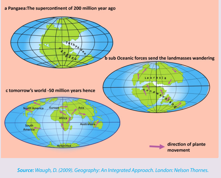
2. How many continents do you see on map b
3. How many continents do you see on map c
4. Explain the processes which led to the separation of the unique initiallandmass into various continents as they appear today.
3.1. Concept and theories of continental drift
Learning activity 3.1
Make research using books and internet to explain briefly the theories related
to the continental drift.
3.1.1. Concept of continental drift
The term continental drift refers to the study of causes and consequences of the
distribution of continents and ocean basins. It is defined as a slow movement of the
Earth’s continents towards and away from each other. The differential movement of
the outer shell resulted into fragmentation by rifting, followed by drifting apart of
individual masses of the broken outer shell.
3.1. 2. Theories of the origin and distribution of the continents and ocean
basins
There are several theories of continental drift that were developed at the beginning
of the 20th century. The following are the four main theories of continental drift:
• Alfred Lothar Wegener’s theory
• Maurice Ewing’s theory
• Harry Hammond Hess’ theory
• Frank Taylor’s theory
a. Alfred Lothar Wegener’s theory
According to Wegener’s theory, there was a breakup of the single super continent
block called Pangaea“pan JEE uh”, which means “all land” into multiple continents,
as they appear today, that moved apart in a process called continental drift. That
movement took place about 200 million years ago. The map provided below fitstogether the continents whose breaking up resulted in today’s continents.
The theory of continental drift traces the origin and distribution of continents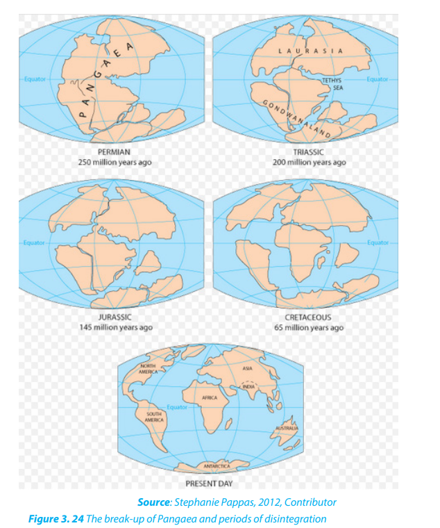
through five major steps:
i. The supercontinent Pangaea was surrounded by an extensive water mass
called the ‘Panthalassa’ (pan means all and Thalassa means oceans) or
the primeval Pacific Ocean. During the Carboniferous period (about 250
million years ago), the South Pole was near Natal (South African coast) and
the North Pole was in the Pacific Ocean.
ii. In about 200 million years, Pangaea broke up to form Laurasia (North
America, Greenland, and all of Eurasia north of Indian subcontinent),
and Gondwanaland (South America, Africa, Madagascar, India, Arabia,
Malaysia, East Indies, Australia, and Antarctica). These two blocks were
separated by a long shallow inland sea called Tethys Sea.
iii. In about 145 million years ago, the drifting of the southern landmasses
continued. India drifted northwards.
iv. In about 65 million years ago, Australia began to separate from Antarctica.
v. The present shapes and relative positions of the continents are the result
of fragmentation of Laurasia and Gondwanaland by rifting and drifting
apart of the broken landmasses following the formations of oceans and
seas (see figure 3.24). South America separated from Africa, North America
separated from Europe, while Antarctica, Australia, India and Madagascar
formed a single unit with South America.
However, Wegener’s theory was initially criticized because he could not explain how
solid continents have changed their positions. His theory has been revived by other
resev. Geodetic evidence Geodetic evidence has revealed that Greenland is drifting
westward at the rate of 20 cm per year. This is one of the scientific evidences arising
from measurement and representation of the earth that confirm the spread of the sea floor.
Application activity 3.2 1.
Describe the rocks at the edge of the continents and show how all continents
formed a unique block.
2. Using some examples, compare the fossils of animal species and
vegetation species found on different continents by showing
how they indicate the continental drift.
archers after discovering new evidences.
f. Maurice Ewing’s theory
Maurice Ewing confirmed the existence of Mid-Atlantic Ridge which is a mountain
range extending the entire length of the ocean bed which is about 1000 km wide
and rises 2500 m in height. Also, Ewing’s studies argue that rocks of this range were
volcanic and recent in origin. Similar ranges were later discovered on other oceans’
floors.
g. Harry Hammond Hess’s Theory: Sea-Floor Spreading
The Seafloor spreading theory suggests that magma from earth’s mantle rises to
the surface at mid-ocean ridges and cools to form new seafloor, which new magma
pushes away from the ridge.
The Sea-Floor Spreading theory was put forward by an American Geologist, Harry
Hess. Sea-floor spreading occurs along mid-ocean-ridge; when the tectonic plates
slowly moves away from each other, hot magma from the mantle comes up to the
surface. As magma cools by the seawater the rock forms a new part of the crust.
The interior of the Earth is in a molten (semi-fluid) state because of great heat
resulting from radioactivity within the asthenosphere. This tremendous heat causes
melting, or near-melting of rocks of the interior of the Earth. The molten rocks tend
to rise from within the mantle in form of convection currents.
Material heated by radioactive elements in the earth’s interior slowly rise in the crust.
This magma reaches the surface along the Mid-oceanic ridges and flows away fromthem, cooling and hardening to form the rigid lithosphere.
New lava emerging from the ridges attaches itself to the near solidified older lava
plates and forces them to move laterally. Hess’s studies demonstrated that after
millions of years the lithospheric plates will have moved thousands of miles by
constant additions of new lava at their rear.
The leading edges were eventually forced to sink down into the lithosphere under
the continental crust block thus forming deep ocean trenches along the edge
of continents. In this “recycling” process, later named “seafloor spreading”, older
sediments and fossils are carried off in the subduction zone, and continents are
moved as new ocean crust spreads away from the ridges.
Hess explained how the once-joined continents had separated into the seven that
exist today. The newest rocks were in the centre of the ocean, and were still being
formed in Iceland, and that the oldest rocks were those nearest to the USA and the
Caribbean. He also suggested that the Atlantic could be widening by up to 5 cm a
year. This process produced by mantle convection currents was named the “Sea floorspreading”.
h. Taylor’s theory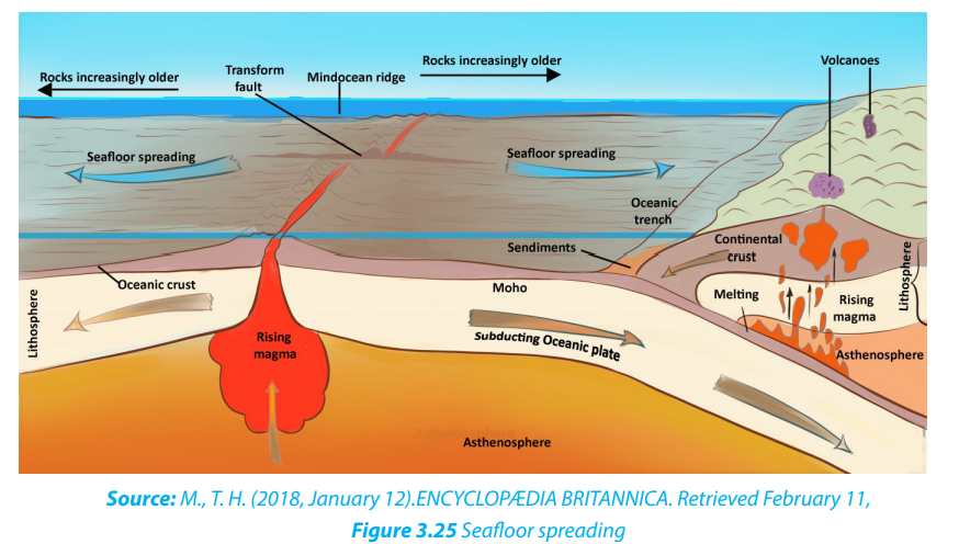
Frank Taylor’s theory states that the original Laurasia was located near the current
North Pole, whereas Gondwanaland was located near the South Pole. Both
landmasses radially moved to the Equator. Their collision would have resulted in the
formation of folded mountains, such as Atlas, Alps mountain ranges and others.
He suggested that Laurasia and Gondwanaland were forced to move from theirformer positions because of the moon’s tidal attraction. According to this theory,
the moon came very close to the earth during the cretaceous period.
This closeness of the moon to the earth exerted powerful tidal attraction, which
pulled the landmasses from their polar position towards the Equator. Where there
was resistance to the outward spread of landmasses, the crust usually would fold,
raising mountain ranges in front, while resulting in stretches (troughs and basins).
The present basins of Southern Atlantic and Indian Oceans were formed in this way.
Taylor’s arguments about continental drift have however been criticized:
• The theory doesn’t clearly demonstrate how the causes of the movement of
continents from their polar positions ought to have been from within the earth
and not outside it.
• The theory was rejected because researchers of his time doubted how the
moon could ever exert enough force to pull the huge landmasses (continents)
as they are known today.
• Finally, Taylor doesn’t explain the formation of earlier fold mountains like the
Caledonian system of Siluro-Devonian times while explaining the possible formation of the fold mountains Atlas and Alps.
3.2. Evidence of continental drift
Many evidences of continental drift exist, but they can be summarized in four major categories:
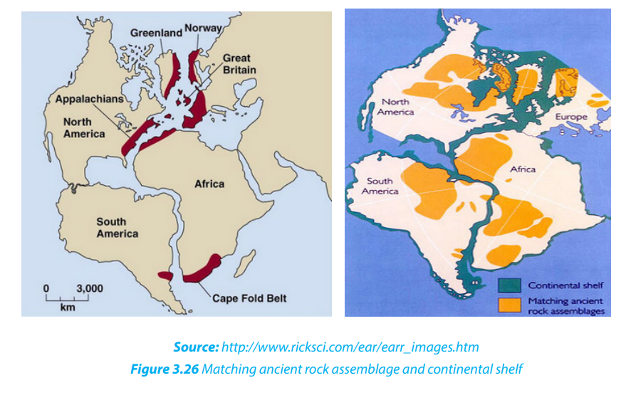
i. Geological evidence A good fit of edges of continents and
similar rock structures are found on different continents.
For example:
• East coast of South America and the Western Coast of Africa
have good visual fits, both at the surface (1000 m) and depth (2000 m).
• Both Africa and South America are composed of rocks of varying
ages and there is a convincing boundary joint across the two
continents between Accra and Sao Louis in Brazil and,
dividing Pan-African rocks and Elaurean rocks.
This evidence constitutes what is commonly known as “matching geology”
• Parts of Appalachian Mountains of the United States of America are similar
to those found in Greenland and Western Europe;
• The fact that rock particles have magnetic properties allowed geophysicists
to reconstruct the position of the poles in past times and also the probable
climatic lay belts of the past. From this, it appears that Southern Africa and
South America lay within the Arctic circle of Permian and carboniferous times
and that during the Triassic period, the continents had moved some 40° closerto the Equator.
ii. Biological evidence
There is similarity in the fossils and vegetation remains found on the eastern coast of
South America and the Western coast of Africa. For example;
• Mesosaurus was small reptile living in Permian time (280 million of years before
present); its remains have been found only in South Africa and Brazil.
• Remains of Glossopteris, a plant which existed when coal was being formed
has only been located in India and Antarctica. These animals and plants could
not have swum across oceans if continents were separated by water bodies,
so continents must have been close together for them to occur on differentcontinents which probably had a similar climate.
iii. Climatic evidence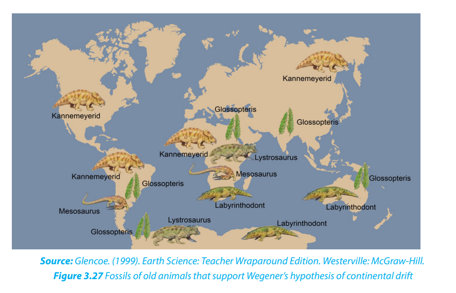
Coal formed under warm and wet conditions was found beneath the Atlantic icecap, and evidence of carboniferous glaciation had been noted in tropical and central
India. For example;
• Coal could not have been formed in Britain with its present climate.
• Peninsular India, Australia and Antarctica further prove the unification of all
landmasses in one landmass (Pangaea) during carboniferous period.
• Groves curved on rocks by glaciers in the southern parts of landmasses
forming Gondwanaland shown by arrows on the figure below provided evidencefor continental drift.
v. Geodetic evidence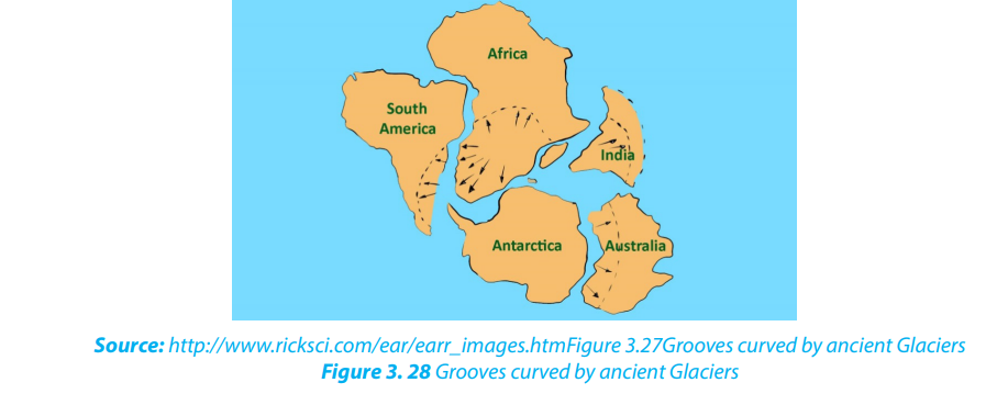
Geodetic evidence has revealed that Greenland is drifting westward at the rate of
20 cm per year. This is one of the scientific evidences arising from measurement and
representation of the earth that confirm the spread of the sea floor.
Application activity 3.2
1. Describe the rocks at the edge of the continents and show how all
continents formed a unique block.
2. Using some examples, compare the fossils of animal species and
vegetation species found on different continents by showing how they
indicate the continental drift.
3.3. Effects of continental drift on the evolution of physical features
Learning activity 3.3
Make a research and describe at least four major effects of continental drift.
The continental drift has had many effects on the evolution of physical features but
the most important are the following:
• Pangaea split apart into a southern landmass,
Gondwanaland and the northern landmass called Laurasia;
later the two super continents split again into
land masses that look like present day continents.
• Continental drift has also affected the earth’s climate. The climate of different
part of the world has changes throughout the year;
• Continental drift has affected the evolution of animals. The rearrangement
and displacement of huge landmasses has helped create the diversity which
we see present in modern day animals.
• Collision of earth crusts. The collision of the Indian subcontinent and Asian
continent created the Himalayan mountain range, home to the world’s highest mountain peaks.
• Formation of rift valleys. Rift valleys are sites where a continental landmass is
ripping itself apart. Africa, for example, will eventually split along the western
Great Rift Valley system.
• Continental drift is the major cause of earthquakes, volcanoes,
oceanic trenches, mountain range formation, and other geologic
phenomenon which created the new landscapes on the earth’s surface;
A3.4.3. Boundaries and movement of tectonic plates i. Tectonic Plate boundaries Boundaries of plate tectonic include the subduction zone, the mid-ocean ridge and the transform boundary. • Divergent boundary (Mid-ocean ridge): It is an underwater mountain range which is formed when forces within earth spread the seafloor apart. It is created when convection currents rise in the mantle beneath where two tectonic plates meet at a divergent boundary, thus forming the oceanic ridge. • Transform boundary (Transform fault): It is a boundary which exists between two plates that are sliding horizontally past one another, thus forming the transform faults (see the figure below).pplication activity 3.3
Explain the effects of continental drift on the evolution of physical landscape of
the earth.
3.4. Plate Tectonics
Learning activity 3.4Observe the illustration below and answer the following questions:
Source: Waugh, D. (2009). Geography: An Integrated Approach. London: Nelson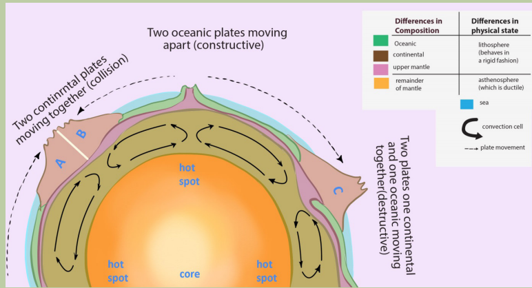
Thornes.
1. Identify the types of crust found on the map
2. Describe the difference between lithosphere and asthenosphere
3. Differentiate collision, constructive, and destructive processes
4. Determine the position of plate movements5. Explain how convection cells cause the movement of plates
The word tectonic comes from the Greek word ‘tektonikos’ meaning building
or construction; this means how the earth crust is constructed. Therefore, plate
tectonics refers to the deformation of the earth’s crust, because of internal forces,
which can form various structures in the lithosphere.
The plate size can vary greatly, from a few hundred to thousands of kilometers across.
Plates are moved by the energy originating from the earth interior. This energy
is a result of convection currents which form convection cells. Tectonic plates are
irregularly shaped slabs of solid rocks, generally presenting two types: Continentalcrust and Oceanic crust as shown on the figure below.
Tectonic processes include tension when plates diverge and compression when
plates converge. These processes result in deformation of the earth crust. Tension
causes fracturing and faulting of the crust while compression produces folds andover thrust faults.
3.4.2. Types of Plate Tectonics
There are two types of plate tectonics: continental plate and oceanic plate.
i. Continental crust is composed of older, lighter rock of granitic type: Silicon
and Aluminum (SIAL).
ii. Oceanic crust consists of much younger, denser rock of basaltic
composition: Silicon and Magnesium (SIMA). The major differences
between the two types of plates are summarized in the table below:Difference between continental plate and oceanic plate
3.4.3. Boundaries and movement of tectonic plates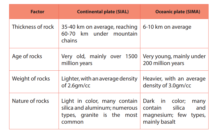
i. Tectonic Plate boundaries
Boundaries of plate tectonic include the subduction zone, the mid-ocean ridge and
the transform boundary.
• Divergent boundary (Mid-ocean ridge): It is an underwater mountain
range which is formed when forces within earth spread the seafloor apart. It
is created when convection currents rise in the mantle beneath where two
tectonic plates meet at a divergent boundary, thus forming the oceanic ridge.
• Transform boundary (Transform fault): It is a boundary which exists between
two plates that are sliding horizontally past one another, thus forming thetransform faults (see the figure below).
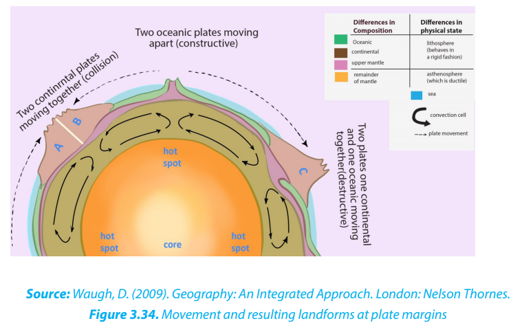
• Convergent boundary (Subduction zone): This is the area where an ocean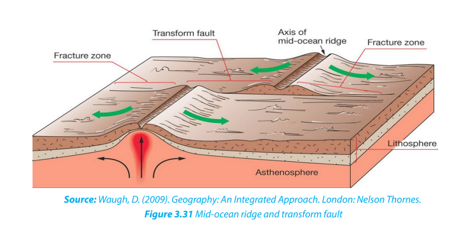
floor plate collides with a continental plate and the denser oceanic plate sinksunder the less dense continental plate, thus forming the oceanic trench.
ii. Tectonic plate movements
Plate movements include convergence, divergence and way past movementalong the transform fault.
• Convergence is a movement whereby two crustal plates are colliding or one
subsiding beneath the other. The margin where this process occurs is known as
a destructive plate boundary. This boundary is a region of active deformation.
• Divergence is a movement whereby two crustal plates are moving away from
each other. The margin where this process occurs is known as a constructive
plate boundary. It initially produces rifts which eventually become rift valleys.
• Way past is plates’ movement predominantly horizontal, where crust is neitherproduced nor destroyed as the plates slide horizontally past each other.
The plate movements are characterized by the following:
• Due to its relatively low density, continental crust does not sink; but it is the
oceanic crust which is denser that can sink. Oceanic crust is then formed and
destroyed, continuously;
• Continental plates, such as the Eurasian plate, may consist of both continental
and oceanic crust;
• Continental crust may extend far beyond the margins of the landmass;
• Plates cannot overlap. This means that either they must be pushed upwards
on impact to form mountains, or one plate must be forced to downwards into
the mantle;
• No gap may occur on the earth’s surface so, if two plates are moving apart new
oceanic crust originating from the mantle is formed;
• The Earth is neither expanding nor shrinking in size. Thus, when the new
oceanic crust is being formed in one place, older oceanic crust is being
destroyed in another;
• Plate movement is slow and is usually continuous. Sudden movements are detected as earthquakes;
• Most significant landforms (folded mountains, volcanoes, insular arcs deep seatrenches, and batholith intrusion) are found at plate boundaries.
3.4.4 Characteristics of plate tectonics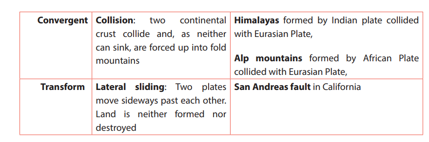
Tectonic plates are characterized by the construction and destruction of landforms
at margins of plates. However, at some boundaries, the construction or destruction
may not occur. These are called passive margins or conservative boundaries.
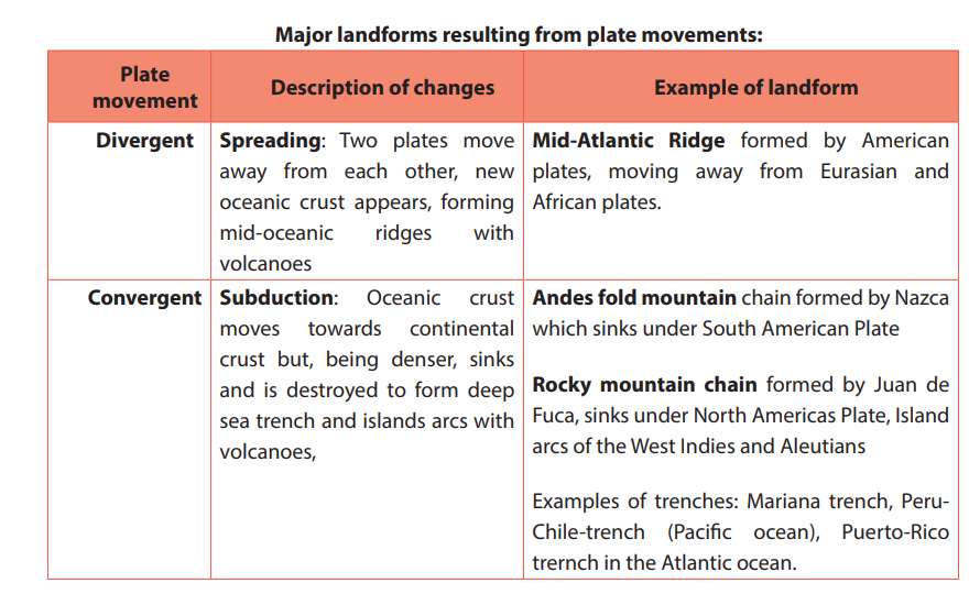
i. Constructive landforms
Constructive landforms occur where two plates diverge, or move away from each
other, and a new crust is created at the boundary. They are formed in the following
ways:
• This occurs when a continent ruptures and the two new plates move apart and
create a new ocean.
• The crust is uplifted and stretched apart, causing it to break into blocks that
become tilted on faults. Eventually a long narrow rift valley appears.
• Magma rises up from the mantle to continually fill the widening crack at the
center (A) as presented on figure below.
• The magma solidifies to form new crust in the rift valley floor.
• Crustal blocks on either side slip down along a succession of steep faults, creating mountains.
• A narrow ocean is formed, floored by new oceanic crust (B)as presented onfigure below.
• The ocean basin can continue to widen until a large ocean has been formed
and the continents are widely separated.
• The ocean basin widens, while the passive continental margins subside and
receive sediments from the continents.
• As the plates diverge, molten rock or magma rises from the mantle to fill anypossible gaps between them, creating new oceanic crust.
• The magma initially forms submarine volcanoes which may in time grow
above sea-level. Volcanic islands are created by the submarine volcanism atthe vertical of oceanic ridge, e.g. Iceland (see the figure below).
ii. Destructive landforms
Destructive landforms occur where continental and oceanic plates converge. They
are formed in the following ways:
• The oceanic plate that is denser is forced to dip downwards at an angle to form
a subduction zone with its associated deep-sea trench.
• The sunk plate will melt and transformed into magma as the pressure and the
temperature rise.
• The newly created magma will try to rise to the earth’s surface. Where it does
rich surface volcanoes will occur. This process will either create a long chain
of fold mountains (e.g. the Andes) or, if the eruptions take place off shore, an
Island arc will be created(e.g. Japan, Caribbean).
iii. Passive or conservative margins: Passive continental margins are: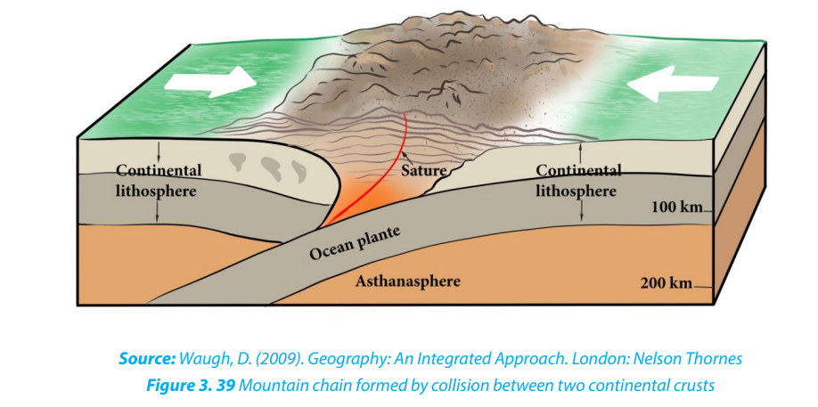
• The areas which are lacking active plate boundaries
at the contact of continental crust with oceanic crust.
• The transform faults which are large cracks produced at right-anglesto the plate boundary because neither landform is constructed nor destroyed.
Application activity 3.4
1. Describe SIAL and SIMA in terms of thickness, age, weight and nature of
rocks
2. Explain the difference between convergent movement, divergent
movement and way past movement
3. Describe the subduction, collision, spreading processes and give
their effects and corresponding motions in relation to plate tectonic
movements.
4. Explain the processes that lead to constructive and destructive landforms
3.5. Major plates and effects of plate tectonics
Learning activity 3.5
1. Make research using books and a printed hand out and represent on the
world map the major tectonic plates.2. Identify the effects of the plate tectonic?
3.5.1. Major tectonic plates of the world
The following are the major tectonic plates of the world:
i. The Pacific plate which covers a large part of the basin of Pacific Ocean.
ii. The Eurasian plate located between the northern mid-ocean ridge of the
Pacific Ocean and the Pacific and Philippines Plates margins.
iii. The North American plate bordered by the eastern margin of the Pacific
plate in the West and mid-ocean ridge of the Atlantic Ocean in the East.
iv. The South American Plate located between the subduction zone of
Nazca plate in the West and the mid-ocean ridge of the Atlantic Ocean in
the East.
v. The African plate located between the mid-ocean ridge of the Atlantic
Ocean in the West and the mid-ocean ridge of Indo-Australian plate in the
East.
vi. The Indo-Australian plate extends around the Australian subcontinent,
between the Pacific plate and the African Plate.
vii. The Antarctic plate corresponds with the Antarctic continent around the
South Pole.
viii. The Nazca Plate which is located between the Pacific plate and the South
American plate.
However, several minor plates, about 20 have been identified (e.g. Arabian plate,
Bismarck plate, Caribbean Plate, Carolina plate, Cocos plate, Juan de Fuca plate, Nazcaor East Pacific plate, Philippines plate, Scotia plate among others).
3.5.2. Effects of plate tectonics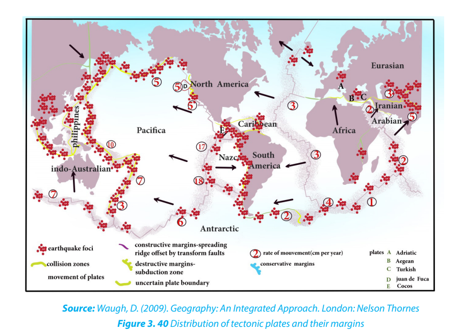
The following are the main effects of plate tectonics:
i. Earthquake
This is a series of vibrations induced in the earth’s crust by the abrupt separation
and echo of rocks in which elastic strain has been slowly accumulating. This sudden
violent shaking of the ground typically causes great destruction, because of
movements of seismic waves within the earth’s crust.
Most earthquakes occur as the result of the sudden movement along a fault line
between two adjacent tectonic plates. These have several impacts like landscapemodification, destruction of houses, tsunamis, etc.
ii. A volcanic eruption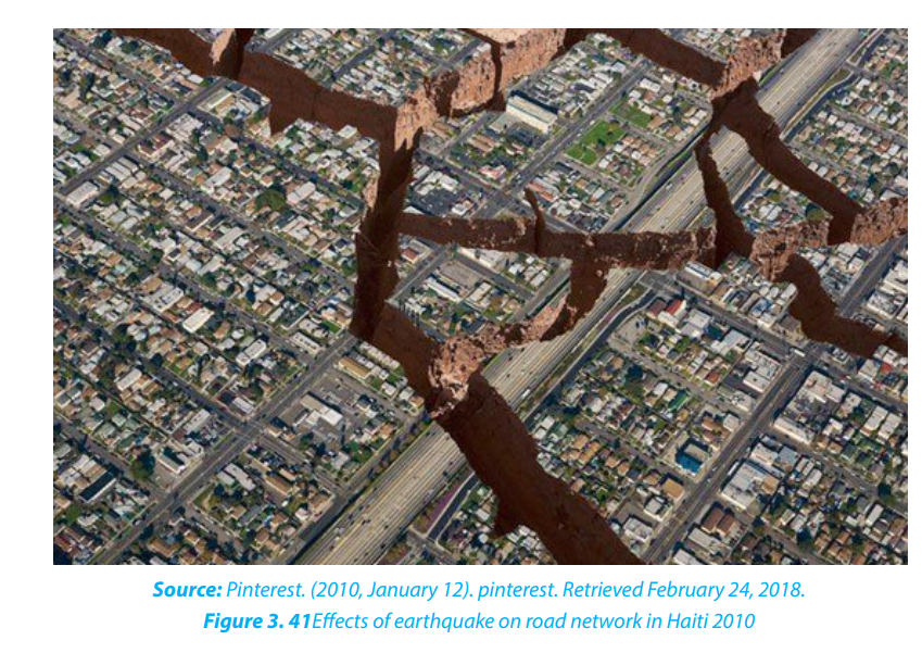
A volcanic eruption occurs when hot materials (molten materials) are thrown out of
a volcano. Lava, rocks, dust, and gas compounds are some of these materials which
are ejected out during volcanic eruption. Volcanic eruption take place when a plate
moves over the top of another plate, then the energy and friction melt the rock andpush it upwards.
iii. Tsunamis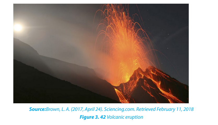
Tsunamis are giant waves, often generated at destructive plate margins that can cross
oceans. They occur when a sudden, large scale change in the area of an ocean bed
leads to the displacement of a large volume of water and the subsequent formation
of one or more huge waves. When a major seismic tremor occurs underneath a body
of water, the energy from that tremor is released into the surrounding liquid. The
energy spreads out from its original site, traveling through the water in the form of
a wave.
Tsunamis have exceptionally long wave-length up to 10 km and can cross oceans
at speeds of up to 700 km/hour but can sometime be imperceptible when theirmagnitude is low.
Application activity 3.5
1. Conduct your own research to identify the minor tectonic plates of the
world and locate them geographically.
2. Apart from the distribution of the continent, what are other effects of
plate tectonics.
3. Identify the major seismic and volcanic zones in the world and explain the
impact of those natural hazards referring to the tectonic plates.
4. Our country, Rwanda, is in a region which is tectonically active and
subjected to earthquakes events. The more documented earthquake
is the one which occurred on 3rd and 4th February 2008. It occurred on
Sunday about 09h31 with the magnitude of 6.1 and 5, and on Monday
the 4th February 2008 and affected mostly Nyamasheke and Rusizi
Districts, Western Province. 37 people died, and 643 injured including
367 traumatized. Many houses were destroyed in these two Districts
where 1,201 families were rendered homeless:
5. Knowing the causes of the earthquake, explain how Rwandans can copewith it and its impacts and other resulting natural hazards.
3.6. The theory of Isostasy
Learning activity 3.6
1. Make research and explain the isostasy theory.2. Explain isostasy based on the figure below.
3.6.1. Meaning of Isostasy
The concept of Isostasy comes from “iso” = equal, and “stasis” = equilibrium. It
describes how various continental and oceanic crusts, stay in equilibrium over the
asthenosphere. The following are the main characteristics of isostasy:
• By isostasy, the lighter crust must float on the denser underlying mantle.
• It explains how different topographic heights can exist on the earth’s surface.
• Isostatic equilibrium is an ideal which states where the crust and mantle would
settle in equilibrium in absence of disturbing forces.
• Isostasy theory is concerned with vertical movements of plates which depend
on lithospheric masses.
• The loading of crust by ice or sediments may cause the subsidence of
lithosphere, whereas the discharge resulting from ice melting or erosion may
cause the uplift of lithospheric compartment.
• The waxing and waning of ice sheets erosion, sedimentation, and extrusive
volcanism are examples of processes that perturb isostasy.
• Isostasy controls the regional elevations of continents and ocean floors in
accordance with the densities of their underlying rocks.
3.6.2. Main theories of Isostasy
There are two main theories which have been developed to explain how Isostasy
acts to support mountain masses.
i. Pratt’s theory: The theory stipulates that there are lateral changes in rock
density across the lithosphere (crust). If the mantle below is uniformly
dense, the less dense crustal blocks float higher to become mountains,whereas the denser blocks form basins and lowlands.
ii. Airy’s theory: According to Airys’s theory, the rock density across the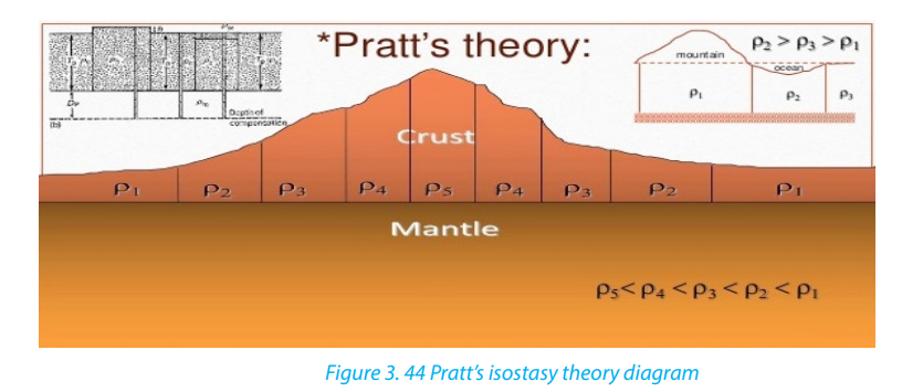
lithosphere is approximately the same but the crustal blocks have different
thicknesses. Therefore, mountains that shoot up higher also extend
deeper base into the denser material beneath.
Both theories predict a relative deficiency of mass under high mountains. Airy’s theory
is now known to be a better explanation of mountains within continental regions,
whereas Pratt’s theory essentially explains the difference between continents and
oceans, since the continent crust is largely of granitic composition which is less
dense than the basaltic ocean basin.
Application activity 3.6Referring to Pratt’s theory and Airy’s theory, explain the principle of Isostasy.
End unit assessment
1. What is the contribution of Wegner’s theory and others on the
distribution of continents?
2. Basing on the knowledge acquired in this unit, explain the relationship
between the earthquakes which occur in the region of the western rift
valley of Africa where Rwanda is located, with the continental drift.
3. Using a map represent graphically the main tectonic plates of the world
map.
4. Discuss the consequences of the plate tectonics on population in somespecific areas of the world.