Unit 2: : INTERPRETATION OF PHOTOGRAPHS AND VIDEO IMAGES
Key Unit Competence:
By the end of this unit, I should be able to interpret photographs, video images and
draw sketches by reduction or enlargement of the photographs.
Introductory activity
In the previous unit, it was shown that maps are very important tools to indicate
and to describe physical and human features. Describe other ways used in
geography to show physical and human features.2.1. Definition and types of photographs
2.1.1. Definition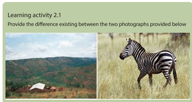
A photograph is a picture of an object or environment taken by a camera at a particular
time in a given place. Photographs are ways of recording geographical information.
They enhance the understanding of reality. However, when a photograph is taken,
some parts of the object or environment are seen while others may not be seen
clearly. A hidden ground/area which cannot be seen by a camera when a photographis taken is called a dead ground.
2.1.2. Major types of photographs
There are two major types of photographs: Terrestrial/ close or ground photographsand Aerial photographs.
Ground photographs: These are photographs taken from the ground level. They
record exactly what a person would see if he / she was standing on the ground level.
A ground photograph gives a horizontal view, great details of the landscape and
covers a small area. There are two categories of ground photographs:
i. Ground horizontal photograph: This is a photograph taken when a
camera is held horizontally to the ground.
ii. Ground oblique photograph: This is a photograph taken when thecamera is titled at an angle facing the ground.

Aerial photographs: These are photographs taken from aerial station using
aircrafts, satellites, and other flying objects. They cover a wide area, features are
greatly reduced, show the top of the object, do not show the horizon. There are two
categories of aerial photographs:
i. Vertical aerial photographs: These are photographs taken when the
camera is directly above (overhead) the objects or when it is perpendicularto the ground.
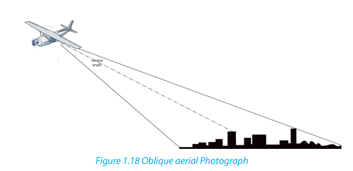
ii. Oblique aerial photographs: These are photographs taken when the
camera is titled at an angle below 90 degrees.
2.2. Sections of a photograph and interpretation of physical and human
aspects
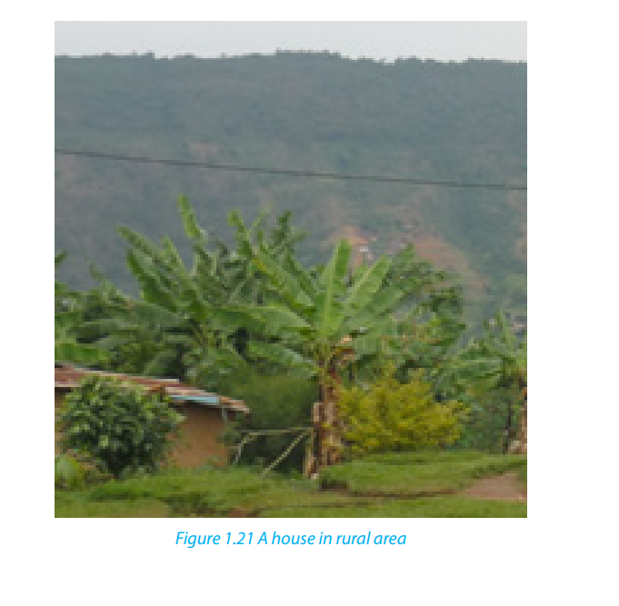
Learning activity 2.2Observe the photograph below and answer the following questions:
1. Identify the physical and human features shown on the above photograph.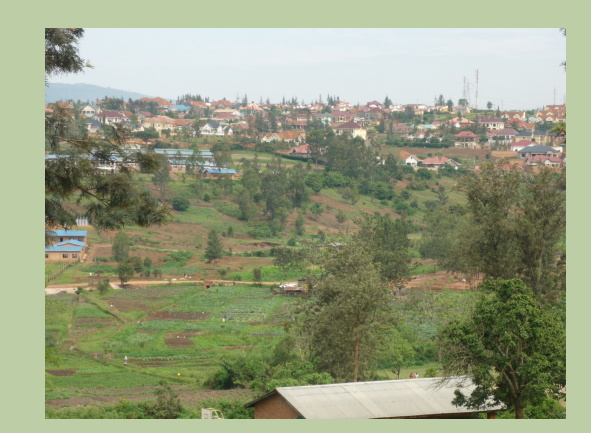
2. Indicate the respective parts where these features are found in the abovephotograph.
2.2.1. Sections of a photograph
From a horizontal perspective, photographs fall under three categories as indicated
below:
• The foreground: It is the part of the photograph located nearest to the camera.
• The middle ground: It is the central part of the photograph.
• The back ground: It is the farthest part of the photograph that includes the
horizon.
From vertical perspective, photographs are also divided in three parts: left, centerand right.
Combining both horizontal and vertical perspectives, the photographs can be put
into the following categories:
Categories of photographs depending on the position of photography
2.2.2. Interpretation of physical and human aspects on photographs and
video images
Physical and human aspects on photographs and video images can be interpreted
as follows:
a. Interpretation of physical aspects
i. Climate: Climate in a photograph is indicated by rainfall and temperature. Heavy
rainfall can be observed by presence of dense forests and crops like sugar cane,
rice and tea while high temperature may be observed by the presence of poor
vegetation, people wearing light clothes etc.
ii. Relief: The features of the relief depicted on a photograph include mountains,
hills, valleys, escarpments, plateaus and plains. A hilly or mountainous landscape
is indicated by the presence of steep slopes, presence of terraces, snow and
glaciers on the top. Plateaus and plains are identified by a uniformly flat land with
sloping edges and pools of water or irrigated land. Wide valleys with meanders
and flood plains also suggest the presence of plain land.
Relief on vertical aerial photographs can be interpreted by observing the following:
• Flat areas can be identifiable by the presence of meandering rivers, straight
roads and gentle bends.
• Plateaus can be indicated by presence of flat topped hills.
iii. Vegetation: This is the plant life that covers the earth surface; it is both natural and
artificial. When describing vegetation on a photograph, the aspects to consider
are the type of vegetation whether grassland, scrub or thicket; the tree species
such as baobab, acacia, eucalyptus; the density of the vegetation whether trees
are close together or scattered; and the nature of the vegetation whether human
made or natural.
iv. Drainage: Drainage is shown by the presence of water bodies on a photograph,
such as streams, rivers, lakes, swamps, seas, and oceans. Others are man-made
water features like wells, ponds, valley dams and boreholes. In photographs,
drainage is interpreted in the following ways:
• Rivers appear with meandering channels with swampy vegetation along them.
• Swamps appear with luxuriant vegetation dominated by papyrus reeds.
v. Soils: The types of soils can be identified by observing the types of crops grown
there because there are crops that grow well in specific types of soils, for
example, tea and coffee grow well in fertile volcanic soils. Where erosion
took place, the soils are exposed.
b. Interpretation of human aspects
Photographs and video images can be very useful in the interpretation of human
activities such as:
i. Forestry: A forest is evidenced by the presence of both artificial and
natural forests.
ii. Agriculture: Agricultural activities can be observed by the presence of
food crops and cash crops as well as animals like cattle both exotic and
traditional breeds.
iii. Transport and communication: Both transport and communication
networks are evidenced by presence of motor vehicles, bicycles, roads,
ships, airports, and communication facilities such as telephone lines and
masts.
iv. Mining: This is shown by Open pits, people undertaking mining or a
mineral processing plant show that there is mining taking place in that
area.
v. Industry: Industrialization is shown by the presence of industries emitting
smoke from huge chimneys.
vi. Trade or commerce: the commerce is evidenced by trading centers with
congested buildings and at times presence of markets.
vii. Settlement: It is evidenced by the presence of houses in differentpatterns.

2.3. Drawing sketches of photographs by reduction or enlargement
A sketch of a photograph focuses on the identification, marking using symbols and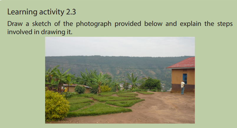
labeling marked features in their relative positions. Sketching takes into account
physical and man-made features and should reflect the proportional size of features.
To draw a sketch of a photograph by enlargement or reduction requires the following
steps:
i. Draw a rectangle and a square of the size as requested on a piece of paper.
ii. Draw horizontal lines across the photograph by using a pencil to
subdivide it into three equal sections. These will be the foreground, middle
ground and background either reduced or enlarged as instructed.
iii. Draw vertical lines across the photograph by using a pencil. These will be
left, centre and right.
iv. Place the framework of a photograph onto the prepared rectangle or
square. The framework could be the guider in placing the various features
in their respective positions.
v. Enlarge or reduce the size of features and the frame as requested.
vi. When filling in the main features, it is better to start with the background
or right by drawing the skyline as it appears on the photograph.
vii. It is better to place and label all important features either physical or
human as they appear on the photograph, reduce or enlarge them as
required.
viii. Choose a suitable title, key, orientation of a sketch. It is possible to put on
a sketch other elements of a sketch map which are useful in reading and
interpreting it.Therefore, a sketch of a photograph can be enlarged or reduced as shown below:


2.4. Relationship between physical and human aspects on photographs
and video images
Learning activity 2.4
Describe the relationship between physical and human features represented onthe photograph below.
Some photographs and video images help in showing the relationship between
human and physical aspects. The relationship between human and physical aspectis discussed basing on the photograph below:
i. Relief and transport: Transport routes occur on gentle slopes and avoid
steep slopes and valleys since it is very expensive to construct roads in hilly
areas.
ii. Relief and agriculture: On steep slopes, less agriculture takes place while
on gentle slopes most agricultural practices are observed. The low lands
are usually reserved for growing of vegetables, sugar cane, rice, and other
crops that need enough water.
iii. Relief and settlement: Settlements are commonly found in gentle slopes
and are few in steep slopes and valleys because of the problem of severe
soil erosion and flooding in valleys.
iv. Drainage patterns and settlement: Settlement occurs in well drained
areas and avoids lake shores or river banks because of floods and associated
problems.
v. Drainage and transport: Transport routes are usually found in well drained
areas. For example, roads cannot be constructed in swampy areas due to
excessive water. Water transport occurs on water bodies like rivers, lakes,
oceans and seas.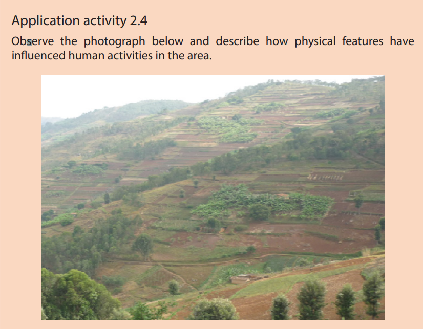
End unit assessment
1. Explain the key guidelines followed in drawing a sketch of a photograph.
2. Study the photograph provided below and answer the following
questions:
a. Identify the economic activities taking place and describe their
importance to the people living in the area.
b. Suggest ways of conserving the area in the background of the
photograph for environmental sustainability.