UNIT 15 ENVIRONMENTAL CONSERVATION AND TOURISM
UNIT 15: ENVIRONMENTAL CONSERVATION AND
TOURISM
Key unit competence:
By the end of this unit, I should be able to evaluate the impact of conserving natural
resources and tourism on the sustainable development in the different countries of
the world.
Introductory activity:
Observe the photograph below and answer these questions:
1. Identify the economic activity taking place in the photograph.
2. Describe the vegetation shown in the foreground of the photograph.3. Why is it important to conserve wildlife in national parks?
15.1. Definition, components and factors of environmental degradation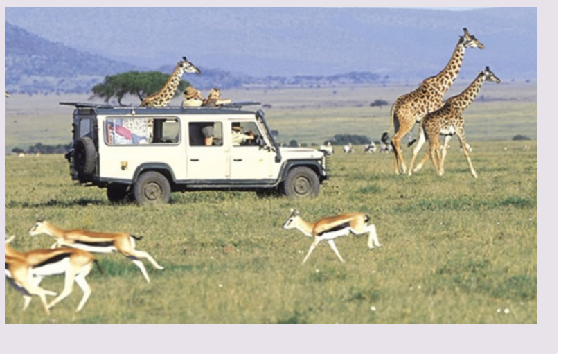
Learning activity 15.1:
a. Identify the physical features shown on the photograph above.
b. Explain human and physical factors that accelerate environmentaldegradation.

a. Definition of the environment
The word Environment is derived from the French word “Environ” which means
“surrounding”. Ordinarily, environment refers to all things that surround us. Our
surrounding includes biotic factors like human beings, plants, animals, microbes
and abiotic factors such as light, air, water, soil, etc.
Environmental degradation refers to the deterioration of the Earth’s natural
surroundings because of excessive exploitation of the available resources: water, air,
flora, fauna, soil etc.
Environmental conservation is the act of protecting the environment againstdestruction.
b. Components of the environment
- Abiotic environment: It includes all non-living things like rocks, minerals,
water, weather conditions.
- Biotic environment: It includes all living things like plants, animals, Microorganisms.
c. Factors responsible for environmental degradation:
• Overpopulation: Rapid population growth puts strain on natural resources
which results in degradation of our environment. Mortality rate has gone
down due to better medical facilities which have resulted into increased
lifespan. A big population simply means more demand for food, clothes and
shelter. You need more space to grow food and provide homes to millions of
people. This results into deforestation which is another factor of environmental
degradation.
• Pollution: Pollution, in whatever form, whether it is air, water, land or noise is
harmful for the environment
• Deforestation: Deforestation is the cutting down of trees to make way for
more homes and industries. Rapid growth in population and urban sprawl are
two of the major causes of deforestation. Apart from that, use of forest land
for agriculture, animal grazing, forest harvesting for fuel wood and logging are
some of the other causes of deforestation. Deforestation contributes to global
warming as decreased forest size puts carbon back into the environment.
• Swamp reclamation: The extensive drainage of swamps or wetlands has
serious effects on the environment. This has resulted into inadequate water
supply and the drained areas soon become arid.
• Bush burning: This is done by different societies for different reasons. Burning
of the vegetation results into the land being left bare thus the exposure of the
top soil to wind and running water hence erosion and soil deterioration.
• Urbanization: Urbanization refers to the increase of population in urban
areas and the horizontal expansion of urban areas. Urbanization is, therefore,
associated with the expansion of the city over the natural environment, the
increase of traffic congestion, smoke, acidic rainfall, global warming, etc.
• Extraction of minerals: Mining and quarrying of rocks lead to exhaustion
of minerals, destruction of scenery beauty, increased pollution, mining
operations release effluents that contaminate water.
• Natural Causes: Things like avalanches, quakes, tidal waves, storms, and
wildfires can destroy nearby animal and plant groups to the point where theycan no longer survive in those areas.
Application activity 15.1
Compare the main factors of environmental degradation between the city ofKigali and the Northern province of Rwanda.
15.2. Consequences of environmental degradation, methods of
environmental conservation and importance of environmentalconservation.
Learning activity 15.2:
1. Observe the photograph above and identify the phenomena that took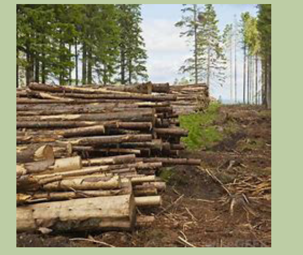
place in this area.
2. Explain the effect of the human activity shown on the photographabove on the environment.
a. Consequences of environmental degradation
• Deforestation reduces rainfall, drives climate change and desertification. This
creates severe climatic conditions that impact on various human activities
mainly agriculture.
• Flooding destroys agricultural land, crops, loss of properties, lives and
contaminates safe drinking water.
• Accelerated soil erosion due to deforestation making the land to become
unproductive.
• Increased landslide leads to large expanses of bare land and this limit human
occupancy.
• Silting of rivers, seas and oceans this has led to reduction in size of water bodies
and this affect the climate of the surrounding areas and the productivity of the
land.
• Increased sedimentation: This leads to the reduction of water levels in river,
streams, swamps and lakes and finally the occurrence of drought.
• Increased global warming: This leads to gradual rise in world temperature
which destroys Ozone layer, high evaporation rates and aridity.
• Desertification: This reduces the land productivity due to the spread of desert
- like conditions such as very low rainfall, high temperature and low humidity.
• Impact on human health: Areas exposed to toxic air pollutants can cause
respiratory problems like pneumonia and asthma. Millions of people have
died of indirect effects of air pollution.
• Biodiversity loss: This is the reduction of large plants and animals. Biodiversity is
important for maintaining balance of the ecosystem in the form of combating
pollution, restoring nutrients, protecting water sources and stabilizing climate.
Deforestation, global warming, overpopulation and pollution are some of the
major causes for loss of biodiversity.
• Ozone layer depletion: Ozone layer is responsible for protecting earth from
harmful ultraviolet rays. As the ozone layer will deplete, it will emit harmful
radiations back to the earth.
• Loss for tourism industry: Environmental damage in the form of loss of green
cover, loss of biodiversity, huge landfills, increased air and water pollution can
be challenges to tourism.
• Economic impact: This is when the country invests much money to restore
degraded zones. For examples, the government of Rwanda is spending much
to assist people affected by recurrent natural hazards. The economic impactcan also be in terms of loss of tourism industry.
b. Methods of environmental conservation• Environmental education and awareness through the mass media (radios,
The conservation of the environment can be done through different ways such as
the following:
newspapers, etc).
• Introduction of better farming methods which help to maintain soil fertility
and to prevent soil erosion.• Enacting of laws protecting the environment like forest, wetlands, wildlife, etc.• Establishment of national parks and wildlife reserves to protect the wild
animals.
• Developing alternative sources of energy like solar energy, hydro- electric,biogas energy etc.
• Treatment of industrial wastes before discharge into lakes, rivers, oceans etc.
• Afforestation and reforestation as trees help to protect catchment areas, control
surface run off and the balance of weather and the ecosystem in general.
• Controlling population growth and its negative effects through birth controland family planning.
c. Importance of environmental conservation
Environmental conservation is important for many reasons, including protecting
the ozone layer, maintaining animal and human food chains and making efficient
use of non-renewable resources. It saves our natural resources, reduces pollution,
preserving potable water, by saving water we would be saving the lives of plants,animals and mankind. That’s how conservation would benefit the environment.
Application activity 15.2:
1. Identify the negative impacts of environmental degradation in your area.2. Describe the areas of Rwanda that mostly experience environmental degradation and suggest the measures to be taken for environmental conservation.
15.3. PollutionLearning activity 15.3:
The term pollution may be defined as all processes that lead to the contamination
of the environment or the introduction of contaminants in the environment that
causes instability, disorder, harm or discomfort to the eco-system.
15.3.1. Main types of pollution
i. Air pollution: This refers to all harmful substances that can be transported in
the air we breathe such as smoke, car-fumes, etc. which cause health issues
to people and animals or affect property.
ii. Water pollution: This refers to all the processes that lead to the addition of
toxic and harmful substances like industrial effluents to both surface and
underground water thereby, contaminating it and making it less safe for
use.
iii. Land/soil pollution: This is a process of increasing dumping of waste
materials on/to the land such as agricultural fertilizers, industrial wastes,
etc.
iv. Noise pollution: This is the harmful or annoying level of noise. It is common
in urban centers where there are many vehicles, big trucks, trains and nearairports and industries.
15.3.2. Causes of pollution• Fossil fuels such as coal, oil and petroleum, is the leading cause of the15.3.3. Effects of pollution
greenhouse effect and is responsible for rising of global temperature.
• Gases emitted by automobile contain unburned hydrocarbons, carbon dioxideoxide of nitrogen that contributes to acid rain, smog and global warming.
• Chemicals such as pesticides, herbicides used in farming activities pollute the
soils while killing micro-organism in an area.
• Disposal of garbage from large cities leads to the contamination of land. The
garbage consists of high synthetic and plastic materials that take longer to
decompose than the primary biodegradable waste materials.
• Industries discharge their wastes into nearby water bodies thus polluting
them.
• Nuclear tests done in open water surfaces pollute them hence affectingaquatic life.
• Pollution leads to the reduction of fresh air which is very vital for humanity and15.3.4. Solutions to the problems of pollution
animals during respiration.
• It is the main factor of global warming or greenhouse effect, water borne
diseases such as typhoid, cholera and bilharzia.
• Air pollution leads to air borne diseases of respiratory system such as bronchitis,
lung cancer, and tuberculosis.
• Heavy pollution affects visibility which can cause traffic accidents.
• It also leads to the formation of acid rain. When such rain reaches the ground,
it pollutes and spreads pollution even into surface and underground water
bodies.
• Destruction of the Ozone layer due to different gases emitted in the atmosphere.
Therefore, dangerous solar radiations reach the earth surface.
• Soil pollution leads to the formation of barren land, which is not productive
unless fertilizers and soil additives are utilized.
• The use of atomic bombs results into the pollution of the land reducing itsproductivity as well as malfunctions of the human bodies.
• Treatment of the pollutants before their disposal so as to reduce the degree ofApplication activity 15.3:
toxicity and harm they can have on the water bodies.
• Setting laws to prohibit the discharge of toxic wastes into international water
bodies.
• Building of sea wages treatment plants before it is discharged into lakes and
river
• Car manufacturing countries are redesigning their car engines and exhaust
systems so as to ensure further combustion and thereby reduction in the level
of concentration of toxic gases.
• Clean up areas where oil spills, a cleaning exercises has been undertaken to
remove oil substance from the surface of the water and make water clean.
• The issue of nuclear test can be overcome by signing several treaties through
organizations like United Nations and NATO.
• Introduction of environmental friendly techniques of controlling weeds and
pests such as physical and biological methods.
• Construction of elongated chimneys high into the sky will protect thesurrounding areas from the immediate disastrous effect of pollution.
Describe the human activities that accelerate pollution in your environmentand suggest measures to reduce pollution.
15.4. Catastrophes
Learning activity 15.4:
On May 4, 2018, the Online Journal Umuseke.com reported that within the
last four months about 180 people lost their lives, 4000 hectares of crops,
many bridges and roads were destroyed because of natural catastrophes.
This is a serious environmental issue.
1. Referring to your knowledge on the physical and human geography of
Rwanda, what are the causes of such catastrophes in Rwanda?2. What forms of catastrophes do you observe in your local environment?
A catastrophe is a large-scale disaster or a horrible event. We have natural
catastrophes and non-natural calamities.
15.4.1. Natural catastrophesA natural catastrophe is an unexpected event, caused by nature
Table showing natural catastrophes
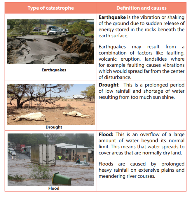
Diseases: A disease is a disorder of structure or function in a human, animal, or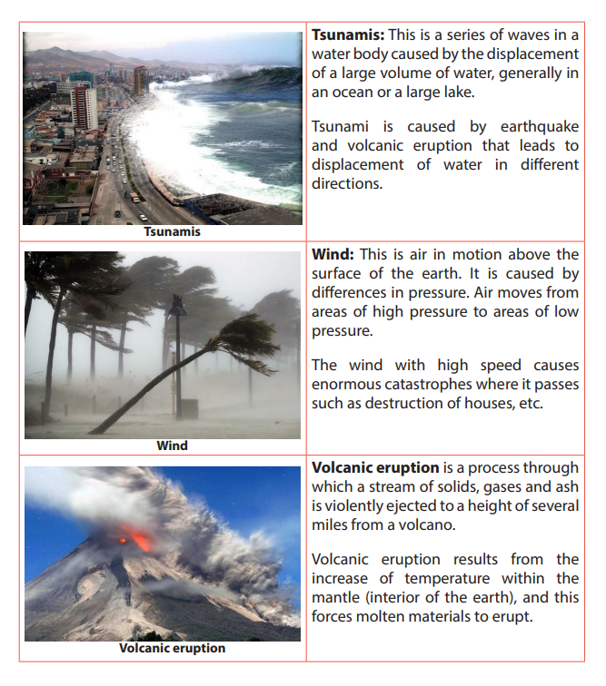
plant. It produces specific symptoms or affects a specific location and is not simply
a direct result of physical injury, e.g. cholera, tuberculosis; AIDS, etc. Poor hygienic
conditions cause diseases like cholera while disease like AIDS are caused by viruscalled Human Immune Virus (HIV)
15.4.2. Non natural catastrophes /calamities
Non-natural catastrophes: These are disasters or emergence situations of which
the principal, direct causes are identifiable human actions or deliberate causes.
i. War: It refers to a state of organized armed conflict between countries
or groups within a country. Wars are caused by misunderstanding and
mistrust between and among the parties involved. These could be flowing
from social, economic, ideological, political or cultural matters.
ii. Famine: It is a widespread scarcity of food that may apply to any faunal
species, which phenomenon is accompanied by regional malnutrition,
starvation, epidemic and increased mortality. Famine is caused by droughts,
floods, crop failure due to pests and diseases, rapid increase of population,
bad government policies and political instability.
iii. Fire: A state, process, or instance of combustion in which fuel or other
material is ignited and combined with oxygen, giving off light, heat, and
flame. High atmospheric temperatures and dryness (low humidity) offer
favorable circumstance for a fire to start.
15.4.3. Effects of catastrophes
• Loss of lives and destruction of properties. This happens when buildings fall
down due to earthquakes, floods, Tsunamis, etc.
• Droughts wither the plants and human beings face hunger and starvation.
Animals and birds die; some move away to look for food.
• Population decreases in places where catastrophes occur due to displacement
and death of people.
• Agricultural and industrial productions are negatively affected by pests and
diseases.
• Occurrence of water borne diseases like bilharzia which is caused by water
snails in stagnant water.
• Catastrophes reduce the capacity of the soil to store nutrients and water, thus
make the environment drier.
• Catastrophes can lead to mudslides, soil erosion and landslide in mountainous
areas.
• The government spends a lot of money for restoring the damages. This money
would be used in other developmental projects.
• Degradation of the crust by sediments on the earth surface by stripped soils
or the weathering of rocks at their base where they are in contact with the soil.
Geography Senior Six Student Book 421
15.4.4. Solutions to catastrophes
It is not possible to stop catastrophes. But it is possible to reduce the damage they
cause. People can do the following:
• Building terraces and channels. These help to drain the standing water.
• Droughts can be controlled by afforestation, whereby the levels of air moisture
and precipitation are increased.
• Water reservoirs can also be constructed so that they are used to irrigate the
farms and seedlings.
• Increasing roughness of the soil surface. This entails cropping techniques that
leave large clods on the soil surface or ridges perpendicular to the direction of
the prevailing wind.
• Increasing plant cover. Wind-speed can also be cut by increasing plant density.
Since this is clearly not easy in arid zones, it is particularly important to ensure
sound crop residue management, keeping residues on the ground so as to
increase roughness and protect the soil surface. This is better than ploughing
in, which would only slightly improve soil structure and resistance to wind.
• Practice modern agriculture. These include use of fertilizers, irrigation and
improve food storage facilities.
• Government must provide budget to control catastrophes. It has also to assist
farmers by giving them loans they can use to improve sustainable farming
practices and techniques.
• Prevention of human-caused fires through education and environmental
modification. This includes silviculture activities, people’s participation, and
education enforcement.
• Building houses that can resist to earthquakes.
• For the prevention of the wars, people should discuss any differences that
arise. This is good as it helps to resolve conflicts. Fighting should never be anoption.
Application activity 15.4:
1. Rwanda experiences many catastrophes each year:
a. Describe the common catastrophes in Rwanda.
b. Identify the most affected regions in Rwanda and why.
c. Explain the effects of catastrophes on sustainable development of Rwanda.
2. Identify the types of natural catastrophes common in your area andsuggest ways to mitigate them.
15.5. Tourism15.5.1. Definitions, major tourist areas of the world and factors affecting the development of tourism in the world.
a. Definitions
• Tourism is a travel from one place to another for the purpose of leisure,
research, business, instruction and education.
• Eco-tourism / ecological tourism (green tourism) is the practice of involving
the community living around the tourist attraction sites in the management
and conservation of such sites and the surrounding environment.
• Domestic tourism is whereby the local people visit places of interest within
their country for study, pleasure or recreation.
• International tourism involves organized tours by people from their countries
to other countries.
b. Major tourist areas of the world.
Our world is full of indescribable beauty, both natural and artificial, and it is unclear
whether one life really enough to really experience all that. Most of us will probably
never see anything the world has to offer us, but it’s worth a try. The most areas of
the world are:
• New York as the headquarter of international organization like United Nations,
World Bank, etc.
• Europe as a developed continent with magnificent cities such London, Paris,
Geneva etc.
• Rome, Mecca and Jerusalem as religious centers.
• Historical sites like pyramids of Egypt, Great Wall of China,
• National parks and resorts like Disney World in Florida (USA), Disney in Paris
(Europe), Akagera (Rwanda).
• Beaches in Germany, Seychelles and along coastal lands.
• Mountainous regions like Alps, Himalayas, Kilimanjaro, Rockies, Atlas,
Appalachians, Birunga in Rwanda, etc.
c. Factors affecting development of tourism in the world
• Climate: A favorable climate especially sunny condition attracts people from
cooler northern countries to tropical regions.
• Political stability favors the development of tourism as the average tourist
tends to be easily frightened away from an area with insecurity.
• Capital: Acquired funds help to develop tourist physical and human resources.
• Government policy: Governments set explicit policies of encouraging tourists
to visit their countries by creation of board which plan, market and manage the
tourism industry. This is one of the responsibilities of Rwanda Development
Board (RDB) in Rwanda.
• Accessibility: Improvement of means of transport like roads, airport, favor the
development of tourism.
• Accommodation: Tourists will be influenced to travel to those destinations
where they are assured of decent and affordable accommodation.
• Advertisement: Tourist attractions are made known to the local and
international community using mass media. This information markets wildlife
and other tourist attractions.
• A wide range of tourist attractions in a particular area attracts many touristsboth local and international tourists
Application activity 15.5.1:
1. Explain how physical features contribute to the development of tourism
industry in the world.
2. Mountain gorillas, Rwandan culture, water bodies have contributed
to the recent development of tourism industry in Rwanda. Is it true?Support your answer.
15.5.2. Importance and impact of tourism
Learning activity 15.5.2:
Read the passage below and answer the following questions:
Many tourists come to Rwanda. They bring money to consume while being in
the country. Some appreciate our culture, create friendship with Rwandans
and even when they go back to their countries they tell their friends what
they have seen in Rwanda.
1. Explain different ways tourism industry contributes to the development
of a country.
2. What can be the negative effects of tourism?
a. Importance of tourism in the world
• Tourism is a big foreign exchange earner. Countries benefit from the sale of
licenses to tour operators who are taxed on their profits and entrance fees to
tourism sites. Tax from tourist hotels is a source of revenue to governments.
• It offers employment to thousands of people in both public and private sectors.
• It enhances the development of industries particularly the accommodation
and service industries.
• It enhances the development and the general improvement of infrastructure.
Roads leading to tourist attractions are well maintained. Airstrips to such
places have been constructed.
• Improvement in the standards of living where people earn income because
tourists buy basic needs and luxuries.
• It enhances the development of international cooperation between countries.
• A profitable tourism tends to lead to renewed interest in the protection of
wildlife and natural resources so that continued existence lead to sustainable
development.
• Tourism expands market for locally produced commodities/goods. The
demand for certain items may increase as tourism develops.
b. Impact of tourism on the environment
The following are the major impacts of tourism on the environment:
• The loss of biodiversity:
- Protected animals in the national parks may escape and harm people
and damage their crops and animals.
- Tourists leave fire on the camping and picnic sites which causes damages
to vegetation. This may lead to the loss of valuable forest
• Pressure on the water resources: Water, and especially fresh water, is one of
the most critical natural resources. The tourism industry generally over uses
water resources for hotels, swimming pools, golf courses and personal use
of water by tourists. This can result into water shortages and degradation of
water supplies, as well as generating a greater volume of waste water.
• Land degradation: Important land resources include minerals, fertile
soil, forests, wetland and wildlife. Increased construction of tourism and
recreational facilities have increased the pressure on these resources and
on scenic landscapes. In areas with high concentrations of tourist activities
and appealing natural attractions, waste disposal is a serious problem and
improper disposal can be a major despoiler of the natural environment - rivers,
scenic areas, and roadsides.
• Air and noise pollution: Air and noise pollution from airplanes, cars, and
buses, as well as recreational vehicles such as snowmobiles and jet skis, is an
ever-growing problem of modern life.
• Sewage: Construction of hotels, recreation and other facilities often leads
to increased sewage pollution. Wastewater has polluted seas and lakes
surrounding tourist attractions, damaging the flora and fauna. Sewage runoff
causes serious damage to coral reefs because it stimulates the growth of algae,which cover the filter-feeding corals, hindering their ability to survive.
Application activity 15.5.2:
1. Make a field trip and discuss the impacts of tourism industry on the local
environment.
2. Tourism benefits both the country and the people living around the
visited areas or national parks. Explain this in the context of Rwanda
15.5.3. Problems affecting the tourism in the world and the prospects
Learning activity 15.5.3:
Read the following passage and answer questions that follow:
In developing countries there is high population growth; people have
begun encroaching on areas reserved for national parks and game reserves.
Poaching, deforestation is the order of the day. The need for agricultural
land and settlement has led to reduction of forested areas hence affecting
tourism.1. Identify and explain problems affecting tourism in relation to the
passage.
2. Analyse other human activities that affect tourism industry which are nota. Problems affecting tourism in the world and prospectsmentioned in the passage.
The following are the problems associated with the tourism industry:
• Climate changes: Due to global warming and climate changes, regions which
used to be well-watered and which formed favorable habitats for animals and
plants are becoming drier.
• Decline in wildlife: Incidences of poaching where animals are killed for game,
meat, skins and tusks have led to a decline in the population of wild animals.
• Encroachment on national parks due to population pressure, and this is
threatening the survival of tourism industry.
• Violence or political instability limits the number of tourists coming in the
country.
• Diseases: they destroy plants, kill wild animals and tourists. Diseases like
malaria, sleeping sickness, river blindness etc., scare away tourists.• Less supportive government policy: For example, when the governmentfails to eradicate poaching, encroaching or to set advantages that attract
tourists such as getting entry visas etc.
• Poor management skills: This is in terms of lack of skilled labors in form of
international chefs, leisure and hospitality specialists etc.
• Under developed tourist attraction sites such as historical sites, forest
without accommodation facilities, poor catering services.
• Hostility: Some individuals attack tourists and rob their properties.
b. Solutions to the problems of tourism
• Improvement of tourism facilities and amenities: transport services and
infrastructures, accommodation, security, etc.
• Making the publicity of tourist attractions through television, newspapers,
internet, etc.
• Ensuring anti- poaching and patrol: regulation against hunting and killing
of game animals and bush burning in areas gazette for wildlife have to be
institutionalized.
• Vigorous programs to control the spread of diseases.
• Training tourism workers in customer care management and service delivery.
• Enforcement of laws governing wildlife protection to ensure wildlife
sustainability to attract tourists.
• More game reserves should be gazetted where more wildlife can be protectedand conserved to ensure a variety of wildlife which attracts more tourists.
Application activity 15.5.3:15.5.4. Case studies
Show how shortage of land and poor means of transport are barriers to the
development of tourism industry in developing countries.Suggest measures being taken by Rwanda to develop the tourism industry
Learning activity 15.5.4:
Draw the world map and locate the following countries and their major
tourist attractions.
a. Switzerland.
b. East African Countries.c. USA.
a. Tourism in East African Countries
East African Countries receive tourists originating from worldwide but the majority
are those from countries within Africa, Europe and North America and some others
from Asia.
i. Major tourist attractions in East African Countries• Great abundance of wildlife: animals like elephants, rhinoceros, hippopotamus,ii. Factors influencing tourism industry in East African Countries
lions, leopards, cheetah, zebras, giraffes, buffaloes and antelopes.
• Coastal beaches and fringing coral reefs on the coasts of Dar es Salam and
Mombasa.
• Beautiful scenery (Mount Kenya, Kilimanjaro, volcanoes in Rwanda, block
mountains, Great Rift Valley).
• Pleasant and healthy climate which is moderate.
• National parks: Lake Nakuru, Masai Mara, Tsavu, Akagera National Park, Queen
Elizabeth National Park, Serengeti National Park, Ruvubu National park, etc.
• Cultural diversity, they have unique costumes, traditional dances (Intore in
Rwanda), music and crafts.
• Drainage features like Lake Victoria, Lake Tanganyika, Lake Kivu, Rift valley
Lakes, swimming, sun bathing, all attracts tourists.
• Historical sites e.g. archeological sites like Olduvai gorge, the famous Fort
Jesus, Kasubi tombs for the fallen kings of Buganda, museums, Kings’ palace(Nyanza -Rwanda), etc.
• Availability of a wide range of tourist attractions that are found in various
countries of East Africa.
• Supportive government policy. E.g. tax concessions to tourists, eradication of
poaching, gazetting of national parks.
• Ideal tropical climate: the warm tropical climate is enjoyed by many visitors
from the cold regions such as Europe and North America.
• Relative political stability compare to other African countries guarantees
tourists security and safety.
• Well-developed accommodation facilities in form of hotels and lodges of the
international standards.
• Effective advertisement both at home and abroad to make tourists aware of
the existing attractions and facilities.
• Skilled labors in form of tour guides, game rangers, chefs who can prepare
international dishes and spirits or wines.
• Good hospitality offered by the people in East Africa especially those who
work in the hotels, transport sector, and as tour guides.
• Presence of capital to inject in the tourism industry as provided by local banks
and private sector.
• Good international relationship with other countries such as U.K, Germany,
USA, Canada, has promoted tourism.
b. Tourism in USA: Case study of tourism in the state of Florida
The state of Florida is renowned for its white sandy beaches, camping sites, Fort
Myers Sanibel Island, Orlando resort hotel, Amelia Island, National parks and Zoos
(De Soto, dry Tortugas) and endless summer which attract tourists when it is winter
elsewhere in United States of America and Europe.
Factors that favored tourism in Florida• A reliable transport and communication network of railway, air, water and
road.
• Presence of tour agencies and operators.
• Massive advertisement both in USA and abroad.
• Natural beauty of Florida.
• Several species of beautiful birds such as Bald Eagle, Caracara, Pelicans
Whooping and sand hill cranes and others.
• Availability of capital to invest in infrastructure development.
• The amazing architectural building designs especially along Miami Beach.• Beautiful climate: sunny and cool breezes.• Skilled labor force working in the tourism sector.c. Tourism in Switzerland• Presence of the variety of wildlife ranging from mammals to reptiles.
Tourism is one the leading economic sectors in Switzerland. Switzerland has three
main topographic regions namely Jura mountains in the Northwest, Alps in the
South and Central Swiss plateau or Mittelland. Other tourist attractions are water
bodies (like river Rhine, lake Lucerne, Lake Geneva), conducive climate, wild life with
diversity of plants and animals, culture especially paintings, music, architecture, etc.
Factors that have favored the tourism industry in Switzerland
• Geographical location of Switzerland: it is located in heartland of rich and
developed industrialized region of Europe: France, Germany, Italy.
• It has developed the winter sport of Ski and Alpinism in the summer.
• It is endowed with a variety of relief that provide scenic beauty.
• Drainage system (Rhine river) in Switzerland is another attraction.
• A well-developed hotel, motels and lodging sector has provided adequate
accommodation.
• The Swiss have a well-developed transport and communication networks.
• Swiss hospitality is no doubt a boost to tourism.
• The development of package tours.
• Massive advertisement through magazines, the internet, posters, phone short
massages.
• Abundant and cheap hydro-electric power. This has enabled Switzerland to
electrify her Railway system.
• It has political stability and her policy of neutrality, Switzerland has remained
stable since Napoleonic wars.
• Relatively stable Swiss economy.
• The presence of many international bodies (International Committee for the
Red Cross: ICRC, FIFA, etc.)
• Availability of capital from well-developed banking system.
Application activity 15.5.4:
1. Compare the tourist attractions in Rwanda with those of Switzerland.
2. Analyze the factors influencing tourism industry in East Africa and relatethem with those of Florida in USA.
End unit assessment
1. Account for the persistent famine in many parts of Africa.
2. Discuss the impact of tourism on sustainable development of Africa.
3. Famine is one of the threatening calamities in Africa.
Suggest measures most governments can do to reduce famine in developing countries.
4. The world is currently facing the problem of environmental degradation.
Suggest measures to protect the environment.
REFERENCES
Afedrary, L. (2015). Soil erosion. Retrieved from https://www.monitor,co.ug/
Farming.
Anders, N. (2016, June 25). Amedzofe Village. Retrieved May 6, 2018, from
Amedzofe Village -Touring Travelling Ghana: http://amedzofevillage.com/
en/2016/06/25/akosombo-dam-and-volta-lake/
Aswan. (2000, February 12). wwwbtbegypttamcom/aswan. Retrieved April 23,
2018, from https://sites.google.com/site: https://sites.google.com/site/
wwwbtbegypttamcom/aswan
Authority, T. V. (2009, March 22). Rowellsapushistory. Retrieved May 6, 2018, from
https://rowellsapushistory.wikispaces.com: https://rowellsapushistory.
wikispaces.com/Tennessee+Valley+Authority
Babishangire B.Bernadette B, Bwebare Byamugisha . (1995). Comprehensive and
systematic notes on world problems and development. Kampala: Aristoc
booklex LTD.
Bamusananire E et al. (2013). Geography for Rwanda secondary schools. Advanced
level Senior Five. Fountain.
Bishop, V. a. (2001). Water Resources: Processes and Management. London: Collins
Publishers.
Buckle C. (1978). Landforms in Africa. London: Longman.
Bunnet R.B. (1973). General Geography in diagrams. Pearson Education South Asie
Pte Ltd.
Bunnet R.B. (1984). Physical geography in diagrams for Africa. Longman.
Bunnet R.B. (2010). Physical geography in diagrams for Africa. Kigali: Longman.
Bunnet, R. B. (2008). General Geography in Diagrams Longman. London: PEARSON
Longman.
BYAMUGISHA, B. (2010). Focus on world Geography . Kampala: KABS publishers
LTD.
Byamugisha, B. (2010). Physical Geography: A Systematic Study in Geomorphology
and Climatology for advanced level students. Kampala: Kabs Publishers Ltd.
Byamugisha, B. (2010). Sysematic Study in Geomorphology and Climatology for
Advanced level Students. Kampala.
Byamugisha, B. B. (1995). Comprehensive and systematic notes on world problems
and development with answered questions. Kampala: Aristoc Booklex Ltd.
Byizigiro, V., & Biryabarema. (2009). Soil erosion. Kigali: Rwanda Natural Science.
Cheng Leong, G. a. (1999). Human and Economic Geography. 2nd Ed. Great
Clarendon Street: Oxford University Press.
Christopherson, R. W. (2012). An Introduction to Phyisical Geography: Geosystems.
New Jersey: Pearson Prentice Hall.
Collins Buckle. (2007). Landforms and landscapes in Africa: AN introduction to
Geomorphology. Ednburgh: Pearson Education Limited.
Conrad K. (2015). IGCSE Geography support. Retrieved from https//
kisigcsegeography.wordpress.com.
CoolBen. (1996, January 1). https://adst.org/. Retrieved May 6, 2018, from ADST:
https://adst.org/2016/06/dont-give-dam-feud-financing-aswan-high-dam/
ESchooltoday. (2008 - 2017). eSchooltoday. Retrieved from https://www.
eschooltoday.com.
Gabler, R. P. (2009). Physical Geography. Belmont: Brooks/Cole, Cengage Learning.
GILLIAN C. MORGAN, GOH CHENG LEONG. (1982). Human and Economic Geography.
New York: Oxford university press.
Glencoe. (1999). Earth Science: Teacher Wraparound Edition. Westerville: McGrawHill.
Henrie M.K. (2009). Principles of Physical Geography. Kampala: Compsolutions.
Herbert H. G. (1983). World Geography Revised. United States of America: Follett
Social Studies, Allyn and Bacon,Inc.
Historica, N. (2013). Exploring the intersection of science. Retrieved from The
Natural Historian.com.
Islam, T. (2008, November 12). Tripod. Retrieved February 18, 2018, from Continental
Drift: http://saif181.tripod.com/index.html
John Whitton. (1984). Dictionary of Physical geography. New York: Nwe York .
Kallie, S. (2017 , July 16). The Yellow River. Retrieved May 6, 2018, from www.thoughtco:
https://www.thoughtco.com/yellow-river-in-chinas-history-195222
Karuggah R. & Kibuuka P. (2009). Certificate Geography Form 1.
Nairobi, Kenya: Oxford University Press.
Kichodo, H. M. (2009). Principles of Physical Geography:
Advanced Level Geography. Kampala: HMK. KICHODO, H. M. (2011).
world problems and development. Kampala: Camp solutions. Kichodo, H. M. (2011).
World Problems and Development: Advanced Level Geography.
Kampala: HMK. Lorenz, A. (2012, June 2).
Old and New China Meet Along the Yellow River.
Retrieved May 6, 2018, from https://abcnews.go.com/International:
https://abcnews. go.com/International/china-meet-yellow-river/story?
id=16468814 Marshal, T. (2001, January 15). Wikipedia org.
Retrieved March 14, 2018, from Wikipedia Web Site: https://en.wikipedia.org/wiki/Lists_of_countries_by_mineral_production Mcmaster,
D. N. (2000). Mapreading for East Africa Longman.
Edinburgh: Longman. Miles. (2001, January 15).
Wikipedia. Retrieved February 11, 2018, from
Wikipedia: https://encrypted-tbn0.gstatic.com/images?q=tbn:ANd9GcSZAVk6yonsdmFUdAUfWw9O86j6_3LP27u3mv7e2k3G7BFwJcA7 Minns,
W.J. (1984). A geography of Africa. Macmillan. MonkHouse, F.J. (2008).
Principles of physical Geography. London:
Hodder Education. Mwise Thomas, et al. (2015). Geography syllabus advanced level s4-6.
Kigali: Rwanda education board. NAPA-RWANDA. (2006).
National adaption programs of action to climate change.
Kigali: Ministry of lands, environment, forestry, water and mines.
Ndehedehe, C. E. (2017). Analysis of hydrological variability over
the Volta river basin using in-situ data and satellite observations.
Journal of Hydrology: Regional Studies, 88-110. Nzabona A.C.N (1998).
Physical Geography for Advanced level: Questions and essay guides.
Published in Kampala (U). Safari Sibo et al. (2013).
MK SENIOR 5 SECONDARY GEOGRAPHY STUDENTS BOOKS.
Kampala: MK. S-Cool.CO.UK. (n.d.). Elluviation and illuviation processes of weathering.
Retrieved from https://www.google.rw/search. SENTAMU, S. A. (2011).
Statistics and geography of the world. Kampala. Strahler, A. (2011).
Introducing Physical Geography, 5th Ed. Boston: John Willey and &
Sons Inc. Strahler, A. a. (2008). Visualizing Physical Geography. Hoboken:
John Wiley & Sons. Tjeerd, H. M., & van Andel and Brendan,
J. (2018, January 12). ENCYCLOPÆDIA BRITANNICA.
Retrieved February 11, 2018, from ENCYCLOPÆDIA BRITANNICA:
https://www.britannica.com/science/plate-tectonics.
Toor, A. (2013, April 3). The Verge. Retrieved May 6, 2018, from theverge.com: https://www.theverge.com/2013/4/3/4175514/china-rivers-disappear
-fromthe-map-water-supply-crisis. UK ESSAYS. (March, 2015).
The importance of the Nile River. Environmental science essay.
UNICEF. (2008). Rwanda earthquakes: Unicef responds to
immediate needs of children and women affected by earthquakes.
Kigali: Unicef.Water Technology. (1983, January 1).
Retrieved May 6, 2018, from www.water-technology.
net: https://www.water-technology.net/projects/aswan-high-damnile-sudan-egypt/
Water-resources. (2010, Jan 1). https://www.nextgurukul.in/wiki/. Retrieved April
23, 2018, from Multi-purpose-river-projects: https://www.nextgurukul.in/
wiki/concept/cbse/class-10/geography/water-resources.
Waugh, D. (2009). Geography: An Integrated Approach. London: Nelson Thornes.
Whitton, J. B. (1984). Dictionary of physical geography. New York: PEGUIN BOOKS.
Whittow J. (1984). Dictionary of physical geography. Penguin books.
Wu, A. ( 2015, September 21). The Geography of the Yellow River. Retrieved May
6, 2018, from chinahighlights: https://www.chinahighlights.com/yellowriver/
geography.htm
WEBSITES
http:// the freedictionary.com/
http://agritech.tnau.ac.in/agricultural_engineering/greenhouse.
http://umunyamakuru.com/fr/rwanda-vers-une-solution-de-lenergie-electrique/
http://www.fonerwa.org/portfolio/akanyaru-watershed-protection-project. Retrieved on 17.3.2017
http://www.globalnewlightofmyanmar.com/the-greenhouse-effect-and-the-global-warming/
http://www.midimar.gov.rw/index.php?id=2 Retrieved on 19.3.2018
http://www.monitor.co.ug/Magazines/Farming/How-air-pollution-affects-agriculture
http://www.thenewstrack.com/top-10-main-causes-of-global-warming-2014/
https://courses.lumenlearning.com/earthscience/chapter/wave-coastal-features/
https://en.wikipedia.org/wiki/listontap.com/top-10-effects-global-warming-2
https://fr.slideshare.net/slidematters/coral-reef-33469633
https://kids.britannica.com/students/assembly/view/145503
https://news.nationalgeographic.com/2017/11/climate-change-sea-level-waterwill-come-jeff-goodell/
https://oceanservice.noaa.gov/facts/coral_bleach.htmlstationary.
https://seriouslysilly.wikispaces.com/file/view/8.5+The+Greenhouse+Effect.pdf.
Retrieved on 18.3.2018
https://thenaturalhistorian.com/2013. Naturalis Historica: Exploring the intersection of
science
https://www.clearias.com/erosion-deposition-wind-waves/
https://www.economist.com/sites/default/files/imagecache/640-width/images/
print-edition/20171202_STP002_0.jpg
https://www.flickr.com/photos/oxfameastafrica/5933226731https://www.google.rw/imgres?imgurl
Glossary
Active continental margins: Continental margins that coincide with tectonically
active plate. Asthenosphere: The plastic like, soft layer below the lithosphere in
earth’s mantle, beneath the rigid lithosphere.
Adaptation measures for climate change: Measures and strategies taken to adapt
to climate change and its variability.
Aerosols: Suspended Particulate Matter (SPM) in the atmosphere including solid
particles of varying sizes and liquid droplets are collectively called aerosols which
include: ploughed soil cover, deserts, rocks, salt particles from seas and oceans;
meteoric particles, organic matter: bacteria, seeds, spores and pollen.
Agro-based industries: Are industries which process/ use agriculture products as
raw materials.
Agro-forestry: It is a combination of agriculture and forestry for more diverse,
profitable, productive and sustainable land use.
Andesite: Extrusive igneous rock of diorite composition, dominated by plagioclase
feldspar; the extrusive equivalent of diorite.
Antecedent drainage: A part of a river slope and the surrounding area uplifts but
the river maintains its original slope.
Basalt: Extrusive igneous rock of gabbro composition; occurs as lava.
Bleach coral reefs: These are white coral reefs after expelling the algae (zooxanthellae)
CFCs: Chlorofluorocarbons; are fully halogenated paraffin hydrocarbons
that contain only carbon, chlorine, and fluorine, produced as volatile derivative of methane,
ethane, and propane.
Clay minerals: class of minerals produced by alteration of silicate minerals, having
plastic properties when moist.
Clay: sediment particles smaller than 0.004 mm in diameter.
Climate change mitigation: Involves reductions in human (anthropogenic)
emissions of greenhouse gases.
Climate variability: It is variations of atmospheric conditions at a specific location
or globally in short term.
Climate: The average weather conditions at specific place over a lengthy period of
time (> thirty years).
Coal: Rock consisting of hydrocarbon compounds, formed of compacted, lithified,
and altered accumulations of plant remains (peat).
Collision: Process where two continental crust collide and, as neither can sink, are
forced up into fold mountains.
Compression (tectonic): Squeezing together, as horizontal compression of crustal
layers by tectonic processes.
Concessions: A thing that is granted, especially in response to demands after a
compromise
Conglomerate: A sedimentary rock composed of pebbles in a matrix of finer rock
particles.
Continental crust: Crust of the continents, of felsic composition in the upper part;
thicker and less dense than oceanic crust.
Continental drift: Hypothesis proposed by Alfred Wegener, which states that continents
have moved horizontally around the globe, over time, to reach their current
location.
Continental lithosphere: Lithosphere bearing continental crust of felsic igneous
rock.
Continental margins tectonic: Marginal belt of continental crust and lithosphere
that is in contact with oceanic crust and lithosphere, with or without an active plate
boundary being present at the contact.
Continental margins: A zone which combines both the continental shelf and the
continental slope and is distinct from the deep-sea floor.
Control Gate: A facility used to control over the water travelling in penstock.
Convection current: The driving forces of plate tectonics in which hot, plastic-like
material from the mantle rises to the lithosphere, moves horizontally, cools, and
sinks back to the mantle.
Convergent boundary: In plate tectonics, the boundary between two plates that
are converging, or moving toward each other.
Coral reef: Skeletons of very small sea creatures.
Coral: A marine polyp capable of secreting calcium carbonate to build an external
skeleton.
Coriolis force: Deflecting motion caused by the rotation of the earth which makes
a body or current moving across its surface to be deflected to the right in the north
hemisphere, and to the left in the south hemisphere.
Crane: A type of machine, generally equipped with a hoist rope, wire ropes or chains,
and sheaves that is used both to lift and lower the gates which regulate intake gates
or water flow from reservoir through the tunnel of a dam.
Crust: Outermost solid layer of the earth, composed largely of silicate materials
Dam: a barrier constructed across a river to hold back water and raise its level,
forming a reservoir used to generate electricity or for domestic, irrigation or industrial
water supply. Some dams are built also to preventing the flow of water or loose solid
materials (such as soil or snow).
Deposition: The laying down of material that has accumulated after having been
eroded and transported.
Desertification: Land degradation in which a relatively dry land region becomes
increasingly arid, typically losing its water bodies as well as vegetation and wildlife.
Development: The process in which some economic sectors or activities (e.g. agri-
culture, industry, technology, etc.) grow or change and become more advanced
Diorite: Intrusive igneous rock consisting dominantly of plagioclase feldspar and
pyroxene; a felsic igneous rock.
Divergent boundary: In plate tectonics, the boundary between two plates that are
diverging, or moving away from each other.
Dolomite: Carbonate mineral or sedimentary rock having the composition calcium
magnesium carbonate.
Drainage pattern: A plan made by a river and its tributaries along the landform
Dredging: Clear the bed of a harbour, river, or other area of water by scooping out
mud, weeds, and rubbish with a dredge”the dredging and deepening of the canal”.
Dry farming: This is also called Dry land Farming. It is the cultivation of crops without
irrigation in regions of limited moisture, typically less than 20 inches (50 centimetres)
of precipitation annually.
Earthquake: A trembling or shaking of the ground produced by the passage of seismic waves.
Ecosystem: Total living things in an area including ways they interact each other in
the environment
Effluents: Liquid waste or sewage discharged into a river or the sea from industries.
Embezzlement: Theft or misappropriation of funds placed in one’s trust or belonging to one’s employer.
Encroach: To take over someone’s space or to advance gradually on someone’s
territory beyond limits.
Eustasy: any uniformly global change of sea level that may reflect a change in the
quantity of water in the ocean, or a change in the shape and capacity of the ocean
basins
Extinction: the state or process of being or becoming extinct /disappearance,
vanishing.
Extrusive igneous rock: Rock produced by the solidification of lava or ejected
fragments of igneous rock (tephra).
FAO: The Food and Agriculture Organization of the United Nations is a specialized
agency of the United Nations that leads international efforts to defeat hunger.
Feldspar: Group of silicate minerals consisting of silicate of aluminum and one or
more of the metals potassium sodium, or calcium (See also plagioclase feldspar, potash feldspar)
Felsic igneous rock: Igneous rock dominantly composed of felsic minerals.
Felsic minerals (felsic mineral group): Quartz and feldspars treated as a mineral
group of light color and relatively low density. (See also mafic minerals.)
Flood control: Methods are used to reduce or prevent the detrimental effects of
flood waters.
Gem: Also called Game stone is a valuable mineral highly prized because it is rare
and beautiful.
Gentle slopes: These are areas located in rolling countryside where
slope is between 5 and 15% and the pattern of rainfall distribution regularly results in erosion
events. They are very common in Mediterranean countries
Glacier: It is a large mass of ice in motion.
Gondwanaland: A supercontinent of the Permian period including much
of the regions that are now South America, Africa, Antarctica, Australia,
New Zealand, Madagascar, and peninsular India.
Granite: Intrusive igneous rock consisting largely of quartz, potash feldspar and
plagioclase feldspar with minor amounts of biotite and hornblende; a felsic igneous
rock
Gravity: The force by which objects are attracted to one another because of their
mass on the earth surface.
Greenhouse effect: Is process in which atmosphere of earth trap some of
heat coming from sun, making Earth warm than usual.
Holomorphic soils: These are intrazonal soils which have developed in areas where
salts have accumulated at or near the surface.
Hurricane: A type of tropical cyclone with sustained winds that exceed 74 mph and
accompanied by rain, thunder and lightning
Hydro-electric power plant (hydro-electric power station): Is a power generating
station which utilizes the potential energy of water at a high level for the generation
of electrical energy by converting potential energy to kinetic energy.
Hydroelectricity (Hydro-electric power): Is electricity made from the energy of
free-falling water. The term refers to the generation and distribution of electricity
derived from the energy of falling water or any other hydraulic source.
Hydromorphic soils: These are intrazonal soils developed in presence of excess water.
Ice cap: An area of permanent ice.
Intrusive igneous rock: Igneous rock body produced by solidification of magma
beneath the surface, surrounded by preexisting rock.
Irrigation is the application of controlled amounts of water to plants at needed
intervals. Irrigation helps grow agricultural crops, maintain landscapes,
and revegetate disturbed soils in dry areas and during periods of less than average rainfall.
Irrigation also has other uses including crop production, including forest protection
and preventing soil consolidation.
Isostasy: Principle describing the flotation of the lithosphere, which is less dense, on
the plastic asthenosphere which is denser / the state of balance, or equilibrium, which
sections of the earth’s lithosphere (whether continental or oceanic) are thought
ultimately to achieve when the vertical forces upon them remain unchanged
Isostatic compensation: Crustal rise or sinking in response to unloading by denu-
dation or loading by sediment deposition, following the principle of isostasy.
Isostatic rebound: Local crustal rise after the melting of ice sheets, following the
principle of Isostasy.
Latitude: A distance on the earth surface measured in degrees north and south of
the equator
Laurasia: A supercontinent of the Permian period, including much of the region
that is now North America and western Eurasia.
Lava: Magma emerging on the Earth’s solid surface, exposed to air or water.
Levee: Also called embankment or flood bank or stop bank is an elongated naturally
occurring ridge. It is usually earthen and often parallel to the course of a river in its
floodplain or along low-lying coastlines.
Lithosphere: The rigid, outermost rock layer of the earth, about 100 km
thick, composed of the crust and part of the mantle, lying above the asthenosphere.
Mafic igneous rock: Igneous rock dominantly composed of mafic minerals.
Mafic minerals (mafic mineral group): Minerals, largely silicate minerals, rich in
magnesium and iron, dark in color, and of relatively greater density.
Magnetometer: A sensitive instrument that records magnetic data and is used to
study earth’s magnetic field.
Marble: Variety of metamorphic rock derived from limestone or dolomite
by recrystallization under pressure.
Meanders: Curved bends of a river in either middle or lower stage
Metamorphic rock: Rock altered in physical structure and/or chemical (mineral)
composition by action of heat, pressure, shearing stress, or infusion of elements, all
taking place at substantial depth beneath the surface.
Mid-oceanic ridge: One of three major divisions of the ocean basins,
being the central belt of submarine mountain topography with a characteristic axial rift.
Mineral: Is a naturally occurring chemical compound, usually of crystalline form
and abiogenic in origin (not produced by life processes). A mineral has one specific
chemical composition, whereas a rock can be an aggregate of different minerals or
mineraloids. The study of minerals is called mineralogy
Multipurpose project: A project designed to serve more than one purpose.
For example, multipurpose river project that provides water for irrigation, recreation, fish
and wildlife, and, at the same time, controls flood or generates electric power.
NGOs: They are usually non-profit and sometimes international organizations
independent of governments and international governmental organizations and are
active in humanitarian, educational, health care, public policy, social, human rights,
environmental, and other areas to effect changes according to their objectives.
Oasis: A moist fertile place in the desert usually surrounding a well or spring
Oceanic crust: Crust of basaltic composition beneath the ocean floors, capping oceanic lithosphere.
Oceanic lithosphere: Lithosphere bearing oceanic crust.
Oceanic trench: Narrow, deep depression in the seafloor representing the line of
sub-duction of an oceanic lithospheric.
Ore: A mineral containing a useful substance, such as metal, that can be mined at a
profit.
Ox-bow Lake: A horse shoe shaped lake form from a meander that is cut off and
abandoned by the main river.
Pangaea (pan JEE uh): The name Alfred Wegener gave to the single large landmass,
made up of all continents, that he believed existed before it broke apart to form the
present continents.
Parent rock: It is the material (rock) from which soil is formed.
Passive continental margin: Continental margin lacking active plate boundaries at
the contact of continental crust with oceanic crust.
Penstocks: Are generally made of reinforced concrete or steel to transport water
from reservoir to turbine with less friction losses.
Peridotite: Igneous rock consisting largely of olivine and pyroxene; an ultramafic
igneous rock occurring as a pluton, also thought to compose much of the upper
mantle.
Petrology is the branch of geology that studies rocks and the conditions under
which they form. Petrology has three subdivisions: igneous, metamorphic,
and sedimentary petrology
Plate tectonics: Theory that earth’s crust and upper mantle (lithosphere) are broken
into sections, called plates that slowly move around on the mantle.
Poaching: The illegal practice of hunting or stealing wild game.
Power House: House where generated power from alternator will be stepped
up and supplied to transmission lines
Power is the capacity of energy, which is being used, while energy is ‘joules’, power
is ‘joules per second’. Well, in another words Power is ‘watt’ and Energy is ‘watt-hour’.
Another difference is that energy can be stored whereas power cannot be stored.
Prevailing wind: The direction of wind most frequently observed during a given
period.
Pyroclastic materials: The fragmental rock products ejected by a volcanic
explosion having been broken by fire.
Quartzite: Metamorphic rock consisting largely of the mineral quartz.
Reservoir: Usually means an artificial lake, storage pond or impoundment created
using a dam or lock to store water. Reservoirs can be created by controlling a stream
that drains an existing body of water.
Rhyolite: Extrusive igneous rock of granite composition; it occurs as lava or tephra.
Ridge: An elongated area of relatively high altitude bordered by an increasingly low
altitude side.
River capture: The diversion of waters of a weaker river into the system of a stronger
River profile: A section of a river from its source to its mouth.
River rejuvenation: The renewed erosive activity of a river.
River terraces: A portion of the former flood plain of a river now, abandoned and
left at a higher level as the stream down cuts its sides
River: A mass of flowing water from a known source to a known destination
Rock or stone is a natural substance, a solid aggregate of one or more minerals or
mineraloids.
Run off: The proportion of rain water that reaches streams either by flowing over
ground.
Sandstone: Sedimentary rock consisting largely of mineral particles of sand size.
Schist: Foliated metamorphic rock in which mica flakes are typically found oriented
parallel with foliation surfaces.
Sea: A body of salt water smaller than an ocean and generally in proximity to continent.
Seafloor spreading: The theory that magma from earth’s mantle rises
to the surface at mid-ocean ridges and cools to form new seafloor, which new magma pushes
away from the ridge.
Sediment: Finely divided mineral matter and organic matter derived directly
or indirectly from pre-existing rock and from life processes.)
Sedimentary rock: Rock formed from accumulation of sediment.
Shale: Fissile, sedimentary rock of mud or clay composition, showing lamination.
Siltation: It is the pollution of water suspended sediments dominated by clay and
silt. Siltation is most often caused by soil erosion.
Silviculture: A branch of forestry dealing with the development and care of
forests
Slate: Compact, fine-grained variety of metamorphic rock, derived from shale,
showing well-developed cleavage.
Slope: It is an inclined surface.
Snow: precipitation in form of white ice crystals
Soil: It is the thin layer of unconsolidated material covering the surface of the earth
that is able to support plant life.
Soil: Top layer covering the earth surface.
Spreading plate boundary: Lithospheric plate boundary along which two plates of
oceanic lithosphere are undergoing separation, while at the same time,
new lithosphere is being formed by accretion.
Starvation: A prolonged lack of food, often causing death.
Steric effect: When some regions experienced sea level rise while others experienced a fall,
often with rates that are several times to the global mean rate.
Subduction zone: In plate tectonics, the area where an ocean-floor plate collides
with a continental plate and the denser ocean plate sinks under the less dense continental plate.
It is a boundary between two crustal plates along which subduction
is occurring and lithosphere is being consumed.
Subduction: Descent of the down bent edge of a lithospheric plate
into the asthenosphere so as to pass beneath the edge of the adjoining plate.
Superimposed drainage: A drainage pattern which exhibits a discordant drainage:
with the underlying rock structure because it is originally developed on a cover of
rocks that have now disappeared owing to denudation.
Surface run off: The proportion of rain water that reaches streams either by flowing
over ground or by seeping through the soil.
Sustainable development is the organizing principle for responding human needs
and meeting human development goals while at the same time sustaining
the ability of natural systems to provide the natural resources and ecosystem services upon
which the economy and today’s ad future societies depend.
Syzygy: A term given to the situation when the earth, moon and sun
are in conjunction or opposition. i.e. when they are all in a straight line.
Tariffs: A tax or duty to be paid on a particular class of imports or exports.
Tectonic: Pertaining to the internal forces which deform the earth’s crust thereby
affecting the pattern of sedimentation or resultant landforms.
Terra Rosa: It is a reddish clay-loam soil developed under a warm seasonally dry
climate on limestone.
Tethys Sea: inland sea from where the two blocks of landmasses separated
Tidal currents: A horizontal movement of sea water in response to the rise and fall
of the sea or ocean.
Tide: The regular rise and fall of water level in the world’s oceans, resulting from the
gravitational attraction that is exerted upon the Earth by the sun and the moon.
Tornado: A violently rotating column of air that extends from a thunderstorm to the
ground and is often - although not always - visible as a funnel cloud.
Transform fault: In plate tectonics, a boundary between two plates that are sliding
horizontally past one another.
Transform plate boundary: Lithospheric plate boundary along which two plates
are in contact on a transform fault; the relative motion is that of a strike-slip fault.
Tsunami: Train of sea waves set off by an earthquake (or another seafloor disturbance).
Tuffaceous limestone: A sedimentary limestone that contains up to fifty percent
volcanic tuff these are ash and cinders.
Turbines: Water turbines are used to convert the energy of falling water into mechanical energy.
Ultramafic igneous rock: Igneous rock composed almost entirely of mafic minerals,
usually olivine or pyroxene group.
Visibility: The longest distance that prominent object can be seen.
Volcanism: General term for volcano building and related forms of extrusive igneous activity.
Geography Senior Six Student Book 445
Volcano: Conical, circular structure built by accumulation of lava flows and tephra.
Water navigation: Connecting banks of a river or lake,
or connecting ports of a sea, by means of ship.
It will be a part of the navigation as there will be no other
means of travel other than through water Wave:
Is a deformation of water surface in the form of oscillatory movement
which manifests its self by an alternating rise and fall of that surface.
Windblown area: This is an area which experiences a lot of wind as
an agent of erosion. Yazoo or deferred tributary: A tributary stream
of the differed junction type or a river prevented from joining the main river by levees.