UNIT 3:FORMATION OF RELIEF FEATURES OF RWANDA
Key Unit competence: The student-teacher should be able to explain the formation of major relief regions of Rwanda and evaluate their effects on human activities.
Introductory Activity
With reference to the experience and skills acquired in the previous lesson, answer the following questions:
1. Name the four provinces of Rwanda.
2. Describe the major relief regions of Rwanda.
3. Identify the importance of relief features in Rwanda.
3. 1. General presentation of Rwanda and the relief regions of Rwanda.
Learning activity 3.1
1. Use a map of Africa to locate Rwanda and write down the neighbouring countries.
2. State the latitudinal and longitudinal locations of Rwanda.
3. What is the size of Rwanda compared to the neighbouring countries?
3.1.1. General presentation of Rwanda

i) Location of Rwanda
Rwanda is a small landlocked East- central African country. It shares its land boundaries with Tanzania in the East, Burundi in the south, Democratic Republic of Congo in the west and Uganda in the north. It is also located between latitudes 1°04′S and 2°51′ south of the Equator and longitudes 30°53′ and 28°53′ east of the Greenwich meridian. Considered to be among the smallest countries of the continent, Rwanda’s total area is estimated to be 26,338 square kilometres.
Rwanda is 89 times smaller than DRC (2345409km²), 90 times smaller than Algeria (2381741 km²) and 35 times smaller than Tanzania (945087 km²). Rwanda being among the land locked countries of Africa means that it has not accessibility to the sea or ocean. The nearest ocean to the east is Indian Ocean, where we find Mombasa at 1200 km and Dar-es-salaam ports at 1700 km far away from Rwanda. Other oceans and seas are far away to Rwanda. For example, Atlantic Ocean is at 2200 km from Rwanda where we find Matadi port (DRC). Mediterranean Sea is at 3600 km from Rwanda, where we reach Alexandria port (Egypt).
The meeting Indian and Atlantic oceans to the south of Africa is at 3750 km from Rwanda where we find Cape Town (South Africa).
ii) Administrative division
Rwanda is an independent country since 1962. The country is divided into 5 administrative divisions known as provinces. There are 4 provinces named after their geographical positioning, that is Eastern Province, Western Province, Southern Province, Northern Province. Kigali city is the fifth administrative division and serves as the capital city of Rwanda. These provinces are further subdivided into 30 districts and 416 sectors, 2 148 Cells and 14 837 Villages.
Below is a table that summarize the administrative division in Rwanda:
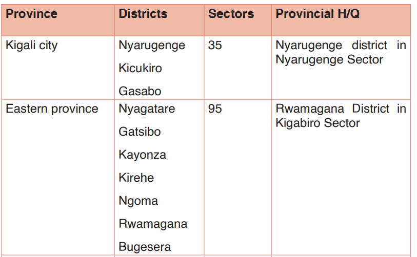
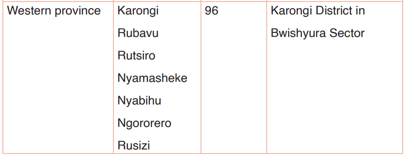

Each of the provinces is headed by a governor. The districts are headed by mayors and the sectors are headed by the executive secretaries.
3.1.2. The relief regions of Rwanda
In Geography, the term relief may be defined as “the variations in elevation and slope of an area of the Earth’s surface”. Example, when someone is talking of an area as being flat, gently sloping or mountainous, specifically he/she is speaking of the relief of that area.
As you know, the surface of the Rwanda is not flat. Some places are high and some places are low. That’s why Rwanda is known as a “ country of thousand hills”. it is largely mountainous with altitude varying between 900 m (Bugarama plain, the lowest place) and 4507m (the top of Karisimbi volcano, the highest point). The Rwandan relief is characterized by high altitude, which decreases towards the western and eastern extremities.
Rwanda is divided into 6 physiographic regions namely:
• The Congo-Nile Crest
• The central plateau
• The Eastern plateau
• The volcanic region (Birunga)
• The rift valley
• The Bugarama plain
Major relief regions of Rwanda
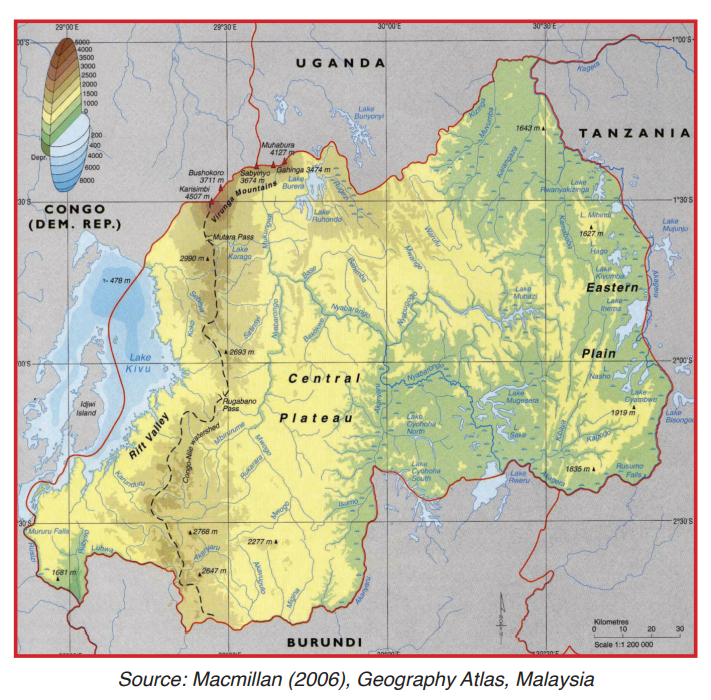
The relief regions of Rwanda are described as follows:
1. The Congo-Nile crest
The term “crest” is defined as a long, narrow, elevated section of the earth’s surface, such as a chain of hills or mountains or the divide between adjacent valleys.
The Congo-Nile crest is a highland that divide between the waters of river Congo to the west and waters of river Nile to the East.It is an extensive area of about 160 km in length (from north to south)and 20 to 50km wide.
It is found in one part of Nyamagabe, Karongi, Rutsiro and Nyabihu districts and all the Ngororero and Nyaruguru districts.
It lies between altitude of 1200m (pass or col of Rugabano) in Karongi, the lowest point and 3000 m found at mount Muhungwe in Nyabihu District which is the highest point non-volcanic above the sea level.
2. The central plateau
The central plateau is also known as high plateau and it is higher in Northern Province where it is called the highland of Buberuka with altitude between 2000 and 2500m (e.g. in Gicumbi and Burera). This region moves from the Eastern slope of the Congo Nile Crest up to the border of Kigali. This means that it covers areas such as Kamonyi, Muhanga, Nyanza, Ruhango, Huye, Gisagara, Rulindo, and Gicumbi. In this region, the landscape is characterized by flat topped hills that are separated from each other by a wide range of river valleys.
It lies between altitudes 1500 to 2500m above the sea level and it covers more than half of the country (over 80 km wide).
3. The eastern plateau
This relief region neighbours the central plateau extending in all the eastern province of Rwanda up to Uganda and Tanzania frontiers. The eastern plateau is also called low plateau.
The lowland areas found in this part are largely dominated by marshes, rivers and lakes. Several small hills with flat and elongated tops with gentle slopes are also the main distinct features in this region. The region has an altitude varying between 1000 and 1500 m above the sea level.
4. The volcanic region or the Birunga region
The volcanic region as suggested by its name, it is associated with the presence of volcanic ranges, hence the name volcanic region. This region covers about 90 kilometres from north to west including the highland areas in the north in Gicumbi district. This region is found in the North West of Rwanda and lies between 3000 to 4507 m above the sea level.
This region extends in Eastern part of DRC and South West of Uganda. This creates a beautiful scenery chain of volcanoes. Some volcanoes are still active; others are dormant while others are in extinct state. Below are the major volcanoes in Rwanda:
a) Karisimbi (4507m) is classified as a complex volcano and the highest of all volcanoes in Rwanda. It has a crater lake of about 120 m in diameter. It usually has crystals that resemble shells hence the name Karisimbi which means white shell.
b) Bushokoro/Bisoke (3711m) is a complex volcanic cone. Due to its past volcanic activity, it is classified as dormant volcano and it has the biggest Crater Lake among volcanoes in Rwanda. Bisoke and Karisimbi are volcanoes which are found in the boundary between Rwanda and DRC.
c) Sabyinyo (3634m) Sabyinyo presents at the top necks of resistant rocks that resemble teeth hence the name Sabyinyo due to its slopes and crater have been badly eroded by surface run off and streams. Sabyinyo is the oldest and most extinct of all the volcanoes in Rwanda. It lies on the border between Uganda, DRC and Rwanda. It doesn’t have any crater lake. The slopes of Mount Sabyinyo are habitat to the endangered mountain gorillas.
d) Gahinga (3474 m) this volcano lies between Muhabura and Sabyinyo. It is one of the smallest and the dormant volcano in Rwanda and estimated to be the smallest in the Virunga chain. This volcanic mountain is situated on the border of Rwanda and Uganda. It is known that at the peak there is a swampy caldera measuring about 180 meters wide. It has got a small crater lake.
e) Muhabura, standing at 4,127 m above sea level makes it the second highest mountain in all five mountains of Birunga mountain ranges behind Karisimbi Mountain. The Muhabura is the most visible volcano throughout the whole of Rwanda especially when the sky is clear. This volcano is the youngest of all the volcanoes in Rwanda. It is a dormant and has a crater lake of about 100 m in diameter. It is found on the border between Rwanda and Uganda.
5. The rift valley region
A rift valley is a linear shaped lowland between several highlands or mountain ranges created by the action of a geological fault. Rift valley is found in the west and south western part of Rwanda. It contains Lake Kivu, the biggest Lake of Rwanda. The depression /rift valley or graben is practically surrounded by the highland with the steep slopes.
The rift valley lies between 1460m and 3000m of altitude.
6. The plain of Bugarama
It is the lowest and hottest area of the country lying on altitude of 900 m above sea level. This plain is made up of sedimentary rocks located in the extreme south west of Rwanda. This means that this plain exists on the old alluvial deposits of sedimentary rocks laid down by sediments from river Rusizi and its tributaries like river Rubyiro.
Application activity 3.1
1. Explain how landlockedness of Rwanda affect its economic development.
2. Using your skills and knowledge, draw a sketch map of Rwanda and locate the following districts: Muhanga, Rwamagana, Nyagatare, Rusizi and Kirehe.
3.2. Problems related to the relief features of Rwanda and their importance
Learning activity 3. 2
1. Identify problems associated with relief features in Rwanda.
2. Explain the importance of relief features in Rwanda
3.2.1. Problems related to the relief features of Rwanda
Despite their importance, the relief features of Rwanda also pose the following problems.
• Faulted landscapes may hinder transport and communication due to steep nature of the landscape.
• Where high mountains are found, it is difficult to practice agriculture
• Faulting causes volcanic eruptions which are destructive.
• Vulcanicity may cause violent earthquakes.
• Vulcanicity encourages soil erosion due to high and steep slopes that are formed.
• The leeward sides of the mountains formed receive very little rainfall.
• Building roads, electricity lines, data cable and coming up with different forms of infrastructure on sloping land is expensive.
3.2.2. Importance of the relief features to the development of Rwanda
• The plateaus and basins formed by folding have facilitated growth of crops; human settlements and the construction of transport and communication networks.
• Landforms features such as the belt of Congo-Nile crest and other highlands modify the climate of the surrounding areas especially through orographic rainfall.
• Formation of lakes and swamps in synclinal valleys has facilitated fishing and sand harvesting.
• Folding leads to the formation of hills which are tourist attraction site. Tourists contribute to the economy by bringing in foreign exchange that supports other sectors of the economy.
• Folded highlands and plateaus have led to a multiplication of space of various socio-economic activities in Rwanda.
• Landforms due to faulting such as rift valleys and others are important sceneries which attract tourists.
• Features such as Lake Kivu act as sources of water for river Rusizi. Rift Valley Lakes provide water for domestic as well as industrial uses.
• Escarpments and fault scarps along rivers such as River Rusizi are important features for the generation of hydroelectric power.
• The rift valley shoulders can help in the formation of relief rainfall.
• Volcanic landscapes like the volcanoes in the Northern Province provide beautiful sceneries that attract tourists who bring in foreign exchange to the country.
• Volcanic landforms like the lava plateaus break down giving rise to fertile volcanic soils that are suitable for plant growth. • Volcanic mountains modify the climate of the surrounding areas through formation of rainfall.
• Lava from volcanic eruptions blocked the flow of rivers leading to the formation of lava dammed lakes such as Lake Burera and Ruhondo.
• Volcanic landscapes are associated with minerals such as Wolfram, Tungsten and Tin.
Application activity 3.2
1. Explain how Rwandans can benefit from volcanic features.
2. Describe the relationship between human activities and relief features.
Skills lab
With reference to the relief features where you live, prepare an appropriate economic activity you can do.
End unit assessment
1. Explain how highland areas influence climate modification in Rwanda.
2. Rwanda occupies a strategic location in East- central Africa, but it is a landlocked country. Suggest what Rwanda can do to overcome the situation.
3. Examine the ways by which farmers could control soil erosion on sloppy areas.