Topic area:
Physical Geography
Sub-topic area:
Drainage
Key unit competence By the end of this unit, you should be able
to describe the drainage system of Rwanda
and explain its relationship to human
activities.
Unit objectives
By the end of this unit, you should be able
to:
• Describe the drainage system of
Rwanda.
• List major rivers, lakes and swamps in
Rwanda.
• Describe the relationship between
drainage and human activities in
Rwanda.
Drainage system in Rwanda
Activity 8.1
1. Name three sources of water in
Rwanda.
2. State where the rain water that is not
tapped by humans goes to.
3. Name three examples of water bodies
that are found in Rwanda.
4 Discuss the importance of the water
bodies that are found in Rwanda.
5. Using information from the internet
and other geographical documents,
describe the drainage of Rwanda
The term
drainage refers to the distribution
of water on the surface of the Earth. Surface
water in Rwanda is distributed in rivers,
lakes and wetlands such as swamps.
Drainage systems are patterns formed by
the streams, rivers and lakes in a particular
drainage basin. The drainage pattern is
determined by the topography of the land,
types of rocks on the land and the gradient
of the land.
A
drainage basin is an area of land drained
by a river and its tributaries. A river and its
tributaries are referred to as a river system.
A river system includes water found in the
water table and surface run-off. There is an
imaginary line separating
drainage basins
called a
watershed. Usually, this is a ridge
of high land.
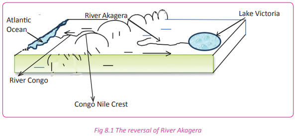
The formation of the majority of Rwanda’s
rivers is traced far back during the earth
movements. Before the major mountains
and the rift valley were formed, many rivers
in Rwanda took the northern and western
directions of flow. They flowed through the
Democratic Republic of Congo on to the
Atlantic Ocean.
When volcanic mountains and the Rift
Valley were formed, the previous basins
were destroyed. This destruction ended
up forming two big river basins that were
formed due to river reversal there were:
(a) Congo basin
(b) Nile basin
A river reversal refers to the change of a
river’s direction of flow due to an obstacle.
For example, River Akagera used to flow
through the DRC emptying its water into
the Atlantic Ocean. However, after the
uplift of the Congo Nile Crest, it changed
its direction eastward and began flowing
towards the Lake Victoria basin in the central part of Uganda where there was
down warping, hence getting a new mouth
at Lake Victoria.
River Akagera reversed and started pouring
water into Lake Victoria basin.
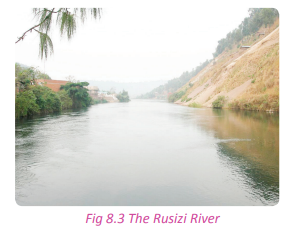
The Congo basin consists of short rivers that
flow into Lake Kivu. The lake has River Rusizi
as its outlet as it flows into Lake Tanganyika.
The Nile basin covers most of Rwanda. It has
rivers that originate from the Congo-Nile
ridge. Rivers Akanyaru and Nyabarongo flow
eastwards and join to form River Akagera
which flows into Lake Victoria in Central
Uganda where the Nile River begins from.
 Major rivers, lakes and swamps in
Rwanda
Major rivers, lakes and swamps in
Rwanda
Activity 8.2
Work in groups of three.
1. Giving examples, differentiate between
the following water bodies;
(i) Rivers
(ii) Lakes
(iii)Swamps
2. Write down your findings and present
them in a class discussion.
Rwanda’s drainage consists of rivers, lakes
and swamps.
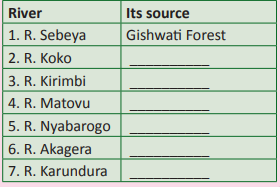
(a) Major rivers
They include;
(i) River Nyabarongo and its tributaries
(Mwogo,Mbirurume, Nyabugogo,
Satinsyi, Base, Akanyaru, Rukarara and
Mukungwa.)
(ii) River Akagera with its tributaries
(Ruvubu, Muvumba, Kibaya and
Kagogo.)
(iii) River Pfunda
(iv) River Sebeya
(v) River Koko
(vi) River Karundura
(vii) River Rusizi and its tributaries (Ruhwa
and Rubyiro)
 (b) Major lakes
 They include;
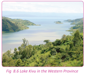
(i) Lake Kivu in the Western Province.
(ii) Lakes Burera and Ruhondo in the
Northern Province.
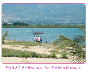
(iii)Lakes Muhazi, Mugesera, Sake, Rweru,
Cyohoha, Ihema, Nasho and Hago in
the Eastern Province.
 (c) Major swamps
They include;
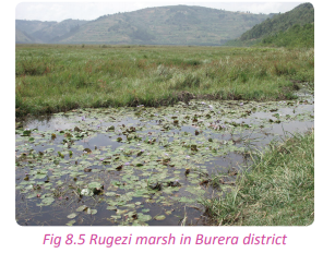
(i) Rugezi in Burera district.
(ii) Kamiranzovu in Nyungwe Forest.
(iii) Along Rivers Akagera, Akanyaru and
Nyabarongo.
 Task 8.1
1. Define;
(a) Drainage
(b) Drainage basin
.
2. Mention the main:
(a) Lakes
(b) Rivers
(c) Swamps of Rwanda.
Major rivers of Rwanda and
drainage basins
Activity 8.3
Work in pairs.
Use the Internet and your knowledge from
the local environment.
1. Find out the major water bodies of
Rwanda.
2. Write down your findings and present
them in a class presentation.
Activity 8.4
Work in pairs.
Study the table below and fill in the missing
information.
As earlier discussed, there are two drainage
basins in Rwanda. The drainage basins are
discussed in association with the river basin
they occupy
(a) Congo basin
The rivers found in this river basin are those
whose direction of flow was changed by the
Earth’s movements. They started pouring
into Lake Kivu. They include rivers listed in
the following table.
 (b) Nile basin
This covers a larger area than the Congo
basin. It starts from the eastern part of the
Congo Nile Crest, extending towards the
Eastern part of Rwanda.
Rivers that are found within this basin
include the following.
(i) River Nyabarongo and its tributaries
which include:
• The Rukarara River
• The Mbirurume River
• The Kiryango River
• Satinsyi River
River Nyabarongo captured River Mukungwa
and changed its direction to the south. As
it flows to the south, other rivers join it as
tributaries. They include:
• River Base
• River Bakokwe
• River Nyabugogo
• River Akanyaru
(ii) River Akagera which has its source
from Lake Rweru. It is one of the
longest rivers of Rwanda. It has several
tributaries which include the following:
• River Kibaya
• River Kagogo
• River Ruvubu (From Burundi)
• River Karangazi
• River Muvumba
Activity 8.5 1. Draw a drainage sketch map of Rwanda.
2. Pin it up on the classroom notice board
for assessment.
The major lakes and their mode
of formation
Activity 8.6
Do this in pairs.
1. Draw a sketch map of Rwanda and on
it, locate the lakes found in the country.
2. Classify the major lakes of Rwanda
according to their mode of formation.
3. Write down your explanations and
present them in a class discussion.
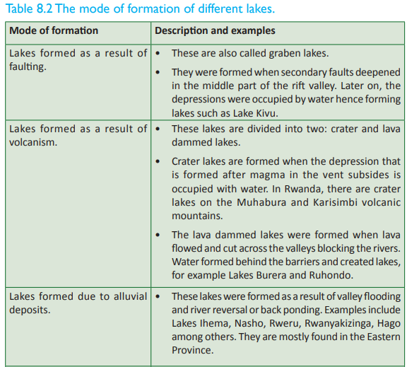
Rwanda has different types of lakes which
are classified according to their formation.
They include the following:
(a) Rift valley lakes
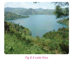
Lake Kivu located in the Western Province
of Rwanda. This was formed as a result of
faulting, therefore it is called a
graben lake.
 (b) Volcanic lakes
Lake
(b) Volcanic lakes
Lake Burera and Lake Ruhondo, situated
in the Northern Province of Rwanda.
These two lakes were formed as a result of lava damming that blocked the rivers
which originated from the Rugezi marshy
area. The damming led to back ponding of
water hence the formation of the two lava
dammed lakes.
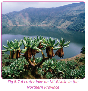
There are also crater lakes on the volcanoes
of Rwanda. They are on Muhabura,
Karisimbi, Gahinga and Bisoke.
(c) Alluvial deposition lakes
Lakes of Akagera and Bugesera which
include the following:
(i) Bilira (Ox bow lake)
(ii) Hago (Ox bow lake)
(iii) Ihema
(iv) Mihindi
(v) Nasho
(vi) Rwampanga
(vii) Rwanyakizinga
(viii) Rweru
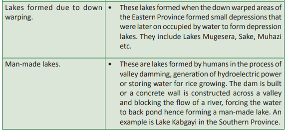
 (d) Depression lakes/downwarped
These lakes are found in the Eastern
Province. They include the following:
(i) Sake
(ii) Muhazi
(iii) Mugesera

(e) Man-made lakes
These lakes are not common in Rwanda.
However, a few of them have been created.
They include the following:
(i) Lake Rwagitima
(ii) Lake Kabgayi located near the town of
Muhanga along Huye road
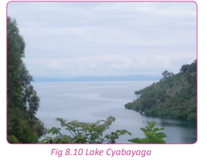
(iii) Lake Cyabayaga in Nyagatare
 Mode of formation
Activity 8.7 Work in pairs.
Use the Internet and other geographical
documents;
1. Using the knowledge acquired on the
drainage of Rwanda, explain the mode
of formation of the following lakes;
(i) Lake Kivu
(ii) Lake Burera
(iii) Lake Mugesera
(iv) Lake Cyabayaga
2. Write down your explanations and
discuss them in a class presentation.
The Rwandan lakes were formed in different
ways. Below is a detailed description of how
lakes were formed.
 Task 8.2
1. Describe the major drainage basins of
Rwanda.
2. Giving examples, discuss the mode of
formation of the main lakes in Rwanda.
Major wetlands in Rwanda
Activity 8.8
Work in pairs.
1. Giving examples, identify the main
wetlands in Rwanda.
2. Write down your findings and present
them in a class discussion.
A wetland is an area that is either
permanently or seasonally saturated with
water. Such areas are always wet with large
volumes of stagnant water. In Rwanda,
wetlands are protected areas.
The major swamps of Rwanda are divided
into two categories. They are:
(a) The valley or low altitude swamps.
These include:
• Swamps of Nyabarongo
• Swamps of Akanyaru Valley
• Swamps of Akagera
(b) High altitude swamps which include the
following:
• Kamiranzovu swamp
• Rugezi swamp
• Pfunda swamp
(c) Other wetlands and swamps of Rwanda
include the following:
• Mutobo
• Gishoma
• Mwogo
• Base
• Nyabugogo
• Rwasave
• Sake
• Ngenda
• Ntende
• Bugarama
• Muganza
• Mugonero
• Koko

The importance of wetlands to
the development of Rwanda
Activity 8.9
In groups, use geographical information,
personal experience, other academic
resources.
1. Find out the importance of wetlands to
human activities.
2. Discuss the value of wetlands to
the socio-economic development of
Rwanda.
3. Write down your findings for a class
presentation.
Wetlands are important to the development
of the country as well as to human activities.
Some of the importances of wetlands
include the following:
(a) They are a source of water
Wetlands are sources of water for both
domestic and industrial purposes.
(b) Natural water purification system Wetlands play a role in filtering water
naturally. They trap and absorb toxins,
sediments and dirt from water. This
purification avails fresh water that reaches
the lakes and rivers of Rwanda.
(c) Fishing activities
Wetlands support fishing activities by
providing suitable breeding and feeding
grounds for fish. They also offer refuge to
the young fish. They are therefore important
sources of fish. The swamps of Bugesera
in the Eastern Province provide suitable
breeding places for tilapia and cat fish.
(d) Homeland for flora and fauna
There is a wide variety of biodiversity in
wetland areas. These are important in the
development and promotion of tourism
in the country. For example, the Akagera
swamps where there are different bird
species, various swamp vegetation and
animals such as hippos, crocodiles, varans
and snakes.
(e) Source of raw materials
Wetlands are rich in materials that are used
in the production of art and craft products.
These raw materials include papyrus, palms
and other swamp vegetation. They are used
in weaving.
(f) Provision of clay
These areas have been and are still areas
where good clay can be found. Clay is used
in pottery, ceramics and brick making. A
good example is the establishment of Ruliba
factory that entirely depends on clay got
from Nyabarongo swamp.
(g) Source of food
Swamps in Rwanda support the growth
of specific types of crops. These have
enhanced food security in the country. The
crops grown in wetlands are water tolerant
and require highly saturated soils. They
include; yams along Nyabugogo swamp, rice
at Muhanga in the valley of Rugeramigozi
River and Cyabayaga in Eastern Province.
 Grazing areas
There are plants that grow near or within
the wetlands that are used as pasture for
domestic animals such as goats, sheep
and cattle. The plants include sedges and
different types of grasses. The wetlands
provide a secure alternative grazing land
during the dry seasons.
(i) Modification of climate Wetlands play a great role in the hydrological
cycle which is the main component in the
modification of climate. They contribute
to the formation of convectional rainfall,
hence influencing the micro-climate of the
surrounding areas.
(j) Source of medicine
The wetlands of Rwanda have swamp
vegetation, some of which are medicinal.
These include the roots of Mondia whitei
and Phoenix reclinata which are used in
treatment of various diseases.
(k) Reduction of the occurrence of
floods Wetlands trap sediments which would
otherwise find their way to river channels,
narrowing the carrying capacity of rivers causing floods. They also store much water
that would otherwise increase the water
volume in rivers and lakes and causing floods.
(l) Recreational resource
Wetlands provide good sites for peaceful
relaxation and walks. Some of them support
hunting and fishing sports that attract
tourists who bring foreign exchange to the
country.
(m)Sanctuary for birds
Wetlands are homelands to a wide variety
of bird species in Rwanda. This explains why
Akagera and Bugesera areas have many
birds and host birding activities.These areas
are tourist attraction sites.
Wetland destruction
Activity 8.10
Study the extract below and answer the
questions that follow.
“Enormous pressure, over the recent years,
has been exerted on the water and wetland
resources through various emerging and
increasing uses driven by the growing
population. Some of these threats include
agricultural intensification, pollution,
invasive species, overuse and inadequate
institutional frameworks to manage the
wetlands. Some of these threats, in the case
of water, have affected both the quantity
and quality of water available. Climate
change is also contributing to degradation
of swamps. With decreasing amounts of
rainfall, the hydrological regime of wetlands
is being threatened”.
Source:
Rwanda state of environment and
outlook report.
1. Explain the meaning of wetland
destruction.
2. Identify the causes of wetland
destruction mentioned in the extract
above.
3. Find out other causes of wetland
destruction in Rwanda that have not
been mention in (2) above.
4. Write down your findings and present
them in a class discussion.
There is clear evidence that shows wetlands
in Rwanda are being destroyed. Their
existence is being threatened either through
the need for land for development or need
for land for agricultural projects. Some of
the causes of wetland destruction in the
country include the following.
(a) Need for more land for agricultural
activities There is shortage of land in Rwanda. This
has created pressure on the wetlands that
are now being reclaimed to grow rice and
other crops such as yams and beans.
(b) Pollution
Water pollution has become a serious threat
to the wetlands in Rwanda. Both domestic
and industrial wastes are secretly or
sometimes openly dumped into the wetland
areas. The wastes destroy the natural state
of the wetlands. The most affected area is
the Nyabugogo swamp in Kigali.
(c) High demand for wetland resources
There is over exploitation of resources
found in wetland areas such as alluvial sand
that is needed in the construction. The
swamp vegetation is also endangered due
to increased demand for
Cyperus papyrus and Cyperus denudatus that are needed in
wearing making and Vossia cuspidata that
is used in roofing.
(d) Water reservoirs
The government through the Rwanda
Agricultural Board (RAB) , has encouraged
the creation of water dams where water is
reserved for irrigation purposes. This cuts
down on the natural water supply to the
wetlands. There are also many irrigation
schemes that have been established that all
depend on water from the wetlands.
(e) Development and construction
There are many construction projects that
have been put up on reclaimed wetlands.
This is evidenced in Nyabugogo where
houses are being set up on wetland areas
and in the Gikondo industrial area which
was established on a wetland.
(f) Fire outbreaks
There are many occurrences of fire outbreaks
in swampy areas. This degrades the wetlands
where the burnt vegetation dwells. When
this happens, both vegetation and animals
that depend on wetlands are destroyed.
(g) Weeds and aquatic animals
There are water weeds in wetlands that
never existed in Rwanda before. The weeds
now compete with the swamp vegetation
and may eventually replace the indigenous
vegetation. The most serious weed affecting
wetlands is the water hyacinth. The affected
areas are the Rweru swamps.
Straightening and dredging of rivers
This has drained more water from wetlands
leaving behind less saturated areas. This
has led to drying up of swamp vegetation.
The regular
dredging of River Nyabugogo
is responsible for the extinction of some
plant species.
(i) Climatic changes
Global warming has affected the wetlands
which have drastically decreased in size due
to the reduction in water supply.
(j) Urbanisation
The growth and development of towns and
cities in Rwanda is associated with increased
housing demands. The construction
activities have reduced the infiltration of
run-off. The run-off that carries wastes
dumps them into the wetlands affecting
their natural state.
Measures to promote the
sustainable use of wetlands
Case study
Work in groups of five.
Miss Mumararungu Yvone, a resident of
Huye wanted to establish a fruit processing
company in her home area. When she went
to the Rwanda Development Board (RDB)
offices to seek authorisation, she was asked
to present an environmental assessment
report. Unfortunately, she did not have
one. She was then sent to the Rwanda
Environment Management Authority
(REMA) offices to seek help from there.
When she got REMA, an environmental
assessment team was sent to do an
environmental impact assessment on the
proposed project. The team found that the
industry would affect the wetland where
she wanted to establish it. The report they gave did not allow RDB to give her any
authorisation document. She was advised
to look for another place in Bugesera where
the land is dry.
(a) Give reasons why you think the RDB
denied Miss Mumararungu permission
to set up her fruit processing plant.
(b) Discuss why it is important for the
RDB to regulate the establishment
of industries and other development
projects on wetlands?
(c) Explain the importance of the
environmental impact assessment
study that was carried out by REMA
on the environment and on securing
wetland areas.
(d) Describe other measures that the
Rwandan Government and population
can put in place to conserve the
wetlands.
(e) Prepare a campaign on sustainable
utilisation of wetlands around your
school and sensitise the local population
about it.
(f) Discuss your findings and answers in a
class discussion.
Owing to the importance of wetlands, it
is important for the country and the local
populations to develop positive values and
attitudes towards proper management,
conservation and protection of wetlands.
Below are some of the ways that can be
used to conserve wetlands so as to enable
proper and sustainable utilisation of the
areas.
(a) The people should be made aware
of the need to conserve and protect
the wetlands. The population should
be educated on the importance of wetlands to the environment and to
them. These can be done through
the use of mass media, posters,
brochures and local village meetings.
The local leaders and environmental
officers should educate the people on
the importance of wetlands, proper
management and utilisation.
(b) The government agencies involved
in the conservation and protection
of wetlands such as REMA should
conduct research studies. This will
come up with workable solutions
on the proper use, conservation and
management of wetlands.
(c) New guidelines on the proper use,
conservation and management of
wetlands should be formulated to
guide the local populations.
(d) The government through parliament
should enact new laws that deal with
wetlands. In this way, it becomes a
criminal offence to destroy or misuse
the wetlands.
(e) There should be compulsory eviction
of people who have settled on
wetland areas or those who use the
wetlands without authorisation from
the relevant authorities.
(f) More effort should be put in preventing
fire outbreaks that have continued to
destroy vast areas of wetlands. The
people should be made aware that it
is destructive to burn the wetlands in
favour of agricultural or any other uses.
(g) A wetland protection task force
should be established to ensure close
monitoring of the uses of wetlands.
Proper disposal of wastes should be
deviced in order to avoid dumping of
dangerous wastes into wetlands.
Task 8.3
1. Name three wetlands in Rwanda.
2. Discuss the importance of wetlands in
the development of Rwanda.
3. (a) Discuss three causes of wetland
destructions in Rwanda.
(b) Suggest measures to promote the
sustainable use of wetlands.
Relationships between the
drainage system and the human
activities
Activity 8.11 Work in groups.
Using the internet and other geographical
sources of information such as personal
experiences and the local environment;
1. Find out the relationship between
drainage systems and the local
environment.
2. Relate your findings to the human
activities that take place in the area
near your school or home.
3. Write down and present your findings
in class.
The relationship between the drainage
system and the human activities in Rwanda
exists as follows:
(a) The drainage system in the country
facilitates irrigation farming which
supports the growth of crops making
the country food secure.
(b) The country’s drainage favours water
transport that eases the movement
of goods and people from areas of
abundance to places of scarcity.
(c) Hydroelectric power is generated
using water from rivers such as River
Nyabarongo. Power is a vital necessity
in the execution of human activities
such as industrialisation and mining.
(d) The drainage system in the country
has contributed to the development
of tourism. For example, tourists go to
River Akagera to view its pronounced
meanders.
(e) The drainage system offers habitats
for aquatic animals such as fish
which is used as food. This favours
the development of fishing as an
economic activity.
(f) Rivers as part of the country’s drainage
system are associated with precious
minerals such as diamonds and gold.
This favours mining.
(g) Clay is also associated with the rivers.
The clay is used by ceramic industries.
The drainage system in the country
modifies the climate in the country. It
enables the formation of rainfall that
supports agricultural activities.
(i) The drainage system in the country
is associated with the development
of swamps. Swamps have vegetation
that are used in art and craft which is
a source of income to people staying
near them.
Activity 8.12
Work in pairs.
1. Explain how the distribution of water
bodies affects human activities and
population distribution in Rwanda.
2. Discuss the importance of water bodies
in determining and developing different
human activities.
3. Write an essay on your findings
and present it to your teacher for
assessment.
Did you know?
• The country’s hydrological network
includes numerous lakes and rivers and
its associated wetlands.
• In Rwanda, the abundance of water
resources is reflected by the existence
of a network of wetlands in various parts
of the country.
• The drainage of Rwanda is mainly
influenced by rainfall and evaporation.
• Drainage and water resources have a
direct influence on the quality of life of
the people, their health and their overall
productivity.
• Drainage supports human activities such
as agriculture, industrial development,
hydropower generation, transport,
socio-economic development and
poverty eradication.
End of unit revision task
1. (a) Define the river basin.
(b) Giving examples, describe the
drainage systems of Rwanda.
2. (a) List four rivers of Rwanda and state
their sources.
(b) Examine the importance of rivers
and lakes to the socio-economic
development of Rwanda.
3. The drainage system is at the centre
of economic development of Rwanda.
Discuss.
4. (a) Analyse the causes of wetland
destruction in Rwanda.
(b) Explain the measures put in place
to ensure sustainable utilisation of
wetlands in Rwanda.
5. “Drainage systems and human activities
are inseparable.” Discuss.
6. To what extent are man’s activities
influenced by drainage systems in Rwanda?