General
- Geography S4 SB File Uploaded 25/01/22, 10:39
- S4 : Geography TG File Uploaded 11/08/22, 22:37
UNIT 3:Formation of relief features in Rwanda
Topic area: Physical Geography
Sub-topic area: Landform evolution and processes
Key unit objective
By the end of this unit, you should be able to investigate the formation of major relief regions of Rwanda and evaluate their effects on human activities.
Unit objectives
By the end of the unit, you should be able to:
• Locate Rwanda in Africa.
• State the area of Rwanda in terms of land and water surface area.
• Describe the population composition and administrative divisions of Rwanda.
• Locate major relief regions of Rwanda.
• Identify the major relief features of Rwanda using a map.
• Outline the endogenic processes leading to the formation of different relief features of Rwanda.
• Give the importance of relief features of Rwanda.
• Identify the problems related to the relief features of Rwanda.
• Outline the exogenic processes leading to the formation of different relief features of Rwanda.
General representation of Rwanda
Location of Rwanda in Africa
Activity 3.1
Use the map of Africa provided on page 57 to answer the questions that follow.
1. Use the map reading skills that you have acquired in your previous studies.
(a) Locate the position of Rwanda.
(b) State the latitudinal and longitudinal location of Rwanda.
2. Name the countries that neighbour Rwanda by completing Table 3.1 on page 58.

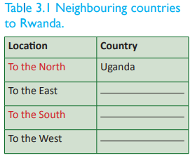
Rwanda is a sovereign landlocked state in East-Central Africa. It lies between latitudes 1°04’ and 2°51’ South of the equator and longitudes 28°53’ and 30°53’ East of the Greenwich Meridian. Rwanda is bordered by Uganda to the North, Tanzania to the East, The Democratic Republic of Congo to the West and Burundi to the South. Rwanda lies within the African Great Lakes Region. It is a highly elevated country. Its landscape is dominated by mountains in the West and plains savanna to the East. It has numerous lakes throughout the country. The climate of the country is temperate to subtropical, with two rainy seasons and two dry seasons each year.
The size of Rwanda
Activity 3.2
Do this in pairs. Use the Internet and your atlas to do the following.
1. Find out the size of Rwanda in terms of:
(a) total surface area
(b) land surface area
(c) water surface area.
2. Compare the size of Rwanda with other countries within the region, in Africa and internationally. (Kenya, DRC and Switzerland).
Rwanda is one of the smallest countries in Africa. It has an area of 26,338 sq km. It extends 248 km NE – SW and 166 km SE – NW. It has a total boundary length of 893 km. Its land surface is 24,668 sq km while its water surface is 1,670 sq km. Comparatively, Rwanda is 86 times smaller than the Democratic Republic of Congo, 35 times smaller than Nigeria, 90 times smaller than Algeria and 323 times smaller than Brazil. Globally, Rwanda is slightly smaller than the state of Maryland in the United States of America (USA). These comparisons clearly show how small the country is.
Activity 3.3
Do this in pairs.
Rwanda is widely known as the land of a thousand hills.
1. Discuss how Rwanda’s landscape is of benefit to the country.
2. State the advantages Rwanda has owing to its geographical location.
3. Rwanda is a landlocked country. Discuss the impact of this to the economy of the country.
4. Write down your findings and discuss them in a class presentation.
Administrative divisions of Rwanda
Activity 3.4

Rwanda has been an independent Republic since 1st July 1962. The country is governed by the Constitution that was adopted by a referendum on 26th May 2003. The constitution was then published in the official Gazette of the Republic of Rwanda on 4th June 2003. Kigali city is the capital city of Rwanda. It is located near the centre of the country.
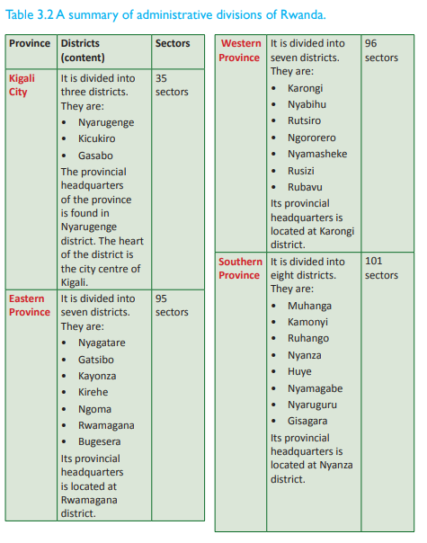
The country is divided into 5 administrative divisions known as provinces. There are 4 provinces named after their geographical positioning, that is Northern Province, Eastern Province, Southern Province Western Province. Kigali City is the fifth administrative division.
These provinces are further portioned into 30 districts. The districts are then narrowed down to 416 sectors. Each of the provinces is headed by a governor. The districts are headed by mayors and the sectors are headed by the executive secretaries.

Activity 3.5
1. Draw a sketch map of Rwanda.
2. On it, locate the administrative divisions.
3. Put your map on your class notice board.
The population of Rwanda
Activity 3.6
Do this in pairs. Use the Internet, Geography textbooks and journals to find out the following.
1. The population size of Rwanda.
2. The population composition of Rwanda.
3. The standards of living and its relationship to the life expectancy.
4. Write down your findings and present them in a class discussion.

According to the population census in 2012, the population of Rwanda was 11,457,801 persons. The population density of Rwanda as of August 2012 was 450 persons per square kilometre. This is among the highest population densities in Sub-Saharan Africa. According to the CIA World Factbook, Rwanda’s population composition as of 2014 was as follows;
• The male population comprised 48.2% of the total population.
• The female population comprised 51.8% of the total population.
• 42.1% of the population was below the age of 15.
• 18.9% was between 15 – 24 years.
• 32.5% was between 25 – 54 years.
• 4% was between 55 – 64 years.
• 2.5% was over 65 years.
• Life expectancy at birth in Rwanda was estimated to be at 64 years in 2013.
Standard of living
Activity 3.7
Do this in pairs.
Study the photographs provided below and answer the questions that follow.
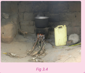

Rwanda has been credited worldwide for her efforts to improve and uplift the standards of living of the majority of its people. Majority of the Rwandan citizens have been living in extreme poverty for decades. Rwanda is a rural country where 90% of the total population finds its livelihood from subsistence agriculture. This encourages a hand-tomouth lifestyle where people have very little to save. This situation has lowered the income levels of the people. Most of them survive on less than a dollar a day.
The country is naturally disadvantaged with few resources, in particular minerals. The minerals occur in small quantities making it uneconomically viable to engage in massive commercial exploitation. However, the country has a rich ecosystem. The high population levels have imposed great pressure on land and created an increased demand for agricultural products. This has resulted in shortage of food especially in the countryside areas. The Rwandan economy is still agrarian, largely supported by the earnings from the export of coffee and tea, after tourism.
The government has made it a policy to make sure that people are assisted. Many families are given cows, water and electricity. This is meant to improve the living standards of the people. Despite this, there is still much needed to be done to economically empower the masses.
Activity 3.8
Project work
Use the Internet and journals that show statistics on the demographics of Rwanda.
1. Find out the population sizes in the different provinces in the country.
2. Compare the population sizes of the different provinces in relation to the resources and living standards of the people.
3. Discuss how the population composition of Rwanda is of benefit to the country.
4. Suggest ways in which Rwanda as a country can maintain a healthy population and safe environment. Begin from the cells, sectors, district, province and finally to the national government.
5. Write a report on your findings.
6. Make a class presentation on your findings.
7. Your teacher will assist you to compile and present your report to your local leaders for implementation.
The relief regions of Rwanda
Activity 3.9
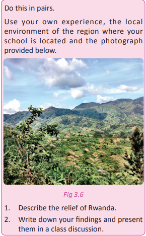
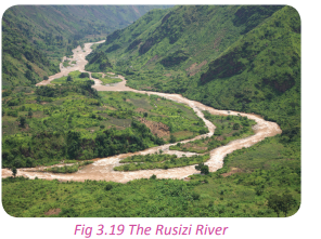
The landscape of Rwanda is not homogenous. It is dominantly described by the rolling hills and mountainous appearances. The altitude decreases from West to East. The highest point on the land of Rwanda is situated on a volcanic mountain known as Mt. Karisimbi at an altitude of 4507 metres above sea level. The lowest point is found in the area drained by River Rusizi at 900 metres above sea level. The rising and falling relief has enriched the topography of the country. It is against this beautiful scenery that the country of Rwanda is referred to as ‘the land of a thousand hills.
The upcountry areas of Rwanda are characterised by grasslands and relatively small sized farmlands that occupy the slopes of the rolling hills. The divide between Congo and the Nile drainage system cuts across North to South. It partly extends to the western region at an average elevation of about 2720 kilometres. To the western sides of this ridge line, the relief dips towards Lake Kivu and the Rusizi river valley. This provides a natural boundary between DRC and Rwanda. The altitude of the western slopes is gentle, described by low rolling hills including the highlands of the central region. It gradually drops in elevation resulting to the formation of lowlands that are dominated by swamps and lakes.
Climate
Activity 3.10
Work in pairs.
1. Define the term climate
2. Describe the climate of the area where you come from.
3. Describe the general climate of Rwanda.
4. Record and discuss your findings and use them in a class discussion.
The climate of Rwanda is not truly equatorial in spite of the country being located only 2° South of the equator. The climate is greatly influenced by the hilly and mountainous landscape making the relief of the country the main determining factor. The relief has modified the climate to a temperate tropical highland climate. It has lower temperatures than those typical for equatorial countries due to its high elevation. The climate of Rwanda is defined by two rainy seasons; February to May and September to December. Other months form dry seasons. During the rainy seasons, heavy downpours occur almost daily, alternating with sunny weather. The annual rainfall averages 800 millimetres and is generally heavier in the western and northwestern mountains than in the eastern savannas. Rainfall ranges from about 900 millimetres in the east and southeast to 1500 millimetres in the north and northwest volcanic highland areas. The Northern rainfall is heavier due to the orographic rainfall received. This is influenced by the mountains and highlands that have dense vegetation.
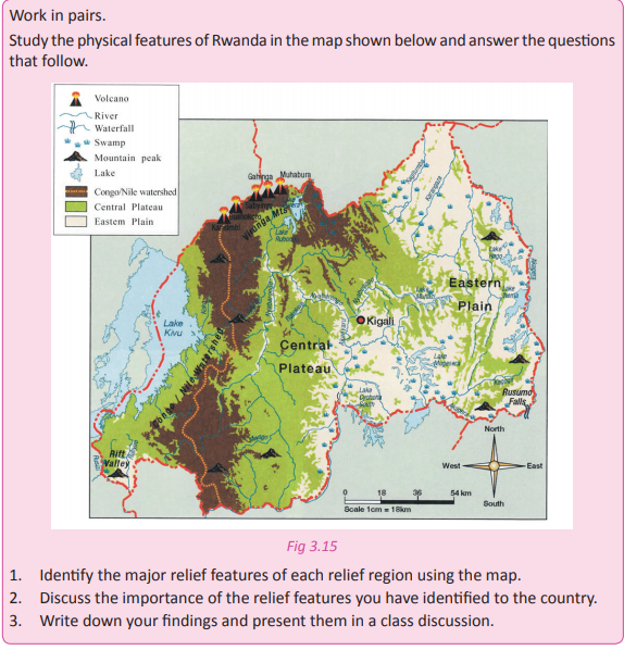
Relief regions of Rwanda
Activity 3.11
In groups, using geographical documents such as textbooks, internet and the environment, research on the relief regions of Rwanda. Use your findings to answer the following questions.
1. Explain the meaning of relief.
2. Name and describe the main relief regions of Rwanda.
3. Draw a sketch map of Rwanda to locate the physical regions of Rwanda.
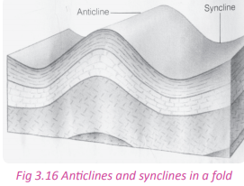
The term relief refers to the nature of the landscape or the topographical set up of an area. There are six relief regions in Rwanda. They include; the Eastern plain, the central plateau, the volcanic region, the highland areas, the Congo-Nile Crest/watershed, the rift valley and the Rusizi region (Bugarama plains). To the north and west of the country, the relief is at a high elevation. steadily drops towards the Eastern parts of the country. The locations of the above outlined relief regions of Rwanda are illustrated below.

The tectonic movements are greatly responsible for the shaping of the relief of Rwanda as it is the case with other East African regions. The relief regions of Rwanda as described as follows.
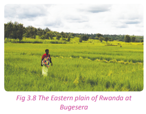
(a) The Eastern plain
This relief region neighbours the central plateau extending from Akanyaru-Kigalieast/Gicumbi to Tanzania. Areas that are part of this region include Bugesera and Umutara. The lowland areas found in this part possess marshy areas, rivers and lakes. They include Lakes Cyohoha, Lake Sake, Lake Mugesera, Lake Muhazi and others. Rivers include River Akagera, River Nyabarongo and their tributaries. The altitude of this area is between 1000 and 1500 metres above sea level. It is made up of plateaus that are put apart from each other.
(b) The Central plateau
This physiographic region begins from the Southern part of the Northern Province moving towards Burundi. It also moves from the Eastern slope of the Congo Nile Crest up to the border of Kigali. In this region, the landscape is characterised by flat topped hills that are separated from each other by a wide range of river valleys. These river valleys are rich in alluvial deposits.
This region cover areas such as Muhanga, Ruhango, Nyanza, Bugesera, Huye, Gisagara and Kigali. The average elevation of this relief region ranges between 1500 and 2000 metres high. This area dominates a wide area of the country. It is from this region that Rwanda is referred to as the land of thousand hills.
(c) The volcanic region
Activity 3.12
Work in pairs. Study the photographs provided below and answer the questions that follow.
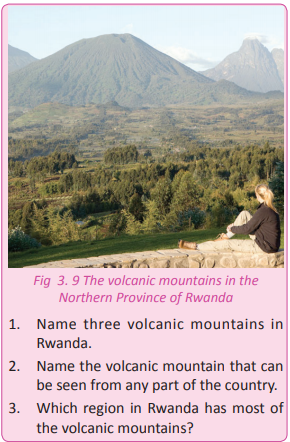
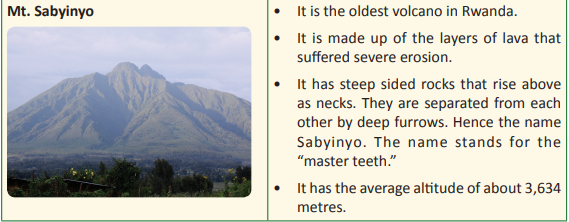
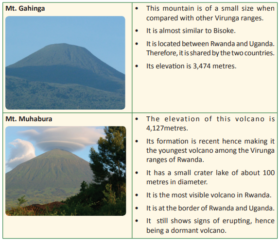
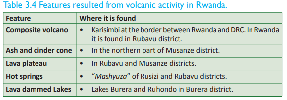
This is the relief region of Rwanda that is associated with the presence of volcanic ranges, hence the name volcanic region. Locally, the region is known as the Birunga region. This region covers about 90 kilometres from north to west including the highland areas in the north in Gicumbi district. Volcanic activity shaped the landscape of this area, completely setting up its distinct features. The table below shows the volcanoes that are associated with relief region.

The Rwanda volcanoes are connected to other volcanic ranges that are located in the DRC such as Mikeno, Nyiragongo, Nyamuragira and Murara. However, Nyiragongo, Murara and Nyamuragira are classified as active volcanoes.
Task 3.1
1. Explain the meaning of elevation as used in physical geography.
2. Name any 2 physical regions of Rwanda.
3. List four volcanic mountains that are part of the relief of Rwanda.
4. Examine the advantages of such mountains mentioned in 3. above.
(d) Congo - Nile Crest /watershed
This is described by the highlands of the Western part that compose the divide of River Nile and River Congo. The length of this relief region is approximately 160 kilometres from North to South. It has a width of between 20 to 50 kilometres. In this region, the highest elevation point is found at Mt. Muhungwe which is 3000 metres above sea level. However, the average altitude is 2500 metres above sea level.

(e) The Rift Valley
The western bloc of the Great Rift valley that forms the East African Rift Valley passes through Rwanda. It is edged by some of the highest mountains in the region. This includes the Birunga Mountain ranges. Much of the Rift Valley lies within the boundaries of the Volcano ranges. The formation of the Rift Valley is responsible for the creation of the mountains, valleys and lakes found in the country just like it is in the other East African countries.
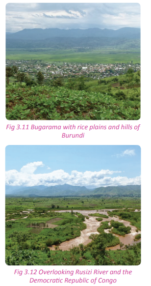
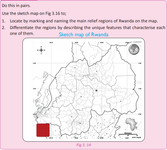
(f) Rusizi region (Bugarama plains)
This is the lowest region in Rwanda. It is also the hottest part of the country. It is located to the southwest of the country close to the border with Burundi and the Democratic Republic of Congo. It is an extension of Imbo plain in Burundi. Its elevation is 900 metres above sea level. This region is drained by River Rusizi. The lowlands of the southwest in Bugarama plain are part of the tectonic depression of the African Rift Valley.
(g) Slopes and borders of Lake Kivu This relief region is located along the shores of Lake Kivu. The average altitude ranges between 1460 and 3000 metres above sea level. The landscape of this area was greatly formed by tectonic forces. The region has steep escarpments that have been severely eroded.

Rwanda is gifted with relief features that have beautifully decorated the appearance of the landscape. The landscape of Rwanda was caused by various geomorphologic processes the greatest one being tectonic forces.
Activity 3.12
Activity 3.13
Activity 3.14
Your teacher will organise for you to go on a fieldwork tour to one of the relief regions of the country. Follow the preparation steps that you learnt in Unit 1 to prepare for the tour. In groups of five, do the following
1. Study and record the relief features of the areas where you pass.
2. Carefully observe and record the relief features of the region that you have visited. 3. Draw a sketch map of Rwanda and locate the major relief features of the country on it. 4. Write a report and present your findings in a class presentation.
Task 3.2
1. Define the term relief.
2. Describe the relief regions of Rwanda.
3. Name at least four volcanoes found in Rwanda.
4. Name three volcanoes that are active and located outside Rwanda.
5. In which relief region is the lowest land or part of Rwanda found?
The geomorphologic processes associated with the Rwandan landscape
Activity 3.15
Work in pairs. Use the geography knowledge that you have gained from the previous classes.
1. Name some of the processes responsible for the formation of the relief features of Rwanda.
2. Discuss the processes giving examples of relief features in the country.
3. Present your findings in a class discussion.
Geomorphology refers to the study that deals with the origin and evolution of various landforms. It studies land forms that are found on Earth and on the sea beds. Geomorphologic processes refer to the processes that lead to the formation or creation of the various landforms and relief features. There are two processes that are responsible for the formation of relief features in Rwanda. They include: the endogenic and exogenic processes.
Endogenic processes These are processes whose operation begins from the interior of the Earth.
These internal processes include folding, faulting, vulcanicity, and warping.
(a) Folding
Activity 3.16
Use a plain paper to do the following. Write the findings of your observation for a class discussion.
1. Hold the piece of paper from both sides.
2. Push the paper uniformly towards the centre using the same force from all sides.
3. Make sure that the shape of the paper changes into ‘ups and downs’.
4. Write down the findings.
Folding refers to the bending of crustal rocks of the Earth’s crust after being subjected to compressional forces within the interior of the Earth. Folding takes place on young rocks of sedimentary deposits. Folding may take place slowly over several years resulting to the formation of monoclines, synclines and anticlines. Synclines are plains or basins while anticlines are hills or mountains.
This process played a great role in shaping the landscape of a large part of Rwanda. The features formed by folding are prominent in the Eastern and Central flat topped hilly areas. Folding leads to the creation of physical features such as: fold mountains, escarpments, plateaus, basins and cuestas. Examples of fold mountains in Africa include the Atlas Mountains, which stretch from Morocco to Algeria and Tunisia and the Cape ranges.

(b) Faulting
This refers to the cracking or breaking up of rocks of the Earth’s crust. The cracking is caused by tectonic forces of compression and tension that are active within the Earth’s crust. Faulting can result in mountain building. The movements of the plates within the Earth’s crust can cause rocks to break and be displaced. The cracks on the crustal rocks can result into structural changes within the Earth’s crust. Each side of the crack or fracture is known as a fault while the place where the fault occurs is referred to as the fault plane. There are different types of faults. They include the normal fault, reverse fault tear fault, and the thrust fault.

Faulting is responsible for the formation of land forms found in the Western region of Rwanda. Physical features found in this part of the country such as the Congo-Nile crest and the western arm of the rift valley are a result of faulting. In Rwanda, faulting further led to occurrence of fault guided rivers such as Rusizi, Mwongo, Rukarara, and Nyabarongo rivers that flow through fault guided valleys. Graben lakes such as Lake Kivu were created by faulting. The faults scarps and escarpments found in Rwanda all form evidence of the effects of faulting. The young and new fault lines in the caves of Musanze are also evidence that faulting is still active in Rwanda.
(c) Vulcanicity
Activity 3.17

1. Name the process that is taking place here.
2. Name two relief features found in Rwanda where such a process occurred.
3. Analyse the importance of the features on the environment of Rwanda.
4. Discuss your findings in class.
This is a process through which hot semi solid, gaseous and liquid materials called molten lava erupt from the interior parts of the Earth (the mantle). The materials pass through fault lines which are lines of weaknesses and reach the Earth’s surface. When they cool, they lead to the formation of physical features.

This process shaped and reshaped the landscape of the northwestern parts of Rwanda especially Musanze region and its neighbouring areas. The western region of the country also has various physical features that were created as result of vulcanicity. Examples are found in Rubavu and Rusizi districts.
The table below shows a summary of the landforms formed by volcanic action.
(d) Warping
This is the sinking or rising of crustal layers of rocks. Warping occurs as a result of vulcanicity, faulting and folding processes that act upon the land mass. In most cases, lateral compressional forces push the crustal layers leading to up warping or down warping. For example, warping led to the formation of down warped areas such as those in Kirehe, Bugesera, Ngoma, and Kayonza. Some parts of these areas were filled up with water and formed down warped lakes such as Lakes Mugesera and Muhazi. On the other hand, some parts of western region up warped creating raised areas that interfered with the flow of rivers. Some of the rivers had to change their direction of flow. For example River Akagera changed direction and started pouring its water into Lake Victoria. Other reversed rivers are the Nyabarongo and Mukungwa Rivers.
Activity 3.18
Work in pairs.
Use the Internet, Geography textbooks and other Geographical materials;
1. With the aid of diagrams, find out the mode of formation of the different relief features of Rwanda.
2. Describe the processes of formation of the different features.
3. Write down your findings.
4. Present your findings in a class discussion.
Importance of the relief features to the development of Rwanda
Activity 3.19 Work in groups of three.
1. List down the different relief features of Rwanda and the processes responsible for the formation of each one of them.
2. Categorise the features according to their processes of formation.
3. Find out the importance of the different relief features that you have mentioned to the development of the country.
4. Discuss their importance relating them to their processes of formation.
5. Note down your findings and present your findings in a class discussion.
Activity 3.19
Work in groups of three.
The relief features of Rwanda have the following importance.
1. The plateaus and basins formed by folding have enabled the growth of crops, human settlement and the construction of transport and communication networks.
2. The highlands formed by folding have influenced the climate of the areas where they are found especially rainfall formation.
3. The formation of lakes in valleys has encouraged fishing and sand harvesting.
4. Folding leads to the formation of hills which are tourist attraction sites. Tourists contribute to the economy of the country by bringing in foreign exchange that supports other sectors of the economy.
5. Landforms formed through faulting like the Great Rift Valley are important tourist attraction sites.
6. Features such as Lake Kivu act as a source of water for River Rusizi. The many rivers and lakes in the country provide water for domestic and industrial uses.
7. The escarpments and fault scarps along rivers e.g. River Rusizi are important for the generation of hydro electric power.
8. Volcanic landforms like the lava plateaus break down giving rise to fertile volcanic soils that are suitable for plant growth.
9. Volcanic landscapes like the volcanoes in the Northern Province provide beautiful sceneries that attract tourists who bring in foreign exchange to the country.
10. Volcanic mountains modify the climate of the surrounding areas through formation of rainfall.
11. Lava from volcanic eruptions block the flow of rivers leading to the formation of lava dammed lakes such as Lakes Burera and Ruhondo. The lakes provide water for use and can be used for fishing and transport.
12. Volcanic landscapes are associated with minerals such as Wolfram, Tungsten and Tin.
Activity 3.20
this in pairs.
Use the Internet, Geography textbooks, journals and fieldwork experience.
1. Examine ways in which the relief features of Rwanda vary.
2. Give reasons for the variation of the relief throughout the country.
3. Note down your findings to be presented in a class discussion.
Problems related to the relief features of Rwanda
Activity3.21
Work in groups.
1. Find out the problems related to the relief features of Rwanda.
2. Discuss them and write down your findings.
3. Present them in a class discussion.
Despite their importance, the relief features of Rwanda also pose the following problems.
1. Faulting discourages transport. The features formed such as the rift valley are barriers to transport and communication.
2. Where high mountains are formed, it is difficult to practice agriculture.
3. Faulting causes volcanic eruptions which are destructive. The molten lava destroys farmland, leads to loss of lives of humans and animals and affects settlements. For example, in the year 2002, the volcanic eruption at Goma left many people homeless.
4. Vulcanicity may cause violent earthquakes. For example, in 2002, houses were destroyed in Rubavu by earthquakes when Mt. Nyiragongo erupted.
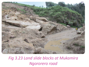
5. The earthquakes are sometimes responsible for landslides which are destructive to life and property.
6. Vulcanicity encourages soil erosion due to the high and steep slopes that are formed.
7. The leeward sides of the mountains formed receive very little rainfall.
Task 3.3
1. Define endogenic processes.
2. Explain the following processes and state the examples of landforms associated with each one of them. (a) Vulcanicity
(b) Folding
(c) Faulting
3. Study the following table and fill in the missing information.
Exogenic processes
Activity 3.22
Exogenic processes are processes that take place on the surface of the Earth. The forces that are responsible for the exogenic processes are commonly referred to as denudation forces. They include the following:
• Weathering
• Erosion
Weathering and the resultant features
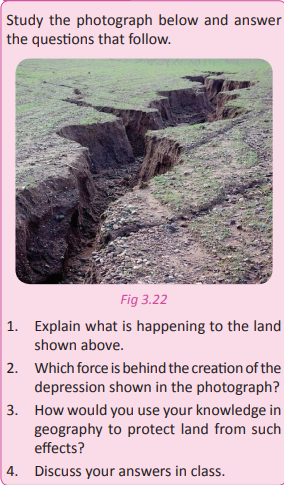
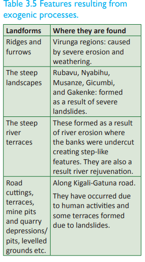
Weathering is the breaking down or dissolving of rocks and minerals on Earth’s surface. Water, ice, acids, salt, plants, animals, and changes in temperature are all agents of weathering. There are chemical, biological and mechanical weathering processes executed by the various agents. Once the rocks have been broken down, the bits of rocks are transported to various places by erosion. There is active weathering, erosion and mass wasting mostly in form of landslides in the mountainous areas of Rwanda. This occurs mostly in the western and northern regions.
In highland areas like in Gicumbi, southern and the central parts of Rwanda, mass wasting occurs during the rainy season. This occurs along the steep slopes. This has left most of the slopes bare with scattered scars. Weathering causes ridges and furrows, depressions, caves, springs, underground water channels and karsts. Furrows and depressions caused by weathering are found in the Birunga region in Rwanda.
Activity 3.23
Using resource persons, Geography textbooks and journals. In groups of four do the following:
1. Find out the areas in your country that have been affected by weathering and soil erosion.
2. Your teacher will organise for you to visit some of these areas.
3. Observe the features in the area.
4. Find out the causes and effects of weathering in the area.
5. Write a report on your observations and findings.
6. Present them in a class discussion.
Erosion and deposition by running water
Activity 3.24
1. Discuss the causes and effects of soil erosion in the area near your home or school.
2. Suggest measures that should be taken to minimise soil erosion and its effects.
3. Show how these measures can be applied to minimise soil erosion and its effects in all the regions of the country.
4. Present your findings in a class discussion.
Heavy rains on sloppy and mountainous areas cause erosion. The soils on the slopes of the hills are washed away by surface runoff causing thinning of soils. This makes the land agriculturally unproductive. Constant and continuous erosion in some of the areas form new features. The soils that are carried away by the surface run-off are deposited in flat plains and plateaus. This is the reason why there are fertile plateaus in some areas. Other agents of erosion are wind and waves.
In areas of Rwanda where rainfall is unreliable, wind erosion and physical weathering have affected the landscape. This has been sped up by animal keeping, high temperatures due to prolonged dry seasons, poor farming methods and construction.

River erosion and deposition
Activity 3. 25
Work in pairs. Use the Internet and Geography textbooks for your research.
1. Study one major river in Rwanda.
2. Find out the erosion features on its course.
3. Find out the deposition features on its course.
4. Note down your findings and share them in a class discussion
Rivers usually flow from upland to lowland areas. Along their course, they carry soil and other materials that they deposit at the end of their course. River erosion and deposition are responsible for the formation of fertile areas especially where alluvial soils are deposited. Examples of features formed by river erosion include waterfalls, gorges, spurs, rapids, canyons, potholes, ridges and valleys e.t.c. The ridges and valleys in the western part of the country are as a result of river erosion. Those formed by river deposition include: floodplains, alluvial fans, oxbow lakes, natural levees, deferred tributaries, meanders, braided channels, deltas etc. An example of a river depositional feature is the Nyabugogo flood plain in Kigali City.

Activity3.26
Work in groups.
Use the Internet, Geography textbooks and journals.
1. Find out how the process of weathering and erosion occur in detail.
2. Write notes about the processes.
3. Make a class presentation on your findings
Wave erosion and deposition
Activity 3.27
Use the Internet and Geographical materials to find out the following.
1. The meaning of wave erosion.
2. How wave erosion occurs.
3. How wave deposition occurs.
4. Note down your findings.
5. Discuss your findings and share them in a class discussion.
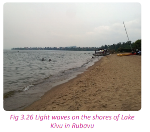
A wave is a long body of water curling into an arched form and breaking on the shore. Wave erosion occurs when the energy and pressure of waves combines with the chemical composition of water to erode rock and sand. Wave erosion is also known as coastal erosion. It not only occurs in oceans, but also in other large bodies of water. Some of the features of wave erosion include: wave cut platforms, archs, headlands and bays, cliffs, caves, stacks etc. Features of wave deposition include barrier islands, spits and beaches, marshes and mudflats, bay bar, sand dunes, rias, reefs, fiords etc.
Mines and quarries
Activity 3.28
1. Study one known quarry in Rwanda.
2. Find out how the quarry has contributed to the creation of relief features in the area where it is located. 3. Note down your findings and present them in a class discussion.
Human activities such as mining, road construction and other infrastructural development and poor methods of farming have accelerated weathering and erosion. When open cast mining is used, the land is subjected to weathering and erosion. Open depressions are left behind. These change the look of the environment. Examples of areas where human activities have affected the landscape include parts of: Kayonza, Gicumbi, Muhanga, Nyamagabe and Rubavu. The features formed as a result of such activities include, depressions and cliffs. Weathering has also left many rocky places prone to exogenic forces. Some of these features are found along Musanze – Kigali road.

The table below shows the features that have resulted out of exogenic processes
In summary, the relief of Rwanda has been a result of endogenic processes that created volcanoes and its associated features. However, the role played by exogenic processes cannot be overlooked. They have continued acting upon the already existing landforms resulting into new landforms.
Effects of weathering and erosion on relief features of Rwanda
Activity 3.29
Work in pairs.
Using the Internet, Geography textbooks and journals.
1. Discuss erosion and the weathering processes.
2. Analyse the effects of the two processes on the relief features of Rwanda.
3. Write down your points and present them in a class discussion
(a) Erosion is responsible for the creation of hills and valleys. It removes sediments from areas that were once glaciated and transports materials down slope from elevated sites. Along the way, valleys are created. Accumulation of these materials at their destination over time creates small hills.
(b) Erosion shapes the shorelines of lakes and coastlines e.g astride Lake Kivu.
(c) Gradual weathering and erosion are also responsible for the creation of new physical features from the previously existing ones. For example erosion of spurs on rivers forms bluffs.
(d) Continuous erosion can also lead to the complete destruction of some of existing physical features.
(e) Wave erosion creates new features of the coastal region.
(f) Weathering and erosion distort the general appearance of the relief of the country
Activity 3.30
Project work. Work in groups of five. Use the Internet, Geography textbooks, journals and fieldwork experience to collect data for this research.
1. The effects of running water, river erosion and deposition, wave erosion and deposition and mines and quarries on the relief features of Rwanda.
2. Write a report on your findings that you will present in class
Activity 3.31
Work in pairs. Using the knowledge and evidence gained on the effects of weathering and erosion on the relief of Rwanda;
1. Find out how this has impacted on the population distribution in the country.
2. Write an essay of your findings.
Did you know?
• Rwanda is a landlocked country in EastCentral Africa with an area of 26,338 sq km.
• Rwanda has a high population and is among the countries with the highest population density in Sub-Saharan Africa.
• The prevalence of HIV/AIDS has had a significant impact on the population of Rwanda.
• Rwanda lies on the Great East African plateau, with the divide between the water systems of the Nile and Congo rivers passing in a north-south direction through the western part of the country.
• Almost all of Rwanda is at least 1,000 metres above sea level.
• The high altitude of Rwanda provides the country with a pleasant tropical highland climate.
End of unit revision task
1. With the help of a sketch map of Rwanda;
(a) State the location of Rwanda using latitudes and longitudes.
(b) Name the neighbouring countries of Rwanda.
(c) Examine the benefits Rwanda enjoys because of her neighbours.
2. Rwanda is a landlocked country.
(a) Define the term landlocked.
b) Analyse the challenges Rwanda faces as a result of its landlocked state.
(c) Giving specific examples, show how the government of Rwanda has addressed the challenges mentioned in (b) above.
3. (a) Give a brief description of the relief of Rwanda.
(b) Show how the relief of Rwanda has influenced human activities and the economic development of the country.
4. (a) With the help of a sketch map of Rwanda, name and indicate the relief regions of Rwanda.
(b) Show how any of the two relief regions identified in (a) above has affected the environment.
5. Write short notes on the following:
(a) Exogenic processes
(b) Endogenic processes
(c) Denudation processes
(d) Differentiate between weathering and erosion.
6. Using specific examples, analyse the geomorphologic processes associated with Rwanda’s relief features.
7. Relief is not a single factor that has influenced the climate of Rwanda. Discuss.
8. To what extent is vulcanicity responsible for the shaping of the landscape of Rwanda?
9. Determine the difference between folding and faulting in relation to the Rwandan Geography.
10. (a) Analyse the importance of the relief features of Rwanda to the development of the country.
(b) Discuss the problems associated with the relief features of Rwanda.