General
- Geography S5 SB File Uploaded 28/01/22, 13:38
- S5 : Geography TG File Uploaded 19/08/22, 10:37
UNIT 8: WEATHER AND CLIMATE OF THE WORLD
Key unit competence:
By the end of this unit, I should be able to appreciate the importance of the
atmosphere, weather and the impact of climate on the environment and human
activities in the world.
Introductory activity:
Read the following passage and answer the questions that follow: The climate is defined as the average weather conditions of an area in terms of temperature, atmospheric pressure, wind direction and wind speed, moisture, cloudiness, precipitation, and sunshine for a standard period of 30 years. Due to its high altitude, Rwanda enjoys a tropical temperate climate. The average annual temperature ranges between 16 and 20° C, without significant variations. Rainfall is abundant although it has some irregularities. Winds are blowing with a speed of 1-3 m/s. With an economy that is dominantly supported by agriculture.
1. Referring to the passage above distinguish climate from weather.
2. Identify the relationship between weather, climate and atmosphere on
earth’s surface.
3. Examine the influence of climate on the environment and socioeconomic development of Rwanda.
8.1. The atmosphere

8.1.1. Meaning of the atmosphere
The atmosphere is the envelope of gases surrounding the earth. It contains the gases that support all forms of life on earth. This envelope of air is dense at the sea level. It thins out with increase in altitude.
8.1.2. The structure of the atmosphere
The atmosphere is a mixture of various gases surrounding the earth. It provides all gases that are essential for sustaining all life forms on the earth. Based on temperature variation, the atmosphere is made up of four layers: the troposphere, the stratosphere, the mesosphere and the thermosphere. On the basis of chemical composition; the atmosphere is composed of two layers: the homosphere and the heterosphere.
Thermal characteristics of atmosphere
The atmosphere is made up of four vertical layers. These are: troposphere, stratosphere, mesosphere and thermosphere.
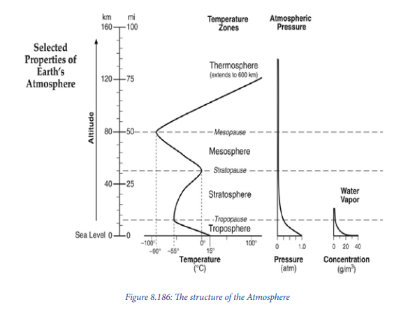
Troposphere
Climatically, the troposphere is the most important because all the elements of weather and weather phenomena occur in this layer (e.g. evaporation, condensation, and precipitation of different forms like fog, cloud, dew, frost, rainfall, snowfall, thunder, lightning, atmosphere storms, etc.). This layer contains about 75% of gaseous mass of the atmosphere, most of water vapour, aerosols and pollutants.
It is characterized by the following:
– It is the lowest layer of the atmosphere.
– The upper limit of the troposphere is called the tropopause.
– The temperature decreases with altitude at the rate of 6.5°C per km or
3.6°F/1000ft.
– The atmospheric pressure decreases also with altitude and reaches to
100 millibars and 250 millibars over the equator and poles respectively at
tropopause.
– It lies between 10 km and 20 km above the sea level.
– All weather phenomena occur in this layer. These are evaporation, condensation
and precipitation. Condensation is the conversion of vapour or gas into a liquid
of different forms. Precipitation is water that falls to the ground as rainfall,
snow or hail.
– The height of tropopause is 17 km over Equator and 9 to 10 km over the poles.
Stratosphere:
The stratosphere is the layer which is extending from 16 to 50 km above the sea level.
It is characterized by the following:
– There is increase of temperature due to absorption of ultraviolet solar radiation
by ozone layer and lesser density of air.
– There is nearly absence of weather phenomena because of dry air and rare
occurrence of clouds.
– The lower portion of the stratosphere having maximum concentration of ozone
is called ozonosphere, which is confined between the heights of 15 to 35 km
from sea level. Depletion of ozone would result in the rise of temperature of the
ground surface and lower atmosphere. The main causes of ozone destruction
are halogenated gases called chlorofluorocarbons (CFCs: chlorine, fluorine
and carbon). This results to global warming, acid rain, melting of continental
glaciers and rise in sea level, skin cancer, poisonous smoke, decrease in
photosynthesis, ecological disaster and ecosystem instability.
– The upper limit of the stratosphere is known as stratopause.
Mesosphere
– The mesosphere extends between 50 km and 80 km.
– Temperature decreases as height increases. In fact, the rise of temperature
with increasing height in the stratosphere stops at the stratopause.
– At the uppermost limit of the mesosphere (80 km), the temperature drops at
-80° C and may go down as low as - 100° C to -133° Celsius at mesopause.
– This layer is characterized by very low air pressure ranging between 1.0
millibar at 50 km altitude representing stratopause, and 0.01 millibars at the
mesopause (between 90 and 100 km).
Thermosphere
It extends from 80 km to 640 km. It is composed of Ionosphere and Exosphere.
Thermosphere
It extends from 80 km to 640 km. It is composed of Ionosphere and Exosphere.
The ionosphere consists of the following ionized layers:
– D layer: reflects low-frequency radio waves but absorbs medium and highfrequency waves. Being closely associated with solar radiation, it disappears
as soon as the sun sets.
– E layer: The E-layer is also called the Kennelly-Heaviside layer. It reflects the
medium and high-frequency radio waves. It is much better defined than the D
layer. It is produced by ultraviolet photons from the sun rays interacting with
nitrogen molecular. This layer also does not exist at night.
– Sporadic E-layer: This layer occurs ttunder special circumstances. It is believed
that this sporadic layer is caused by meteors and by the same processes that
cause aurora lights. This layer reflects very high frequency radio waves.
– E2 layer is generally found at the height of 150 km and is produced due to the
reaction of ultra-violet solar photons with oxygen molecules. This layer also
disappears during the night times.
– F layer consists of two sub-layers e.g. F1 and F2 layers (150 km-380 km) are
collectively called the Appleton layer. These layers reflect medium and high
frequency radio waves back to the earth.
– G layer (400 km and above) most probably persists day and night but is not
detectable.
The exosphere represents the uppermost layer of the atmosphere. The density becomes extremely low. The temperature reaches 5568° C at its outer limit, but this temperature is entirely different from the air temperature of the earth’s surface as it is never felt. The atmosphere above the ionosphere is called the outer atmosphere and it is made of exosphere and the magnetosphere.
8.1.3. Composition of atmosphere
Basically, the atmosphere is composed of three major constituents, namely: gases, water vapour, and aerosols.
a. Gases
The main gases are shown in the table below:
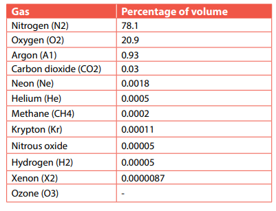
The following are the most important gases:
1. Nitrogen, which is about 78.1% of the total gases. Nitrogen is for all life forms. It is an important part of amino acids which make up proteins. Nitrogen (N) is one of the building blocks of life: it is essential for all plants and animals to survive. Nitrogen (N2) makes up almost 78.1% of our atmosphere. Humans and most other species on earth require nitrogen in a “fixed,” reactive form.
Life depends on nitrogen, which is a basic ingredient in amino acids that make up all proteins. While a substantial percentage of the atmosphere is comprised of nitrogen gas, it must be processed into a soluble form. This is done via a nitrogen cycle that occurs in the soil. Then plants and the animals that eat them can obtain dietary nitrogen.
Plants with nitrogen deficiencies look weak. Their leaves, which should be healthy and green, may look wilted and yellow. Animals and people get dietary nitrogen by eating protein-rich foods like milk, eggs, fish, beef and legumes. Nitrogen, carbon, hydrogen and oxygen are found in amino acids, which are the main structures of every protein.
The nitrogen cycle involves:
– Transfer of atmospheric nitrogen into soils (known as nitrogen fixation);
– Mineralization, nitrification and transfer of nitrogen from soils to plants.
– Denitrification and return of nitrogen to the atmosphere. It helps the
oxygen in combustion; it also helps indirectly in oxidation of some
elements.
2. Oxygen: This makes up 20.9% of gases in the atmosphere. The molecular oxygen (O2) mostly occurs up to the height of 60 km in the lower atmosphere. It is produced through photosynthesis. This is the process by which green plants use sunlight, carbon dioxide and water to make their own food. It is one of the main elements that make up air, and it is necessary for the survival of all plants and animals e.g. animals breathe in oxygen.
3. Carbon dioxide represents 0.03% of the total atmospheric gases. The gaseous carbon (CO2) plays two significant roles:
– Carbon dioxide helps in the process of photosynthesis where carbon, hydrogen, and oxygen are combined by the autotrophic green plants of terrestrial and marine ecosystem. This is assisted by sunlight that enables the formation of the organic compounds.
– Carbon dioxide is transparent to incoming shortwave solar radiation. It is opaque to outgoing long wave terrestrial radiation. It is evident that carbon dioxide is most significant greenhouse gas. The concentration carbon dioxide increases due to the anthropogenic activities, namely the burning of fossil fuels and wood and deforestation which lead to probable climate change through global warming.
4. Ozone (O3): It is defined as “a three-atom isotope of oxygen (O3) or merely a triatomic form of oxygen (O3). It is formed with the separation of (O2). Then, these separated oxygen atoms (O) are combined with Oxygen molecules (O2) and thus ozone (O3) is formed. It is a life-saving gas because it filters the incoming shortwave solar radiation and absorbs ultraviolet rays. Therefore, the ozone layer protects the earth from becoming too hot. It is known as the earth’s umbrella to all organisms in the biospheric ecosystem against their exposure to ultraviolet solar radiation. The highest concentration of ozone is between the altitudes of 12 km and 35km in stratosphere; the said zone is also called ozonosphere.
a. Water vapour: Liquid water turns into vapour through the process of evaporation. The content of water vapour decreases with the altitude in the atmosphere. More than 90% of the water vapour in the atmosphere is found up to a height of 5 km. The moisture content in the atmosphere creates clouds, fogs, rainfall, frost, snowfall and other forms of precipitation.
b. Aerosols: These are suspended solid particles and liquid droplets. These particles are from various sources like volcanic eruptions, desert dust, spores and pollen. The concentration of these particles decreases with increasing altitude in the atmosphere.
8.1.4. Importance of the atmosphere
The atmosphere is important for the following reasons:
– It protects living things from harmful ultraviolet rays of the sun. This role is
played by the ozone layer. The atmosphere serves as a protective shield against
radiation and cosmic rays.
– Dense layers of molecular gases also absorb cosmic rays, gamma rays and
x-rays, preventing these energetic particles from striking living things and
causing mutations and other genetic damage.
– Even during a solar flare, which can greatly increase the damaging output of
the sun, the atmosphere is able to block most of its harmful effects.
– It helps to regulate the heat during the day and night. On earth, however,
molecules in the atmosphere absorb the sun’s energy as it arrives, spreading
that warmth across the planet. The molecules also trap reflected energy from
the surface, preventing the night side of the planet from becoming too cold.
– The Earth’s atmosphere protects and sustains the planet’s inhabitants by
providing warmth and absorbing harmful solar rays.
– The atmosphere traps the sun’s energy and sends off many of the dangers of
space.
– It provides the various gases that are useful to living things. These include
oxygen.
– It provides precipitation that helps to sustain life on earth.
– The atmosphere is made of gases that are essential for photosynthesis and
respiration, among other life activities.
– The atmosphere is a crucial part of the water cycle. It is an important reservoir
for water and the source of precipitation.
– The atmosphere moderates Earth’s temperature because greenhouse gases
absorb heat.
– Atmosphere contains the oxygen and carbon dioxide, which living things
need to survive.
– The atmosphere also serves an important purpose as a medium for the
movement of water. Vapour evaporates out of oceans, condenses as it cools
and falls as rain. Hence, providing life-giving moisture to otherwise dry areas of
the continents. Without an atmosphere, it would simply boil away into space,
or remain frozen in pockets below the surface of the planet.
Application activity 8.1
1. a. Explain why the atmosphere should be conserved. b. Describe how atmosphere should be conserved. 2. Identify the susceptible sources of aerosols in your area.
8.2 Elements of weather and climate

Definition of weather and climate
Weather can be defined as the state of the atmosphere at any given time. This state is about temperature, atmospheric pressure, wind speed and direction, moisture, cloud cover, precipitation, and sunshine. Weather keeps changing all the time. The change is from hour to hour and day to day.
Climate is an average weather conditions over a long period of time (about 30 years). It is measured by assessing the patterns of variation in temperature, humidity, atmospheric pressure, precipitations, wind speed and direction.
The elements of weather and climate: Weather and climate are made up of many elements. The main ones are temperature, precipitation, wind, atmospheric humidity, clouds, sunshine and atmospheric pressure.
8.2.1. Temperature
Learning activity 8.2.1
Read the context below and answer the questions that follow: When people migrate from Bugesera to Musanze they are required to change clothing style. Some of them say that it is necessary to put on jackets due to climatic conditions of that area.
1. Why is there constant change of clothing style from Bugesera to
Musanze?
2. Identify the weather condition that led people to put on jackets in
Musanze while in Bugesera they put on tee-shirts.
3. What may be the possible causes/factors responsible for that constant
change?
Temperature is the degree of heating and cooling of the atmosphere at a given area and time. The sun is the source of heat to the atmosphere.
Factors influencing temperature variation
Temperatures change from place to place. These changes are influenced by the following factors:
Latitude or distance from the Equator: The temperature of a place depends on the amount of sunshine reaching there. The amount of sunshine received decreases as one moves away from the Equator.

Altitude: Temperatures decrease with increasing height from the earth’s surface. This is at the average rate of 6.5°C per 1km or 1000 metres ascent.

Distance from the sea: Places on the coast are affected by land and sea breezes. Therefore, they have low temperature. Places that are far away from the coast have high temperature.
Prevailing winds: Winds blowing from low latitudes to high latitudes raise the temperature of the regions where they reach. Winds blowing from high latitudes to low latitudes lower the temperature.
Nature of land and water: The contrasting nature of land and water surfaces in relation to the incoming shortwave solar radiation largely affects the spatial and temporal distribution of temperature. It may be pointed out that land becomes warm and cold more quickly than the water body. The following reasons explain the differential rate of heating and cooling of land and water.
– The sun’s rays penetrate to a depth of only one meter in land because it is
opaque, but they penetrate to greater depth of several meters in water because
it is transparent to solar radiation.
– Heat is concentrated at a place where the process of redistribution of heat by
conduction is very slow because the land surface is static.
– There is more evaporation from the seas and the Oceans and hence more heat
is spent in this process. This results in oceans getting less insolation than the
land surface. On the other hand, there is less evaporation from the land surface
because of very limited amount of water.
– The reflection (albedo) of incoming solar radiation is more over oceanic water
surface than over land surface and thus water receives less insolation than
land.
– Oceanic areas are generally clouded and hence they receive less insolation
than land surface. But clouds absorb outgoing terrestrial radiation and
counter-radiate heat back to the earth’s surface.
Nature of ground surface: The nature of ground surface in terms of colour, vegetation, and land use practices affects distribution of temperature. Areas under vegetation absorb more heat from the sun than those without vegetation.
Nature of ground slope: The slopes facing the sun receive more heat from the sun because its rays reach the surface more or less straight. These areas have higher temperature than those not facing the sun.
Cloud cover: The amount of cloud cover affects temperature. It is observed that night time temperature during clear sky is much less than clouded nights. Cloudy nights and days are warmer than cloudless nights and days.
Ocean currents: The warm Ocean currents flowing from tropical areas to temperate and cold zones raise the average temperature in the affected areas. For example, the Gulf Stream raises the average temperature of the coastal areas of north-western Europe while Kuroshio warm current raises the temperature of Japanese coasts.
Mountain barriers: Mountains block the movements of air from one place to another. This has an influence on temperature on both sides of the mountain.

Measurement and recording of temperature
The instrument used for recording temperature is called a thermometer. Temperature is measured in degrees:
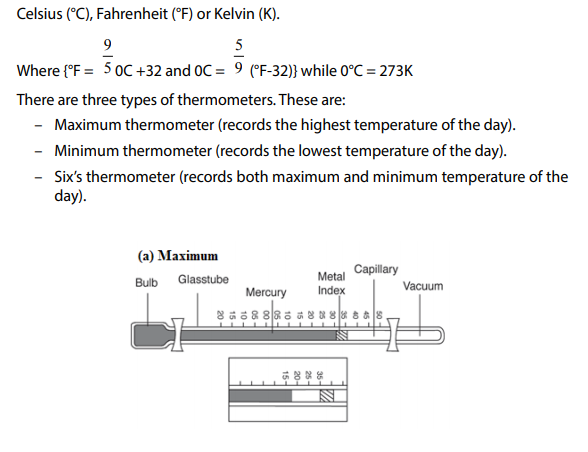
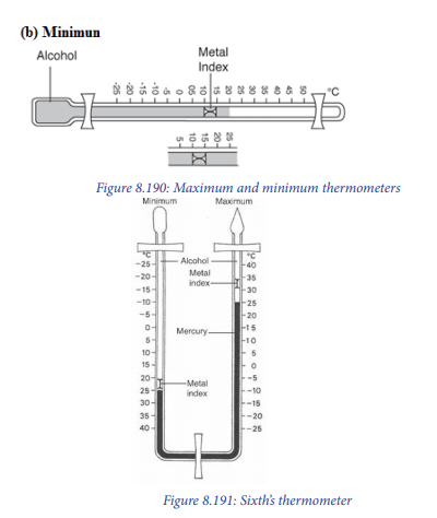
Terms related to temperature
– Mean (average) temperature
The following are types of average temperature:
Diurnal average (the average temperature within 24 hours of the day)

From the table above, the diurnal mean temperature is 18.4°C. This is got by adding the daily temperatures and dividing the total by 24 (hours).
– The highest temperature recorded within 24 hours is called the maximum
daily temperature. It is 22°C (from the above table).
– The lowest temperature recorded within 24 hours is called the minimum daily
temperature. It is 16°C (from the above table).
– Monthly mean temperature: This is the sum of mean daily temperatures for
a given month divided by the number of days of that month.
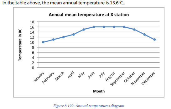
– Annual mean temperature: This is the mean temperature of 12 months of the year.
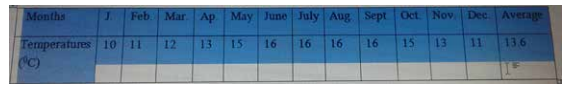
– Temperature range
– The difference between the maximum and minimum temperatures of the day is called daily range of temperature. Therefore, it is 22°C - 16°C = 6°C (from the above table showing the daily temperature variations).
– The difference between the maximum and minimum temperatures of the month is called monthly range of temperature.
– The difference between maximum and minimum temperatures of the year is called annual range of temperature. Therefore, it is16°C - 10°C = 6°C (from the above table showing the annual temperature variations).
– Impact of temperature on the environment
– The following are the major impacts of temperature on the environment:
– A rise in global temperatures could lead to an increase of evapotranspiration. This could eventually lead to the rise in amount of rainfall
which impact on environment positively or negatively.
– A rise of temperature leads to melting of glaciers in polar and mountainous
regions or ice-capped highlands.
– An increase in temperature leads to global warming which impacts
negatively on the environment.
– As the earth gets warmer, plants and animals that need to live in cold
places like on mountain tops or in the Arctic, might not have a suitable
place to live. If the Earth keeps getting warmer up to one fourth; all plants
and animals could become extinct within 100 years.
– Animals are changing migration patterns and plants are changing the
dates of activity.
– The sea level has been rising more quickly over the last century as a result
of temperature change
– Precipitation (rain and snowfall) has increased across the globe; on
average as a result of temperature change.
8.2.2. Precipitation
img here
a. Meaning and forms of precipitation
Precipitation is any form of liquid or solid water particles that fall from the atmosphere and reach the earth surface. The following are main forms of precipitations:
Rainfall is the most widespread and important form of precipitation. It occurs when there is enough moisture in the air that condenses above freezing point. Rain is liquid water, in form of raindrops with diameter of more than 5 mm with 8,000,000 cloud droplets. This is formed of droplets that have condensed from atmospheric water vapour and then becomes heavy enough to fall under gravity. Rain is a major component of the water cycle and is responsible for depositing most of the fresh water on the Earth.
Snow: It is formed when condensation occurs below freezing point (less than 0°C). The fall of snowflakes is called snow-fall. Snowflakes are formed when air temperature is greater than -5°C but less than 0°C. A snowfall is ‘precipitation of white and opaque grains of ice’.
Drizzle: It is defined as the fall of numerous uniform tiny droplets of water having diameter of less than 0.5 mm. Drizzles fall continuously from low status clouds, but the total amount of water received at the ground surface is significant.
Fog: This is a cloud layer lying in contact and very close to the surface of the earth or sea.
Frost: It is defined as transformation of gaseous form of water (water vapour) directly into solid form (the process being called sublimation) at the ground surface, in the soils and in the air, layer just lying over the ground surface due to condensation occurring below freezing point.
Hail: It consists of large pellets or spheres (balls) of ice. Hail is a form of solid precipitation wherein small balls or pieces of ice, known as hailstones, have a diameter of 5 mm to 50 mm. In contrast, ice pellets (sleet; sometimes called small hail) have a diameter less than 5 mm.
Sleet: It refers to mixture of snow and rain.
Ice pellets are snow grains, transparent or translucent grains of ice which are formed when condensation takes place below freezing point. The diameter of ice pellets is up to 5 mm and shape of the pallets is highly irregular depending upon the conditions of condensation.
Dew: These are droplets of water that are deposited on the ground. As the exposed surface cools by radiating its heat, atmospheric moisture condenses at a rate greater than that at which it can evaporate, resulting in the formation of water droplets. When temperatures are low enough, dew takes the form of ice; this form is called frost.
Rime: It is an opaque thin, white layer of ice that forms when the air temperature is below the freezing point of water, especially outside at night.
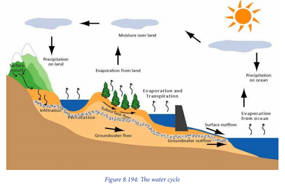
b. The water cycle
The water cycle also known as the hydrological cycle or the hydrologic cycle describes the continuous movement of water on, above and below the surface of the Earth. The water moves from one reservoir to another, such as from river to ocean, or from the Ocean to the atmosphere, by the physical processes of evaporation, condensation, precipitation, infiltration, surface runoff and subsurface flow. In doing so, the water goes through different forms: liquid, solid (ice) and vapour. The following are the main components of water cycle:
– Evaporation of water from Ocean, sea, lakes, rivers, ponds and transpiration from the leaves of plants through insolation (solar energy).
– Conversion of water into water vapour or humidity (first and second phases are almost the same).
– Horizontal transport of atmospheric moisture over the Oceans and the continents by atmospheric circulation (advection).
– Condensation: The transformation of water vapour into solid form. This takes place when the dew point is below freezing point to form snowfall, and when dew point is above freezing point to turn the water vapour into liquid form (i.e. above 0°C temperature of the air), is called condensation.
– Precipitation (either in liquid form as rain water, or in solid form as snow and ice and other minor forms of dew, fogs etc.).
– Runoff and infiltration: Eventual transfer of water received at the earth’s surface to the Oceans via various routes and hydrological processes. Some portion of rainwater received at the ground surface enters the soil zone through infiltration and thus forms soil moisture storage. This portion of water reappears as seepage and springs through flow and interflow.
– Percolation: This is a portion of infiltrated water which percolates further downward to form groundwater storage. While other portion moves upward as capillary rise to reach ‘soil moisture storage. Other quantity is routed further downward through deep transfer and enters the underlying bedrocks.
c. Types of rainfall
Rainfall is precipitation in form of droplets. The following are the major forms of
rainfall.
1. Convectional rainfall: It occurs when the earth’s surface is heated by the sun. The warm air rises, and it is replaced by the cold air. As the air rises, the pressure on it decreases, expands and cools. Further cooling makes the moisture in it to condense and form clouds. It later falls as rain. Two conditions are necessary to cause convectional precipitation:
– Abundant supply of moisture through evaporation to the air. So that relative humidity becomes highly supersaturated, and
– Intense heating of ground surface through incoming shortwave electromagnetic solar radiation (that is, insolation heating). After super saturation of the air, follows condensation and clouds formation (cumulonimbus clouds) and then rainfall is formed.

Convectional rainfall has the following characteristics:
– Convectional rainfall occurs daily in the afternoon in the equatorial regions.
– It has a short duration but occurs in form of heavy showers (heavy downpour).
– It occurs through thick dark and extensive cumulonimbus clouds.
– It is accompanied by thunder and lightning.
– It causes a lot of runoff.
– Convectional rainfall supports luxurious evergreen rain forests in the equatorial
regions.
– In temperate regions, it is slow and of longer duration so that most of rainwater
infiltrates into soils.
– Convectional rainfall in hot deserts is not regular, it only occurs suddenly
2. Orographic rainfall: this type of rainfall occurs when a water body is heated by the sun. The heating causes evaporation. Moist air from the sea is blown over a hill or mountain side. The rising causes it to expand and cool. It condenses and forms clouds. Rainfall occurs on the wind ward side of the mountain. This is the side facing the moist wind. The opposite side known as leeward side is dry.
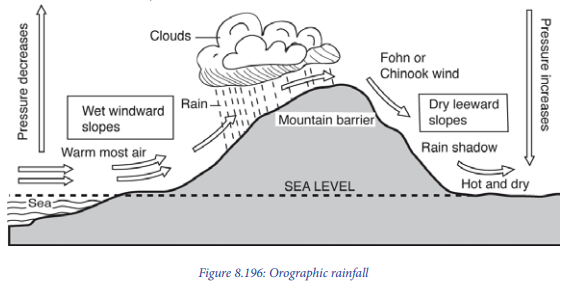
The following conditions are necessary for the orographic rainfall to occur:
– There should be a mountain barrier across the wind direction, so that the moist
air is forced on a barrier (an obstruction) to move upward.
– If mountains are very close and parallel to the sea coasts, they become effective
barriers. Such assists the moisture-laden winds coming from over the Oceans
to rise upward and soon becoming saturated.
– The height of mountains also affects the form and amount of orographic rainfall. Mountains or highlands near the seas or water bodies of reasonable height play a great role in formation of rainfall. Even low height coastal mountains are associated with rainfall formation since the moist air becomes saturated at very low height. On the other hand, the inland mountains should be of higher height because the air after covering long distances loses much of its moisture content.
– There should be enough moisture content in the air.
3. Cyclonic or frontal rainfall Cyclonic or frontal rainfall occurs when air masses of different temperatures meet. One is warm and the other is cold. The warm air is forced over the cool air. As the warm air rises, the moisture in it is cooled. It condenses and falls as rain.
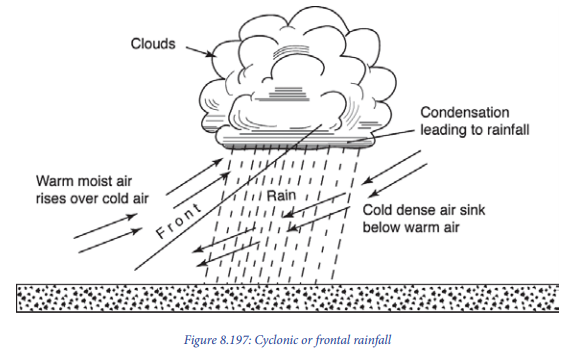
Rainfall associated with ITCZ (Inter Tropical Convergence Zone) results from convergence of cold and warm air masses from the Southern and Northern hemispheres respectively in the equatorial zone. The following are the key conditions for frontal rainfall to occur:
– The moisture content of the air is supposed to be positively correlated with
rainfall
– The convergent or divergent air circulation determines the ascent or descent
of air and its adiabatic cooling or heating. This in turn determines the amount
of precipitation.
– Topographic conditions present both favourable and unfavourable conditions
for precipitation (presence of mountain, near coastal land, etc.)
– Distance from the source of moisture determines the amount of precipitation in different areas.
d. Factors influencing rainfall formation
The spatial and temporal distribution of precipitation over the globe is controlled by the following conditions:
– Moisture content of the air: The atmospheric moisture depends on evaporation of water or ice through the input of heat energy. The regions having high temperature and abundance of surface water, and wide-open Oceanic surfaces for evaporation, receive higher amount of annual rainfall. Equatorial regions are typical examples of such places.
– The convergent or divergent air circulation: The convergent or divergent air circulation determines the ascent or descent of air and its adiabatic cooling or heating which in turn determines the amount of precipitation. The convergence of two contrasting air masses creates frontal activity. In this case, warm air mass is pushed upward by underlying cold air mass resulting into uplifting of warm and moist air mass. The overlying warm and moist air is cooled, and precipitation occurs after condensation. On the other hand, divergent circulation allows descent of air from above and creates anticyclonic condition and atmospheric stability resulting into dry weather. Such situation develops in the subtropical high-pressure area. Therefore, this explain why most of the hot deserts of the world are found in this zone.
– Topographic conditions: Topographic conditions present both favourable and unfavourable conditions for precipitation. If the mountain barriers parallel to the coastal lands and there is onshore moist air, the moist air is forced by mountains to ascend and condense hence yielding precipitation. The leeward side would be dry while the windward side would experience rainfall.
– Distance from the source of moisture: Distance from the source of moisture determines the amount of rainfall in different areas. As the distance from the source of moisture (oceans, seas, rivers) increases, the moisture content reduces and hence the amount of precipitation decreases.
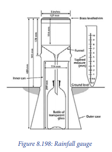
e. Measurement and recording of rainfall
Rainfall is measured using a rain gauge. Many different types of rain-gauge have been designed and used. Most consist of a circular collector and a funnel that channels the collected rain into a measuring mechanism or into a cylinder where it may be measured later. The entrance to the gauge through the funnel is narrow to avoid debris clogging the mechanism and undesirable evaporation in hot weather. To make the rainfall measurement, the observer empties the collected rain into a graduated glass rain measure.
f. Terms related to rainfall
The data obtained from the weather station can be used to calculate the following:
– Daily rainfall total: This is the amount of rainfall recorded in a day.
– Monthly rainfall total: This is the total amount of rainfall received in a month.
It is obtained by calculating the sum of daily rainfall totals in the month.
– The mean monthly totals: This is the average rainfall received per month in
a year. It is obtained by adding the total monthly rainfall received over a given
period (preferably 30 years) and dividing by the number of years.
– The annual rainfall total: This is the total amount of rainfall received in a year.
It is obtained by finding the sum of all the monthly rainfall totals for 12 months.
– Mean annual rainfall: This is the average total annual rainfall received in an
area. It is obtained by adding the total annual rainfall received over a given
period (preferably 30 years) and dividing by the number of years.
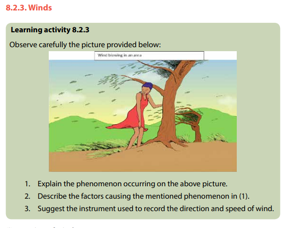
(i) Meaning of wind
Wind is air in motion above the surface of the earth. It is caused by differences in atmospheric or barometric pressure. Air moves from areas of high barometric or atmospheric pressure to areas of low pressure.
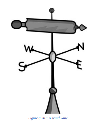
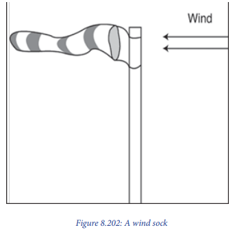
(ii) Measurement and recoding of wind direction
The wind direction is measured with help of a wind vane and wind sock.
Wind vane: It consists of a horizontal rotating arm pivoted on a vertical shaft. The rotating arm has a tail at one end and a pointer at the other. When the wind blows, the arm swings and points to the direction the wind is blowing from. The wind is named after this direction.
Wind sock: It is common in airstrips. It consists of a cylindrical cloth bag tied to a mast. It always points towards the direction at which the wind is blowing.
(iii) Measurement of wind speed
The speed of wind is measured using an anemometer. This consists of three or four metal cups fixed to metal arms that rotate freely on a vertical shaft. When there is wind, the cups rotate. The stronger the wind, the faster the rotation will be. The speed of rotation is recorded on a meter. Wind speed is measured in kilometres per hour. The regions with the same wind speed are called isotachs.

(iv) Factors influencing the nature and movement of winds
The following are the main factors that affect wind direction:
1. The pressure-gradient force: Air flows from areas of higher atmospheric/ barometric pressure to areas of lower pressure. This is the pressure gradient force that sets the air in motion and causes it to move with increasing speed down the gradient. The heating of the earth’s surface is uneven which causes the continual generation of these pressure differences. The greater the atmospheric/barometric pressure difference over a certain horizontal distance, the greater the force and therefore, the stronger the wind.
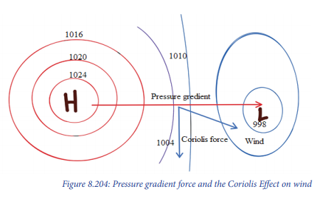
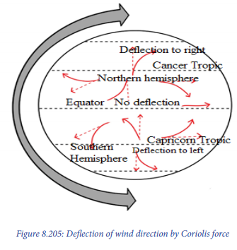
2. The Coriolis force: Winds are deflected to the right in the Northern Hemisphere and to the left in the Southern. The Coriolis force is directed at right angles to the direction of air flow. It does not affect the wind speed, only the wind direction. However, the stronger the wind, the greater the deflecting force. There is no deflection of winds at the equator, but it increases to its maximum at the poles.
3. Frictional force: The irregularities of the earth’s surface offer resistance to the wind motion in form of friction. This force determines the angle at which air will flow across the isobars, as well as the speed at which it will move. It may also alter wind direction
4. Centripetal Acceleration: Due to inward acceleration of air towards the centre of rotation on the rotating earth, it is possible for the air to maintain a curved path (parallel to the isobars), about a local axis of high or low pressure. It is known as centripetal acceleration.
(v) Types of winds
The following are the main types of winds:
– Winds blowing almost in the same directions throughout the year are called
permanent winds or planetary winds.
– Winds which change their directions according to the season are called
seasonal winds (e.g. monsoon winds).
– Winds which change the directions according to the time of the day are called
breezes (sea breezes and land breezes, mountain breezes and valley breezes).
– Winds which blow in a particular locality are called local winds (e.g. Chinook,
Sirocco, Harmattan, Mistral…).
1. Permanent winds or planetary winds
These winds blow from high pressure belts to low pressure belts.
– Easterlies: There are winds which blow from East to West. These are found in both inter-tropical zone and polar zone. The winds blowing in intertropical zone are also called trade winds.
– Westerlies: These types of winds blow from West to East. They are found in the temperate zone between tropics and sub-polar zone.

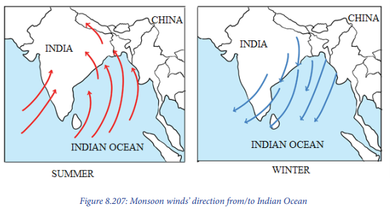
2. Seasonal winds or monsoon winds
Seasonal winds are large-scale surface winds which reverse their directions at least twice a year. Monsoons result from unequal distribution of land and water. They also result from the seasonal heating of the land and oceans. During winter, there is high pressure on the land due to low temperature. Therefore, the air blows from the land (Asia) to the Ocean (Indian Ocean).
This situation is reversed during the summer. High temperature develops over the Ocean, with low pressure over land. Therefore, winds blow from high pressure areas (over the Ocean) to the low-pressure areas (over the land).
Therefore, during summer, they blow from the Ocean (water) to the continent (land).
These winds are found in the following areas:
– In Asia: India Pakistan, Bangladesh, Myanmar (Burma), Thailand, Laos,
Cambodia, North and South Vietnam, Southern China, Philippines.
– Northern coastal areas of Australia.
– South-West coast of Africa including the coasts of Guinea, Sierra Leone, Liberia
and Ivory Coast; Eastern Africa and western Madagascar.
– North-East coast of Latin America e.g. East Venezuela, Guyana, Surinam,
French Guyana, and North-East Brazil, Puerto Rico, Dominican Republic in the
Caribbean Island, parts of Central American and South East USA.
3. Diurnal local winds
These are winds that are caused by daily temperature and pressure variations. They occur because of the heating and cooling during the day and night, plus the difference in the pressures over land and water.
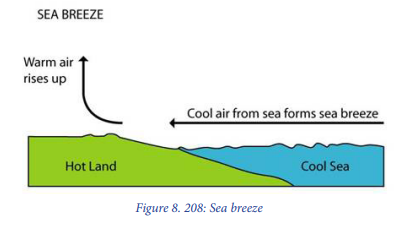
– Sea breezes: Land heats up faster than the sea during the day. Air over the land, therefore, becomes warmer than over the sea. The lighter and warmer air rises. The cooler and heavier air from the sea moves over the land to replace the rising air. This movement of air causes a sea breeze.
– Land breezes: At night, the land cools faster than the sea. The air over the land becomes cooler and heavier than the air above the sea. The warmer air over the sea is lighter. It rises while the cooler heavier air over the land moves to replace it. This creates an air current called a land breeze.

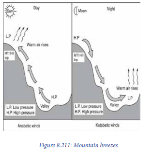
– Valley breezes: The slopes and floors of valleys are heated more at daytime. The warm air moves up the slope or upwards. This movement creates what is called a valley breeze or anabatic wind.
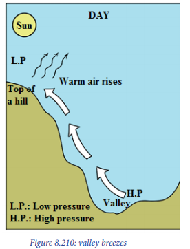
Mountain breezes: During the night, the hill slopes lose heat faster. The valleys remain warmer. A low-pressure gradient is created in the valley. Air current moves down the valley to form what is known as a mountain breeze. It is also called katabatic wind. This explains why some valley floors have frost at night.
4. Non-periodic/local winds
These fall into two groups depending on their temperature (hot and cold winds).
They are found in different areas of the world.
– Hot local winds: Examples are Chinook, Sharmal, Foehn, Khamsin, Harmattan, Sirocco, Simoom, Norwester, Santa Anna, Brickfielder, and Loo.
– Cold local winds: Examples are Mistral, Purga, Bora, Bise, Blizzard, Laventer, Northers and Pampero.
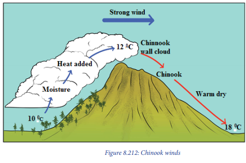
i. Chinook or Foehn winds: These occur when strong regional winds pass over a mountain range. They cool as they rise, dropping moisture on the windward side of the mountain. They descend on the leeward side as cold dry wind. As they go down, they are heated. They can absorb more moisture. Chinook is the name used in the United States of America over Rockies. In Switzerland over the Alps, they are called Foehn winds.
These are other non-periodical local winds:
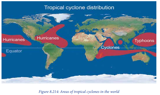
– Hurricanes: These are revolving tropical storms of the Caribbean Sea and Gulf of Mexico. They occur in the Eastern parts of the Pacific Ocean along the coasts of Mexico, Guatemala, Hondulas, Nicaragua, Costa Rica and Panama. Hurricanes occur from August to October.
– Harmattan: These are warm and dry winds blowing from North-East and East to West in the Eastern parts of the Sahara desert. These winds are very dry because of their journey over the Sahara desert. They pick up sand as they blow.
– Sirocco: This is a warm, dry and dusty local wind. It blows Northwards from the Sahara Desert and crosses the Mediterranean Sea to Italy and Spain.
– Typhons: The tropical cyclones in the west Pacific and China sea are known as Typhoons. They occur from June to December. It is an increase low-pressure system which produces violent winds and heavy rains. The magnitude and intensity of typhoons generally exceed those of hurricanes.
– Mistral: This is a cold local wind which blows in Spain and France from NorthWest to South-East. It is more common and effective during winter.
– Tornadoes: Tornado is a rapidly rotating column of air developed around a very intense low- pressure centre. It is associated with a dark funnel-shaped cloud with extremely violent winds, i.e. more than 400 km per hour, accompanied by down pours/heavy rainfall.
– Bora: This is a very cold and dry North-Easterly wind which blows along the shores of the Adriatic Sea.
– Blizzard: This is a violent stormy cold wind that carries with it dry snow. It is common in Siberia, Canada and the USA.
vi. Influence of winds on weather conditions and human activities
Influence of winds on weather conditions
– The way the air moves affects the weather of underlying places. Winds move
heat and cold temperatures from one place to another, transporting conditions
from one geographical zone to another.
– Without wind, weather would not exist. Wind and ocean currents are the
vehicles of water vapour leading to cloud formation which yield rainfall. Heat
or/and cool air masses are moved from one area of the globe to another,
creating weather variations within specific climate zones.
– The wind direction will have an important influence on the expected weather.
Wind direction changes often accompany changes in the weather.
– The wind speed and direction can give the clues to the expected weather
conditions.
Influence of winds on human activities
– The winds with high speed cause the destructions of physical and humanmade environment (e.g. Hurricanes, tornadoes, typhoon, etc.).
– Most of time the tall trees are bent according to the wind directions.
– Exposure of growing plants to hot wind results in dwarfing due to desiccation/
dryness of plant tissue and reduced growth.
– Wind increases crop water requirements by increasing evapotranspiration due
to removal of accumulated humid air near the leaves.
– Calm to moderate wind favour dew deposition needed under condition of soil
moisture stress.
– Moderate wind aids effective pollination. Heavy wind during flowering reduces
pollination, causes flower shed, increases sterility and reduces fruit set in all
crops.
– Wind speed more than 50 km per hour leads to destruction of crops leading
to heavy loss.
– In coastal areas, winds carrying salt sprays can have harmful effect on
susceptible crops.
– Soil and sand particles blown by wind strike the leaves and other plant parts
making punctures, abrasions, scratches and tear the leaves into pieces and
strips. It well marked in maize, sugarcane and banana.
– The turbulence created by wind increase carbon dioxide supply and the
increase in photosynthesis.
– The hot and dry wind makes the cells expanding and early maturity. Therefore,
this results into the dwarfing of plants.
– The coastal area affected by strong winds faces the challenge of high salinity
due to salt particles drawn and deposited on the mainland. This makes the soil
unsuitable for growing plants.
– The crops on the windward slopes yield more.
vii. Air masses
1. Meaning of air masses
Air mass may be defined as a large body of air whose physical properties, especially temperature, moisture content, and lapse rate (of temperature) are uniform horizontally for hundreds of kilometres.
2. Types of the air masses
Based on geographical location of air masses, Trewartha classifies them into the following two broad categories:
– Polar air masses. This type is subdivided into continental air masses and Maritime Air masses.
a. Continental polar air masses: These are characterized by cold temperatures and little moisture. They are found on the continent mostly in the polar zones such as Northern portions of the United States. These conditions usually result from the invasion of cold arctic air masses that originate from the snow-covered regions of northern Canada.
b. Maritime polar air masses: These are cool, moist, and unstable. Some maritime polar air masses originate as continental polar air masses over Asia and move westward over the Pacific, collecting warmth and moisture from the Ocean.
– Tropical air masses: These are also subdivided into continental and maritime air masses.
a. Continental Tropical Air Mass: The source region for this type is the desert Southwest, the high plains and Mexico with relation to the United States. The air has low dew points and warm to hot afternoon temperatures but with mild night time temperature. Skies are generally clear in Continental Tropical Air mass.
b. Maritime Tropical Air Mass: This originates over the warm waters of the tropics and Gulf of Mexico, where heat and moisture are transferred to the overlying air from the waters below. The Northward movement of tropical air masses transports warm moist air into the United States, increasing the potential for precipitation.
3. Characteristics of the air masses
The basic characteristic features of air masses include the following:
– Air masses can either be cold or warm depending on the source region.
– They can be maritime (originating over oceans) or continental in nature
depending on the trajectory taken.
– Air masses have specific direction of movement from fixed source region.
– Air masses move from one region to another following the pattern of
barometric pressure. (From areas of high pressure to areas of Low pressure.)
– Throughout the air body there is unvarying humidity content with the same
characteristics.
– Air masses usually have uniform temperature characteristics over a long
distance.
– Air masses are independent even when they come into contact with each
other, do not merge into each other but retain their identity.
– Air massess are directly connected or associated with the planetary wind
systems. That is, every air mass is related with one or the other permanent
wind belt.
4. The formation of the air masses
The air masses are formed from extensive and broadly uniform areas. The nature and properties of the originating areas largely determine the temperature and moisture characteristics of air masses. An ideal source region of air mass must possess the following essential conditions.
– There must be extensive and homogeneous earth’s surface so that it may
possess uniform temperature and moisture conditions. The source region
should be either land surface such as a desert or Ocean surface.
– There should not be convergence of air, rather there should be divergence of
air flow. This is important for the air to stay over the region for longer period to
have the ability of having uniform temperature and humidity.
– Atmospheric conditions should be stable for considerable long period of time.
This is necessary because the air must attain the characteristics of the surface.
5. Effects of air masses on the environment
– When air masses hover for a while over a surface area with uniform humidity
and temperature, it takes on the characteristics of the area below, and
influences the environment of that area.
– When two air masses of different properties meet, the cold air pushes the hot
air upwards. The uplifted moist air condenses to yield rainfall or precipitation.
– There is formation of a stationary front especially when neither air mass
displaces the other. This leads to formation of clouds that yield varying kinds
of precipitation.
– Maritime air masses are associated with humid conditions. This is because as
air travels over the Oceans it picks moisture that is later dropped in form of
precipitation. Therefore, it produces the warm and humid conditions in the
areas they bathe.
– The continental air masses lead to formation of dry weather. This is because the
continents just can’t compete with the Oceans when it comes to moisture. The
continental air masses produce dry, cold weather in the winter and pleasant
weather conditions in the summer.
– When the air is lifted over an obstacle like a mountain, such lifting is known as
orographic lifting. This leads to occurrence of varying weather conditions. The
windward side receives rainfall while the leeward, becomes dry.
6. Cyclones:
1. Meaning of cyclone
A cyclone is a large-scale air mass that rotates around strong centres of low pressure. This is usually characterized by inward spiralling winds that rotate Anti-clockwise in the Northern Hemisphere and clockwise in the Southern Hemisphere of the Earth.

2. Areas of cyclones in the world
Most large-scale cyclonic circulations are centred on areas of low atmospheric pressure. The main cyclones are tropical cyclones which are the typhoon of the Pacific Ocean and hurricane of Atlantic; cold- polar cyclones and extra tropical cyclones.
There are six general regions of occurrence:
– The Caribbean Sea and Gulf of Mexico.
– The Northwest Pacific from the Philippines to the China Sea.
– The Pacific Ocean west of Mexico.
– The South Indian Ocean east of Madagascar.
– The North Indian Ocean in the Bay of Bengal and
– The Arabian Sea.
3. Characteristics of cyclones
– A cyclone is simply an area of low pressure around which the winds blow
counter clockwise in the Northern Hemisphere and clockwise in the Southern
Hemisphere.
– Cyclones form and grow near the front.
– Cyclones (lows) are cloudy, wet, and stormy.
– The largest low-pressure systems are cold-core polar cyclones and extra
tropical cyclones which lie on the synoptic scale.
– Warm-core cyclones such as tropical cyclones and subtropical cyclones also lie
within the synoptic scale.
– Upper level cyclones can exist without the presence of a surface low.
– Tropical cyclones form due to latent heat driven by significant thunderstorm
activity. In this case, humidity plays a great role in generation of this heat that
drives the whole wind system.
– Cyclones can transition between extra tropical, subtropical, and tropical
phases under the right conditions.
4. Formation of cyclones (depressions)
Tropical cyclones develop due to two factors as explained here under;
– When two differing air masses of varying characteristics in terms of temperature
and humidity meet over the surface of the Ocean. Or sometimes when there
is the local heating from the surface especially of the Ocean water that creates
the area of intense low pressure.
– Winds of varying characteristics move towards this low pressure and yet hardly
mix up. But instead, start circulating and spinning in a spiral nature around an
area of low pressure.
– As earier said, when two varying air masses meet, the warm air rises over
the cold air and the moisture contained therein undergoes the process of
condensetion and leading to terretial rainfall.ely
– Through the process of condesetion latent heat is released and it is this energy
that facilitates the rotation and spiral nature of the cyclone.
– Over the tropical maritime/Oceans, the intense heating creates an area of low
pressure and the cold air masses rush towards this area and setting the creation
of a tropical cyclone as the humidity increases and latent heat generated.
5. Effects of cyclones on the environment
– There are several effects of cyclones on the environment. These are explained
hereunder:
– Tropical cyclones are associated with heavy rain, strong wind, large storm
surges and tornadoes.
– They trigger landslides and mudslides. This is because of the heavy rainfall that
comes along with the tropical cyclones.
– They cause destruction of vegetation and wildlife in general. This is because
of the stormy nature of the rainfall associated with cyclones. Therefore, trees
break down and their canopies completely trimmed off.
– They cause severe erosion especially along the coastal regions that are usually
most hit by tropical cyclones. Especially the removal and reshaping of the sand
dunes.
Anticyclone:
Meaning of anticyclone
An anticyclone is known as a large-scale circulation of winds around a central region of high atmospheric pressure. The winds blow clockwise in the northern hemisphere and counter clockwise in the southern hemisphere.
Areas of Anticyclone
The classification of anticyclones is based on their location or areas where they occur. They are categorized into four classes which are described hereunder:
– The subtropical Highs: The subtropical highs are large, elongated, very deep
anti- cyclones situated at tropical regions.
– The polar continental Highs: The polar continental highs (anticyclones) are
prominent over Northern continents in winter. The conditions of Alaska, western
Canada and Rocky Mountains are most favourable for their development.
– High within the cyclone Series: Anticyclones with small horizontal extent are
sometimes present between the individual members of the cyclone family.
– The polar highs: These polar highs occur at the end of a temperate cyclone.
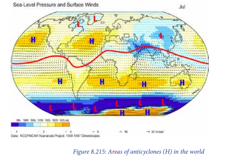
Occurrence of anticyclones
The anticyclones occur in sub-tropical high-pressure, belt extending between the latitudes of 250-350 and in Polar Regions in both Hemispheres.
Characteristics of anticyclones
The ‘highs’ or ‘anticyclones’ are characterized by divergent wind circulation. Whereby, winds blow from the centre outwardly in clockwise direction in the northern hemisphere and anti-clockwise in the southern hemisphere. The high-pressure systems are indicative of dry weather conditions. Therefore, anticyclones are called weather less phenomena.
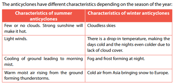
Effects of anticyclones on the environment
The following are the major effects of Anticyclones on the environment:
– Descending and divergence movements of the anticyclones result into
cloudless skies leading to dry weather conditions. These dry weather conditions
may result into drought in the affected areas.
– The Anticyclones have been one of the causes of hot deserts of the world,
especially in the western parts of the continents near the tropics.
– The cloudless skies over the areas affected by anticyclones result into the
reception of higher amount of solar radiation on the earth’s surface. This makes
the soil to become drier and vegetation experiences the water shortage.
– The anticyclone makes the temperature range to be higher because the days
are hot, and nights are very cold. This has negative impact on the vegetation
and other living things.
8.2.4. Atmospheric humidity

i. Meaning of atmospheric humidity
Atmospheric humidity is the amount of water vapour in the atmosphere. The water comes as a result of evaporation and transpiration by plants. It also comes from volcanic activity through hot springs. The water vapour determines the amount of precipitation in an area.
ii. Measurement and recording of humidity
Atmospheric humidity is measured using a hygrometer. It consists of a system of levers linked to a pen and record chart or graph paper. Within it, are threads of human hair. When humidity rises, the threads absorb moisture and become longer. When humidity falls, they dry and become shorter. The levers make these movements appear large. The pen records them on the graph paper.

iii. Types of atmospheric humidity
The following are the main types of the atmospheric humidity:
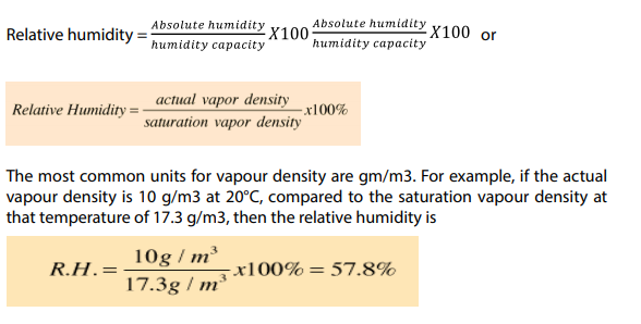
1. Absolute humidity: Absolute humidity is defined as amount of water vapour per unit volume of air at a given temperature. It is expressed in gram per cubic meter volume of air (gr/m3). Absolute humidity changes with changing temperature. For example, it is 1gr/m3 at - 200C in cold continental area during winter season while it will be more than 30 gr / m3 at 200 C in maritime equatorial region.
2. Relative humidity: Relative humidity is defined as a ratio of the air’s actual water vapour content compared with the amount of water vapour air can hold at that temperature and pressure.
3. Relative humidity is generally expressed as percentage. Relative humidity is calculated as follows:
iv. Factors influencing atmospheric humidity
The following factors affect humidity:
– Temperature: An increase in the temperature of the air increases its ability to
hold moisture.
– Amount of water available: There is more evaporation over the Ocean than
the land. Therefore, there is more moisture over the Ocean than the land.
– Wind-speed: Evaporation depends on the speed of wind. When the winds
are light, a thin layer of air just above the surface gets almost full of moisture.
When the wind speed is high, the air has less moisture.
Area of the evaporating surface: Larger areas where evaporation occurs
increase the rate of evaporation.
– Air-pressure: Evaporation is also affected by the atmospheric pressure exerted
on the exposed surface of water. Low pressure on open surfaces of the liquid
results in higher rates of evaporation.
– Composition of water: The rate of evaporation is always greater over fresh
water than over salty water.
v. The significance of humidity to the environment
– Humidity drives most of the observable weather phenomena starting with
clouds, fog, rain, storms and finally to such dramatic weather conditions such
as hurricanes.
– It facilitates the weather fore casting. It is not possible to forecast the weather
exactly without precise knowledge of humidity in all the layers of the
atmosphere.
– Correct relative humidity is important for our well-being and health.
– It enables the hydrological cycle to operate normally. It enables much water
in form of vapour to be kept or stored in the atmosphere. Such is condensed
later to form precipitation.
– Humidity plays a great role in stabilising climate of various areas. This is
because of its regulating ability that prevents the occurrence of extreme levels
of temperatures.
– It affects many properties of air and of materials in contact with air.
– Water vapour is a key agent in both weather and climate, and it is an important
atmospheric greenhouse gas. This plays part in regulating the Earth’s
temperature.
– Humidity measurements contribute both to achieving correct environmental
conditions that sustain various ecosystems.
8.2.5. Cloud cover
Learning activity 8.2.5
Read critically the context below and answer the questions that follow: Daniella always wakes up and observes the horizon of the sky. One day, she observed the sky and found out that it was clear with white colour. She continues to take note of the daily occurrences of the nature of the sky. The next day she observed black colour in the sky, another day she found sky approaching the tops of hills and the last day of her last observation; she observed the sky being dark and reaching the ground. Now Daniella is asking herself what is happening in the sky.
Help Daniella to be satisfied with clear explanations to her question through
answering the following questions:
1. Explain what causes the different colours that arise in the horizon of the
sky.
2. Describe the effects of the last observation of Daniella to the
environment.
i. Meaning of cloud
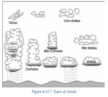
A cloud is an aggregation or grouping of moisture droplets and ice crystals that are suspended in the air. A cloud is made up of water droplets or ice particles suspended in the air. These particles have a diameter ranging between 20 mm and 50 mm.
ii. Types of clouds and their characteristics
Clouds are classified according to altitude and form. With regard to form, there
are:
a. Stratified clouds: These are layered clouds. They look like blankets and cover
large areas. They can give large amounts of rain or snow.
b. Cumuliform clouds: These have bubble-like bodies. They give rain over a small
area.
With regard to altitude, clouds are classified as high clouds, middle clouds and
low clouds.
a. High clouds (form above 6,000 m above the sea level). They look like feathers.
They appear in separate groups in fair weather. In bad weather, they are joined
together. The following are examples:
– Cirrus
– Cirrostratus
– Cirro-cumulus
b. Middle clouds (form between 4,000 and 6,000 metres). They are thick clouds.
The following are examples:
– Alto-stratus
– Alto-cumulus
They are mostly distributed over the whole sky. They appear white or grey.
c. Low clouds (Form below 2,000 metres). They are usually shallow. The following
are examples:
– Stratus: They are dense, low-lying fog-like clouds of dark grey colour. They are
composed of several uniform layers.
– Strato-cumulus: They are generally associated with fair or clear weather but
occasional rain or snow.
– Nimbo-stratus (Ns): They are middle and low clouds of dark colour. They are
associated with rain.
d. Clouds with great vertical extent: They are found between 2,000 and 10,000
metres. They are white but may appear grey or black. They give heavy rainfall.
The following are examples:
– Cumulus: They are very dense, widespread and dome-shaped. They also
have flat bases and are associated with fair weather. These sometimes are
characterised by thunder.
– Cumulo-nimbus: They are thunder-storm clouds. They show great vertical
development/extent and produce heavy rains, snow or hailstorm accompanied
by lightning, thunder and gusty winds. They appear like mountains or huge
towers.
iii. Factors influencing the formation and the shape of clouds
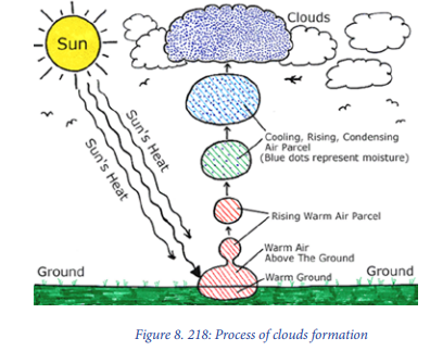
The sun plays a major role in formation of clouds. The first step of cloud formation is related to the rising of the air into the atmosphere. Such air must be moist or carrying water vapour that is later condensed to form clouds. The following are the major factors influencing the rise of air into the atmosphere:
Bottom of Form
Bottom of Form
– Sun: The sun heats the earth and thus the air rises, expands, and cools.
– Topography: Clouds are also formed when air encounters mountains or other
topography. The air rises and cools, condensing to form clouds.
– Low pressure: This influences air to move towards the areas of low pressure.
Therefore, different kinds of air of varying characteristics meet but not
necessarily mixing up. The cold air forces the warm and moist air to rise and
hence, cool and condensing to form clouds.
– Clouds can be formed when air rises along the slope of a mountain. This aids
the moist air to reach the atmosphere where it cools down, condensing and as
a result, clouds are formed.
– Warm and cold fronts: Weather fronts cause the rise of the air. Specifically,
warm fronts make the air to condense because the warm air rises above the
cold air. This results into the formation of clouds.
iv. Effects of clouds on weather
The clouds are much important on weather conditions prevailing in a given area as
it is explained below:
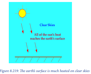
– During the day, the earth is heated by the sun. If skies are clear, more heat
reaches the earth’s surface (as in the diagram below). This leads to warmer
temperatures.
If skies are cloudy, some of the sun’s rays are reflected off the cloud droplets back into space. Therefore, less of the sun’s energy is able to reach the earth’s surface. This causes the earth to heat up more slowly. This leads to cooler temperatures.
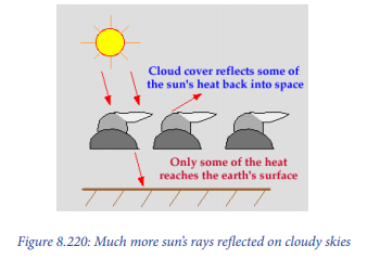
Cloudy skies lead to existence of lower temperatures since much of the sun’s isolation will be blocked from reaching the earth’s surface. The clear skies during day, leads to increase in temperature. At night, cloud cover has the opposite effect. If skies are clear, heat emitted from the earth’s surface freely escapes into space, resulting in colder temperatures.
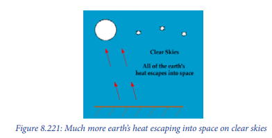
If clouds are present, some of the heat emitted from the earth’s surface is trapped by the clouds. This heat is reemitted back towards the earth. As a result, temperatures decrease more slowly than if the skies were clear.

i. Meaning of sunshine
The sunshine is composed of two words: sun and shine; it means the period of shining of the sun. The sunshine is observed and recorded during the day time.
ii. Measurement and recording of sunshine
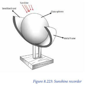
This is done using a Campbell-stokes sunshine recorder. The instrument records the duration and intensity of sunshine.
This is a glass sphere which is partially surrounded by a metal frame on which there is a sensitized or calibrated card. The card is graduated in hours and minutes. When the sun shines, the glass sphere focus the sun’s rays on the card and as the sun moves across the sky, the rays burn a trace on the card. This only happens when the sun is shining. At the end of the day, the card is taken out and the length of trace is turned into hours and minutes, which represents the total amount of sunshine for the day. A line on the topographic map joining places of equal sunshine is called “Isohel”
iii. Factors influencing the amount of solar radiation
All parts of the world do not receive the same amount of solar radiation because of the following factors:
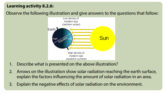
– Angle of the sun’s rays: The angle between the rays of the sun and the tangent to the surface of the earth at a given place, largely determines the amount of insolation to be received at the place. The angle of the sun’s rays decreases as one moves towards the poles. Vertical rays bring more solar radiation.

– Length of the day: The shorter the duration of sunshine and longer the period of night. This results into lesser amount of solar radiation received at the earth’s surface and vice versa. This happens due to spatial variations of the length of the day from the equator to the polar region, due to the inclination of the Earth’s axis (Reference to the unit 4 on the consequences of revolution of the earth).
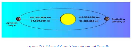
– Distance between the Earth and the Sun: The distance between the sun and the earth changes during the course of a year. This is because the Earth revolves around the sun in an elliptical orbit. The average distance between the sun and the earth is about 149 million km. At the time of perihelion (on January 3) the earth is nearest to the sun (147 million km) while at the time of aphelion (on July 4) it is farthest from the sun, that is, (152 million Km) away. At the time of perihelion, the earth should receive maximum insolation while at the time of aphelion it should receive minimum insolation.
– Sunspots: Sunspots are defined as dark areas within the photosphere of the sun. They are created in the solar surface (photosphere) due to periodic disturbances and explosions. The increase and decrease of the number of sunspots is completed in a cycle of 11 to 24 years. It is believed that the energy radiated from the sun, increases when the number of sunspots rises and consequently the amount of solar radiation received at the earth’s surface also upsurges. On the other hand, the amount of solar radiation received at the earth’s surface decreases with decrease in the number of sunspots due to less emission of radiation from the sun.
– Effects of the atmosphere: As solar radiation travels a long distance from the sun to the earth’s surface; there are some portions of the solar energy which are lost through the processes of reflection, diffusion, absorption and scattering.
iv. Influence of sunshine on the environment
The sunshine has both positive and negative effects on the environment as it is
explained below:
Positive effects
– Health benefits: Humans require between 1,000 and 2,000 units of vitamin D
daily for optimum health. The skin creates vitamin D naturally when exposed
to solar radiation, and spending 10 or 15 minutes a day outside can give all
body to stay healthy
– Needed for photosynthesis: Sunshine is needed in photosynthesis processes
for autotrophy green plants and algae to produce the compounds necessary
for their survival.
– Disinfection: Exposing bottled water to sunlight for six hours or more can kill
many harmful pathogens, and developing nations often use this technique
as a low-cost method of treating water supplies against common bacterial
contaminants.
– Production of energy: Sunshine can produce the energy which may be used
for different purposes.
Negative effects
– Skin Cancer: The ultraviolet radiation present in sunlight can also cause
damage to the human and animal skins. Short exposures to intense sunlight
during the summer months can produce painful sunburns, while longerterm exposure to ultra violet can damage cells, altering the DNA and possibly
leading to skin cancer.
– Eye Damage: Solar radiation can also prove harmful to the human and animal
eyes.
– Damaging the crops and other vegetation: The excess of daily sunshine without rain for long-term, becomes harmful to crops and other vegetation because all water which would support the crops/vegetation evaporates.
8.2.7. Atmospheric pressure
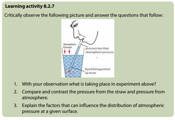
Meaning of atmospheric pressure
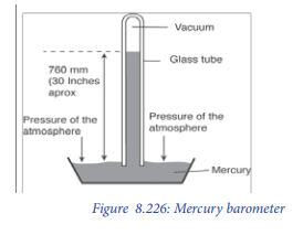
Atmospheric pressure is the force per unit area that is exerted against the Earth’s surface by the weight of air above it. The unit area could be one square centimetre or one square meter. Atmospheric pressure is measured in terms of the height of mercury in the glass tube in a mercury barometer. The standard air pressure at sea level is 1013.25 mb or 29.92 inches or 760 mm at temperature of 15 °C at the latitude of 45°.
Measurement and recording of atmospheric pressure
The barometer is the instrument used to measure atmospheric pressure. There are two types of barometers: Mercury barometer and Aneroid barometer.
a. Mercury barometer
It is made of a one-meter-long glass tube. It is closed at one end and filled with mercury. The open end of the tube is then opened below the surface of mercury in a bowl. A vacuum is left above the mercury and the column is supported by the air pressure outside. Air pressure is obtained by observing the length of the mercury column.
b. Aneroid barometer
Aneroid barometer is made of a small metal box which contains a very little amount of air. It expands and collapses under the influence of any change in atmospheric pressure. See the figure below.

Factors influencing the distribution of atmospheric pressure
The following factors influence atmospheric pressure:
– Altitude: Air pressure at sea level is higher than at the top of a mountain. This means that pressure decreases with increase in altitude. The pressure at the ground level is higher than that at the top of high mountains. This is because air at the ground level has to support the weight of the air above it, and the molecules in the bottom air must push outwards with a force equal to that exerted by the air above it.
– Temperature: When air is heated, it expands. When this happens, the outward pressure of its molecules is spread over a large area. This means the pressure of the air decreases. The pressure of the air therefore rises when its temperature falls.
– Latitude: The earth is not a perfect sphere and therefore force of gravity varies according to latitude. This is at maximum at the poles and a minimum at the equator. Atmospheric pressure is therefore lower at the equator and higher at the poles. Therefore, Air pressure increases with latitude
– Season of the year: Atmospheric pressure changes with seasons of the year being high over the cold continental interiors in winter and conversely low over the heated continents in summer.
– The nature of earth’s surface: During the day, land heats up more than the water and hence air pressure is lower over land than the sea. Air blows from the sea to the land as a sea breeze. On the other hand, during the night, the land cools more quickly than the sea and hence air pressure is lower over the sea than land. Wind blows in from the land to the sea as a land breeze.
Pressure types
Air pressure is generally divided into two types. These are high pressure (HP: above 1013.25 mb), and low pressure (LP: below 1013.25 mb).
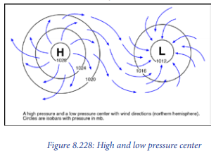
– High pressure systems are also called highs or anticyclones. They are characterized by highest air pressure in the center of almost closed isobars where pressure decreases from the center outwardly. The lowest pressure is found at the outer margin of the high-pressure system.
– Low pressure systems are also called low or simply L or cyclones or depressions. These are centres of low pressure, having increasing pressure outwardly. This has closed air circulation from outside towards the central low pressure in such a way that air blows inwardly in anti- clockwise in the northern hemisphere and clockwise in the southern hemisphere.
Location of different world pressure belts and their characteristics
There are seven pressure belts on the globe:
– Equatorial low-pressure belt: It is located on either side of the geographical equator in a zone extending between 5° N and 5° S latitudes. But this zone is not stationary because there is seasonal shift of this belt in relation to the northward (summer solstice) and southward (winter solstice) migration of the sun. The equatorial low-pressure belt represents the zone of convergence of North-East and South-East trade winds.
– Sub-tropical high-pressure belt: It extends between the latitudes of 25°- 35° in both the hemispheres. The divergence movement is prevailing over the surface on that belt. The descending movement of winds results into the contraction of their volume, increases in density, and ultimately causes high pressure. Therefore, this explains why this zone is characterized by anticyclonic conditions which cause atmospheric stability and aridity.
– Sub-polar low-pressure belt: It is located between 60°-65° latitudes in both hemispheres. It may be noted that due to the great contrast of temperature of the continents and Oceans, during Northern summer, the low-pressure belt becomes discontinuous and is found in a few low-pressure cells. While in winter season the pressure increases, and the low-pressure belt becomes less regular.
– Polar high-pressure belt: Temperature remains below freezing point during most part of the year. This results into the high-pressure systems throughout the year. Winds blow from the polar high pressure to sub-polar low-pressure cells. These are called polar winds which are North-Easterly in the Northern hemisphere and South-Easterly in the Southern hemisphere.

8.3. Factors that influence world climate
Learning activity 8.3
Explain how the following influence climate of any region:
a. Latitude
b. Altitude
c. Water bodies
The following are the main factors influencing world climates:
– Latitude: The climate of a place is influenced by latitude. Temperature and
precipitation are high near the equator while they are low at the polar zone.
This is because of the amount of sunshine received at these places. The amount
of sunshine received by the ground surface decreases away from the equator.
– Altitude: Temperature decreases with increasing in height from the earth’s
surface. Precipitation on the other hand increases with altitude. Temperatures
at the top of mountains are very low. On the other hand, precipitation and
humidity are very high.
– Presence or absence of water bodies: Places near a lake or sea have low
temperatures. This is because of the cooling effect of air currents or breeze
from the water bodies. Areas far away from water bodies have extreme weather
conditions.
– Vegetation: Vegetation attracts precipitation and moderate temperatures.
Through transpiration, clouds form near the forests and precipitation occurs.
Transpiration is the evaporation of water from leaves and stems of plants. It
rains a lot in the equatorial dense forests. In the deserts where there are few
plants, it is dry and hot.
– Human activities: Pollution from industries affects the climate. Chemicals and
gases that are released into the atmosphere cause acid rain. Cutting down of
forests also affects the climate. Where forests are cut down in large numbers,
reduced precipitation is recorded.
– Ocean currents: The warm ocean currents from tropical areas to cold zones
raise the temperature in these areas. For example, the Gulf Stream increases
the temperature of the coastal areas of North-Western Europe. While Kuroshio
warm currents raise the temperature of the coasts of Japan.
– Primary wind circulation also called the primary atmospheric circulation is the main factor controlling the spatial distribution of climates in the world. This circulation involves flow patterns of permanent wind systems in latitudinal zones from the equator towards the poles. This primary wind circulation of Easterlies (trade winds) and Westerlies divide the world into three major zones. These include Intertropical zone, mid-latitude zone and sub-polar zones. In these areas winds blow from high pressure belts to low pressure belts.
The description the three primary wind circulation major zones:
– Intertropical zone: This is the zone where winds from subtropical highpressure areas blow towards. It is an equatorial low-pressure area. Therefore, marks the zone of convergence that creates Intertropical fronts (ITF) or Intertropical Convergence (ITC). Then, the air near the equator is heated due to solar radiation, rises upward to yield enough rainfall in this zone.
– Mid-Latitude zone: Mid-latitude zonal circulation extends between 30° and 60° latitudes in the northern and the southern hemispheres. This zone is under the influence of subtropical high-pressure belt (300-350 latitudes). This belt separates two wind systems. Trade winds (Easterlies) and Westerlies. It is also apparent that the subtropical high-pressure belt is the source of the origin of trade winds. These blow towards equatorial low-pressure belt. On the other hand, the westerlies blow towards sub-polar low-pressure belt. This is because winds always blow from high pressure to low pressure. This movement of winds makes the zone to be drier.
– Sub-polar zone: This zone is confined mostly between 600-900 latitudes in both hemispheres and is characterized by surface polar Easterly winds. Winds blow from the polar high pressure to sub-polar low-pressure cells. These are called polar winds which are North-Easterly in the northern hemisphere and South-Easterly in the Southern Hemisphere. Therefore, sub-polar low-pressure belt becomes convergence zone; where the front is formed to allow the air to rise upward to yield rainfall around this belt.
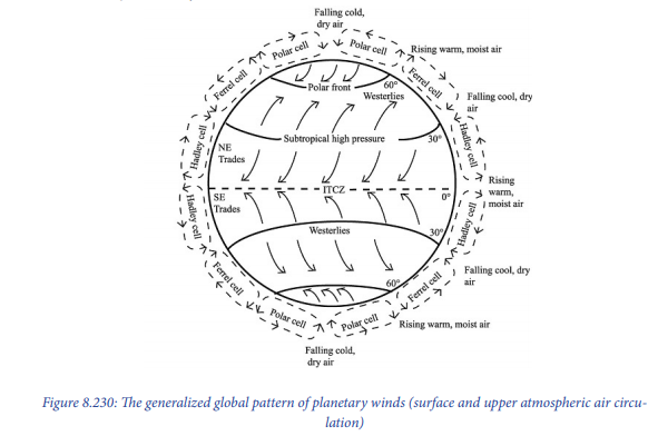
– Monsoons winds: These are seasonal winds which reverse their direction at least twice a year. This results into the air blowing from the land to the Ocean in winter and from Ocean (water) to the land in summer. This situation makes the summer to be hot and wet and winter to be cold and dry in the affected areas.
Application activity 8.3
Read the following context and give feedback to the questions that follow:
Generally, climate of any region or area is influenced by both physical factors (Latitude, altitude, water bodies, vegetation, ocean currents and aspect in relation to location) and human factors (pollution from industries, Chemicals released into the atmosphere, cutting down of forests /deforestation, over cultivation, overgrazing, land reclamation and construction). Illustrate these geographical factors in Rwandan context.
8.4. Types of climate and their characteristics
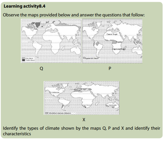
The classification of climatic zones is based on temperature and rainfall. There are three world climatic zones. These are: Tropical, Temperate and Cold zones.
8.4.1. Tropical zones
i. Equatorial climate
Equatorial climate is also called tropical wet climate or tropical rainforest climate. It is found along the equator extending from 5° to 10° South and North latitudes. Along the Eastern margin of continents, it spreads to 15° - 25° of latitudes. This type of climate is found specifically in the following regions:
– The Amazon River Basin in South America
– The Congo Basin and Guinea coast in Africa
– Malaysia, Indonesia and the Philippines Islands in South-Eastern Asia
– Eastern and Central America (parts of Panama, Costa Rica, Nicaragua, Honduras,
British Honduras and Guatemala), some islands in the Western Colombia
– Coastal lowlands of Eastern Brazil
– Eastern Madagascar
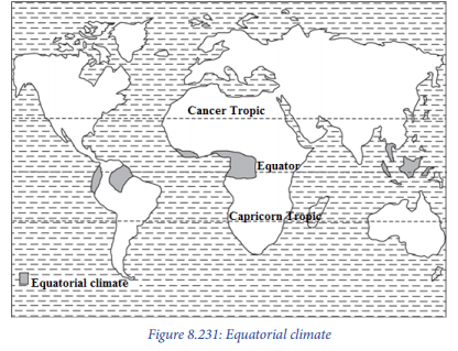
ii. Climatic characteristics of equatorial region
– This climatic region is located within 5° North to 10° South of the Equator.
– The average monthly temperatures are over 18°c. However, many places
record average monthly temperatures of 24° to 27°c.
– The Equatorial regions lie in a belt where the winds are light. It is a low-pressure
belt.
– The annual range of temperature is very small (the difference between the
highest and the lowest temperatures) varies from 5°to 8°c.
– The equatorial regions get heavy precipitation throughout the year. Many
areas receive 2000 mm of the rain per year. The annual average rainfall in the
equatorial climate is nearly 2500 mm.
– There is a large amount of cloudiness.
– Conventional rainfall is received, and it is usually accompanied by
thunderstorms.
– High temperatures and heavy rainfall encourage growth of natural vegetation.
There are evergreen dense forests.
Below there is an example of Singapore weather station:
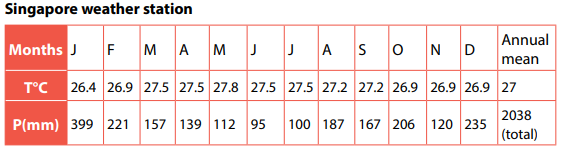
iii. Tropical marine climate
It is found on the East coasts of regions lying between 10° N and 25° N and 10° S and 25° S of the equator. These areas come under the influence of on-shore Trade Winds. Examples are East coast of Brazil, the Eastern coastlands of Madagascar, Mexico, Nicaragua, Guatemala, Venezuela, the lowlands of Central America, West Indies, the coast of Queensland (Australia) and the southern islands of the Philippines.
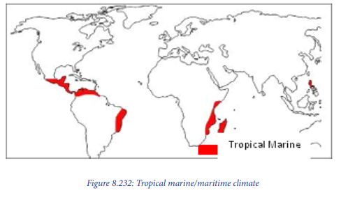
Climatic characteristics of Tropical maritime/maritime climate
The annual temperature range is about 8°c.
Temperatures reach 29°c during the hot season while it is about 21°c during the cold
season,
Annual rainfall varies from 1000 mm to 2000 mm.
Rainfall received is both convection and orographic brought by onshore Trade
Winds.
Humidity is high throughout the year.
Sea breezes lessen the effects of the heat.
Tropical maritime climate is good for tree growth. The lowlands have tall and
evergreen trees.
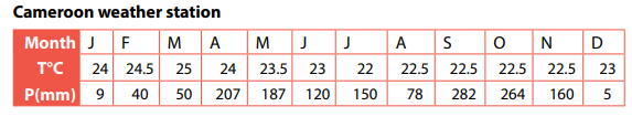
iv. Tropical continental climate
This climate occurs between 5° N and 15° N and 5° S and 15° S. It is in West, East and Central Africa, South America, parts of the Deccan plateau (India) and the areas to the north and east of the Australian Desert.

Climatic characteristics of Tropical continental climate
– Heavy convectional rainfall is mainly in the summer.
– Annual rainfall is about 765 mm.
– In some regions, the offshore winds are strong and hot. An example is the
Harmattan of West Africa.
– Humidity is high during the hot, wet season.
– Summers are hot (32° C) and winters are cool (21° C).
– The annual temperature range is about 11°C. The highest temperatures occur
just before the rainy season begins. This is in April in the northern hemisphere
and October in the southern hemisphere.
v. Savannah climate (Tropical wet-and-dry climate)
This is located between 5° and 20° latitudes on either side of the Equator. It is found in Latin America. These are the Llanos of the Orinoco Valley including Colombia and Venezuela, the Guyana Highlands and the Campos of Brazil.
In Africa, it is found in the South of the Congo basin, the Southern part of Democratic of Republic of Congo, Angola, Zambia, Mozambique, Tanzania, Uganda, Botswana, South-Western Madagascar, Central Nigeria, Southern Kenya, Togo, Ghana and Ivory Coast.

Climatic characteristics of Savannah Tropical climate
– High temperature of around 20°c.
– The annual range of temperature is greater than in the equatorial regions. It is
over 3° but not more than 8°c.
– Total annual average precipitation varies from 1000 mm to 1500 mm. Much of
the rain falls during the summer.
– The vegetation is grasslands with scattered trees and bushes.
vi. Tropical desert climate
Most of these deserts lie between 15° to 35° N and S. The hot desert climate is found in the following deserts: Atacama (the coastal deserts of Peru and Chile in South America), the Namib and Kalahari deserts of coastal Angola and South West Africa, interior part of Botswana and South Africa, the great Australian desert, the Sahara and the Arabian deserts, the Iranian desert, the Thar desert of Pakistan and India, California (USA) and the deserts of Northern Mexico.
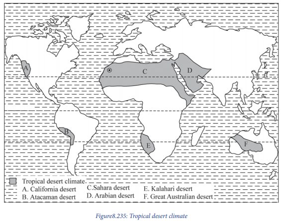
Climatic characteristics of Tropical desert climate
– Hot deserts have the highest temperatures recorded.
– They have cloudless skies and little or no water vapour.
– The daily ranges of temperature vary between 22° to 28° C. In rare cases, the
diurnal range may be as high as 41.7° C.
– The annual average precipitation is less than 250 mm.
– Relative humidity is high.
– There is little plant cover.
– Below there is an example of Khartoum (Sudan) weather station:
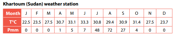
vii. Tropical Monsoon Climate
This is found in areas with seasonal land and sea winds. On-shore summer winds blowing from over tropical warm Oceans bring about heavy precipitation. Offshore winds from over the land make the weather dry during winter. Monsoon climate is found in the coastal areas of Eastern and Southern Asia. These places include India, Burma, Bangladesh, Indo-china, Southern China, and Philippines, Taiwan, Japan and Korea.
In tropical Africa, it is found along the South-West coast of West Africa. These areas include the coasts of Guinea, Sierra Leone, Liberia, and Ivory Coast. Other areas are the Northeast coast of Latin America from the mouth of Orinoco River in Eastern Venezuela through Guyana, Surinam and French Guyana to the North-Eastern part of Brazil. The North coasts of Puerto Rico and the Dominican Republic in the Caribbean Islands which have a mild monsoon climate.

Characteristics of Tropical monsoon climate
– High temperatures (32°c) in the hot season (summer) and low temperatures
(15°c) in the cold season (winter).
– High annual range of temperatures of about 17°c.
– Summers receive high rainfall of up to 2500 mm.
– The winters are dry.
– There is a reversal of winds. In one season they blow from sea to land (onshore).
These bring heavy rainfall. In the other season, they blow away from the sea
(offshore), such come along with little rain.

8.4.2. Temperate zone
Mediterranean Climate
Mediterranean climate is found between 30°and 40°N and S of the equator. This is
on the western sides of the continents. This climate is found in five regions of the
world:
– North of the Mediterranean Sea from Portugal to Turkey and beyond in the
Iranian Highlands, Morocco, Northern Algeria, and Tunisia, and North of
Bengasi in Libya.
– The central and Southern California coast in the United States of America.
– Central Chile.
– The Cape Town area of South Africa, and
– Southern Western coasts of Australia.
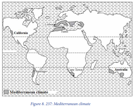
Characteristics of Mediterranean climate
– The average temperature of the coldest month is between 4.4°C and 10°c. That
of the hottest month is between 21° C and 27°c.
– The mean annual temperature ranges are between 11°and 17°c.
– The average annual precipitation is between 350 and 750 mm.
– There is rain in winter while the summers are dry.
– Below there is an example of Algiers (Algeria) weather station:
– Algiers (Algeria) weather station
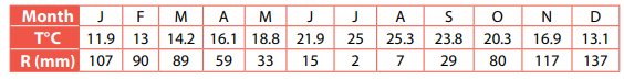
Temperate Maritime Climate
This type of climate is found between 40° and 65° N and S of the equator. These are
regions to the West of continents.
It is mainly found in Western Europe including Great Britain, North Western France,
Germany, Denmark, Holland, Belgium and Norway.
In North America, it is found along the West coast up to 60° N of the equator. It
borders the Sub-Arctic climate of Canada and Alaska. In Europe, it extends along the
west coast of Norway to 68° N.
In the Southern Hemisphere, it is found to the Southwest coast of Chile, Southeast
coast of Australia, the islands of Tasmania and New Zealand.
Below there is an example of Brest (France) weather station:
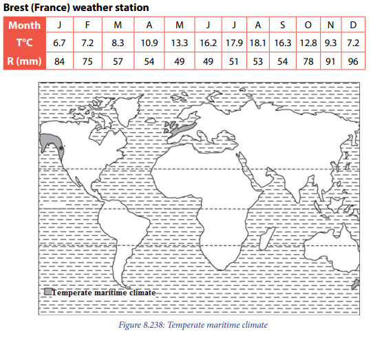
Characteristics of Temperate Maritime climate
– Temperatures are influenced by the warm Ocean currents.
– This climate has cool summers and mild winters.
– The annual range of temperature is about 7° C.
– Average temperatures in summer are between 15° C and 18° C. Winter
temperatures range between 11° and 17° C.
– In Europe, the lowlands receive an average precipitation of 500 mm to 850
mm. On the windward side, it is between 2500 mm and 3750 mm.
Continental Temperate climate
This type of climate occupies a large part of the United States of America. In Europe, it is found in Romania and Bulgaria. It occupies the lower Danube Valley. In Eastern Asia, it is found in North China bordering the yellow Sea, North and South Korea, and Northern Honshu in Japan.
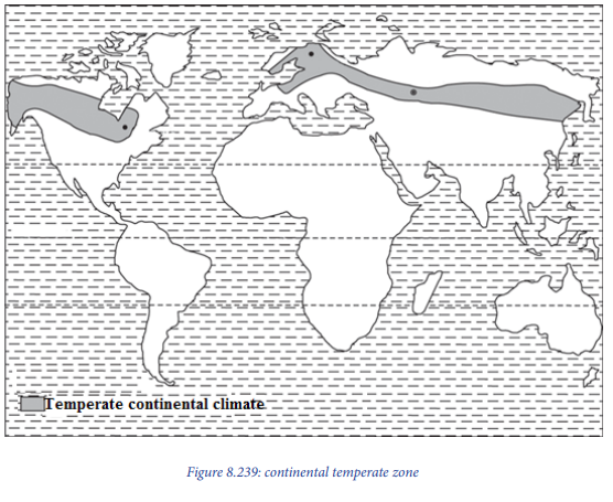
– Temperate continental climates are found on continents in the Northern
Hemisphere between 40o-70o
– Climate in these areas is controlled by the fact that they are not located near
Oceans where temperatures are moderate.
– Temperate continental climates are also called micro thermal climates, because
they are located away from the Oceans. These climatic zones experience the
extremes of temperatures.
– Summers are warm and can be very humid while winters are cold with
snowstorms and blustery winds.
– The annual average temperatures are around 100 C.
8.4.3. Cold zone
Polar and Tundra climate
The Tundra climate is found in the northern hemisphere beyond 60° N of the equator. These are areas to the North of Asia and Canada. It also occurs on the coast lands of Greenland. Polar climate is found in Greenland, interior of Iceland and in the Antarctica.
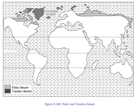
Characteristics of Tundra climate
– The average annual rainfall is 250 mm.
– Precipitation is in the form of snow in winter and rainfall in summer.
– Humidity is low because of low temperatures.
– Winter temperatures are low. They range from - 29°c to 4°c. Summer
temperatures average about 10°c.
– Vegetation consists of mosses, lichens and dwarf trees and shrubs. It is called
tundra vegetation.
Characteristics of Polar climate
– Temperatures are always low. They are below 0°c, which leads to snow.
– Precipitation mainly occurs in summer. It averages between 100 mm and 250
mm.
– Winters are associated with one continuous night. Summers are one continuous
day.
– Blizzards are common. These are snowstorms with high winds. Visibility is low.
– There is hardly any vegetation. This is because of snow and ice cover.
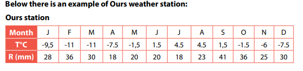
Mountain climate
This type of climate is found in the mountain ranges of the world. These include Mt. Kenya, the Ethiopian Highlands and the Alpine ranges of Europe. Others are the North Western part of Rwanda, especially over volcanic region, the Andes of South America and the Rockies of North America.
Characteristics of Mountain climate
– High rainfall on the windward slopes. It is less on the leeward slopes.
– Orographic rainfall is received.
– Pressure and temperature decrease with altitude.
– But if the mountains are high enough, there is a height at which maximum
precipitation occurs and above which it decreases.
– It is also characterized by strong local winds (mountain and valley breezes).
Application activity 8.4
a. Draw a world sketch map and on it mark and label the world climatic
zones.
b. Describe the characteristics of each climatic zone shown on that world
sketched map.
8.5. Influence of climate on human activities
Learning activity 8.5
“People in North Western part of Rwanda grow Irish potatoes, while people in
Southern Rwanda grow cassava and those of Eastern Rwanda grow bananas.
Again, in some regions of Rwanda tea is grown as a cash crop while other does
not”.
Hence explain how those crops grown are influenced by climatic conditions in
each part.
Climate influences the distribution of population. This is because of temperature
conditions, amount of precipitation and length of crop growing season.
The relationship between climate and human activities is summarized below:
– Human activities in equatorial regions: Heavy rainfall and high temperatures
support growth of forests. The main human activities are lumbering and
agriculture. Lumbering is the cutting down of trees and making them into
timber. Crops such as coffee do well in this type of climate.
– Human activities in savanna climate: This type of climate is good for
agriculture and dairy farming. There is enough grass for the animals. Growing
of vegetables is done in this type of climate.
– Human activities in desert climate: The high temperatures and low rainfall
are not supportive for agriculture. Animal keeping is also not well developed
only camels, goats and sheep are kept in such type of climate. Furthermore, it
is only around the oases that some farming is done. An oasis is a fertile spot
in the desert where water is found. Growing of crops is done by irrigation.
However, mining activities are done in some deserts for instance gold is
extracted in West Australia; diamonds in the Kalahari and petroleum in Algeria,
Libya, Saudi Arabia, Kuwait, Iran and Iraq.
– Human activities in temperate climate: This type of climate is suitable for
agriculture and livestock keeping. Most developed countries are in this type of
climate. These zones have high population.
– Human activities in polar climate: The main activities in this zone are the
fishing and hunting. Few people are found here.
Application activity 8.5
“Most of entrepreneurs look for climatologists and meteorologists to advise them
when locating their firms”, Discuss the statement.
END UNIT ASSESSMENT
1. With aid of diagram describe the structure of atmosphere.
2. To what extent atmosphere plays a considerable role in regulating/
control negative effects of solar radiation?
3. Visit a weather station near your school to identify instruments used to
measure and record weather conditions.
4. (a) Briefly describe the characteristics of Rwandan climate,
(b) Explain the factors influencing the climate of Rwanda.
5. “Human activities depend upon climate and weather conditions of an
area” with relevant examples in Africa, support this statement.