UNIT 9 GLOBAL DRAINAGE SYSTEMS
UNIT 9: GLOBAL DRAINAGE SYSTEMS
Key unit competence:
By the end of this unit, I should be able to investigate the economic importance of
global drainage systems and the reasons for their conservation
Introductory activity
1. Do research using the internet and other geographical resources to
explain the following drainage terms:
a. Drainage system, a river and associated terms like river discharge, river
velocity, catchment area, a river divide and a river basin.
b. How does a river erode, transport and deposit its load?
2. Referring to the nearest river or Lake in your local environment or near
your school explain the usefulness of drainage systems.3. Discuss why there is need to conserve drainage systems.
9.1. River system
Learning activity 9.1
1. Do research and explain the types of rivers and the river profiles.
2. What do you understand by the concept of a river profile?
9.1.1. Definition of a river and the associated terms
A river is a natural wide flow of water across the land. The water originates from a
known source and empties into a sea, lake or another river. The river flows along a
channel, whose water volumes increases as the river goes downstream.
The following terms are used in describing a river channel
• Discharge: is the amount of water originating from precipitation which
reaches the channel by surface runoff, through flow and base flow. Discharge
is, therefore, the water not stored in the drainage basin by interception, as
surface storage, surface moisture storage or groundwater storage or lost
through the evapotranspiration.
• River Velocity: Is the speed at which the water flows through the channel. It is
less at the sides and bed than at the center of a river. The velocity also depends
on the river’s gradient.
• A river Basin: Is an area of land drained by a river and its tributaries. Its
boundary is marked by a ridge of high land beyond which any precipitation
will drain into adjacent basins. This boundary is called a watershed.
• A river divide: This is the crest of the upland or mountain from which the
streams flow down the slopes on both sides to their journey.
• River width: This is the distance across the surface of a river from one bank to
another bank.
• River depth: Is the vertical distance from the river surface down to its bed.
• River gradient or slope: Is the angle of slope between the vertical drop in
relation to the horizontal distance of a river.
• Catchment area: A river catchment is an area from which a river derives its
water. This can be an upland or mountain.
9.1.2 Types of rivers
There are different types of rivers. The following are the main types:
• Perennial River: This is a river with water flowing permanently in its channel
throughout the year.
• Intermittent River: This is a semi-permanent river which stops flowing at some
point in space and time. It stops to flow every year or at least twice every five
years.
• Ephemeral River: This is a seasonal river that flows only when there is heavy
rain or when snow has melted.
9.1.3 The river system: The work of a river
As a river moves from its source to its mouth, it performs the triple function (three
phases) of erosion, transportation and deposition. The following is the work of a
river:
a. River erosion: This involves the removal of different soils and rock particles
of varying sizes from the river’s bed and banks. Erosional work of rivers
depends on the channel gradient, the volume of water, the river’s velocity,
water discharge and the sediment load (amount of eroded material). The
river erosion is at its peak when the river passes through a steep gradient
where the speed of flow is great. The river erodes its bed and channel in the
following ways:
• Hydraulic action: This is the process by which fast flowing water enter into the
cracks on the river bed and channel sides. The repeated friction and pressure
of water force cracks to widen and finally erode weaker rocks.
• Solution or corrosion: This is the removal of rocks like salt, limestone etc. that
are soluble in water. Such rocks dissolve in water and are carried in solution
form.
• Abrasion or corrasion: This is the erosion of the river’s bed and channel sides
by the rolling action of materials or river load against rocks. The heavier rocks
transported in water rub and slid against the bed and channel rocks eroding
them as they are transported downstream.
• Attrition: This is the erosion of the river’s load by the load itself. The rock
particles carried by a river collide against each other and break into smaller
particles.
b. River transportation: Rivers transport refers to the carrying away of eroded
material downstream. Rivers transport their load in the following ways:
• Solution: This is the downstream movements of soluble material like salt,
carbonates dissolved in water.
• Suspension: This is where the light particles of plants, soil and rocks are carried
away while floating or maintained within the turbulence flow of water.
• Saltation: This occurs when the load carried by the river is transported in a
series of short jumps or hops. It involves the transportation of particles which
are not too heavy but cannot remain suspended in water. Materials such as
pebbles, sand and gravel are temporarily lifted up by the river currents and
then dropped back along the bed in a hopping motion. Such movements are
known as hydraulic lift.
• Traction: This is where large and heavy materials are rolled, pushed and
dragged downstream by the force of moving water. Such materials include
rocks, pebbles and boulders.
c. River deposition: This refers to the situation where a river fails to transport
its load. The river, then drops its load due to the reduction in its energy. The
heavy load is selectively deposited first, while the fine and lighter particles
are deposited last. The material deposited by a river is referred to as alluvium.
9.1.4: The river profile and its characteristics
A river profile is a section through the river channel from its source to its mouth or
from one bank to another. There are two types of river profile: cross profile and long
profile.
• Cross profile
This is also known as the transverse section of a river. It is the shape a river assumes
from one river bank to the other. It develops as a result of down-cutting and lateral
cutting of the riverbed and banks by water currents. This undercutting makes a
section of a river valley, have different shapes and forms. For example, in the upper
valley, vertical erosion produces a steep “V”-shaped valley. However, this depends
on the rate of erosion and weathering taking place on the valley sides.
In the middle and lower stages, the river valley begins to become shallow and widedue to increased lateral erosion. The valley assumes a “U” shape.
• Long profile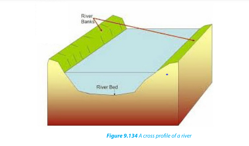
This is the longitudinal section of a river. It contains a variety of erosional and
depositional features. Based on its distinctive characteristics, the long profile of a
river is divided into three stages (upper/youthful, middle/mature and lower/oldstages) known also as normal cycle of erosion.
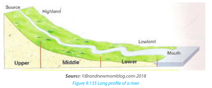
The following are the characteristic features of successive stages:
• Youthful stage: This is also known as the torrent or upper stage of a river.
- The gradient at this stage is steep. Therefore, the river flows very fast.
- The main river gradually deepens its valleys.
- The main type of erosion is vertical. The valleys are narrow and deep.
- The features found in this stage include gorges, rapids and waterfalls. .
• Mature stage: it is also known as the valley stage or the middle course.
- This is the stage between the upper and lower courses of the river.
- The gradient is reduced. Therefore, the speed of the water is also reduced.
- The main type of erosion is lateral. Therefore, the river begins to widen its
channel. There is also some deposition of materials or sediments.
- More tributaries join the river, leading to a large volume of water.
- The river begins to meander or follow a winding course.- The features found in this stage include cliffs, slip-off slopes and bluffs.
Old stage: This is also known as the plain stage or lower course or senile
stage.
- The gradient of the river is very gentle. Therefore, the river flows slowly.
- There is a lot of evaporation at this stage.
- The valley is shallow, wide and flat.
- Seasonal floods occur.
- There is a lot of deposition of sediment on its bed.
- The features found in this stage include ox-bow lakes, deltas, floodplainsetc.
Application Activity 9.1:
1. Explain the major work of a river.
2. Describe the characteristics of a river that you observe in your localenvironment and how that river affects the environment around.
9.2. Formation of the major landforms associated with a river profile
9.2.1 Formation of landforms in youthful stage
Youthful stage is the first stage of a river near its source. This stage is characterized by
a steep gradient, fast flowing water, vertical erosion etc. There are several landforms
that are created in this stage especially due to vertical erosion and the nature of the
gradient. The landforms like waterfalls and rapids, potholes and plunge pools are
the main landforms:
i. Waterfalls and rapids
Waterfalls abrupt movements of water or simply sudden descents of water due to
abrupt breaks in the longitudinal course of the river. Water falls are mostly caused by
variations in the relative resistance of rocks, relative difference in topographic reliefs,
fall in the sea level and related rejuvenation and earth movements. A waterfall,
therefore, is a vertical drop of a big volume of water from a great height along theprofile of a river.
Rapids are alternate breaks along the river’s profile. Rapids are smaller than
waterfalls. Generally, they are found upstream from the main falls, and are alsofound independently
ii. Potholes and Plunge pools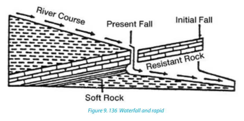
These are kettle-like and cylinder-shaped depressions in the rocky beds of the river
valley. They are circular depressions cut at the bed of the river by fast flowing water.
They are formed due to saltation and traction movement of large pebbles and
boulders on resistant rocks. Plunge pools are formed when pot holes are furtherwidened and deepened by circular and fast movements of water.
9.2.2. Formation of landforms in mature stage
A mature stage of the river is the middle stage of a river’s course where the gradient
is lower and where the river begins to flow slowly as it widens its channel.
The following are the major landforms:
i. River valleys: The valleys carved out by the rivers are significant erosional
landforms. The shape and dimension of fluvial originated valleys change
with the advancement of the stages of fluvial cycle of erosion.
ii. Gorges and Canyons: Are very deep and narrow valleys with steep sides/
slopes that are wall-like. They are formed when water falling over the hard
rock, undercuts the rock leaving it hanging. The hanging rocks may cause
water to retreat upstream leaving behind a narrow and deep sided valley
iii. Alluvial fans: These are fan-shaped deposits of coarse alluvium. They are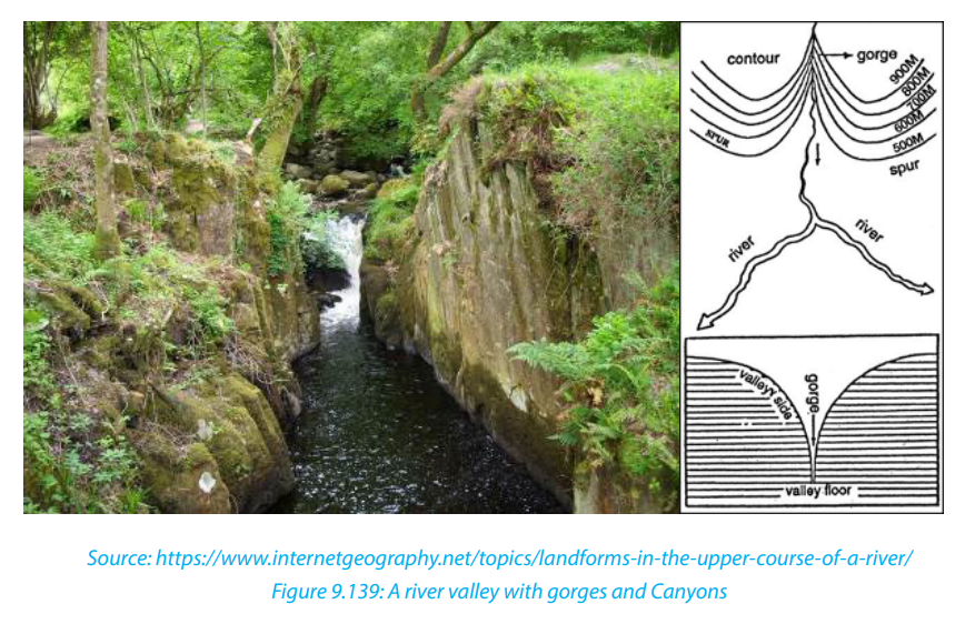
formed when a fast flowing river loses its velocity when it enters the gentle
slope. The river immediately deposits its load composed of course materials
especially rocks, boulders and bigger pebbles. The deposits are laid in formof a fan, hence the name, “alluvial fan”.

iv. River Benches: These are step-like flat surfaces on either side of the lowest
valley. The benches or terraces formed due to differential erosion of alternate
bands of hard and soft rock beds are called structural benches or terraces
because of lithological control in the rate of erosion and consequent
development of benches.
v. River terraces: The narrow flat surfaces on either side of the valley floor are
called river terraces which represent the level of former valley floors and theremnants of former (older) flood plains.
9.2.3. Formation of landforms in old stage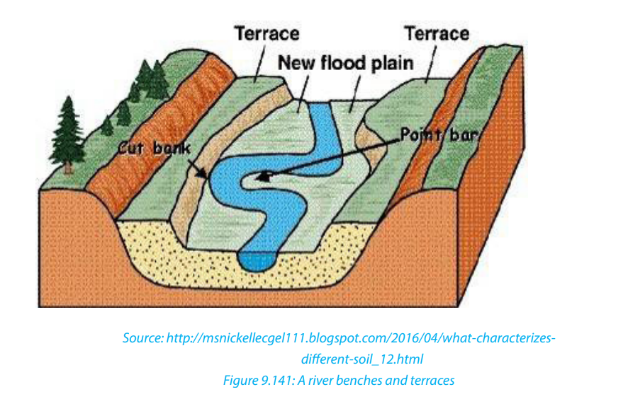
The lower or old stage of river is the last stage where a river nears its destination. This
stage is characterized by large deposits along the river’s bed and channel. The large
deposition is a result of increased lateral erosion, very slow movement of water and
very wide river channel. In this stage the river drops its load due to the reduction
in its energy. The material deposited by a river is called alluvium. River deposition
results into the formation of the following features:
i. River meanders: River meanders are the bends of the rivers. The bends of
sinuous rivers have been named meanders on the basis of Meander River
of Asia Minor (Turkey) because it flows through numerous bends. Each
bend of the meander belt has two types of slopes of valley sides. One side
is characterized by concave slope while the other side of the meander
belt is characterized by convex slope. The convex or slip off slope receives
deposition mostly of sands and gravels and alluvium at other times.
Therefore, the bank of maximum deposition is also called a slip-off slope.
The concave slope is a bank of maximum erosion or undercutting. It issteeper than the slip-off slope.

ii. An Ox-bow lake: This is a horse-shoe lake formed due to stagnation of water
in the abandoned meander loop. Ox-bow lakes are formed when a river
develops very pronounced meanders in the flood plains. As erosion and
deposition continues on the river’s banks, the neck of the meander is cut off
and the water flow straight by-passing the old meander. The abandoned orcut off meander therefore becomes an ox-bow lake.
iii. A Flood plain: This is a very gentle low-lying plain of alluvial deposits on
a floor of a river valley. It is formed where a river flows in a meandering
way. As a river swings back and forth across the valley, it widens its valley
floor. The valley becomes so broad that the meanders swing freely without
touching the valley sides. When the level of water rises during the flood
time, all the plain along the river valley becomes flooded. The river thendeposits its alluvium in the plain.
iv. Levees: These are raised river banks made up of alluvial deposits. Levees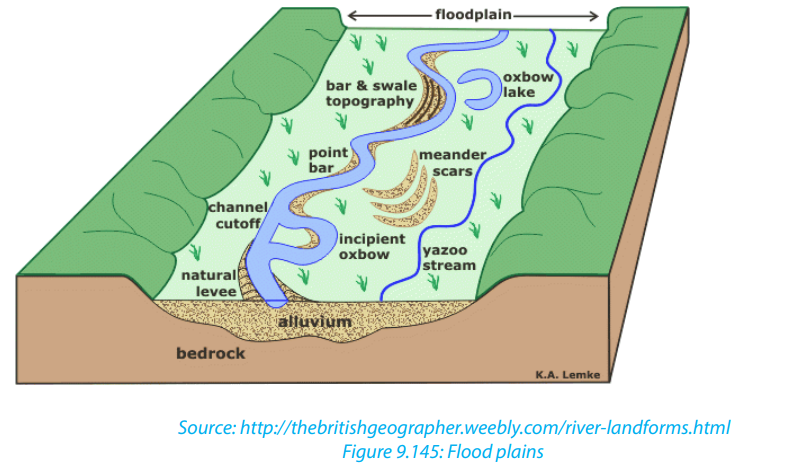
are formed when a river deposits its load along its banks during flooding.
Slightly coarse materials are deposited on the banks, while finer alluvium
is transported further onto the flood plains. With time, accumulation of
coarse material raises the banks of the river to form levees. During the dry
seasons, when the river retreats into its channel, deposition are left both
on the river’s bank and on its bed. This leads to the formation of raised riverbeds and banks.
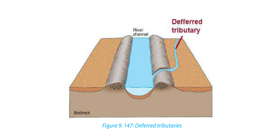
v. Deferred tributaries: These are small tributary rivers that flow alongside
the main river. They are formed when raised levees stop tributaries from
joining the main stream. As a result, such tributaries, flow parallel to the
main river until they encounter a break in the river bank where they now
can join the main stream. They are thus referred to as deferred tributaries or
Yazoo streams. The point at which they join the main stream is referred to
as a deferred confluence. The tributary flows to the main channel and finallybreak through levees and join the main channel.
vi. Braided channel: This is a wide and shallow channel where a river breaks
into a series of interconnecting distributaries separated by sandbanks and
islands of alluvium. It is formed in the middle or old stage of a river where
the valley is wide and gently sloping. The river carrying a large load flows at
a low velocity, fails to transport its load and finally deposits its load on the
bed. Gradually, the river bed is raised and the deposits divide the flow ofwater into small tributaries and distributaries.
vii. Delta: A delta is a low-lying swampy plain of alluvium at the mouth of a river.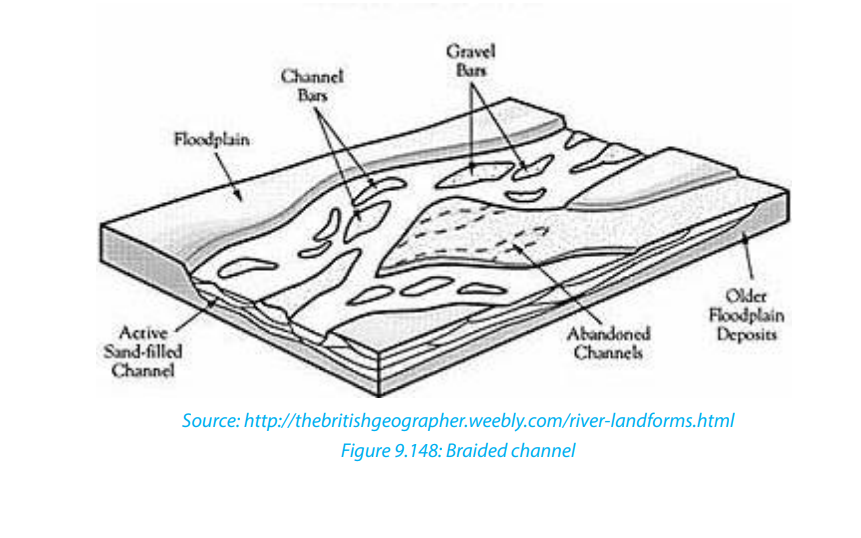
A delta forms when a river fails to push all its load into the sea or mouth
but deposits these into its mouth. The deposits divide the river’s mouth into
tributaries and sub tributaries. The deposits gradually become colonized by
various types of plants and forms a triangular shaped mouth of a river. This
is called delta. The growth of a delta. The river split up into several separate
channels in much the same way as river braids. Deltas are classified into two
categories depending on the shape and growth where there are growing
deltas and blocked deltas. They include the following:
• Estuarine deltas,
• Arcuate deltas,
• Bird’s foot deltas.
- Estuarine delta: This is a submerged mouth of a river. It is a delta formed from
materials deposited in the submerged mouth of a river. This takes the shape
of the estuary. Examples are the Zambezi Estuary in Mozambique, and Volta
Delta in Ghana.
- Arcuate delta: this is a triangular and convex shaped delta. It is formed by a
river with many distributaries transporting materials. It occurs where off-shore
currents are strong enough to round the seaward edge of the delta. Examples
are Sondu Delta in Kenya, Nile Delta in Egypt and Amazon Delta in Brazil.
- Bird’s foot delta: This is a delta that looks like the claws of a bird’s foot. It is
also known as digitate delta. It is formed when a river transporting large
load of mainly fine material enters into water that has low energy wave. The
distributaries extend from the shore into the open water. Examples are OmoRiver Delta on Lake Turkana and Mississippi Delta in the USA.
Application activity 9.2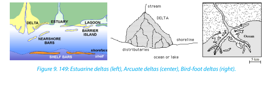
1. Visit the nearest rivers and do the following:
i. Identify the landforms formed along a river.
ii. Explain the importance of the above landforms to the local people.
2. Describe the relationship between landforms in the lower stage of ariver and human activities.
9.3. River capture and river rejuvenation
Learning activity 9.3
Make a research and establish the effects of the river capture and River
rejuvenation.
9.3.1. River capture
iii. Definition of river capture
River capture refers to the diversion of headwaters of a weaker river system into
a system of the stronger neighboring river. It is also referred to as river piracy. The
point of capture is known as “elbow of capture”. This point is usually found near
the dry valley or misfit stream. A misfit stream is the river whose water has been
beheaded or diverted into another stream. It contains very little or no water at all
and is not therefore fit to be in that river. This is why it is called misfit stream. Beyond
the misfit stream is a valley that no longer contains water. It is only covered by old
alluvial deposit. This is called a dry valley.
Features of river capture
There are four major features of river capture: elbow of capture, cols or wind gaps,misfit or under fit streams and dry valleys.
iv. Causes of river capture
A river capture can be caused by headward erosion, lateral erosion, or coalescence
of meanders. The following are the causes of river capture:• The presence of a river with a larger volume of water compared to its neighbourFor river capture to take place, the following conditions are necessary:
(the weaker river). The stronger river erodes its valley faster by vertical erosion
compared to its neighbour.
• The presence of soft and easily eroded rocks in the valley of a stronger river
• Earth movements like faulting, folding, warping and volcanicity on the valley
of a stronger river can also cause river capture
• Change in base level as a result of river rejuvenation. A fall or rise in a river’s
base level can cause river capture• There must be a powerful river or pirate stream and a misfit stream flowing• The pirate river must be flowing over easily eroded rocks compared to those
adjacent or parallel to each other.
• The pirate river must be flowing over a much steeper valley than the misfit or
beheaded stream
• The pirate river must be having more active head ward erosion compared toits neighbouring river
of its neighbour
v. Effects of river capture
The following are the effects of river capture (after the occurrence of river capture):• The volume of water in the pirate stream increases;9.3.2. River rejuvenation
• The capturing/beheading river becomes bigger and more stronger than it was
before capture;
• The beheaded stream having lost its waters contains very little water and
almost dries off (a misfit river);
• The pirate river develops an elbow of capture. This denotes a sharp change in
the direction of a river course (at the point of capture);
• The valley of the beheaded stream below the point of capture becomes dry
and hence the name, “wind gap”;
• Incision of the pirate river near point of capture. This valley becomes wider dueto increased vertical erosion (head ward erosion).
i. Definition of river rejuvenation
River rejuvenation is the renewed erosive activity of a river. It is an acceleration of
erosive power of the fluvial process of rivers. Rejuvenation length is the period of the
cycle of erosion. For example, if the cycle of erosion is passing through senile stage
(old stage) characterized by gentle channel gradient, sluggish river flow and broad
and shallow alluvial valleys, after rejuvenation (caused either due to substantial fall
in sea level or due to uplift of landmass) the cycle is interrupted and is driven back
to juvenile (youth) stage characterized by steep channel gradient and accelerated
valley incision.
There are three types of rejuvenation as follows:a. Dynamic rejuvenation: It is mainly caused by uplifting in the landmass,ii. Causes of river rejuvenation
tilting of land area and lowering of the outlet.
b. Eustatic rejuvenation: This occurs because of changes in sea level due to
diastrophic events (subsidence of sea floor or rise of coastal land) and
glaciations causing fall in sea level.
c. Static rejuvenation: Its main causes are decrease in the river load, increase
in the volume of water and consequent stream discharge due to increasedrainfall, increase in water volume of the main river due to river capture.
River rejuvenation is caused by the following:
• A fall in base level or fall in the level of the sea.
• Earth movements involving uplift, down faulting
• River capture which may cause an increase in the volume of water (river
discharge)• Change in rock resistance
iii. Effects of river rejuvenation on the landscape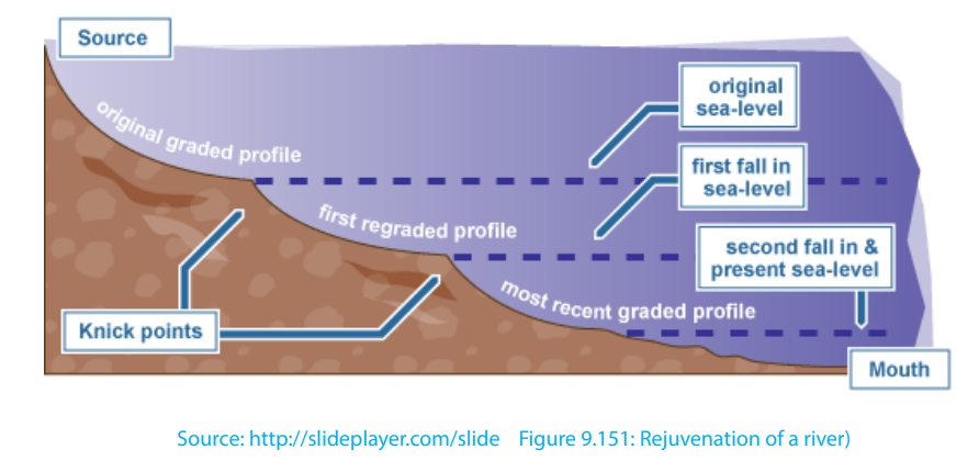
River rejuvenation produces several features as follows:
• Knick point: This is a break of slope in the long profile of a river valley. It
indicates the point where rejuvenation started. Knick points are associated
with rapids and water falls.
• Paired terraces: These are steps or bench-like river valleys on both sides of a
rejuvenated valley. They are marked by old alluvial deposits laid down before
river capture occurred. It is therefore a part of the former flood plain valley that
is above the present river level.
• Incised meanders: An incised meander is a curved bend of a river that has
been incised or cut into the land surface so that a river now winds between
steep valley walls. Incised meanders develop from an already meandering
river.
• Ingrown meanders: These are incised meanders with asymmetrical steep
valley sides. They develop on resistant rocks and where the base level fallsgradually and the meander shifts gradually and laterally
• Valley within a valley: This is also referred to as a rejuvenation gorge. These
are steps at the opposite sides of a rejuvenated valley. They form where
rejuvenation was very rapid with a large fall in base level. The river flows in a
deep channel within paired terraces that were once the remains of the floodplain.
Application Activity 9.3: 1.Observe the following picture and answer the questions that follow
i. Explain the factors that favour river capture.
ii. Describe the effects of river capture on the above figure.
2. Visit your local area, and identify a typical example of a rejuvenated riverand explain its causes.
Source: http://sageography.myschoolstuff.co.za/wiki/grade-12-caps/geomorphology/fluvial-procesrive
9.4. Drainage in the world
Learning activity 9.4:
Use internet and other geographical resources and describe the types ofdrainage patterns.
9.4.1 Drainage pattern in the world
A drainage pattern is the way in which a river and its tributaries arrange themselves
within their tributaries and distributaries. Most patterns evolve over a lengthy period
of time and usually become adjusted to the structure of the basin. The development
of the drainage patterns is influenced by:
• The gradient of the slope
• The nature of the bedrock. This is in terms of how resistant the rock is.
• The structure of the basement rock.
9.4.1. Types of drainage Patterns
There is no widely accepted classification of drainage, because most drainage
patterns are descriptive. Drainage patterns are however grouped into patterns
independent of structure, and those dependent on structure. There are also some
patterns apparently unrelated to structure:
i. Patterns dependent of structure
• Trellised drainage or rectangular drainage pattern are well adjusted to
the geological structures. In areas of alternating resistant and less resistant
rock, tributaries will form and join the main river at right-angles. Sometimes
each individual segment is of approximately equal length. The main river,
is also called a consequent river because it is a consequence of the initial
uplift or slope and flows in the same direction as the dip of the rocks. The
tributaries which develop, mainly by headward erosion along areas of weaker
rocks, are called subsequent streams because they form at a later date than
the consequents. Such patterns are developed in the area of simple folds
characterized by parallel anticlinal ridges alternated by parallel synclinal
valleys.
• Radial drainage pattern: This is a system where rivers/streams flow in a
circular way, outwards a central body. It develops in areas where the rocks have
been lifted up into a dome structure. Streams which diverge from a central
higher point flow in all directions. Dome structures, volcanic cones, residual
hills, small tablelands, mesas and buttes, and isolated uplands can favour thedevelopment of ideal radial pattern.
• Centripetal drainage pattern or inland drainage pattern: This is the
opposite to the radial drainage pattern because it is characterized by
the streams which flow and converge at a point which is generally a
depression or a basin. This pattern is formed by a series of streams which
after emerging from surrounding uplands converge in a central low land
which may be a depression, or a basin or Crater Lake. The best examples
are found on Lake Victoria with rivers like R Nyando, River Akagera, River
Mara and River Katonga
• Annular drainage pattern: This is also known as “circular pattern”,
is formed when the tributaries of the master consequent streams are
developed in the form of a circle. Such pattern is developed over a mature
and dissected dome mountain characterized b y a series of alternatingbands of hard and soft rock beds.

• Herringbone drainage pattern: This is also called rib pattern (like the
rib bones of human beings) is developed in mountainous areas where
broad valleys are flanked by parallel ridges having steep hillside slopes.
The longitudinal consequent streams, as master streams, are developed in
the longitudinal parallel valleys while tributaries, as lateral consequents,
after originating from the hill slopes of the bordering parallel ridges jointhe longitudinal consequents almost at right angles.

ii. Patterns independent of structure
• Dendritic drainage pattern: This derives its name from the Greek word
Dendron, meaning a tree, this is a tree-like pattern in which the many tributaries
(branches) converge upon the main river (trunk). It is a common pattern which
develops in basins having one rock type with no variation in structure.
• Parallel drainage pattern: This occurs on newly uplifted land or other
uniformly sloping surfaces which allow rivers and tributaries to flow downhill
more or less parallel with each other (e. g. rivers flowing south-eastwards fromthe Aberdare Mountains in Kenya).
Dendritic drainage patterns Parallel drainage pattern
iii. Patterns apparently unrelated to structure
• Barbed d r a i n a g e pattern: This is a l s o c a l l e d hooked drainage
p a t t e r n , is a rare kind of drainage pattern formed when the tributaries
flow in the opposite direction to their master streams. The tributaries join
their master streams in hook-shaped bends. Such a pattern is generallydeveloped due to river capture.
• Pinnate drainage pattern: This is developed in a narrow valley banked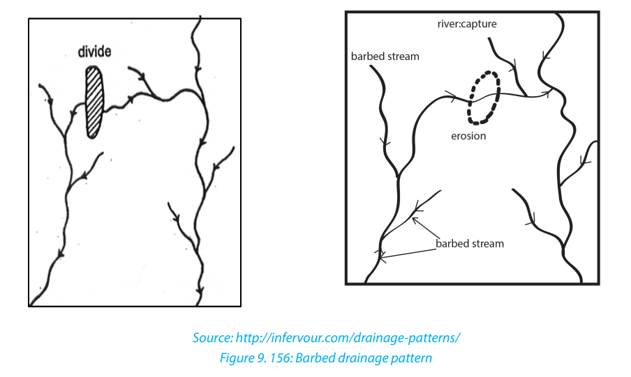
by steep ranges. The tributaries originating from the steep sides of parallel
ridges join the longitudinal master consequent occupying the valley atacute angles.
9.4.2. Superimposed and antecedent drainage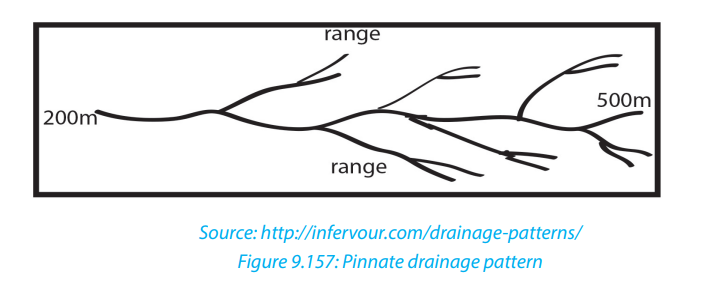
i. An antecedent drainage:
This is a drainage made of streams that maintain their original course and pattern
despite the changes in underlying rock topography. Antecedence is when the
drainage pattern developed before such structural movements as the uplift or
folding of the land, and where vertical erosion by the river was able to keep pace
with the later uplift. A stream with a dendritic drainage pattern for instance, can
be subject to slow tectonic uplift. However, as the uplift occurs, the stream erodes
through the rising ridge to form a steep-walled gorge. The stream thus keeps its
dendritic pattern even though it flows over a landscape that will normally produce
a trellised drainage pattern.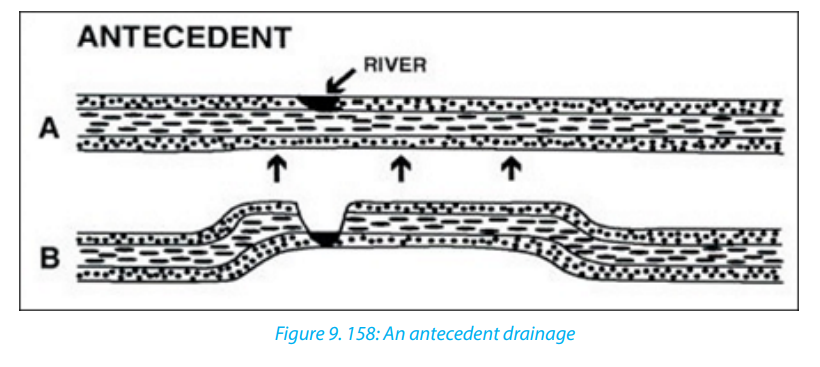
ii. A superimposed drainage:
This kind of drainage pattern seems to have no relationship to the present-day
surface rocks. Superimposed pattern is a drainage that formed over horizontal
beds that overly folded and faulted rock with varying resistance. The stream erodes
through the underlying horizontal beds, and retains its course and pattern despite
changes in the underlying rock. The stream erodes a gorge in the resistant bed andcontinues its flow as before.
9.5. Impact of rivers
Application activity 9.4
1. Visit any nearby river and identify its pattern of drainage and explain how
this pattern was developed.
2. Describe the formation of antecedent and superimposed drainage.
Learning activity 9.5
Describe the developmental activities that are done along any river valley in
your locality or in the world
9.5.1 Impact of rivers
Rivers play an important role both to human beings and the surrounding
environments. Rivers can also negatively affect people and the surrounding
environments.
The rivers and riverine landforms influence human beings positively:• Rivers provide water for various uses such as domestic, industrial uses, drinkingNegative effects
by animals.
• Navigable rivers provide natural route-ways used for transportation.
• Rivers provide water for irrigation especially in areas of low rainfall. This
promotes agriculture, hence increasing food production.
• Waterfalls provide natural sites for the production of hydroelectric power.
Examples are: waterfall between lakes Burera and Ruhondo, River Rusizi in
Rwanda, River Tana in Kenya, River Volta in Ghana, water falls along River Nile,
etc.
• River Ria, estuaries and deltas are deep and sheltered, hence they promote the
development of ports like Alexandria on the Nile delta.
• Building materials such as sand, gravel and pebbles are obtained from river
beds and valleys.
• Some rivers have spectacular features such as waterfalls, gorges and canyons
which attract the tourists. For example, Rusumo falls on river Akagera in
Rwanda.
• Alluvial deposits in some river valleys are a source of valuable minerals such
as alluvial gold for example in Miyove valleys in Northern Province of Rwanda.
• Building materials such as sand, gravel and pebbles are obtained from
riverbeds and valleys.
• Flood plains and deltas contain fertile alluvial soils which have been exploited
for agriculture. Example is the Nyabarongo river valley, Nile valley in Egypt etc.
• The livestock activities are mostly developed near water bodies where drinking
and green vegetation water is available throughout the year
The rivers and riverine landforms influence human beings negatively:• Some large rivers form barriers to communication between communities of
the same culture.
• During flooding some rivers cause destruction of property and loss of human
life.• Some river water may act as a medium for the spread of water borne diseases,for example, Malaria, Bilharzia.
• Some rivers harbour dangerous animals such as crocodiles and9.5.2. Case studies of rivers: Major rivers of the worldhippopotamuses. These at times attack human beings and destroy crops.
The following are the major rivers of the world.
i. Amazon River is the largest river in the world. It is found in South America.
It is 6,400 km long. It has a drainage basin of 7,050,000 square km. It also
carries more water than any other river in the world. It can reach a width of
200 km. The Amazon River flows across North Brazil.
ii. The Nile is the longest river in the world. It is 6,853 km long. Its drainage
basin covers 3,400,000 million square km. The source of River Nile is Lake
Victoria. It flows into the Mediterranean Sea. The river passes through
Uganda, South Sudan, Sudan and Egypt.
iii. Ganges River: it is a trans-boundary river o Asia which flows through the
nations of India and Bangladesh. The 2,525 km (1,569 mi) river rises in the
western Himalayas in the Indian State of Uttarakhand, and flows south and
east through the Gangetic of North India into Bangladesh, where it empties
into the Bay of Bengal. It is the third largest river in the world by discharge.
The Ganges is the most sacred river to Hindus. It is also a lifeline to millions
of Indians who live along its course and depend on it for their daily needs. It
is worshipped as the goddess Ganga in Hinduism. The Ganges was ranked
as the fifth most polluted river of the world in 2007. Pollution threatens not
only humans, but also more than 140 fish species, 90 amphibian species
and the endangered Ganges river dolphin.
iv. Congo River is the second longest river in Africa. It is 4,700 km long. It has
a basin of 4,000,000 square km. It is made up of two tributaries. These are
Lualaba and Luapula. It flows through northern and western Democratic
Republic of Congo (DRC) into the Atlantic Ocean.
v. The Niger River is the third longest river in Africa. It is 4,180 km long. The
river begins in Guinea and runs east through Benin, Guinea, Mali, Niger, and
Nigeria. Its main tributary is the Benue River.
vi. The Mississippi River is found in North America. It is 3,734 km long. Its
basin is 2,981,076 square km. The source of the river is Lake Itasca. It passes
through mid-United States to the Gulf of Mexico.
vii. Missouri River is the longest river in North America. It is 4,130 km long.
The Missouri is the longest tributary of the Mississippi. The source of the
Missouri is the meeting point of Rivers Jefferson and Madison. It joins
Mississippi River at St. Louis.
viii. The Danube River begins in the Black Forest in Germany. It flows eastwards
for a distance of some 2,850 km, passing through four Central and Eastern
European capitals. It empties into the Black Sea through the Danube Delta
in Romania and Ukraine.
ix. Rhine River is 1,320 km long. It is the second longest river in Central and
Western Europe. It begins in the Swiss Alps. The Rhine flows through six
countries. These are Switzerland, Liechtenstein, Austria, Germany, France
and the Netherlands. It empties into the North Sea at Rotterdam.
x. Volga River is the longest river in Europe. It is 3,700 km long. It is located in
Central and Eastern European Russia. The source of River Volga is the Valdai
Hills to the northwest of Moscow. It empties into the Caspian Sea.
xi. Huang He/Hwang Ho/Yellow River is the third longest river in Asia. It
is 4,830 km long. Its source is the twin lakes Gyaring and Ngoring in the
Kunlun Mountains. to the northwest of Qinghai province.
xii. Chang or Yangtze Mandarin Chang Jiang is the longest river in China.
It is 6,245 km long. It rises in the Tibetan highlands to the southwest of
Qinghai Province. Western China and flowing generally Eastern through
central China into the East the river passes through one of the world’s
most populated regions. It has for many years been used as a trade andtransportation route.
9.5.2 Case Study of the Nile River in Egypt
Extract from: UK ESSAYS. (March, 2015). The importance of the Nile River.Environmental science essay
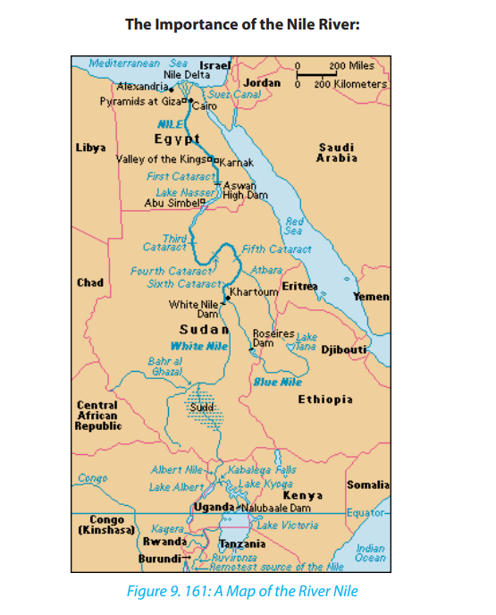
Egypt would be almost all barren deserts without the Nile. The Nile is one of the most
important things that Egypt can’t live without. No one can deny that the Nile was so
important to the pharaohs in their daily life. The pharaohs were so smart, they used
the Nile so well to help them in their life. The pharaohs used the Nile for agriculture.
The pharaoh got all the rich peasants to do the farm work on the rich lands. Most
of the ancient villagers were farmers. Egyptians grew several crops such as wheat,
barley, vegetables, figs, melons, pomegranates and vines. The most important
crop at this time was grain. The pharaohs used grain to make bread, porridge and
beer. The Grain was the first crop they grew after flooding season. Once grain was
harvested, they grew vegetables such as onions, cabbages, beans, cucumbers and
lettuce. Farmers planted fruit, trees along paths, to give shade as well as fruit. The
Egyptians grew their crops along the banks of the River Nile on the rich black soil
which was considered one of the best soils for agriculture in the world. This rich soil
was left behind after the yearly floods. This soil was ideal to grow healthy crops.
Egyptian farmers divided their year into three seasons, based on the cycles of the
Nile:
Farming was not done during the flooding season as all the fields were flooded.
Instead, many farmers worked for the pharaoh, building pyramids or temples. Some
of the time was spent mending their tools and looking for animals. The Growing
Season which starts in October, the flood waters recedes, leaving behind a layer of
black soil.
Shemu which starts in March and ends in May and called also The Harvesting
Season. The fully grown crops had to be harvested and removed before the Nile
is flooded again. It was also the time to repair the canals to be ready for the next
flood. Every June in the year, the Nile flooded. This was known “the flooding season”.
During this time the farmers mend tools or make new ones. People would go fishing
for extra food or money. To lift the water from the Nile they used a shaduf. A shaduf
is a large pole balanced on a crossbeam, a rope and bucket on one end and a heavy
counter weight at the other end. By pulling the rope it lowered the bucket into
the Nile River. The farmers then raised the bucket of water by pulling down on the
weight. He then swings the pole around and emptied the bucket onto the field.
Nowadays Egyptian are sticking to the Nile from ancient Egyptians to modern Egypt
which prove how living beside the Nile is important and living beside the Nile make
life easier.
Why the Nile River Flooded?
Rains in Africa, especially rains coming from the Ethiopian Highlands, and melting
snow caused the Nile River to flood. The Ancient Egyptians used something called
Nilometer to record how high the Nile was during the year.
The flood still continues every year. The annual flood carries dead and decaying
plants in its muddy solution. The muddy water is called silt, and silt creates excellent
farm soil. Since 1970, the Aswan Dam has controlled the annual flood of the Nile River
by holding back water, the Aswan Dam created the world’s largest man-made lake:
Lake Nasser. The water from Lake Nasser provided new fishing areas and provides
much needed water for agriculture.
Since the Nile was so important in old Egyptian history, so it’s for sure that the Nile
importance increased now much more .One of the most important thing that Egypt
gets benefit due to the Nile is the High Dam. The high dam is located in Aswan. It
was completed in 1970. It cost one billion dollar; its capacity is 5.97 trillion cubic feet.
It was built to control the flood and to obtain from it hydroelectric power and it isalso used in irrigation.
The Aswan High Dam captures water flood during rain seasons and releases the
water during times of drought. The dam also generates enormous amounts of
electric power more than 10 billion kilowatt every year. That’s enough electricity
to power one million color televisions for 20 years continuously. Unfortunately,
the dam has also several negative side effects. In order to build the dam, Egyptian
peasants had to move. To make matters worse, the rich silt that normally fertilized
the dry desert land during annual floods is now at the bottom of Lake Nasser which
lead to that the Farmers have been forced to use about one million tons of artificial
fertilizer as a substitute for natural nutrients that once fertilized the arid floodplain.
A lot of research proved that Egyptians prefer living along the Nile River because it’s
much easier for their life rather than living in the desert or away from the Nile River.
One of the most important things is using the Nile as main source for water. Water
is one of the most important things for the human body because the human body
consists of 60% of water which is a very big percentage .The health of the human
body cannot work properly without the proper hydrations of the body .we have to
drink half of our body weight in ounce every day. The water is very important for
every organ inside our body. The brain consist 85% of water, the bones consist of
35% of water, blood consist of 83% of water and the liver consist of 90% of water.
This proves how much the water is so important.
There are a lot of economical projects that were made based on the Nile River. The
first project that we are going to talk about is the high dam. As we said before, the
high dam costs 1 billion dollar and can contain 5.97 trillion cubic feet of water. The
high dam provide Egypt from south to north with high amount of electricity to run
up their machine such that television, computer, lamps and their appliances. A lot
of countries have problem for obtaining high amount of electricity like that in that
easy way. This proves how this project which was based on the Nile is so essential
now for the Egyptian and can’t live without it.
The second project that we are going to talk about is the Nasser Lake. The Nasser
Lake is one of the biggest and best artificial lakes that were made with the water of
the Nile River.
Tourists come all over the world to see this beautiful lake which was handmade by
Egyptians on the Nile river water. The lake extends for 350 miles which is about 560
kilometers and is about 6 mile which is about 10 kilometer wide. Tourists come there
to see the impressive variety of animals. There people can find variety of mammals,
reptiles and birds.
Tourist also visits this wonderful lake for fishing trip because this lake contains about
32 different fish species which is a large number.
The Third Project is Tuskha Project .This Project is capable of converting all the desert
lands in Egypt into agricultural land. The Nile played a very important role in tourism,
all tourists come all over the world to see how the Nile is great and they take a cruise
from north Egypt to south Egypt and visit all the beauty which is on the Nile. The Nile
can be used for a very important activity which is transportation. Egypt has a very
big problem which is traffic jam. This is why the government should begin to plan
how to use the Nile as a very good way for transportation. The Nile can be used in
transporting people from one city to another. The government can also use the Nile
in trading which will be very effective and will be a very good solution for the traffic
jam because most of the traffic jam is because the trucks and the big buses, so the
government should put this solution in the plan because it will help in developingEgypt to the good in the future.
In Egypt, No one can live without the Nile River because no one can live without
water this is why Nile is like the main artery of Egypt. The Nile is considered the only
weapons that protect Egypt from the upcoming water war that will destroy a lot of
countries. The Nile should be used to make project to increase Egypt economy suchas the Aswan high dam, the Nasser Lake and the toshka project.
Application activity 9.5:
Referring to any river in Rwanda like Mukungwa, Nyabarongo, Akanyaru,
Base or Akagera rivers, describe the relationship between human activitiesand the surrounding river.
9.6. Lakes, Seas and Oceans
Learning activity 9.6.
Use internet and other geographical resources to research on:
i. Types of lakes and their mode of formation,
ii. Name 10 largest seas and five largest oceans in the world.
9.6.1 Types of Lakes
A lake is a large mass of water that occupies a basin or depression on the surface of
the earth. Lakes receive water from streams, overland flow, and ground water, and
so they form part of drainage systems. Lakes may be permanent or seasonal. This
depends on the volume of water that gets in, and the amount of water that is lost.
The loss of water is through evaporation and river outlets.
Lakes are categorized according to their mode of formation. They are grouped invarious ways as follows:
• Through earth movements (tectonic lakes)
• Volcanic action (lava dammed and crater lakes)
• Erosion (erosional lakes)
• Deposition (depositional lakes)• Human activities (man-made lakes)
9.6.2 Mode of formation of Lakes
The lakes are differentiated on the basis of their mode of formation. The following
are the major modes of lakes’ formation.
a. Lakes formed by earth movements
• Lakes caused by crustal warping: These are lakes that occupy a basin-like
depression. They were formed when water occupied down warped basins
immediately after crustal warping. These lakes are also called subsidence
Lakes. Examples are Lake Chad and Lake Victoria in Africa. In Rwanda, Lakeslike Muhazi, Mugesera, Cyohoha were also formed as a result of subsidence.
• Rift Valley Lakes: These are Lakes that occupy depressions within rift valleys.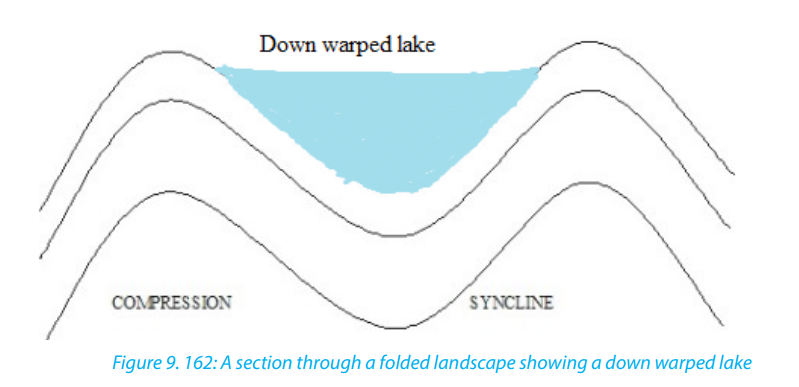
They are usually deep, elongated, and have steep sides. They are located on
the floor of a rift valley. Examples are Lakes Kivu in Rwanda, Turkana in Kenya,Tanganyika and Malawi in Tanzania
b. Lakes produced by glacial erosion and glacial deposition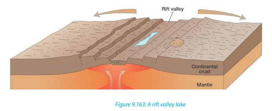
• Cirque/Tarn Lake: This is a Lake that forms in a glaciated highland. Such lake
occupies an armchair-like depression, called a cirque. During thawing (melting
of snow), water collects in circular depressions that were left behind where
large avalanches or boulders were uprooted by melt glaciers. A cirque lake,
often called a tarn, sometimes feeds a mountain river. Tarns occur on the sidesof Mount Kenya like Teleki Tarn and on Mt Rwenzori for example Stanley Lake.
• Trough Lake: This occupies an elongated hollow excavated by ice on the floor
of U-shaped valley. It is sometimes called a ribbon lake. Lake Michaelson, inthe Gorges Valley, near to Mount Kenya, is a trough lake.
• Kettle Lakes: These are small lakes that are formed in depressions in glaciated
lowlands. They are formed when melt water occupy depressions called kettle
holes.
• Moraine dammed lakes: These are lakes that form in glaciated lowlands when
a moraine dams the flow of melt waters in glaciated lowlands.
c. Lakes produced by wind erosion
These are lakes that form in desert depressions left behind where large masses of
sand dunes and pebbles have been removed. Wind deflation sometimes produces
extensive depressions which reach down to the water-table in arid deserts. The
lakes of these depressions are not always true lakes-they may be nothing more thanmuddy swamps. The Quattara depression, in Egypt, is a good example.
More permanent desert lakes develop when an aquifer becomes exposed. These
lakes are called oases. Some desert lakes dry up because of excessive evaporation
and all that remains is a lake bed of salt. This is called a playa or a Salt Lake.
d. Lakes produced by river deposition
• Ox-bow Lake: It is formed when a meander loop of a river on a flood plain
is cut off from the main river. The river Galma, in Nigeria, has several ox-bowlakes.
• Delta Lake: This Lake is formed by the deposition of alluvium by rivers turning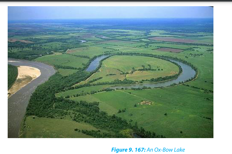
either a part of the sea into a lagoon, or part of a distributary into a lake. TheEtang de Vaccares is a delta lake. Delta lakes occur in the Nile Delta, in Egypt.
e. Flood plain Lake: A levée sometimes prevent water from returning to the
river, thus causing a lake to form. There are several lakes of this type on theRiver Congo.
f. Boulder clay Lake: Some boulder clay deposits contain depressions which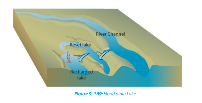
become the sites for lakes. There are lakes of this type in Northern Ireland.
g. Lakes produced by marine deposition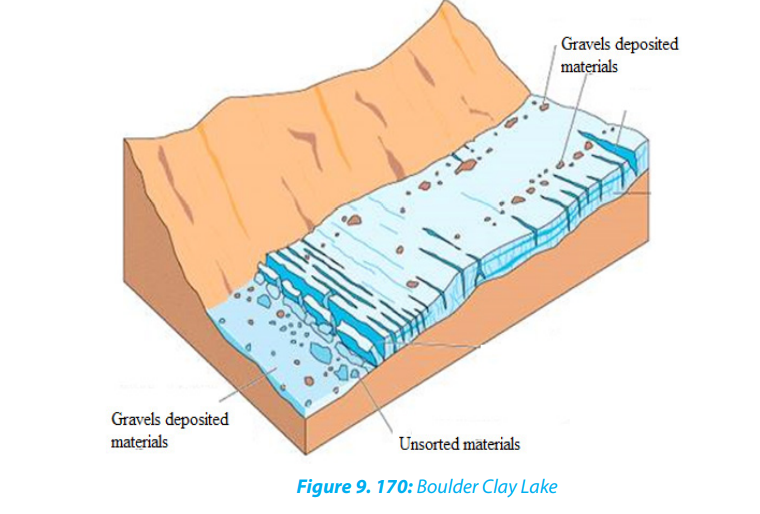
Lagoon: This is a lake formed by a sand bar or sand spit extending along a coast
and cutting off a coastal indentation hence forming a lagoon. Sometimes a barrier
beach extends across the mouth of a river, producing a lagoon.
9.6.3. Impact of lakes
The usefulness of lakes to human society are briefly described below.
• Source of fish: Lakes are habitats for different varieties of fish. This has favoured
the development of fishing and related industries.
• Source of minerals and natural gases: lakes such as Magadi in Kenya, Natron
in Tanzania and Katwe in Uganda are source of salt, Lake Kivu in Rwanda
contains natural gas.
• Tourism: Lakes provide beautiful sceneries and other activities which attract
tourists. This earns a country foreign exchange.
• Cheap transport: Lakes form cheap natural waterways for goods and
passengers.
• Source of power: Some lakes have been harnessed for the generation of
hydroelectric power. For example, Lakes Burera and Ruhondo generate power
on Ntaruka hydroelectric power plant.
• Source of useful water: Lakes are sources of water for domestic and industrial
uses.
• Source of drinking water for animals like cattle, sheep, goats, etc.
• Source of building materials: Some lakes are source of building and
construction materials such as sand, pebbles, small rocks, water used in
construction, etc.
• Regulating river flow: Some lakes help in controlling floods by regulating the
flow of rivers.
• Modification of climate: Lakes are important factors controlling the climate
of the surrounding areas because they provide the moisture. The lakes also
modify the climate of the adjacent areas.
• Source of rivers: Some lakes are sources of rivers. They act as reservoirs and
stores of water to rivers. For example, Lake Kivu is a source of river Rusizi, Lake
Muhazi is source of Nyabugogo River, etc.
9.6.4 Distribution of seas and Oceans
a. Distribution of Seas
A sea is a very large mass of saline water that occupies a very huge depression. Seas
occupy large basins on the continental margins. Lakes are smaller than seas but seas
are also smaller than oceans. Seas are of two types namely:• Inland seas. These are shallow seas over part of a continent. They are connected
to oceans by straits
• Marginal Sea. This is a sea partially enclosed by islands, archipelagos, or
peninsulas, adjacent to or widely open to the open ocean at the surface, and/or bounded by submarine ridges on the sea floor.

b. The distribution of oceans
An ocean is a large mass of saline water. Oceans occupy basins between continents.
There are five oceans in the world. These are as follows:
• Southern (Antarctic) Ocean: with an area of 20 million kilometers square
• Arctic Ocean: with an area of 14 million kilometers square
• Indian Ocean: with an area of 68.5 million kilometers square
• Atlantic Ocean: with an area of 76 million kilometers square
• Pacific Ocean: with an area of 155 million kilometers square
9.6.5. Importance of seas and oceans
Oceans and seas are very important either to human beings or to climate and the
adjacent areas. The following are the importance of oceans and seas:
• Source of fish: Oceans and seas form habitats for fish. This has promoted the
development of fishing and related industries.
• Tourism: Lakes provide beautiful sceneries which attract tourists. This earns a
country foreign exchange.
• Cheap transport: Ocean and seas are used by ships in transporting goods and
passengers.
• Source of useful water: Oceans and seas provide water for domestic, industrial
uses.
• Source of drinking water for animals like cattle, sheep, goats, etc.
• Regulating river flow: Some seas help in controlling floods by regulating the
flow of rivers.
• Modification of climate: Oceans and seas are important factors controlling
the climate in a given area because they provide the moisture. The oceans and
seas also moderate the climate of a given area.• Ends/sources of rivers: Some seas and oceans form sources/ends of rivers
Application activity 9.6
1. Draw a sketch map of Rwanda and on it indicate the types of Lakes.2. Explain their mode of formation.
9.7 Marine Relief
Learning activity 9.7.
Use internet and geographical resources and answer the following questions:
i. Explain the types of Marine relief.ii. Identify the location of Great Barrier Reef in Australia
9.7.1 Marine Relief
Ocean basins are characterized by five relief zones: continental shelves, continental
slopes, deep-sea plains, oceanic trenches and oceanic ridges.
i. Continental shelf (platform): This is a continental marginal area submerged
under oceanic water with average water depth and gently sloping towards
the sea or ocean. The width of continental shelves largely depends on the
nature of relief of the coastal land.
ii. Continental slope: This is a zone of steep slope extending from the
continental shelf to the deep-sea plains.
iii. Deep sea plains (Abyssal Plains): A deep sea plain is a flat and rolling
submarine plain in the ocean/sea basin. These deep-seated plains are found
in the depth from 3000m to 6000m.
iv. Oceanic trenches (deeps): Oceanic trenches are depressions of the sea
floor, relatively narrow in width, but very long. They are the deepest parts of
the ocean floor. Very deep but less extensive depressions are called deeps
while long and narrow linear depressions with steep side slopes are called
trenches. For example, the Mariana trench in western Pacific Ocean is thedeepest in the world.
v. Ocean ridges: The submarine ridges with steep side-slopes sometimes
reach the sea level and even project above the water surface and appear asislands. For example, the Mid-Atlantic ridge in the Atlantic ocean.
9.7.2 A case study of the Great Barrier Reef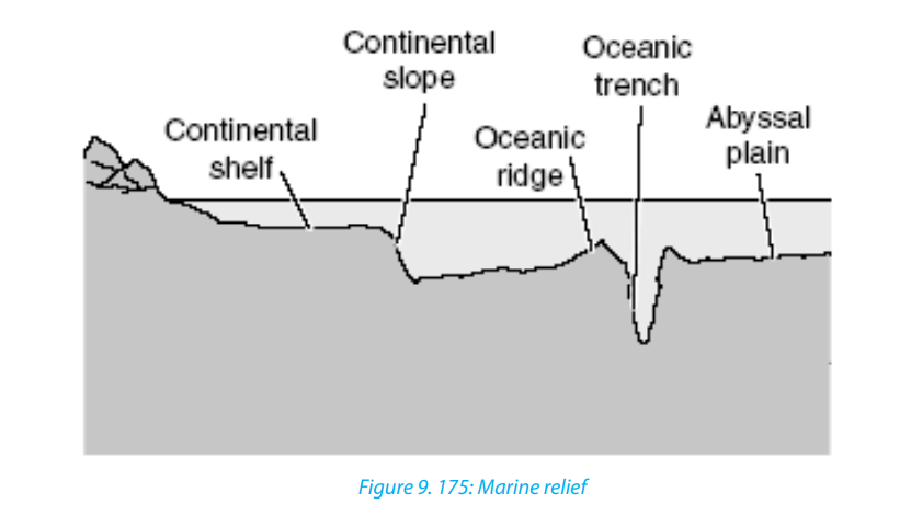
The Great Barrier Reef is the world’s largest coral reef system composed of over 2,900
individual reefs and 900 islands stretching for over 2,300 kilometres (1,400 mi) over
an area of approximately 344,400 square kilometres. The reef is located in the Coral
Sea, off the coast of Queensland in Australia.
The Great Barrier Reef can be seen from outer space and is the world’s biggest single
structure made by living organisms. This reef structure is composed of and built by
billions of tiny organisms, known as coral polyps. It supports a wide diversity of life
and was selected as a world Heritage site in 1981. The Queensland National Trust
named it a state icon of Queensland.
A large part of the reef is protected by the Great Barrier Reef Marine Park, which
helps to limit the impact of human use, such as fishing and tourism. Other
environmental pressures on the reef and its ecosystem include run off, climate
change accompanied by mass coral bleaching, and cyclic population outbreaks ofthe crown-of-thorns starfish.
The Great Barrier Reef has long been known to and used by the Aboriginal Australian
and Torres Strait Islander peoples and is an important part of local groups’ cultures
and spirituality. The reef is a very popular destination for tourists, especially in theWhitsunday Islands and Cairns regions.
Application activity 9.7
1. Describe the contribution of marine relief to the aquatic life.
2. Discuss the economic importance of the Great Barrier Reef to the peopleliving in Australia.
9.8. Ocean currents
Learning activity 9.8
Observe the map provided below and identify the major types of Oceancurrents in their respective locations.
9.8.1 Definition, types and location of major ocean currents
Definition
Ocean currents are slow and steady movements of a mass of oceanic water in a
definite direction. It is more or less similar to water streams (rivers) flowing on the
earth’s surface. Ocean currents are the most powerful of all dynamics of oceanic
waters because they pass over thousands of kilometers. Ocean currents are
categorized according to their areas of origin and temperature. They are warm
ocean currents and cold ocean currents. They are divided, on the basis of velocity,
dimension and direction into drifts, currents and streams.
Types and location of major ocean currents
Ocean currents are classified into surface or horizontal currents and vertical ocean
currents. Surface currents move water horizontally parallel to the earth’s surface.
Surface currents are powered by wind. Friction between wind and water causes the
water to move, driving ocean water in huge circular patterns all around the world.
Surface ocean currents include warm currents also called equatorial currents.
Trade winds drive the ocean surface waters westward in a concentrated channel
along the equator. As these surface currents approach the western margins of the
oceans, the water actually piles up against the eastern shores of the continents. This
phenomenon is the western intensification.
The piled-up ocean water then goes where it can, spilling northward and southward
in strong currents, flowing in tight channels along the eastern shorelines. As these
currents move towards the west, they are deflected by continents and move either
direction northward and southward along the eastern coasts of continents. For
instance, in the Northern Hemisphere, the Gulf Stream and the Kuroshio (a current
east of Japan) move forcefully northward as a result of western intensification.
Cold ocean currents, also called cool ocean currents, move toward the East. Being
colder with higher density, they flow to replace warmer and lesser dense equatorial
surface currents moved westward which are actually being deflected left and
right by continents at their eastern coasts. These currents are deflected by westernmargins of continents and converge at the equatorial zone.
Ocean currents are located both on the western and the eastern coasts of continents.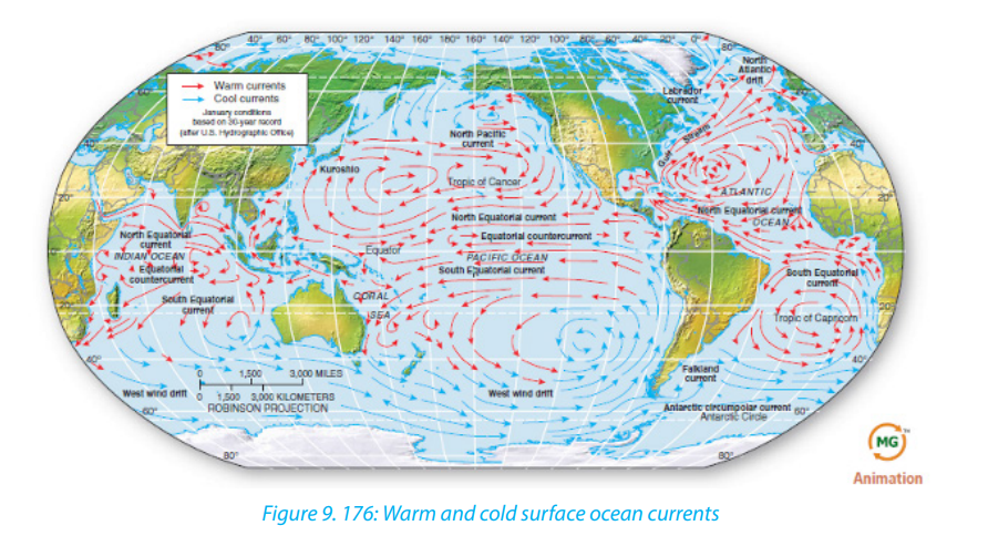
Several ocean currents have different names according to their areas of origin or
temperature. Major ocean currents of the world and their names are presented onthe map provided below.
Cold ocean currents
1. Californian Current
2. Humboldt current
3. Labrador current
4. Canaries current
5. Banguela current
6. Falkland current
7. West Australian current
8. Okhotsk current
Warm ocean currents
1. North pacific drift
2. North Equatorial current
3. Equatorial counter current
4. South Equatorial current
5. West wind drift
6. Gulf stream
7. North Atlantic drift
8. North Equatorial current
9. Equatorial counter current
10. South Equatorial current
11. Brazil current
12. West wind drift
13. Monsoon current
14. Equatorial counter current
15. South equatorial current
16. Mozambique current
17. West wind drift
18. Japan current
19. North equatorial current
20. Equatorial counter current
21. South Equatorial current
22. East Australian Current
Vertical ocean currents include upwelling and downwelling flows
Where surface water is swept away from a coast, either by surface divergence
(induced by the Coriolis force) or by offshore winds, an upwelling current occurs.
Upwelling is a circulation in the ocean that brings deep, cold water to the ocean
surface. In upwelling, wind blowing offshore carries water away from the land. When
surface water is pushed away, cold water from deep in the ocean rises to replace thevacating water. This cool water, generally, is nutrient-rich. Regions where this occurs
are known as good fishing areas. Such cold upwelling currents exist off the Pacific
coasts of North and South America and the subtropical and mid-latitude west coast
of Africa. These areas are some of Earth’s prime fishing regions.
In other regions with an accumulation of water - such as at the western end of an
equatorial current, or in the Labrador Sea, or along the margins of Antarctica - the
excess water gravitates downward in a downwelling current. These are the deep
currents that flow vertically and along the ocean floor and travel the full extent of
the ocean basins, carrying heat energy and salinity.
9.8.2 Causes and characteristics of ocean currents
a. Causes of ocean currents
Surface ocean currents, like surface winds, are influenced by the Coriolis Effect. The
Coriolis effects deflects currents north of the equator, such as the Gulf Stream, to
the right. Currents south of the equator are deflected to the left. The continents
also influence ocean currents. Currents moving towards the west in the Pacific
are deflected by Asia and Australia. The current deflected by Coriolis Effect move
eastward until North and South America deflects them.
There are several factors or causes of ocean currents. These are:
• The factors relating to the earth’s nature and its rotation such as gravitational
force and deflective force by earth’s rotation.
• Oceanic factors like pressure, gradient, temperature variations and salinity
differences.
• Ex-oceanic factors like atmospheric pressure and winds, evaporation and
precipitation.
• Current modifying factors like direction and shape of coastlines, relief of the
ocean basins, seasonal variations and rotation of the earth.
b. Characteristics of ocean currents
• Ocean currents are classified as either warm or cold depending on their origin
and temperature.
• Ocean currents which flow from the Equator towards the poles are warm,
while those flowing from the poles towards the Equator are cold.
• In the Northern Hemisphere, Ocean currents move clockwise, while in the
Southern Hemisphere, their movement is anticlockwise.
• Warm ocean currents occur mainly on the eastern margins of continents, while
cold ocean currents occur on the western margins of continents.
Geography Senior Six Student Book 273
9.8.3 Influence of ocean currents on the climate and e adjacent lands
the Ocean currents have both positive and negative influences on climate and theadjacent lands. These influences are:
• Modification in the coastal climate and inlands: Ocean currents while
flowing along the coasts modify their weather conditions in a number of ways.
The most effective impacts of ocean currents are seen on the temperature of
affected coastal lands. The effects are both positive (beneficial) and negative
(injurious) to flora and fauna.
• Ocean currents help in maintaining the temperature balance of ocean
water as the warm currents transport warm waters of the tropical zones to the
colder areas of the temperate and polar zones and cold currents bring cold
waters of high latitudes to the areas of low latitudes.
• Cold ocean currents, on the other hand, lower down the temperature
considerably of the affected areas and thus cause snowfall. The winds blowing
over warm currents pick up moisture and help in increasing the amount of
precipitation in the affected coastal areas.
• Effects on fishing: Ocean currents act as distributing agents of nutrients,
oxygen and other elements necessary for the existence and survival of fishes.
Ocean currents transport planktons from one area to another area. These
planktons are useful food for fishes.
• Effects on trade and navigation: Ocean currents were used to determine
major ocean routes for the navigation of commercial ships in ancient times.
Today’s power-motored ships do not rely the ocean currents and prevailing
winds for guidance. The occurrence of fog due to convergence of warm and
cold currents poses serious threats to navigation. Larger icebergs brought bycold currents damage ships.
Application activity 9.8
1. Explain why some ocean currents are warm whereas others are cold.2. Describe the effects of ocean currents to the climate of East Africa
9.9. Ocean tides: Definition, types, causes and the effects
Learning activity 9.9
Do research using internet and geographical resources to describe thecauses and effects of tides
9.9.1 Definition and types of tides
A tide is a pattern of twice-daily oscillations in sea level, (rise) and (fall), produced
by astronomical relations among the Sun, the Moon, and the Earth; experienced in
varying degrees around the world.
The rise of seawater and its movement towards the coast is called flood and the
resultant high water level is known as high tide water. The fall of seawater and its
movement towards the sea is called ebb and the resultant low water level is called
low tidal water. The difference between high tide water and low tide water is called
tidal range. The sea waves generated by tides are called tidal waves. The highest tidal
waves are commonly referred to as, “Tsunami” off the coast of Japan.
The major types of tides are briefly described below:
i. Spring tides
They are generated by the increase in gravitational attraction, which produces the
highest high tides, the lowest low tides, and the maximum tidal range. They take
place when the sun, the moon and the earth are almost aligned. The height of such
spring tides is 20% more than the normal tides. Such tides occur twice every month(during full moon and new moon) and their timing is fixed.
ii. Neap tides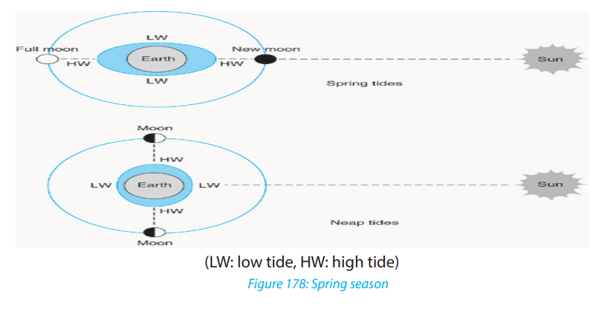
They are midway between the Spring tides. Neap tides occur when the sun, the earth
and the moon form a right angle with the earth at the apex. In this arrangement, the
Moon and Sun cause separate tidal bulges, affecting the water nearest to each of
them. In addition, the left-behind water resulting from the pull of the body on theopposite side augments each bulge.
iii. Tropical and equatorial tides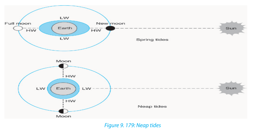
The position of the earth, the moon and the earth in straight line is called Syzygy.
When the sun, the moon and the earth are in sequential order in straight line, in
other words when the sun and the moon are in one side of the earth, the position
is called conjunction (the situation of solar eclipse). When the position of the earth
is in between the sun and the moon, this is called opposition. On the other hand,
when sun, the earth and the moon are in position of right angle, this position is
called quadrature. When there is maximum declination of the moon to the north of
Equator, the moon’s rays fall vertically on the tide centers and hence spring tides are
caused. Spring tides are also caused along the Tropic of Capricorn which is opposite
to the tropic of Cancer. These types of tides are also called tropical tides. When the
moon is at vertical position to the Equator (once per month) the tide caused is calledequatorial tide.
iv. Perigean Tides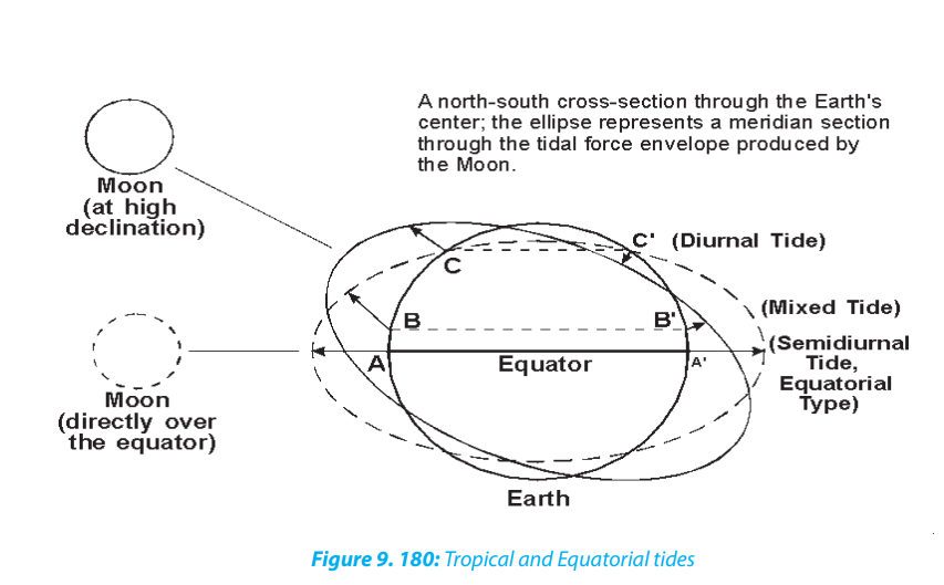
These are characterized by the high tides which are much higher than normal. They
occur when the moon is at its nearest point to the earth and thus its gravitational
effect is the greatest.
v. Apogean Tides
These are tides with a small tidal range. They occur when the moon is far away from
the earth. At this junction its gravitational effect is at the lowest point causing thehigh tide level to be lower than usual.
vi. Daily and semi-diurnal tides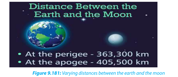
The tides recurring at the interval of 24 hours 52 minutes daily are called diurnal or
daily tides while the tides recurring at the interval of 12 hours 26 minutes are calledsemi-diurnal tides.
9.9.2. Causes and effects of tides
The origin of tides in the oceans is primarily concerned with the gravitational forces
of the earth and the moon. The earth rotates from west to east and revolves around
the sun following an elliptical orbit. Similarly, the moon rotates from west to east
and revolves around the earth along an elliptical orbit so that the distance between
the moon and the earth changes during different times in every month.
The gravitational force of the moon will be at its maximum at the earth’s surface facing
the moon, while it will be minimum at the opposite side of the earth. Consequently,
the water on the earth’s surface facing the moon is attracted and pulled and high
tides occur.
There are many effects of tides as explained below.• The daily rising and falling of the sea level generates tidal waves which can beApplication activity 9.9
harnessed to produce electricity. This is done at St. Malo in North West France.
• Tides generate strong and swift ebb and flood currents. The flow in and out of
bays through narrow inlets causes erosion.
• Tidal currents carry very fine silt and clay in suspension. These fine sediments
settle on the floor of bays and estuaries where they accumulate in layers and
gradually fill them up. This may silt up harbours hence hindering water transport.
• High tidal waves may flood coastal settlements leading to destruction ofproperty and loss of life.
1. Explain the relationship between tides and winds.2. Describe the effects of tides on lake shores of Rwanda
9.10. Reasons for protection of global water bodies
Learning activity 9.10:
Explain the importance of protecting water bodies?
Water is one of the most essential commodities apart from air but we tend to take it
for granted. That is why we don’t seem to have enough even though we have morethan we needed in our motherland.
The following are the major reasons for protection of global water bodies:
i. Economic uses: Water is needed by human beings for drinking, washing,
cooking, and for sanitation. The recommended basic requirement for
domestic purposes is about 50 litres a day. Thus, for a world population of
slightly more than 7 billion people, the total volume of freshwater needed
for domestic use annually is at least 110 x 109m3
ii. Agricultural use: The volume of water needed by agriculture to grow
the food to keep the population alive also must be added to this total.
Agricultural water needs are much greater than human consumption
needs, given that 600 and 1,800m3
is needed each year to grow the food
for one individual. Industry also uses large volumes of water. Including
hydropower, navigation and fishing, over 6,000 km3
of water are presently
used each year (estimates vary) for activities with economic considerations,
of which about 67% is used for irrigated agriculture and less than 3% for
domestic purposes.
iii. Recreational uses: Many freshwater bodies are used for sports activities,
boating, sightseeing, swimming, photography and other active or passive
recreational pursuits. They are also important for sports and commercial
fishing. Unfortunately, due to lack of knowledge about their impacts,
introducing fish from other places into a new environment lacking their
natural controls (e.g., predators, environmental conditions), has resulted
in some cases in the decimation of existing native fish species, while also
affecting entire local.
iv. Aesthetic values: Often termed ‘inspirational’ or ‘spiritual’ values, these
values are impossible to place a price on - indeed, there are some who say
these values are priceless! However, although difficult to quantify, such
values have long attracted the attention of poets, artists, writers and the
religious.
v. Cultural values: Many lakes and rivers have played a critical role in human
history, forming an integral part of our common cultural heritage. Religion
and socio-cultural values are part of the human existence. Also a beautiful
place for praying (Photo 5), they can facilitate lasting participation in
achieving the goal of integrated watershed management for sustainable
water use.
vi. Educational uses: As discrete, biologically-comprehensive and accessible
habitats, lakes, rivers and other bodies of inland water also represent unique
educational ‘tools’ for informing and educating the public.
vii. Scientific values: The biota and ecological processes of freshwater bodies
have long attracted attention from a number of scientific disciplines,
being the subject of countless investigations. Such investigations are very
important, primarily because they tell us how parts of the living world are
structured and how they function, as well as what the past was like, and
perhaps what the future may be.
viii. Ecological values: As integral parts of the global hydrologic cycle, pathways
for the circulation of essential elements, and repositories for a significant
fraction of the world’s biodiversity, freshwaters have an important ecological
role in sustaining the planet’s life-support systems. These so-called
‘ecosystem services’, like many other non-recognized-economic values, are
difficult to value economically, although studies are underway to develop
tools for assessing these services. One estimate is that the annual value of
ecosystem services provided by wetlands, lakes and rivers in the world areworth about US$ 6.6 trillion dollars.
Application activity 9.10
1. Discuss the ways you use to protect water at your school.
2. Visit a river or lake shore in your local environment and identify what thepeople around have done to protect it.
End unit assessment
1. Some ocean currents originate from warm regions and others from
cold regions. Describe the relationship between ocean currents and the
atmospheric circulation.
2. Conduct your own research to describe the major ocean management
projects in the world.
3. Discuss the economic advantages of drainage in Rwanda, and in the
world.
4. Explain the strategies to mitigate natural hazards associated with drainagesystem