Geography and Environment
- S1: Geography TG File Uploaded 16/08/22, 09:52
- S1: Geography SB File Uploaded 16/08/22, 09:56
UNIT 10:General organisation of hydrography

By the end of this unit, you must be able to analyse the general organisation of hydrography and its relationship with human activities.
Unit objectives
By the end of this unit, you must be able to:
(a) state different types of water bodies
(b) identify the major terminologies related to drainage
(c) identify major rivers of the world
(d) explain different parts of river profile and their characteristics
(e) identify different drainage patterns
(f) explain the relationship between drainage and human activities.Hydrography is the study of water bodies of the Earth. The water bodies include oceans,
seas, rivers and lakes.
Mukamwezi’s class teacher took the class to the Kiniha slum area in Karongi district.
The class went for a field study. Mukamwezi observed that the surroundings in the areawas very dirty. She saw dirty water flowing almost everywhere carrying all types of waste. It also had a bad smell that polluted the area.
(a) Describe the environment in the slum area.
(b) What description is given to the condition where dirty water flows everywhere without proper direction?Definition of drainage
Drainage refers to the natural or artificial removal of surface and sub-surface water from an area. This is done through a system of natural streams in the ground or through pipes.Water bodies

Do this in pairs.
Use the Internet, maps of Rwanda, photographs and geography textbooks.
1. Name the categories of the water bodies found in Rwanda.
2. Describe their characteristics that justify them to be under the categories that you have put them.3. State the importance of the water bodies to Rwanda.
4. Discuss your findings in class.A water body is any significant accumulation of water on the earth’s surface. The water
bodies are categorised into two.• Natural water bodies
• Artificial water bodiesExamples of natural water bodies include oceans, seas, lakes, swamps, rivers and ponds. Reservoirs, dams, canals and artificial lakes are examples of artificial water bodies.

In groups, use geographical resources such as textbooks, the Internet and documentaries.
1. Find out the main types of water bodies.
2. Describe their characteristics.
3. Identify the water bodies in your country.
4. Write down your findings and present in class.The main water bodies include the following.
(a) Oceans - An ocean is a large and extended body of salty water occupying a basin between continents. Examples of oceans of the world include the Indian Ocean, Atlantic Ocean, Pacific Ocean, Arctic Ocean and Southern Ocean.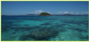
Fig 10.1 The Indian Ocean.
(b) Lakes - A lake is a body of water contained in an extensive depression on the earth’s
surface. The water in the lake may be salty or fresh. Examples of lakes in Rwanda include Lake Kivu, Lake Ruhondo, Lake Mugesera, Lake Burera, Lake Muhazi and Lake Ihema.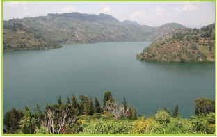
Fig 10.2 Lake Kivu in Rwanda.
(c) Ponds - A pond is a body of stagnant water that could either be natural or artificial. It is smaller than a lake and is surrounded by land.

Fig 10.3 A pond.
(d) Reservoirs - A reservoir is an artificial lake where water is stored. It is from reservoirs that dams are constructed across rivers. Examples of reservoirs in Rwanda include the Nyabarango and Rusumo dams.
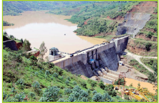
Fig 10.4 Dam on Nyabarongo River.
(e) Swamp - This is a flat uncultivated land where water collects. The ground is usually wet and soft and saturated with water. Rugezi, Kamiranzovu, Mwogo, Nyabugogo, Rwasave, Ngenda,
Sake, Mugesera, Ntende, Rwagitima, Muganza, Bugarama, Koko, Mugenoro are some of the swamps in Rwanda.
Fig 10.5 Rugezi marshland.
(f) Seas - A sea is a large body of salty water found on the margin of oceans.
It is partially enclosed by land. It is smaller than an ocean. Examples of seas include Mediterranean Sea, Baltic Sea, Red Sea and Dead Sea.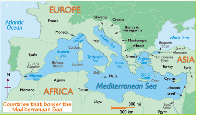
Fig 10.6 A map showing the location of the Mediterranean Sea.
(g) Rivers - A river is a stream of water which flows in a channel from a high ground to a low ground. It flows into an ocean,
sea, lake or swamp. Rivers in Rwanda include Mwogo, Rukarara, Mukungwa, Base, Nyabarongo and the Akanyaru and the Akagera Rivers.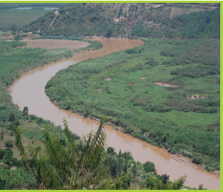
Fig 10.7 River Nyabarongo in Rwanda.
There are different types of rivers. They include:
(a) Perennial river - This is a river that contains water throughout the year. It can also be referred to as a permanent river. An example is River Nyabarongo.
(b) Intermittent river – This is a river whose surface water ceases to flow at some point in time. Such rivers periodically stop flowing. Such rivers drain large arid and semi-arid areas. An
example is River Kidepo in Uganda.
(c) Ephemeral river – This is a river that flows periodically and only exists for a short period. It flows immediately following heavy rains or snow melt.Task 10.1
1. Draw correct diagrams showing the following.
(a) A reservoir
(b) A river
(c) A pond.
2. Identify the main water bodies in Rwanda.
3. Differentiate between a perennial and an intermittent river.Major rivers of the world

1. In pairs, use an atlas to identify and locate the main rivers of the world.
2. Identify their sources and mouths.
3. Share your findings in a class presentation.Some of the major rivers of the world include the following.
Table 10.1 Major rivers of the world.

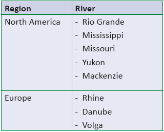

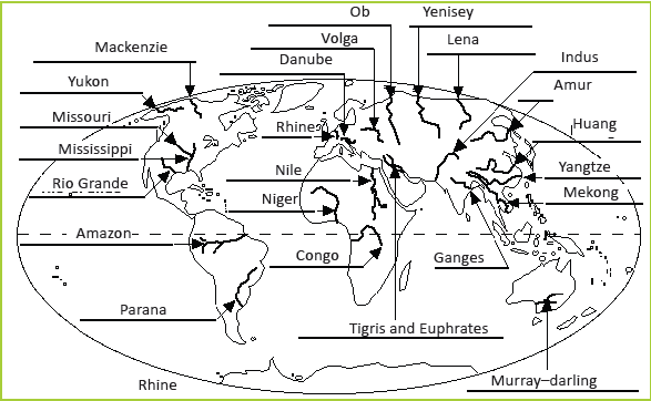
Fig 10.9 Rivers of the world.

Do this individually.
1. Draw a sketch map of the world. On it, mark and name the main rivers of the world.
2. For each of the main rivers in (a) above, name their sources.
3. Name the continents and countries that contain each of the rivers you have named.
4. Present your work for marking.
1. Use an atlas or the Internet to identify the major rivers of the world marked by the arrows shown.
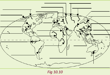
2. Present your findings in a class discussion.
River profile

Work in groups of three. Study the photographs shown below.
1. Identify the parts of the river profiles that are shown in the pictures.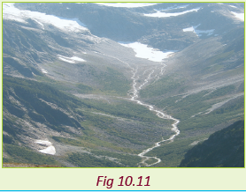

2. Discuss the characteristics of each of the stages identified.
3. Present your findings in class.A river profile is the shape of the river course. There are two river profiles.
• The cross river profile.
• The long river profile.Parts of a river profile
Cross river profile
This is the transverse profile of a river from one bank to another. The river cross profile
changes from the upper to the lower course.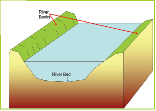
Fig 10.14 A cross profile of a river.
Long profile
This is the shape of a river along its course from the source to the mouth. The long profile is expressed graphically as a curve.
It has a steep gradient near the source but gradually flattens towards the river mouth.
The profile of a river is ideally expected to be smooth. However, this never occurs since the energy of the river changes as it flows through its course.The energy changes in the long profile may be caused by the following.
(a) Increase in the river discharge due to increased precipitation.
(b) Changes in the sea level. This may be either a rise or fall in the level of the sea.
(c) The land may rise or fall due to continental movements.The long profile of the river is divided into three stages.
• The youthful stage
• The middle stage
• Old stage
Fig 10.15 The long profile of a river
(a) The youthful stage (upper course)
This is the stage that is near to the river’s source. The river has a lot of energy due to the steep gradient. Erosion is the dominant function of the river.The characteristics of the youthful stage of a river:
(a) The river has a steep gradient.
(b) The water flows at a very high speed.
(c) There is a deep steep sided river valley.
(d) It has a narrow channel.
(e) Vertical erosion is dominant
(f) The river channel is V-shaped.(b) The middle stage
This stage is also known as the mature stage or the valley stage. It is the stage between the youthful and the old stages.
The gradient of the river channel is reduced.The river has more stream volume since more tributaries join it.Characteristics of the middle stage of a river:
(a) The river has wide U-shaped valley.
(b) The gradient of the river channel is gentle.(c) The water speed is moderate.
(d) There is high stream volume.
(e) The river erodes its valley laterally thus widening it.
(f) Both erosion and deposition take place at this stage.(c) The old stage (lower course)
This is the stage that is close to the river mouth. The gradient of the river channel is very gentle. The main function of the river is deposition though lateral erosion still occurs.Characteristics of the old stage of a river:
(a) The gradient of the river channel is very low.
(b) The speed of the river is very low.
(c) The stream volume is large.
(d) The river valley is wide and U-shaped.
(e) Deposition occurs on the river channel making it shallow.Task 10.2
1. What is a long profile of a river?
2. Name three stages of the long profile of a river.
3. Name the features found in each stage of the long profile.
4. State the characteristics of the river in each stage.Drainage patterns
A drainage pattern is the arrangement of a river and its tributaries on the earth’s surface. Drainage patterns tell a lot about the land. Drainage patterns are influenced by:
• the slope of the land• differences in the rock resistance
• rock structure.
There are different types of drainage patterns. They include:
• radial
• dendritic
• trellis
• centripetal
• parallel(a) Radial drainage pattern
This is a drainage pattern that forms on volcanic cones or domes.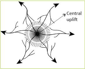
Fig 10.16 Radial drainage pattern.
The rivers flow outwards from a central high point. The pattern resembles the spokes of a bicycle wheel. The slope influences the direction of flow of the rivers.
(b) Dendritic drainage pattern
This drainage pattern looks like a tree trunk and its branches. The tributaries flow towards the main river from many directions. They join the main river at acute angles. This pattern develops in an area with gentle slopes with fairly uniform rock type.
The direction of flow is influenced by the slope. It is common on massive crystalline rocks such as granite. It also develops on horizontal gently dipping sedimentary rocks.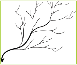
Fig 10. 17 Dendritic drainage pattern.
(c) Trellis drainage pattern
This is a pattern where the tributaries join the main river at right angles. The minor tributaries also join the main tributaries at right angles. It develops in areas where there are alternate layers of hard and soft rocks. These rocks lie at right angles to the main direction of slope. The main river is
powerful enough to cut through the hard rocks while the tributaries cut through the soft layers of rocks at right angles. The minor tributaries cut valleys into the less resistant rocks. The hard layers of rocks protrude as ridges.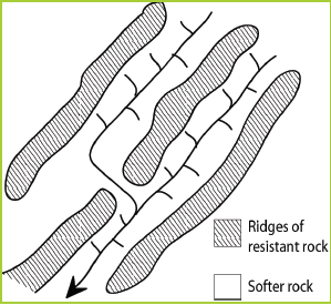
Fig 10.18 Trellis drainage patterns.
(d) Centripetal drainage pattern
This is a drainage pattern where rivers flow from all directions into a common basin.
The common basin could be a swamp or a lake. The direction of flow of the rivers is influenced by the slope.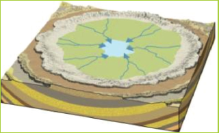
Fig 10.19 Centripetal drainage pattern.
(e) Parallel drainage pattern
This is a drainage pattern where the main river and its tributaries flow parallel to each other. It occurs over a large area. The slope determines the direction of flow of the river. It is common on steep slopes and escarpments. Tributaries join the main river at small acute angles.
Fig 10.20 Parallel drainage pattern
(f) Fault guided drainage pattern
This is a drainage pattern where rivers flow along fault lines. This occurs in areas that have experienced faulting. The direction of flow is influenced by the faults. The tributaries form very sharp bends along their course. This drainage pattern is also referred to as rectangular drainage pattern.
Fig 10.21 Fault guided or rectangular drainage pattern.
(g) Annular drainage pattern
This is a drainage pattern around a basin or crater. It forms when the main river and its tributaries are arranged in a series of curves around a basin. The tributaries join the main river at sharp angles. Lake Bosumtwi in Ghana forms this pattern.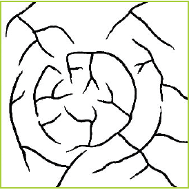
Fig 10.22 Annular drainage patterns.

Work in groups of three. Use an atlas.
1. Identify the different drainage patterns of the major rivers of the world.
2. List the patterns and match them to specific rivers.
3. Discuss your findings in class.
Work in groups of four.
1. Collect clay soil and water.
2. Mix the two well
3. Mould the following drainage system.
(a) Radial drainage pattern
(b) Dendritic drainage system
(c) Trellis drainage pattern
(d) Centripetal drainage pattern
(e) Present your work for assessment.Task 10.3
1. What is a drainage pattern?
2. State three factors that influence the formation of drainage patterns.
3. Describe the characteristics of the following drainage patterns.
(a) Dendritic
(b) Radial
(c) Centripetal
(d) TrellisRelationship between water bodies and human activities
The relationship between the water bodies and human activities can be looked at in two ways.
(a) The influence of water bodies on human activities.
(b) The influence of human activities on water bodies.Influence of water bodies on human activities

Do this in pairs.
1. Outline the ways in which human activities are influenced by water bodies. Give examples from Rwanda.
2. Discuss your findings in class.Water bodies have a great effect on human activities. These effects include the following:
(a) Settlements
Water bodies that contain fresh water attract human settlements. This is because they provide water for domestic use.
(b) Agriculture
Fresh water bodies encourage agriculture by providing water which is used for irrigation. Rivers deposit alluvium in the flood plains. Alluvium contains fertile soils which are used for growing crops. The water bodies also provide water for livestock to drink encouraging livestock keeping.
(c) Transport
Lakes, seas, oceans and navigable rivers provide a cheap means of transport for people and goods.
(d) Fishing
Water bodies such as oceans, lakes, rivers are good habitats for fish and other aquatic life. Fishing is carried out in such water bodies for subsistence and for sale.(e) Mining
Some water bodies contain minerals in their beds. These minerals are mined.
Mining takes place as an economic activity. Minerals which are mined in water bodies include salt, trona and gold.
(f) Tourism
Water bodies form beautiful sceneries e.g. waterfalls and sandy beaches which attract tourists. Tourism earns foreign exchange which is used for economic development.
(g) Recreation
Some water bodies offer recreational activities. Water sports such as surfing, yatching and sport fishing are some recreational activities that people engage in.Industries
Water bodies such as rivers and lakes provide water which is used for industrial
purposes. Water bodies also provide raw materials which encourage the establishment of
industries. Fish leads to establishment of fish related industries.
(i) Ports
Some rivers have suitable sites for the construction of ports and harbours. Rias and estuaries at river mouths are used for construction of ports. Fiords form natural harbours.
(j) Hydroelectric power generation
Some rivers have been dammed and their water is used to generate hydroelectric power. The power is used for domestic and industrial purposes.(k) Building materials
Lakes and rivers contain sand, gravel and pebbles in their beds. These materials are extracted and used as building materials.
(l) Flooding
Water bodies such as rivers may flood causing the displacement of people, destruction of property. Floods also cause loss of lives.
(m) Water-borne diseases
Water bodies can be breeding grounds for disease-carrying organisms. Mosquitoes and snails transmit malaria and bilharzia respectively, which are water-borne diseases.The impact of human activities on water bodies

Work in pairs.
1. Outline the ways in which human activities affect water bodies. Give examples from Rwanda.
2. Discuss your findings in class.Human activities have an increasing impact on the water bodies. These activities include sedimentation, deforestation, pollution, landscape changes, urban growth and climate change.
(a) Sedimentation
Human activities such as farming, clearance of forests, mining and building of roads expose the soils to erosion. The soils are washed by surface runoff and are eventually deposited in the water bodies.The sediments affect water in various ways.
• They can harm aquatic life by carrying toxic chemicals into the water.
• They reduce the amount of sunlight penetrating the water.
• They add nutrients to the water encouraging the growth of plants (entrophication)
• Sediments reduce the capacity of reservoirs making them shallow.
This interferes with navigation and result in flooding of the areas adjacent to the water bodies.(b) Deforestation
The clearance of vegetation in the catchment areas exposes the soil to erosion leading to sedimentation in the water bodies.
(c) Pollution
Industrial wastes, sewage and surface runoff from the farm lands are disposed of into the
water bodies. They cause pollution making the water unfit for use. Gases emitted from factories and vehicles are released into the atmosphere. This leads to the formation of acid rain which damages vegetation and pollute the water.
(d) Excessive use of water
The excessive use of water from the surface and underground sources leads drying up of water bodies. Such water bodies include lakes, rivers and aquifers. Some of the rivers experiencing excessive use of include Niger and Nile.(e) Climate change
Some human activities lead to climate change. Climate change can result into wetter or drier climates in some regions of the world. In drier climates, a decline in the volume of the water bodies is witnessed.
(f) Landscape changes
The drainage of swamps to create dry land for agriculture interferes with the water balance. The water cycle is also destroyed leading to the depletion of wetlands. It also affects the flow of water into the lakes, eventually affecting their sizes.
(g) Urban growth
The expansion of urban centres results in increased contamination of underground water and surface water bodies. This occurs by direct discharge and surface runoff. Contamination can occur directly through seepage of soluble contaminants from septic tanks, landfills and other industrial
wastes.
Work in groups of three.
1. Why is it important to protect water bodies?
2. Suggest ways in which the citizens of Rwanda can protect the water bodies in Rwanda.
3. Giving examples in Rwanda, discuss how forests and mountains are responsible for the creation of rivers.
4. Discuss your findings in a class discussion.Did you know?
• Rivers normally contain freshwater.
• Most of the world’s major cities are located near the banks of rivers.
• The largest river drainage basin area in the world is that of the Amazon river.
• Rivers begin at their source in higher grounds such as mountains or hills.
• A dendritic drainage pattern is the most common form of drainage pattern.
1. Define drainage.
2. Give four types of water bodies.
3. List three terminologies related to drainage.
4. Identify the major rivers of the world and the continents in which they are located.
5. Discuss the different parts of a river profile and their characteristics.
6. Identify and describe seven drainage patterns.
7. (a) Explain how water bodies influence human activities. Give examples to support your answer.
(b) Discuss how human activities affect water bodies.