Geography and Environment
- S1: Geography TG File Uploaded 16/08/22, 09:52
- S1: Geography SB File Uploaded 16/08/22, 09:56
UNIT5:Forms of relief

By the end of this unit, you must be able to determine the relationship between relief
and human activities.Unit objectives
By the end of this unit, you must be able to:
(a) identify different forms of relief features
(b) state the relationship between relief and human activities.Relief
Relief refers to the character of the land surface of the earth. It comprises a wide variety of landforms. These landforms are located between the lowest and the highest elevation points on the land surface. Relief is also known as terrain.
A relief map shows the topography of an area. Topography is the lay of the land, the relief of a region taken as a whole.
Do this in groups of three.
1. Go outside your classroom and observe the landscape of the area.
2. Describe the appearance of the landscape.3. Name the physical features that you have seen on the landscape.
4. Write them down in your notebook.
5. Present your findings in a class discussion.Slope, altitude and contours

Do this in groups of three. Your teacher will take you to an area around your school.
1. Keenly observe the relief of the area.
2. Describe the nature of the relief of the area.
3. Name the types of slopes accordingly.
4. Write down your findings.
5. Present your findings in a class presentation.Slope
Slope is the rise or fall of a relief feature. It is a measure of the degree of inclination of a feature in relation to the horizontal plane.
The angle of elevation determines the type of slope.
The following are four main types of slopes.
• Convex slope
• Concave slope• Steep slope
• Gentle slope
(a) Convex slope
This is a slope, or slope element, that gets progressively steeper downhill. It may be determined by structure. Convex slopes may result from weathering and transportation of debris.
Fig 5.1 A convex slope.
(b) Concave slope
This is a terrain feature that is rounded inward like the inside of a bowl. It goes from more steep to less steep. It declines in steepness with movement downslope. It is also known as a waning slope.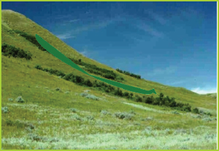
Fig 5.2 A concave slope.
(c) Steep slope
This is a relief feature that has an almost vertical slope or a relatively high gradient.
Fig 5.3 A steep slope.
(d) Gentle slope
This is a relief feature that is almost flat. Its elevation is flat when compared to the convex, concave and steep slopes.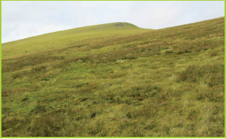
Fig 5.4 A gentle slope.
Altitude
This is the height or elevation of a point above a given reference point. In geography the reference level is the sea level. Sometimes, the ground level is used as the reference point. Altitude is expressed in feet or metres. Altitude is thus defined as the height above the sea level. Relief features are found at different altitudes.Contours
A contour is a line connecting points of the same altitude on a topographic map. Contours show the type of relief on the earth’s surface.
A landscape that is nearly flat is shown by contours that are far apart. On the other hand, contours that are close together indicate a steep slope.


Fig 5.6 A topographic map with physical features marked by contours.

Study the topographic map extract below.
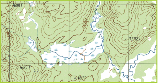
Fig 5.7
1. Describe the nature of the slopes in the landscape shown by the map.
2. Which side of the landscape has the highest altitude?
3. Write down your findings and present them in a class discussion.Forms of relief
Relief forms are classified into two main categories. These are continental and marine relief features.
Continental relief features
These are landforms that are found on the earth’s surface. The relief features of continents are varied. Some of the relief features are caused by the internal forces of the earth. These forces include tectonic plate movements, earthquakes and vulcanicity. Other features are caused
by external agents including wind, rain, temperatures, rivers, groundwater, ice and human activities.
The internal forces are responsible for the elevation of topography. The external agents cause erosion and modification of the earth’s relief.The main forms of continental relief include the following.
(a) Mountain A mountain is a large landform that rises above the area surrounding it. It usually
has a peak. Mountains are formed through tectonic forces or volcanism. Mountains may appear as a single landmass or in a chain called a range. Mountains erode slowly through the action of rivers, weather conditions and glaciers.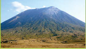
Fig 5.8 Mt Kilimanjaro.
An elevation is referred to as a mountain when it is 600 metres and beyond above sea level.
(b) Hill
A hill is a landform that extends above the surrounding terrain. It is however smaller than a mountain.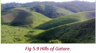
(c) Plain
A plain is an extensive tract of flat land or a gently undulating terrain. There are no prominent hills or depressions.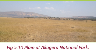
(d) Plateau
A plateau is an elevated tract of relatively flat land with a steep slope falling abruptly to a lower land on one or either sides. A plateau is higher than a plain.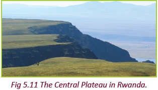
(e) Valley
A valley is a sunken land or depression surrounded by mountains or ridges. Rivers may flow along the valleys.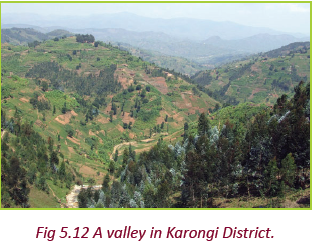
(f) Ridge
A ridge is a linear, steep-sided upland. It is a relief feature that consists of a chain of mountains or hills. These mountains or hills form a continuous elevated crest for some distance. Ridges are usually referred to as hills or mountains depending on their size.
Work in groups of three.
1. Go outside your classroom.
2. Observe the landscape in the surrounding area.
3. Name and list the landforms that you can see.
4. Identify the characteristics of the landforms you have identified.
5. Discuss the importance of the relief features you have identified to the area.
6. Discuss your findings in a class presentationMarine relief features
These are landforms that are found on the oceanic crust. The oceanic crust is bordered by a coast. A coast is a broad area of land that borders the sea. It has a variety of landforms. They include beaches, gulfs, cliffs and capes.
The main relief features of the ocean bed include the following.(a) Continental shelf
The continental shelf is an underwater landmass. It extends from a continent and results in an area of relatively shallow water.
This area is known as a shelf sea. Most of the shelves were exposed during glacial periods. The width of the continental shelf varies. It is wide in Japan, Canada and U.S.A but narrow in Africa.
The continental shelf allows sunlight to penetrate to the sea bed. This encourages the growth of planktons. Continental shelves are rich fishing grounds. This is due to the availability of planktons which are food for fish.
Fig 5.13 Continental shelf.
(b) Continental slope
This is a steep slope that extends from the edge of the continental shelf to the deep sea plain. A continental slope is typically about 20 kilometres wide. It consists of mud and silt, and is often cross cut by submarine canyons.
Fig 5.14 Continental slope.
(c) Oceanic ridge
This is a continuous submarine mountain chain extending approximately 80,000 kilometres through all the world’s oceans. It is formed from magma that rises from the mantle to occupy spaces formed as the sima rocks drift away from each other.
An example of an oceanic ridge is the Mid-Atlantic Ridge in the Atlantic ocean.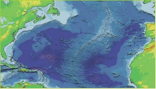
Fig 5.15 Satelite image of the Mid-Atlantic Ridge.
(d) Oceanic trench
This is a long narrow steep-sided depression in the Earth’s oceanic crust. It is the deepest part of the ocean floor. Examples of oceanic trenches are the Mariana and Atacama trenches. They are located to the West and East of the Pacific Ocean respectively. The Mariana Trench is about 10,994 metres deep. It is the deepest part of the world’s oceans. The Atacama Trench is about 8,065 metres deep.
Fig 5.18 An oceanic island in the South Pacific
Task 5.1
1. (a) Define continental relief features.
(b) Name two ways by which continental relief features are formed.
(c) Name three continental relief features found in Rwanda.
2. (a) What are oceanic relief features?
(b) Name three examples of oceanic relief features.Relationship between relief and human activities

Your teacher will take you on a field visit.
1. Observe the relief features present in the area.
2. Find out from a resource person or the people how the features influence their day to day activities. Ask for both the positive and negative influences.
3. Recommend activities that are friendly to the forms of relief found in the area.4. Note down the points in your notebook.
5. Discuss your findings in a class presentationsThe relief features in an area determine the human activities carried out in a place. The main activities that are influenced by relief features include transport, agriculture and settlement.
(a) Effects of relief on transport
(i) Type of relief in an area influences the establishment of transport and communication networks. Roads, railway lines and airports are mainly constructed on relatively level ground. This is because level ground is convenient and easy to break during construction of transport networks.(ii) Landscapes that are highly dissected have transport routes constructed along the valleys. This is because valleys are relatively gentle and easy to construct transport infrastructure on.
(iii) Roads constructed on steep slopes will ascend in a zigzag manner. This is done to reduce the gradient.
(iv) Wide river channels on relatively level land are suitable for navigation.
(v) Plains allow for the expansion of infrastructure. This is because they have even surfaces. Such a surface favours the building of roads and airports and laying of railway lines.
(b) Effects of relief on settlements
The type of relief in an area influences the distribution of settlements.(i) Gently sloping areas are suitable for agriculture. This is due to the deep soils hence attracting settlements. The landscape is also suitable for construction of houses.
(ii) Steep slopes have few settlements because it is difficult to construct houses on them. The soils on such slopes are thin and discourage farming.
(iii) Very flat areas that are covered with marshes and swamps have no settlements. This is because they are unsuitable for construction of houses.
They are prone to flooding and disease-causing insects such as mosquitoes.(iv) As much as 80% of the world’s population lives on plains.
(c) Effects of relief on agriculture

Do this in groups of three. Your teacher will provide you with a topographic map of Rwanda.
1. Identify the relief features on the map.
2. Find out the human activities that take place in the areas with the relief features.
3. Relate the features to the human activities that take place in the various areas.
4. Suggest human activities that you think are friendly to the forms of relief identified.5. Write your findings in your notebooks.
6. Discuss the findings in a class presentation.
7. Engage other group members in a question and answer session on their findings.(i) Gently sloping or undulating landscape encourage farming activities. This is due to the presence of deep, well-drained soils.
(ii) Very steep slopes discourage farming because of the thin soils.
(iii) Very high altitude discourages farming and settlement because of extremely low temperatures. The moisture in the soil is frozen and therefore unavailable for plant growth.
(iv) Highlands that experience lower temperatures and high rainfall have adequate pasture. Dairy farming is common in such areas.
(v) The suitable climate and fertile soils of the plateaus are helpful for animal - rearing and agriculture.
(vi)Perennial rivers arising mountains are important sources of water. They help in promoting the irrigation and provide water for many other uses.
(vii) The rivers from the high mountains carry silt along with water to the lower valleys. This helps in the formation of fertile plains for agriculture.
(viii) Plateaus have large grassland areas that are suitable for rearing sheep, goat and cattle. They provide a variety of products such as wool, milk, meat and hides and skin.
(ix) The lava plateaus are preferred for agriculture since their soils are very fertile.
(x) Plains generally have deep and fertile soils. Since the plains are flat it is easy to practise irrigation. These factors have made the plains agriculturally important. They are often called ‘food
baskets of the world’.(xi) The rich agricultural resources of alluvial plains have helped in the growth of agro- based industries. This has given employment to millions of people. It has also registered a marked
increase in the national production and per capita income. Since the plains are heavily populated, plenty of labour is available for the intensive cultivation. The population also supplies the work force needed for industries.(d) Effect of relief on other human activities
(i) Mountainous areas are usually forested areas. The presence of forests in such areas encourages lumbering which is an important economic activity.
(ii) Plateaus are useful because of the presence and easier way of extracting minerals. They also favour generation of hydropower.
(iii) Large resources of minerals are usually found in mountains. This encourages mining activities.
(v) Hydroelectricity is generated from the waters of perennial rivers in the mountain regions.
(vi) The pleasant climate and the beautiful scenery of the mountains have led to their development as centres of tourist attraction. The tourist and hotel industries get an additional encouragement in such regions.
An example is found at the Virunga Mountains of Rwanda.(vii) Most of the minerals in the world are found in the plateaus. For example tin and wolfram are found in the central plateau of Rwanda.
(viii) Rivers falling down the edges of plateaus form waterfalls. These waterfalls provide ideal sites for generating hydroelectric power. They are also good tourist attraction sites.
(ix) The easy means of transport on plains favour the growth of agriculture and industries. This has results in the expansion of cities and towns.
The most developed trade-centres and ports of the world are found in the plains. They include Rome, Tokyo, Calcutta, Yangoon (Rangoon), Varanasi, Paris and other famous cities are situated in the plains.(x) The plains have been the centres of many modern and ancient civilisations.
The major river valley civilisations of the world have flourished in them.Hence, they are referred to as the cradles of civilisation.
Do this in groups of three.
1. Use an atlas to identify the relief features in various parts of the world.
2. Find out the dominant human activities in the areas with the relief features.3. Relate the features to the human activities.
4. Write down four findings in your notebooks.
5. Discuss them with other members of your class.Did you know?
• Some of the highest mountains are at the bottom of the sea.
• The largest range of mountains is in the Atlantic Ocean.
• The deepest parts of the sea are found close to the margins of continents.
• The abyssal plain is among the flattest portions of the earth’s crust.
• Plateaus also form in the ocean.
1. (a) Define relief.
(b) Identify forms of relief.
2. Name the relief features found in Rwanda.
3. Differentiate between slope, altitude and contours.
4. Discuss the importance of the relief features of Rwanda to the country.
5. Explain how the relief features of Rwanda influence human activities in the country.
6. Suggest four ways through which Rwandans can preserve the relief features in the country.