General
- Geography S5 SB File Uploaded 28/01/22, 13:38
- S5 : Geography TG File Uploaded 19/08/22, 10:37
UNIT 6: INTERNAL LANDFORM PROCESSES
Key unit competence:
By the end of this unit, I should be able to examine the internal processes responsible
for the evolution of different relief landforms.

6.1. Faulting and processes leading to the formation of different faulted features
Learning activity 6.1
Using textbooks, internet, and other sources of geographical information research
on:
1. The meaning of the faulting and fault
2. The processes responsible for the formation of different faulted
landforms
Forces causing faulting
Faulting is the fracturing of the crustal rocks due to the influence of endogenic forces or processes. Endogenic forces are responsible for various types of vertical irregularities that give birth to numerous relief features including mountains, plateaus, plains, lakes, faults and folds. The endogenic forces include faulting, folding, warping, vulcanicity and earthquake. The endogenic forces and related horizontal movements are caused by the existence of convectional currents within the mantle. These lead to lateral earth movements, that are either tensional or compressional in nature. Sometimes there are up and downward movements that cause the crustal rocks to fracture, fold, down warp or up warp. The endogenic forces result in the formation of features or landforms such as plateaus, block mountains, basins and rift valleys.
Meaning of faulting and fault
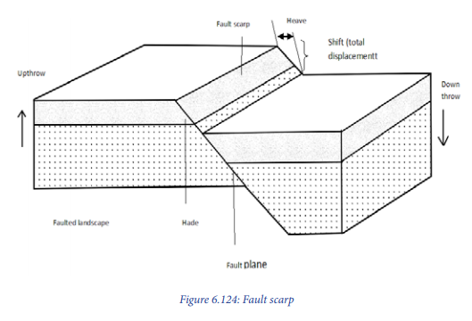
Faulting is the process through which the rocks of the earth’s crust crack or fracture due to tectonic forces as accompanied by the displacement of blocks. The direct effects of faulting include the formation of rift valley, block mountains, fault scarps, tilt block landscape, etc. A fault is a fracture in the crustal rocks where the rocks are displaced along a plane called a fault plane. A fault is also considered as a rupture or fracture of rock strata due to strain, in which displacement is observable.
Main parts of a fault
Processes of faulting: the process of faulting is caused by tensional and compressional forces. When these forces act on crustal rocks of the earth’s crust, they develop stress in them and break along the zone of maximum tension. The rocks are then removed from their original position either upwards, downwards or horizontally.
When a rock is displaced upward it is called up throw, and the downward displacement is called down throw.
Application activity 6.1
Rwanda is made up of six physiographic regions which resulted from different internal processes including faulting. With convincing examples/evidences support this statement.
6.2. Types of faults
Faulting leads to numerous types of faults that include the following:
i. Normal faults/consequent fault lines are formed due to the tensional forces that lead to opposite displacement of the rock blocks. The steep scarp resulting from normal faults is called fault-scarp or fault-line scarp.

ii. Reverse faults/ obsequent fault lines are formed due to compression forces that lead to the movement of the fracture rock blocks towards each other. The fault plane in a reverse fault is usually inclined.

iii. Lateral or strike-slip faults are formed when the rock blocks are displaced horizontally along the fault plane. They are called left-lateral or sinistral faults when the displacement of the rock blocks occurs to the left; on the other side of the fault, they are called right-lateral or dextral faults.

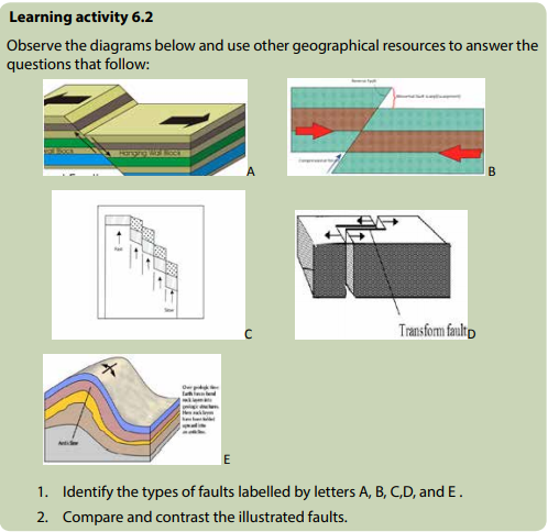
iv. Step faults are formed when many parallel faults occur within the crustal layers of the rocks in a way that the slope of the entire planes of the faults are in the same direction. The series of blocks are thereafter up lifted at different rate, therefore forming step faults.
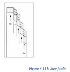
v. A thrust fault refers to a reverse fault in which the dip of the fault plane is at a small angle to the horizontal and it is caused by strong crustal compressional forces.
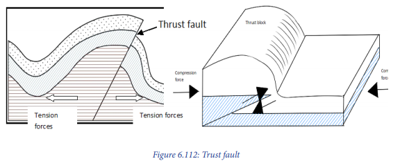
vi. Anticlinal faults are formed as a result of great compressional forces acting on layers of rocks. Compressional forces further cause stress leading to the development of cracks (faults) on the crest of the anticline.
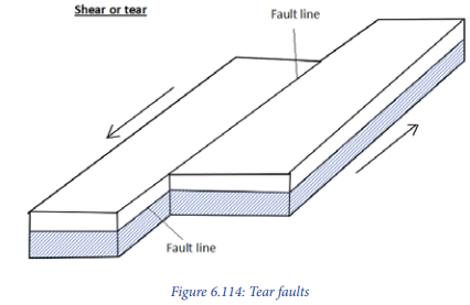
vii. Shear or tear faults/strike or wrench faults
These are formed as a result of horizontal movements caused by the intense stress coming from opposite directions but acting obliquely to one another. In case there is displacement of blocks during the formation of tear faults, that is, when there is both horizontal movement and vertical displacement, the fault formed will be called Oblique slip fault.
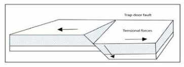
viii. Trap door fault is a type of fault produced by tension forces when fracturing does not cut through the whole crustal rocks (i.e: semi-diplacement takes place).
Application activity 6.2
Figure 6.115: Trap door fault Basing on the knowledge and skills acquired from the above lesson, describe the area where the faulting process occurred.
6.3. Influence of faulting on landscape and drainage
Learning activities 6.3
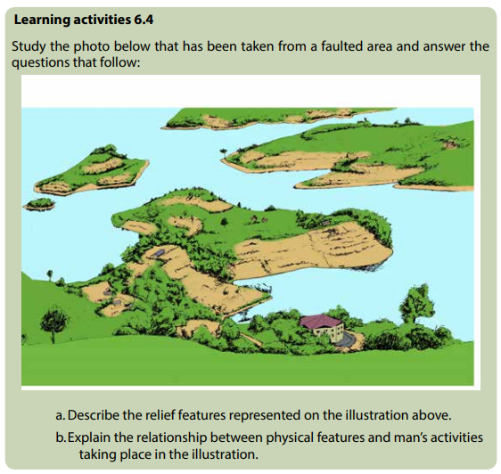
Kwigira and Mahoro are students from GS Terambere. They visited Lake Kivu and its surrounding area in the western part of Rwanda. Back to school, they were told to give the description of the area they had visited. In the description they included: Lake Kivu and other different relief features around. They said that their teacher called Bumwe who accompanied them explained how Lake Kivu was formed. He said that Lake Kivu was formed in the same way as Lake Tanganyika, Eduard, George, Manyara and Turkana in East Africa. Furthermore, teacher told them that there are other landforms which resulted from faulting in Africa and in the World. Basing on this story answer the following questions:
1. Describe the impact of faulting on the landscape of the area visited by
Kwigira and Mahoro.
2. Examine other landforms produced as a result of faulting not
mentioned in the passage above.
3. Assess the impact of faulting on the drainage system.
6.3.1. Influence of faulting on landscape
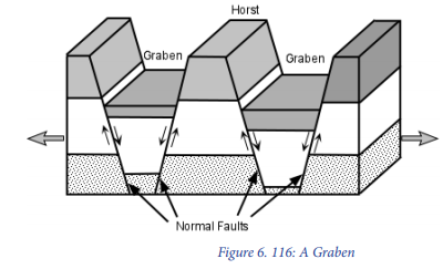
There are several landforms produced by faulting including: rift valleys, fault scarp, escarpments, block or Horst Mountains, fault guided valleys, titled block/landscape, Rift valley lakes and grabens.
Rift Valley
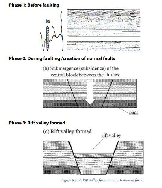
Rift valley is a trough or hollow/depression (graben) which may result from both tensional and compressional forces. It is formed when two faults are developed parallel to each other. The middle part sinks to form the floor of the rift valley. The outer blocks remain standing to form escarpments.
There are various theories put forward to explain the formation of the rift valley and they include: Tensional theory, compressional theory, differential up-lift theory, crustal separation theory and relative sinking theory.
a.Formation of the rift valley by tensional forces (Tensional theory by J.W.Gregory)
A rift valley is formed when tensional forces move away from each other. These tensional forces produce faults and the block (part of the crustal block in the middle) of between two parallel faults subsides to form a rift valley. The outer blocks remain standing to form escarpments.
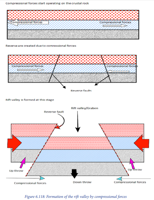
b. Formation of the rift valley by compressional forces (Compressional theory by E.J. Wayland)
Rift valley is formed when horizontal forces act towards each other. These forces push the crustal rocks or layers towards the centre from all sides. These forces of compression produce two parallel faults and the pieces of land on either side are lifted above the general level of the ground to form a rift valley.
c. Theory of differential uplift (by Dixey and Troup)
Rift valley is formed when normal faulting produces several normal fault lines followed by gradual up lift of the faulted area with several step faults. Typical example is Kedong in the part of Nairobi.

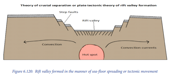
d. Theory of crustal separation/Plate tectonics theory
The theory suggests that the rift valley was formed as a result of sea-floor spreading or tectonic movement, where convectional currents within the mantle rise vertically and then divert from each other horizontally. This results in the dragging of oceanic or continental plates. Such results in the breaking of crustal layers that are dragged apart together with continental rafts. As the movement continued, the central block was forced to subside. Example: along the Atlantic oceanic trench, where the plates continue moving apart.
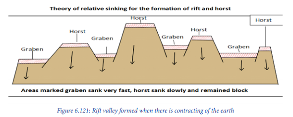
e.Theory of relative sinking (by Suess)
This happens when there is contracting of the earth followed by the fault blocks that are slowly settled. It makes some blocks remaining in the original position (standing up) to form horsts. Others,which are settled faster, form graben or rift valleys. A typical example is the Kamasia ridge in Kenya.
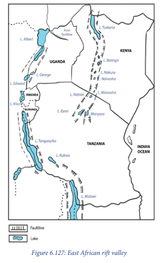
The following are some examples of rift valleys: East African rift valley in Africa; Jordan rift valley in Asia and Rhineland rift valley in Europe.
Block mountain (horst)
A block mountain is an upland bordered by fault scarps on both sides (the block of land between two faults being uplifted because of compressional forces.

The following are some examples of Block Mountains: Cyamudongo, Mishahi, Muzimu, Cyendajuru in the western part of Rwanda; Usambara and Uluguru in Tanzania; Rwenzori in Uganda; Vosges and Black Forest in Europe and Mount Sinai in Asia.
Fault step landscape/tilt block landscape is when vertical tectonic forces push a block of crustal rocks or layers upwards and it happens that some middle parts are pushed higher than others. This is usually because of uneven forces that cause the formation of horst titled landscape characterized by several fault carps (step faults). These can also be formed as a result of differential up-lift.
Fault scarp: An escarpment or cliff/steep slope (a wall of lift valley) formed by a fault that reaches the Earth’s surface. Most fault scarps have been modified by erosion and mass wasting that may reduce the vivid evidences of faulting.
6.3.2. Influence of faulting on drainage
– Faulting influences the drainage pattern in a given area. The different drainage
patterns influenced by faulting include rectangular, parallel and trellised
drainage patterns.
– Most of the time, water passes through the valleys, depressions and fractured
areas hence forming fault guided valleys. A good example is River Rusizi in
western Rwanda.
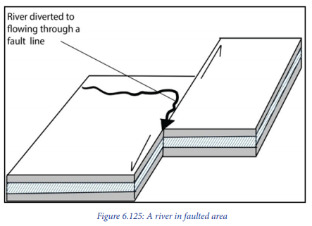
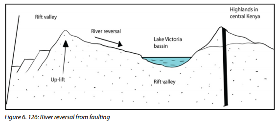
– Faulting leads to river reversal (change of direction). Example of river reversal due to faulting include River Katonga and Kafu in Western Uganda that were joining the Congo river basin and reversed towards Victoria basin. The figure below shows how River Katonga and Kafu changed their flow of direction to Lake Victoria basin as a result of faulting in Western part of Uganda.
– Rift valley lakes are formed when graben or rift valleys are filled by water. Typical examples include: Lake Kivu, Eduard, Albert, George, Tanganyika in the western arm/branch of East African rift valley, Turkana, Manyara, Nyasa, Magadi in the Eastern arm/branch of East African rift valley.
– Some of the waterfalls are in faulted areas e.g. Rusizi, Mururu, water falls in
Rwanda and Mubuku water falls in South Western part of Uganda.
– Faults give rise to the underground water table along fault planes. Typical
examples are Mwiyanike and Nyamyumba in Rwanda.
Application activity 6.3
Explain the influence of faulting on landscape and the drainage system in the context of Rwanda.
6.4. Impact of faulting on human activities
6.4.1. Positive impacts
The positive impacts/effects of faulting to man include:
– Faulted sedimentary strata are good for oil exploration. A good example is oil
deposit from Lake Albert in Uganda.
– Faults give rise to the underground water table along fault planes. This water
is important for agriculture and it is used in industries and domestic activities.
– Faulting leads to the formation of depression which, when filled with water
, form lakes like Kivu, Edward, etc. These lakes are used for fishing, irrigation,
transportation and mining.
– Faulting creates lines of weaknesses in the earth’s crust through which the
underground hot water reaches the surface as hot springs and geysers. These
are sites for geothermal power production. A good example is Nyamyumba
hot spring.
– Faults may also give rise to waterfalls which are used for hydroelectric power
generation.
– Features produced through faulting, for example, fault scarps, rift valleys and
horsts are major tourist attractions.
– Faults play a leading role in the weathering of rocks. The courses of small streams
often follow rock joint systems. This, therefore, facilitates soil formation.
– Some faulted features like rift valley lakes are good sources of minerals like
methane gas from Lake Kivu.
– Faulting exposes mineral bearing layers of rocks, hence facilitating mining. E.g.
copper mining around Mt. Rwenzori in Uganda.
6.4.2. Negative impacts
Below are some of the negative effects/impacts which include:
– Faulting processes result in destructive earthquakes
– Faulting processes change the existing landforms to create the new landforms;
hence deforming the already existing beautiful scenery.
– Faulting processes may result in volcanic eruption which comes along with
ill-effects.
– Fault scarps form topographic barriers that make the development of
infrastructure such as roads and railways difficult.
– Faulted areas are barriers to the development of transport and communication
lines.
– Faulted areas discourage the settlement, agriculture and livestock, industrial
development, etc.
Application activity 6.4
Conduct your own research to assess both the negative and positive impacts of faulting on human beings.
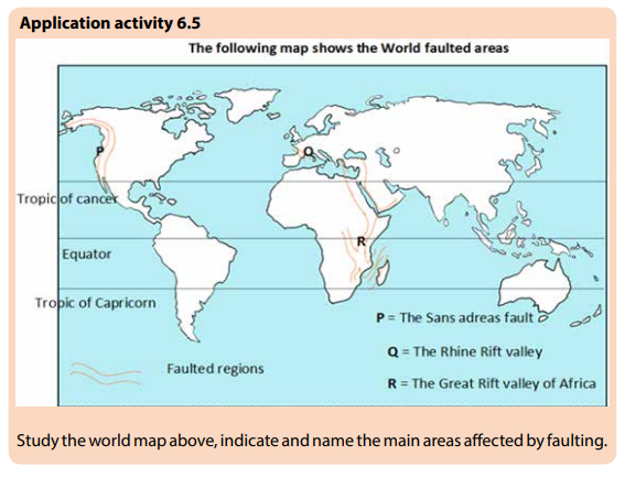
6.5. Distribution of landforms associated with faulting
Learning activity 6.5
1. Draw a sketch map of East Africa, name and locate faulted areas.
2. Identify the world areas that are most affected by faulting outside East
Africa.
Fault areas are mainly located in the following areas:
– East Africa: Faulted areas in East Africa extend from Mozambique in the South
to the Red Sea in the North and from Malawi through Tanzania and Burundi,
then Rwanda to Uganda and Kenya.
– Western Europe: Many faulted areas are in deep oceanic parts of the Atlantic
Ocean in Western Europe.
– The Rhine Rift Valley extends along the border of North East France and South
West Germany.
– The Western Coast of North America, which includes the San Andreas Fault of
California.
– The Alpine fault region in New Zealand in the Far East.
– The North Western highlands of Scotland and the Guadalquir valley of Spain.
6.6. Definition of folding and its process
Learning activity 6.6
Read the passage below and provide answers to the question that follow:
The relief of Rwanda is characterized by six topograhic units that include Bugarama plain and Lake Kivu Banks, Congo-Nile crest, Central plateaus, Eastern low lands, Buberuka region and the Volcanic region. Some of these topographic units were formed through faulting process as it was explained in the previous lesson. Those topographic units formed as a result of faulting include Bugarama plain and Kivu banks. On the other hand, volcanicity has been responsible for the formation of volcanic relief in the North, while the Eastern lowlands resulted from warping. Some landforms of Rwanda were formed through folding processes. Refer to the above presented passage to answer the following questions:
a. Explain the folding processes
b.Differentiate the folding processes from other internal processes in the
passage.
Meaning of folding and folds
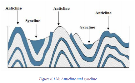
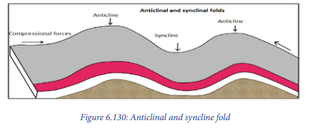
Folding is a process by which crustal rocks bend due to compressional forces. This results from horizontal movements caused by the endogenic forces originating deep within the earth.
Folds are the wave-like bends resulting from folding processes. The up-folded rock strata in arch-like forms are called anticlines, while the down folded structure forming trough-like feature is called syncline. The sides of a fold are called limbs of the fold.
Processes of folding
The processes of folding are mainly engineered by the presence of compressional forces that push intensely the crustal layers/rocks towards a common centre. When crustal parts move towards each other under the influence of horizontal or convergent forces (compressional forces), the crustal rocks undergo the process of ‘crustal bending. The process of folding occurs in areas with soft and young rocks and instead of fracturing due to the internal forces or convectional currents that lead to the formation of compressional forces, the crustal layers start to bend.
Application activity 6.6
Compare the process of faulting and folding in the context of Rwanda.
6.7. Types of folds
Learning activity 6.7:
Referring to the knowledge and skills about folding, describe the characteristics and categories of the limbs, synclines and anticlines formed as result of folding process.
Based on the inclination of the limbs, folds are divided into the following categories:
Symmetrical folds are simple folds whose limbs incline uniformly. These folds are examples of open folds. Symmetrical folds are formed when compressional forces work regularly but with moderate equal intensity. Symmetrical folds are very rare indeed.

Anticlinal fold: This is a fold that has the convex appearance with the oldest beds at its core
A syncline fold: This is a fold with younger layers closer to the folded structure. Synclines are typically a downward fold, termed as syncline (i.e. a trough) but synclines that point upwards or perched can be found when strata have been overturned and folded.
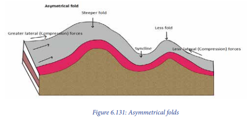
Asymmetrical folds: These are characterized by unequal and irregular limbs. Both limbs incline at different angles. One limb is relatively larger,with moderate and regular inclination, while the other is relatively shorter with steep inclination. Thus, both limbs are asymmetrical in terms of inclination and length. They are formed when compressional forces acting upon the crustal young layers are unequal. One side is intensely pushed while the other is moderately compressed.
Over fold: This is a type of fold formed where the compressional forces push one limb in asymmetrical fold over the other limb at a short distance.

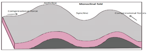
Monoclinal folds: These are folds in which one limb inclines moderately with regular slope while the other limb inclines steeply at the right angle at the slope is almost vertical. Splitting of limbs gives birth to the formation of faults. Also monoclinal folds are formed as a result of unequal horizontal compressional forces coming from both sides.

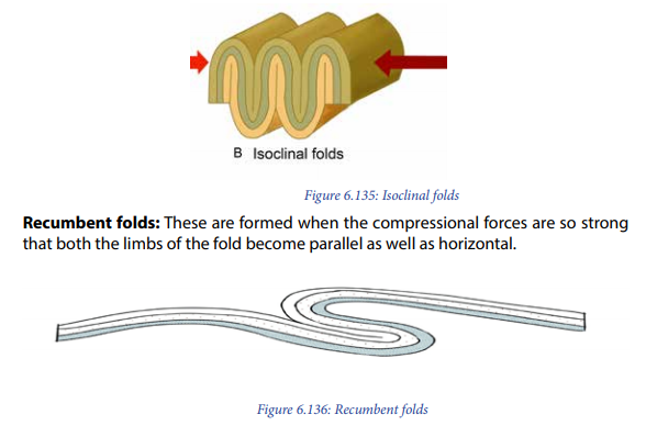
Over thrust / Nappes: These are the results of complex folding mechanism caused by an intense horizontal movement and resultant compressional forces. Both limbs of the recumbent fold are parallel and horizontal. The great intensity of the compressional forces on one limb causes the crest to fracture (Faulting). Therefore, one part of the block jumps over the other.

Isoclinal folds are formed when the compressive forces are so strong that both the limbs of the fold become parallel to each other and not horizontal.
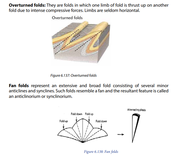
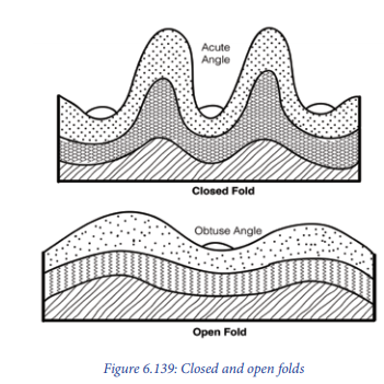
Open folds are those in which the angle between the two limbs of the fold is more than 90o but less than 180o . Such open folds are formed due to wave like folding because of the moderate nature of compressional forces.
Closed folds are the folds in which the angle between two limbs of a fold is acute. Such folds are formed because of intense compressional forces.
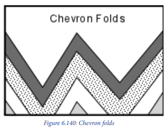
Chevron folds are structural features characterized by repeated well behaved folded beds with straight limbs and sharp hinges. These display a set of repeated set of v-shaped beds.
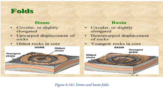
Dome and basin fold:
These are types of folds that display dome-like anticlines instead of arching. Therefore, the fold assumes a dome shape that looks like an inverted bowl. The would-be syncline forms basin like appearance instead of having a sinking arch. A typical example is the Mauritania desert.
Application activity 6.7
With help of digram, differentiate symetrical fold from other type of folds referring to knowledge and skills you gained about folding.
6.8. Influence of folding on the drainage and landscape
Learning activity 6.8
1. Suggest the impact of folding processes on any landscape you have
observed.
2. Assess the impact of folding on the drainage system.
6.8. 1. Influence of folding on drainage
The following are examples of the influence of folding on drainage:
– Folding led to the formation of many waterfalls in Rwanda and elsewhere in
the World. Some of the waterfalls are located on the upward folded areas. A
good example is Rusumo waterfall.
– Fold Mountains are good catchment areas. A typical example in Rwanda is in
Gicumbi District.
6.8.2. Impact of folding on landscape
There are various landforms resulting from folding. They include:
Rolling plains: These types of landforms result from down warping movement caused by the folding processes. They have gently sloping anticlines with very wide synclines.
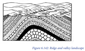
Ridge and valley landscape: The strong compressional forces create a series of asymmetrical folds. The anticlines form the uplands (ridges) while the synclines form the valleys.
Fold Mountains: The most common features resulting from the process of folding are the mountains. The mountains rise to different heights depending on the velocity and intensity of compressional forces.

The following are examples of folded mountains:
– Highlands located in the Northern region of Rwanda (various mountains
located for instance in Gakenke, Musanze, Burera);
– Kigezi highlands in South Western Uganda;
– Caledonian folds: The folds of Caledonia are found in Scotland, and they
affected the Caledonia and Scandinavian countries during the primary era (Paleozoic);
– Hercynian folds, they include: Mountains in Scotland and the Appalachians in
America
– Rockies and Andes in America;
– Insular arcs of the Pacific Ocean;
– Parts of Asia: Japan, Philippines, Kouriles Islands;
– Near the Equator: Marianna, New Zealand, Kermadea;
– Parts of Europe: Alps;
– Parts of South Asia (Saudi Arabia and India);
– North Africa: around the Mediterranean Sea.

6.8.3. Impacts of folding on the physical environment
The above features formed through folding process influence the human activities
positively and negatively as follow:
Positive effects
– Fold Mountains receive heavy rainfall on the windward side hence favouring
crop growing while the leeward side receives little or no rainfall. Thus, there is agriculture and livestock keeping on the windward side;
– Fold mountains are a source of clean water, which is used by human beings;
– The fold mountainous areas can be used for lumbering activities;
– During folding, some valuable minerals are brought closer to the earth’s
surface. This promotes mining activities.
– Some features resulting from folding attract tourists who bring foreign
exchange.
Negative effects
– The Foëhn winds associated with leeward sides in fold mountain areas
discourage the growing of crops, hence hindering agriculture.
– Fold Mountains are barriers to the development of transport and
communication lines. They hinder air transport due to poor visibility;
– The steep and rugged slopes of Fold Mountains discourage settlements,
agriculture and livestock keeping.
– Fold moutains discourages the development of mining sector since some
minerals can be taken deeper into the ground and become hard to exploit
especially in synclinal parts.
Application activity 6.8
1. Conduct your own research to identify both negative and positive
impacts of folding on environment.
2. Assess the significance of fold mountains to the economic development
of Rwanda.
6.9. Meaning, causes and types of warping
Learning activity 6.9
Read the passage below and provide answers to the questions that follow:
The relief of Eastern Rwanda is characterized by low plateaus formed through an
internal process that operate by gentle compressional forces caused by internal
convection currents. That process led to formation of various physical features
namely undulating gentle hills, basin and basin lakes.
a. Identify the process that has been responsible for the formation of
features mentioned in the above passage.
b. Describe how the process of warping occurs.
c. With specific examples; explain the influence of warping on the
drainage system.
6.9.1. Meaning of warping
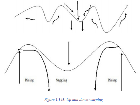
Warping is the downward movement of crustal rocks caused by the sinking of convectional currents within the interior part of the earth. This results in a saucershaped basin. It is produced where only a gentle deformation of crust has taken place over a considerable area and time. It results from the sinking of convectional currents which pull the earth’s crust towards the core. A typical example where warping took place in East Africa is Lake Victoria basin.
6.9.2. Types of warping
There are two types of warping:
Down warping: This is formed when the sinking of convectional currents drag downwards the lower part of the crust. Therefore, the crustal layers bend inwardly to form basins. This created East African major basins i.e. the depressions occupied by Lake Victoria, lake Kyoga in Uganda and Lake Muhazi in Rwanda are good examples.
Up warping: During the down warping, the outer parts of the crustal layers tend to move upwards. This is commonly caused by isostatic movement associated with upward movement. It produced up land regions like East African plateaus and other uplands elsewhere in the world.
Broad warping
When the process of up warping and down warping affects larger areas, the resultant mechanism is called broad warping.
6.9.3. Causes of warping
Warping is mainly caused by convection currents that result in lateral compression forces of low intensity or gentle compressional forces. Typical examples are in East Africa where few areas escaped the down warping and up warping processes. The process led to the formation of Great East African Basin, crustal warped lakes, extensive swamps around the lakes, extensive plateaus, reversal of some rivers, etc.
6.9.4. Landforms associated with warping
The process of warping led to formation of numerous landforms which include:
Plateau: it is a large and extensive uplifted part of the earth’s crust which is almost flat at the top. The top of the plateau is mostly flat (i.e. a plateau is a flat toped hill. Example: Eastern plateaus of Rwanda, the Rwandan part affected by Warping). Other plateaus resulted from warping include: Guinea highlands, Jos plateau, Ahaggar, etc.
Basin: It is a large and extensive depression on the earth’s surface. Most basins are formed due to vertical downward movement of the earth’s crust.
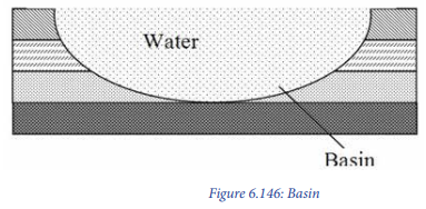
Examples of basins include: An inland drainage e.g. Congo; Chad; and Amazon basins. When a basin is filled by water; it forms basin lakes like Lake Muhazi and Mugesera in Rwanda, Lake Victoria, etc.
Plains: These refer to flat areas that are located in lowland areas. Typical examples are generally in coastal regions that were greatly affected by warping process.
6.9.5. Influence of warping on drainage
Warping plays a major role in the drainage system
– Some rivers change their courses due to warping in a given area. A good
example is the case of hydrography of East Africa where some rivers changed
direction and other filled the depressions to form lakes.
– Warping led to the formation of many lakes in East Africa. Good examples
include: Lake Victoria and Lake Kyoga in Uganda, Lake Muhazi and Mugesera
in Rwanda.
– Some of the waterfalls are located on the upward warped areas.
– The drainage of Rwanda flows from West to East from the up warped features
of Rwanda.
Positive effects
– Upward warping areas receive heavy rainfall on the windward side favouring
crop cultivation.
– The water of river flowing from the warped areas is clean and may be used by
human beings in various activities;
– The upward areas may be used for lumbering activities;
– During warping, some valuable minerals are brought closer to the earth’s
surface. This promotes mining activities;
– Some features resulting from warping attract tourists which bring foreign
exchange.
– Basin lakes stimulate various activities like fishing, water transport and
provision of water for irrigation;
– Hills formed under warping stimulate the development of communication by
favouring the construction of communication masts.
Negative effects
– The destructive Foehn winds are common in warped mountain areas.
– Warped areas are barriers to the development of transport and communication,
where they lead to high cost of the construction of roads.
– The steep and rugged slopes of warped mountains discourage the settlement,
agriculture and livestock keeping.
– During warping, some valuable minerals can be taken deeper into the ground
and become hard to exploit.
Application activity 6.9
1. “Some parts of East Africa have been affected by up warping and down
warping”. With relevant examples support this statement.
2. Draw a sketch map of Rwanda on it label and name the major landforms
which resulted from wraping.
3. Assess the significance of warping on drainage system of East Africa.
6.10. Processes of vulcanicity and volcanic materials
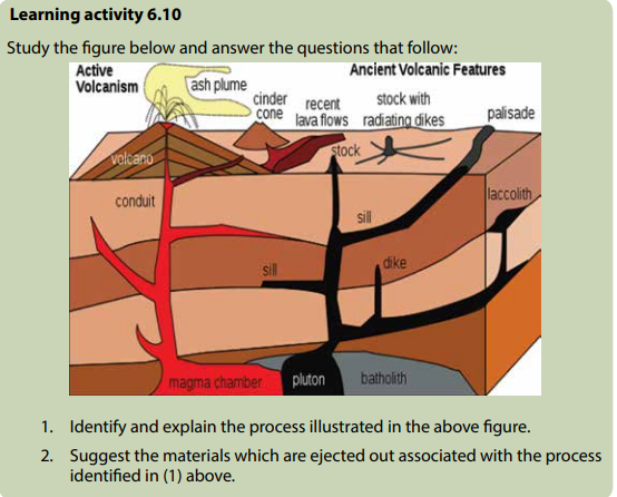
The following are the key terms used in vulcanicity studies:
– Vulcanicity refers to the processes from which the molten materials are either
ejected on the surface of the earth or remain in the earth’s crust.
– Volcanicity refers to the process by which lava through volcanic eruption is
ejected to the earth’s crust.
– A volcano is a mountain that opens downward to a reservoir of molten rock
below the surface of the earth.
Materials of vulcanicity:
Volcanic materials of various types are ejected through the volcanic pipe known as
a vent. This is situated in the part of fault line that assisted the escape of magma.
Volcanic materials include the following:
– Vapour and gases: Stream and vapour include phreatic vapour and magmatic
vapour. Volcanic gases include carbon dioxide, nitrogen oxides, sulphur
dioxide, hydrogen and carbon monoxide.
– Magma and lava: Generally, molten rock materials are called magma when
they are still below the earth’s surface. When they reach the earth’s surface,
they are known as lava. However, when it is still in the mantle it is refer to as
molten material. Lava and magma are grouped into two classes. These include
the following:
a. Based on silica percentage; lava and magma are divided into two
groups: acidic magma (high percentage of silica) and basic lava (low
percentage of silica).
b. Based on light and dark coloured minerals; lava and magma are also
classified into Felsic and Mafic lava.
– Fragmental or pyroclastic materials. These are thrown out during the
explosive type of eruption. They are grouped into three categories:
– Essential materials - consolidated forms of live lava
– Accessory materials - dead lava
– Accidental materials - fragmental materials of crustal rocks.
Based on the size of pyroclastic materials: They are grouped into four kinds:
– Volcanic dust (finest particles)
– Volcanic ash (2 mm in size)
– Lapilli (of the size of peas), and
– Volcanic bombs (6 cm or more in size).
Application activity 6.10
1. Describe the main materials derived from vulcanicity.
2. Name and locate the volcanoes available in Rwanda.
6.11. Intrusive and extrusive features
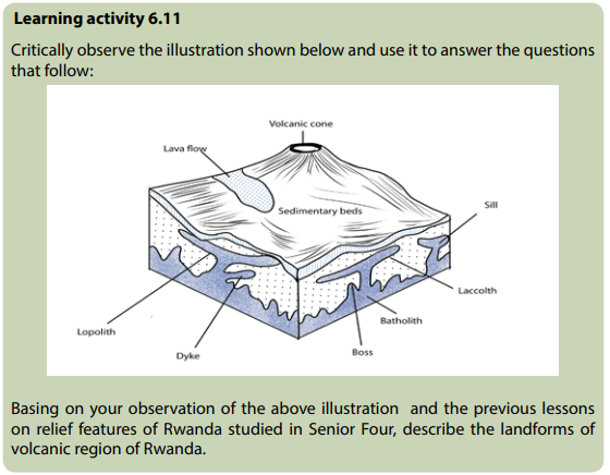
Magma found inside the crust may sometimes reach the surface of the crust through fracture, fissures and consolidate from there. In this case, the features formed are extrusive features. But when the magma fails to reach the earth’s surface and consolidate inside the crust before reaching the surface, the features formed are called intrusive features.
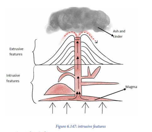
6.11.1. Extrusive volcanic features
These features include the following:
Volcano: This is formed when molten materials escape from the mantle and solidify on the earth’s surface to form a highland known as volcano.
Acidic lava cone: This refers to a cone made of viscous lava normally that is ejected out of the earth’s crust and solidifying faster as soon as it reaches the Earth’s surface. It always cools faster than basic lava because it is viscous in nature.

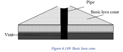
Basic lava cone which is a cone of basic fluid/lava spread over a long distance. Basic lava cone is characterized by gentle slope. Basic lava cone is also known as shield or basalt volcanoes. Typical examples include Nyamuragira in DRC and Muhabura in Rwanda.
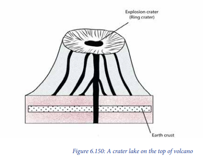
Crater: This is a volcanic depression on top of the volcano. There can be a ring crater or explosive crater in circular shape when a crater is filled by water, it forms a Crater Lake. Examples of crater lakes in Rwanda are found on Kalisimbi, Muhabura and Bisoke volcanoes.
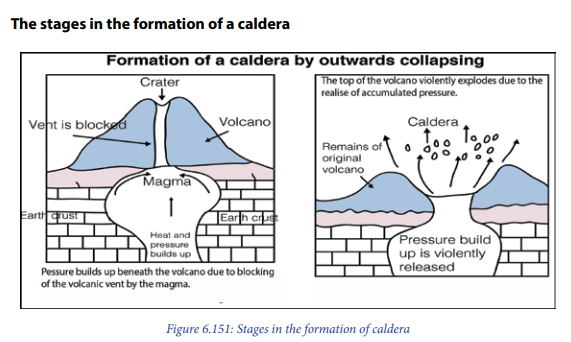
A caldera: This is a wide depression that usually forms on top of a volcanic mountain due to explosive secondary eruption. When a caldera is filled with water, a Caldera Lake is formed. A typical example of dry caldera is Ngorongoro Caldera in Tanzania.
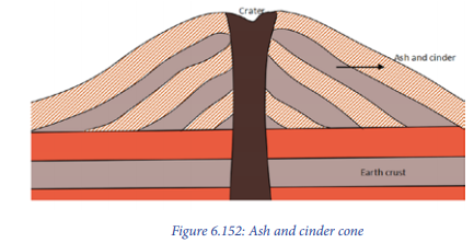
Ash and cinder cone: These are formed when lava is ejected into the air violently and breaks into small particles known as Ash and cinder. These fall back and pile up to form alternating layers of ash and cinder. These have slopes that are importantly concave and asymmetrical in nature.
Volcanic plateaus: These are formed when there are various fissures or vents and basic lava flowing out and spreading to a wide area. This results into the formation of a flat-topped highland known as volcanic plateau.
There are two types of volcanic plateaus which include: Lava plateaus which are formed by highly basaltic lava during numerous successive eruptions through several vents without violent explosions (quiet eruptions). They form an extensive and flat landform. Typical examples of lava plateaus are found in Musanze, Nyabihu, Rubavu, Burera (North West of Rwanda), Ethiopian highlands, Deccan plateau in India and Bui plateau in Nigeria.
The second type of lava plateau is known as pyroclastic plateau which is produced by massive pyroclastic flows and is underlain by pyroclastic rocks. Examples include Shirasu-Daichi in Japan and the North Island Volcanic plateau in New Zealand.

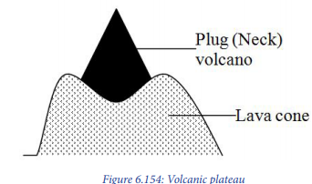
Volcanic plug: This is also called a volcanic neck or lava neck; it is a volcanic feature created when the magma solidifies within a vent and later the soft layers of rocks surrounding it are eroded away. Then, a hard rock in form of a pillar is left standing as a volcanic plug.
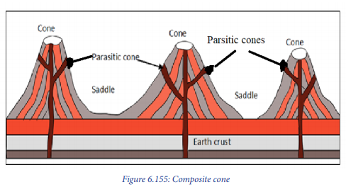
Composite cone: This is a volcano associated with various cones. This is formed when after the formation of the main cone, the magma solidifies in the vent, therefore, blocking it. This forces the active magma for subsequent eruption to find its way out through subsidiary vents along the sides of the cone. This results in the formation of other cones on the sides of the main cone. Examples include, Mt. Kilimanjaro, Mt. Muhabura, etc.
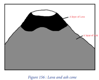
Lava and ash cone or strato volcanoes: They are formed when the lava is violently blown to high heights, breaking into small particles. These fall in the form of Ash. When the pressure reduces, magma comes out gently to form a layer of lava on top of the ash layer. The typical examples include: Muhabura, Elgon, Longonot, etc.
Dissected volcanoes: This is a volcanic mountain that is greatly and deeply affected by serious erosion. A typical example is Mt. Sabyinyo between Rwanda, Uganda and DRC.
Cumulo dome/Volcanic dome/Lava Dome: This is formed when lava is so viscous that it cannot flow away readily. It therefore accumulates around the vent. Hence, a steep sided volcanic dome with no visible crater is formed. Cumulo dome has convex sides.

Explosive crater: This is a depression formed when the pressure reduces and the magma is now subsiding. This means that the crater is occupied by relatively active magma that is under low pressure. It has a circular shape.
Hot spring: This refers to natural outflow of superheated water from the ground. This is formed when the underground water is in contact with superheated rocks associated with the magma. The water heats up, and when it finds its way out, it flows out in the form of Hot spring. It contains mineral substances in solution. Hot springs are found in Iceland, (in Europe), Kenya and Ethiopia (in Africa).
Geysers: These refer to the forceful emission of hot water and steam from the ground to a high level in the air. This is formed in the same way as hot springs, the only difference is that, the super-heated water and steam are realised and ejected out at irregular interval. Geysers are found in Iceland, North Island and New Zealand.
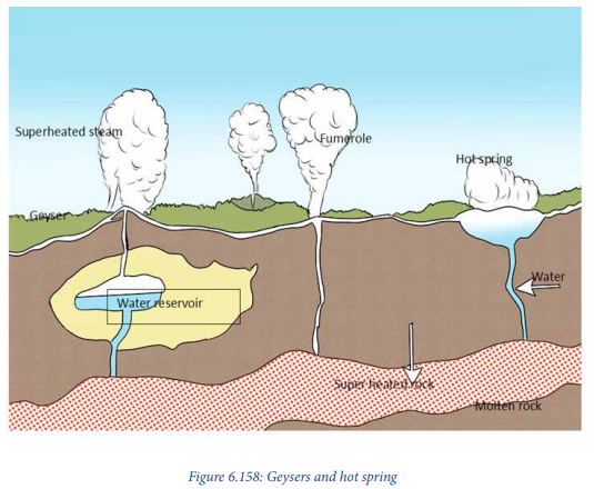
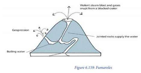
Fumaroles: This is a volcanic feature associated with the emissions of gases from the vents. These gases are composed of steam that continuously comes out from the Earth’s crust in volcanic region. They are formed when the underground water meets the hot magma and creates steam.
6.11.2. Intrusive Vulcanic features
This is a type of vulcanicity where the magma does not reach the earth’s surface but cools and solidifies within the crustal rocks. Intrusive vulcanicity leads to the formation of intrusive features. These features occur beneath the crust and may be exposed to the surface after the overlying rock is removed by erosion. They include: Lava flow, laccolith, Volcano, Dyke, Lapolith, sill, etc.
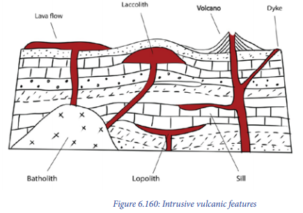
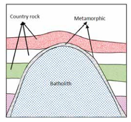
Batholith: This refers to large dome-shaped intrusion of the magma extending to great depth within the earth’s crust. Batholiths are formed deep below the surface when large masses of magma cools and solidifies. These may later be exposed because of erosion to form inselbergs.

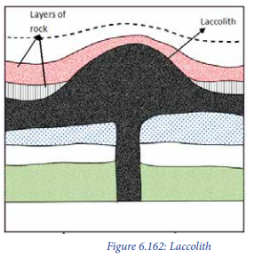
Laccolith: It is a dome-shaped intrusion of the magma formed when the magma cools and solidifies in anticline bedding plane
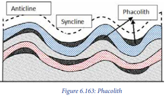
Phacolith: This is lens-shaped mass of igneous rock formed when the magma cools and solidifies at anticline and syncline in folded rocks. Phacolith is much shallower.
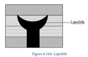
Lapolith: It is a large saucer-shaped intrusion formed when the magma (molten rocks) cools and solidifies in a syncline bedding plane. Lopoliths form shallow basins along the rock bedding plane.
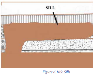
Sills are horizontal intrusions of magma which have solidified along the lines of bedding planes.
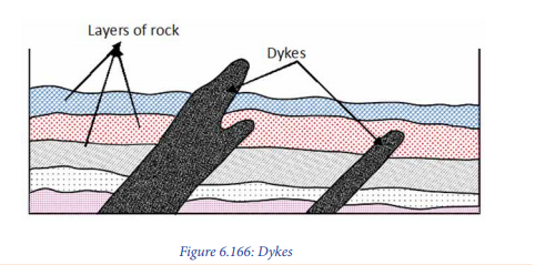
Dykes: These are vertical intrusions formed when magma solidifies in a vertical manner or within the vent and subsidiary vents. They cut across the bedding planes of the crustal rocks into which they have been intruded. Dykes often occur in groups where they are known as dyke swarms.
Application activity 6.11
With the help of diagrams, differentiate intrusive and extrusive volcanic landforms.
6.12. Types of volcanoes and their characteristics
Learning activity 6.12:
In the previous lesson you learnt that volcanicity leads to the formation of various
landforms including volcanoes.
a. Describe volcanoes according to their period of activity.
b. Make a classification of the volcanoes according to their nature of
volcanic eruptions.
A. Classification based on periodicity/ activity of eruptions:
– Active volcanoes: These are volcanoes which constantly eject volcanic lavas, gases, ashes and fragmental materials. They erupted very recently or are engaged in eruption. Examples are Nyiragongo and Nyamuragira in DRC, Ol Doinyo in Tanzania, Lengai, Etna and Stromboli (in Mediterranean Sea).
– Dormant volcanoes: These are the volcanoes which have taken long without erupting but still show signs of eruption. That is, they are quiet after their eruption for some time. However, they suddenly erupt violently and cause huge damage to human, animal and plant life around them. An example is Muhabura, Karisimbi, Gahinga and Bisoke in Rwanda, Vesuvious near Naples in Italy.
– Extinct volcanoes: These are the volcanoes that have taken a long time without erupting and show no signs of erupting in the future.. A good example is Mount Sabyinyo in Rwanda.
B. Classification of volcanoes basing on the nature of eruptions
Based on the nature of eruptions volcanoes are classified into explosive and quiet volcanoes. These include the following:
Explosive type of volcanoes: They are the volcanic eruptions that occur whereby the magma is violently ejected out of the Earth’s crust through a central pipe (vent). This breaks and blows off crustal surface due to violent and explosive gases accumulated deep within the earth.
Explosive type of volcanoes are classified into the following:
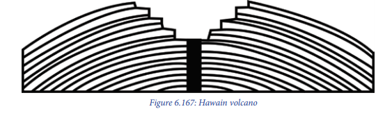
– Hawain type of volcanoes: Such volcanoes erupt quietly due to less viscous lava and non-violent gas. A good example is Nyiragongo of DRC, Mihara in Japan, Etna of Italy, Kilauea of the southern Hawaii island.
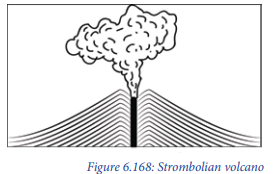
– Strombolian type: Such volcanoes erupt with moderate intensity. Besides lava, other volcanic materials like pumice, scoria and bombs are also ejected into the sky. e.g: Stromboli in Italy.
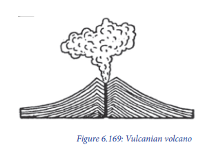
– Vulcanian type of volcanoes: Such volcanoes erupt with great force and intensity. The lava is so viscous and pasty and it quickly solidifies and hardens. It crusts over the volcanic vents. e.g: Lipari in the Mediterranean Sea and Sakurajima in Japan.
– Visuvious type of volcanoes: They are more or less similar to the Vulcanian and Strombolian type of volcanoes. The difference lies only in the intensity of the expulsion of lava and gases. There is a violent expulsion of the magma due to an enormous volume of explosive gases. A good example is the Plini volcano in Italy that erupted in 79 AD.

Fissure eruption type or quit eruption type: These occur along the fracture, fault and fissure and there is slow upwelling of the magma from below and the resultant lava is spread over the ground surface. An example is the Laki fissure eruption of 1783 in Iceland.
Application activity 6.12
With specific examples from East Africa,
a. Identify and describe the extrusive volcanic landforms.
b. Categorize the volcanoes according to their period of activity.
6.13. Influence of volcanicity on drainage
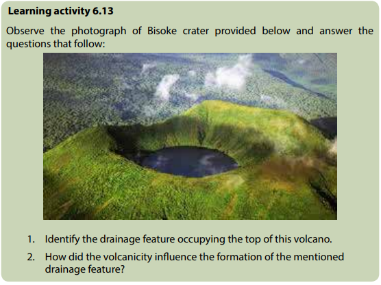
The volcanicity influences the drainage system in a given area in different ways as
follows:
– Some seasonal rivers originate from the craters and flow down slope. A typical
example is Susa River in Rwanda.
– Crater or caldera of volcanoes may be filled with water to form lakes. Good
examples in Rwanda are the lakes located on Bisoke, Muhabura and Kalisimbi

– Some rivers may change their courses due to volcanicity. For example, before
the Rwandan volcanoes came into existence, Nyabarongo River was flowing
northward and then when volcanoes came in place, the river changed its
course and went southward.
– It leads to the formation of lava dammed lakes. E.g. Burera and Ruhondo.

Application activity 6.13
With the help of a sketch of topographical map of Rwanda, examine the relevance of volcanicity on the drainage system of Rwanda.
6.14. Impact of volcanicity on humans
Learning activity 6.14
Using your own experience, textbooks and internet, research on the impact of volcanicity on the social economic development of a country.
Volcanicity has both negative and positive impacts on human life. They include:
Positive impacts
– Volcanicity is associated with rich (fertile) volcanic soils that stimulate
agriculture;
– Volcanicity lead to the production of geothermal heat and geothermal energy;
– Volcanicity stimulate the mining of metal ore deposits (including gold, silver,
copper, tin, iron, lead, wolfram and zinc);
– Volcanicity leads to the formation of crater and lava dammed lakes that
stimulate fishing and water transport. A typical example is in Burera and
Ruhondo lakes in North Rwanda;
– Industrial materials like building stone, Sulphur, pumice and clay are provided
by volcanic features;
– Volcanicity leads to the formation of waterfalls that facilitate the generation
of electricity (HEP). Good examples are Ntaruka and Mukungwa Hydro-power
plants in North Rwanda.
– Volcanoes play a great role in the modification of climate which supports
various human activities such as agriculture.
– The hot springs are used for medicinal purposes, especially in the treatment
of skin diseases.
Negative impacts
– Volcanic eruptions cause heavy damage to human lives and property through
outpouring of lava, fallout of volcanic materials, speeding lava flows etc.
– Too much volcanic materials also lead to the diversion and blocking of drainage
systems and floods.
– The poisonous gases produced during the eruptions may cause acid rain;
– Sometimes volcanic eruptions are followed by heavy rainfall. The heavy rain
mixes with falling volcanic dusts and gases to cause mudflows or lahar;
– Volcanic eruptions may generate tsunamis and seismic waves causing death
to human beings;
– It contributes to the deglaciation because of increasing temperature. The melt
water results in the occurrence of floods and their effects.
– Large quantities of volcanic dust and ashes produced during volcanic eruptions
have been associated with weather and climatic changes. reduces visibility.
– Volcanic eruption affects weather patterns. It is possible that increased volcanic
activity was one of the factors responsible for the little ice Age.
– It off balances the ecosystems and biodiversity in the areas where vulcanism
takes place. For example, Scientists believe that volcanic eruptions and fallout
of dusts and ash, may cause the extinction of several animal and plant species.
Based on this hypothesis the mass extinction of dinosaurs about 60 million
years ago has been linked to an increased volcanic activity.
Application activity 6.14
1. Examine the significance of volcanicity to the economic development of
the areas found in volcanic regions.
2. Assess the role played by volcanicity in the development of the
following economic activities in Rwanda:
a. Tourism industry.
b. Agriculture
c. Power and energy
6.15. World distribution of volcanoes
Learning activity 6.15
1. Conduct your own research and draw the world sketch map showing
areas mostly affected by vulcanicity.
2. Locate the volcanic regions on the East Africa map.
There are three major belts or zones of volcanoes in the world. These are:
a. Circum-Pacific belt: volcanic zones of the convergent oceanic plate margins, including the volcanoes of the Eastern and Western coastal areas of the Pacific Ocean. This includes island arcs and festoons off the East coast of Asia and of the volcanic islands scattered over the Pacific Ocean. This volcanic belt is also called “The fire girdle of the Pacific or the Fire ring of the Pacific”
b. Mid-continental belt, also known as ‘the volcanic zones of convergent continental plate margins’. This belt includes the volcanoes of the Alpine mountain chains and the Mediterranean Sea, and the volcanoes of the faulted zone of Eastern Africa.
c. Mid-Atlantic belt: This includes the volcanoes along the Mid-Atlantic ridge which represents the splitting zone of plates. In other words, two plates diverge in opposite directions from the mid-oceanic ridge. Thus, volcanoes of fissure eruption type occur along the constructive or divergent plate margins.
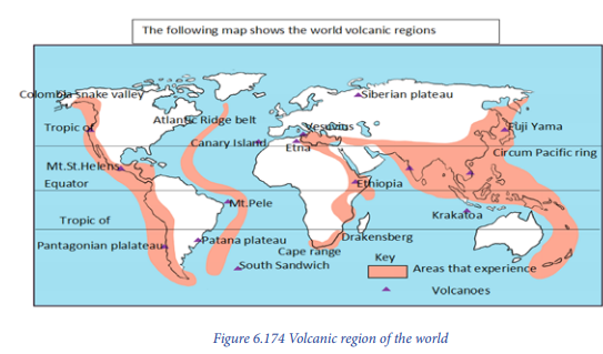
Application activity 6.15:
Locate and describe the major volcanoes of the world on the world sketch map.
6.16. Meaning of Earthquake and its related concepts
Learning activity 6.16
Read the passage about earthquakes occurrence and provide answers to the
questions that follow.
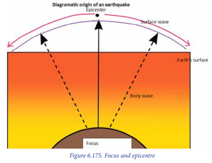
Earthquakes occur when masses of rock in Earth’s crust slip and slide against one another. This kind of movement is most common along a fault, a break in a body of crustal rocks that can extend for kilometers or even hundreds of kilometers. When pieces of crustal rock suddenly slip and move, they release enormous amounts of energy, which then propagates through the crust as seismic waves.
At the Earth’s surface, these waves cause the ground to shake and vibrate, sometimes violently. Geologists classify seismic waves into two broad categories:
body and surface waves. Body waves, which include Primary and Secondary waves, travel through the Earth’s interior. Primary waves resemble sound waves, which means they compress and expand the materials as they pass. Secondary waves resemble water waves, which means they move the materials up and down. Primary waves travel through both the solids and liquids, while Secondary waves only travel through the solids.
1. Identify the internal process explained in the above passage
2. Explain how those processes occur.
3. Explain the types of seismic waves explained in the above passage.
4. Conduct a research and find the meaning of the following terminologies:
– Hypocentre
– Epicentre
– Earthquake
– Focus
– Tremor
An earthquake is a sudden tremble or shaking of the ground caused by abrupt release of energy from crustal rocks; a motion of the ground surface, ranging from a faint tremor to a wild motion capable of shaking buildings and causing gaping fissures in the ground.
– Magnitude
– Intensity
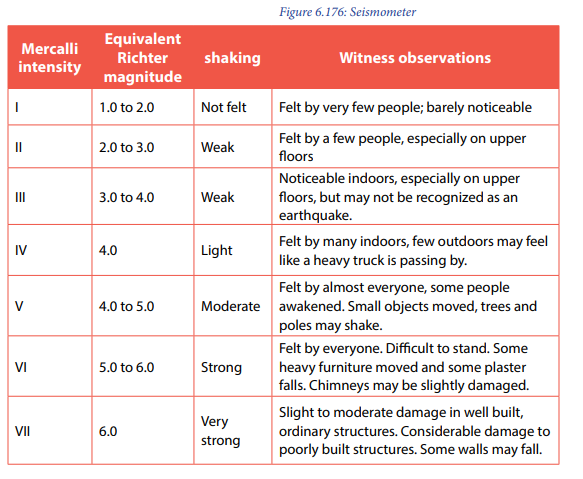
Description of the terminologies associated with Earthquakes:
a. Focus or hypocentre: It is the place of origin of the earthquake and it is
always hidden inside the earth. It is also considered as the place of the
occurrence of an earthquake. The deepest focus has been measured at the
depth of 700 km from the earth’s surface.
b. Epicentre: It is a place on the ground surface which is perpendicular to the
focus. That place is the first to experience seismic event.
c. Magnitude: It is a measure of the amount of energy released during an
earthquake. It may be expressed using several magnitude scales such as
Richter scale and the Mercalli scale.
d. Intensity: It is a number (e.g. V for Mercalli scale and 5 for Richter scale)
describing the severity of an earthquake in terms of its effects on the earth’s
surface, humans and structures such as buildings.
e. Tremors or temblor is the perceptible shaking of the surface of the Earth,
resulting from the sudden release of energy in the earth’s crust that creates
seismic waves.
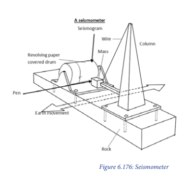
f. Measurement of the Earthquakes:
The intensity or strength of an earthquake is measured using either the Richter
scale or the Mercalli scale. The Richter scale range between 0 and 9. But in the
real sense, the scale has no upper limit because it is a logarithmic scale
The world’s largest and most intensive earthquake recorded had a magnitude of 8.9. The second method of measuring the intensity of an earthquake was invented by Giuseppe Mercalli and it is called Mercalli scale. The intensity is estimated basing on the destruction made by an earthquake. The instrument used in measuring earthquake is seismometer or seismograph.

Application activity 6.16
Through internet, journals, textbooks and magazines search on the earthquakes which affected Western Rwanda in past years. Then answer the following:
1. Name the epicentre of the earthquake which took place in Rwanda in
February, 2007 and August, 2015.
2. Give the intensity on Richter scale of these earthquakes
6.17. Causes, consequences and measures of earthquakes
6.17.1. Causes of earthquakes
Earthquakes are caused by both natural and human factors as follows:
Natural causes of earthquakes
Earthquakes arising from natural causes include:
– Natural earthquakes are caused by natural processes or they are a result of
endogenic forces. Good examples are the earthquakes which took place in
Rwanda in February 2007 and August 2015.
– Volcanic earthquakes are caused by volcanic eruptions of explosive and fissure
types. Generally, volcanic earthquakes are confined to volcanic areas. The
intensity and magnitude of volcanic eruptions is usually high. Examples are
the earthquakes caused by violent explosions of Krakatoa volcano in 1883 and
Etna volcano in 1963.
– Tectonic earthquakes occur because of the dislocation of crustal rock blocks
during faulting. Such earthquakes are severe and disastrous. Examples are the
1872 and 1906 earthquakes of California (USA); 1923 earthquake of Sagami
Bay (Japan); 2001 earthquake of Gujarat in India.
– Isostatic earthquakes are triggered by sudden disturbance in the isostatic
balance at the regional level due to an imbalance in geological processes.
Generally, earthquakes occurring in the active zones of mountains fall in this
category.
– Plutonic earthquakes are deep-focus earthquakes, which occur at greater
depths. The centres (focus) of these earthquakes are generally deep, ranging
from 240km to 670km.
Human causes of earthquakes
The earthquakes may also result from human activities such as:
– Pumping water from underground aquifers, oil reserves; deep underground
mining;
– Blasting of rocks by dynamites for purposes of the construction (of dams and
reservoirs, roads);
– Nuclear explosions;
– Storage of huge volumes of water in big reservoirs.
6.17.2 Consequences of earthquakes
Earthquakes are known to have the following consequences where they occur:
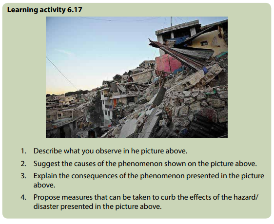
– Loss of life and destruction of property happen when violent shaking of the
land causes cracks on walls and making the buildings to collapse. Vegetation
and the landscape are not spared either.
– Outbreaks of fires occur where the earthquakes destroy oil and gas pipelines.
– Tsunamis are huge and destructive sea waves caused by Earthquakes.
– Landslides occur when the Earthquakes happen. These are sudden movements
of large masses of rock and soil downhill.
– Displacement of crustal rocks. This is caused by Earthquakes. It takes place
vertically and laterally, leading to the damage of transport and communication
lines such as roads, railways, etc.
6.17.3. Measures to curb earthquake effects
It is true that earthquakes lead to the loss of lives and property. Though they cannot
be stopped from occurring, there are several things people can do to reduce such
losses. Such measures include:
– Building houses in a way that they are more resistant to earthquakes.
– During an earthquake and when one is inside a building, he should drop to
the floor and wait until the shaking is over ; and it is safe to move out of the
building.
– When one is outside, he hould stay there or move away from buildings and
streetlights.
– If trapped under a collapsed, structure do not light a match or move about. Tap
on a pipe or wall so that rescuers may get to locate you.
– When the shaking stops, look around to make sure that it is safe to move. Then
leave the building.
Application activity 6.17
It has been noticed that the Western part of Rwanda experiences earthquakes at
a great extent compared to other regions.
a. Suggest why that part of Rwanda experiences such a disaster.
b. What do you think are the effects of such a catastrophe/disaster on
any region where it occurs?
c. Assume that you are in charge of disasters management and
preparedness; suggest the measures that should be taken to control
earthquakes.
6.18. World distribution of Earthquakes
Learning activity 6.18
The most active region in the world associated with Earthquakes corresponds to the margins of the Pacific Ocean. Earthquakes with large magnitudes take place along this zone in the Americas from the Aleutian Islands to Southern Chile and from the Kamchatka peninsula in Asia to New Zealand. Besides shallow earthquakes throughout most of this long region, intermediate and deep shocks take place along the margin of Central and South America and on the other side of the Pacific. This include s the long systems of the island arcs (Aleutians, the Kuriles, Japan the Philippines). Another large seismically active region is known as the Mediterranean-AlpineHimalayas region which extends from West to East from the Azores to the Eastern coast of Asia. This region is related to the boundary between the plates of Eurasia (to the North) and Africa, Arabia, and India-Australia (to the South). A third seismic region is formed by Earthquakes located in the oceanic ridges that form the boundaries of oceanic plates such as the Mid-Atlantic Ridges, East Pacific Rise, etc.
1. Identify the areas affected by Earthquake in the passage above.
2. On the sketch of world map, mark and label the areas that are mostly
affected by earthquakes.
The following are the major seismic zones of the world:
a. Circum-Pacific Belt or Ring of Fire surrounding the Pacific Ocean.
b. Mid-Continental Belt representing epicentres located along the Alpine
Himalayan chains of European and Northern Africa and epicentres of
East African fault zone.
c. Mid-Atlantic Belt representing the earthquakes located along the
mid-Atlantic Ridge and its off-shoots. The high-quality seismicity maps
showed that narrow belts of epicentres coincide almost exactly with
the crest of mid-Atlantic (ridge), the east Pacific, and other oceanic
ridges where plates separate.
d. Volcanic regions of the convergent Oceanic plate margins. These
include the volcanoes of the Eastern and Western coastal areas of the
Pacific Ocean, island arcs and festoons off the East coast of Asia and the
volcanic islands scattered over the Pacific Ocean. This volcanic belt is
also called “the fire girdle of the Pacific or the fire ring of the Pacific.
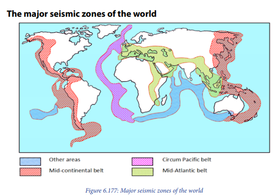
e. Zones of subduction are the biggest crash scene on the earth. These boundaries mark the collision between two of the planet’s tectonic plates. The plates are pieces of crust that slowly move across the mantle’s surface over millions of years. When two tectonic plates meet at a subduction zone, one bends and slides underneath the other curving downwards into the mantle.
Application activity 6.18
With reference and help of a seismic sketch map of Africa, identify the East African areas that are mostly affected by earthquakes.
End unit assessment 6.1
1. Discuss the impact of faulted landforms on the East African landscape
and drainage.
2. Explain the significance of folded relief features in the socio-economic
development of East Africa.
3. With specific examples, explain the importance of warping on drainage
systems of Africa.
4. To what extent has vulcanicity shaped the nature of landscape of East
Africa?
5. Critically examine the effects of either Tsunami in Japan or earthquake
in Haiti on the World economic development.
6. Assume that you are appointed Director General of Rwanda
Environmental Management Authority (REMA), what are the measures
you will take to reinforce the conservation of the basin lakes and
wetlands found in Eastern province.