General
- Geography S5 SB File Uploaded 28/01/22, 13:38
- S5 : Geography TG File Uploaded 19/08/22, 10:37
UNIT 5: THE ORIGIN OF THE EARTH
Key unit competence:
By the end of this unit, I should be able to discuss the theories of the origin of the
Earth.
Introductory activity
Using previous knowledge gained in Geography and other disciplines:
a. Explain how the Earth came into existence.
b. Identify the major characteristics of the earth.
c. Describe the internal structure of the Earth.
d. Find out and describe the various geological eras and periods
recorded in history.
5.1. Theories of the origin of the earth

The formation of the Earth is imbedded in the whole process of the universe formation. The study of the universe is called cosmology. Cosmologists study the structure and the changes that take place in the universe. The universe contains all the star systems, galaxies, gas and dust, and all the matter and energy that exist. The universe also includes all of space and time. The part of the entire universe that we can see is called the observable universe. It can be seen because light from celestial bodies is able to reach the earth. The earth is part of it. Now the big question is to know: what is the origin of the earth? In other words, how the earth came into existence?
The origin of the earth has resulted into many theories that were put forward to explain its possible origin. Eleven theories about the origin of the earth are highlighted below. However, the two first ones - Big Bang theory and Creation theory – seem to be the most accepted.
1. The Big Bang theory
2. The creation or biblical theory
3. The dust cloud theory
4. The Kant-Laplace nebular hypothesis
5. The Chamberlin-Moulton planetesimal hypothesis
6. The Cometary collision hypothesis
7. The Encounter hypothesis
8. The Tidal theory
9. The Fission theory
10. The Accretion theory
11. The Stellar collision theory
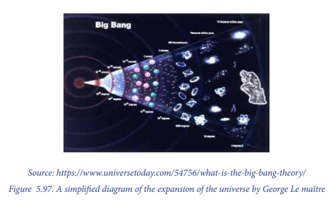
5.1.1. The Big Bang Theory
This theory was first suggested by a Belgian priest named Georges Lemaitre in 1920. He hypothesized that the Universe began from a single primordial atom. This theory further states that in the beginning, there was totally nothing. In about 15 billion years ago a sudden explosion happened (big Bang) which produced a speck of matter that was smaller than an atom. From the time of its formation, this small matter has continued expanding and resulting into the formation of the Earth and all that forms it: the atmosphere, hydrosphere, lithosphere, and biosphere. This theory is criticised on one ground; how can nothing lead to the occurrence of something.
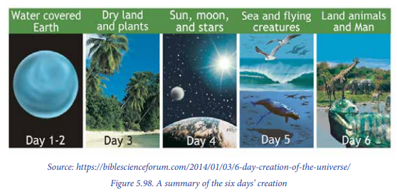
5.1.2. The Biblical or creation theory
The biblical or creation theory is based on the liturgical narrative as expressed in Genesis chapter one of the Holy Bible. It talks about specific acts of divine creation. The theory is believed in by Christians. According to the creation theory, at the beginning there was nothing. The divine power (God) created heaven and earth and all that are in them. The theory holds that God is the master creator of planet Earth and the universe in general. The theory further shows that God created two great lights that is; the greater light which He called Sun and the lesser light which was named the moon. The sun was to provide light during the day and the moon to provide light at night. The whole creation process took place in six days.
– On the first day, God created the day and the night.
– On the second day, He created the sky.
– On the third day, He created the land which is the earth, the sea and the plants.
– On the fourth day, He created the sun, moon and stars.
– On the fifth day, He created the sea creatures and the birds.
– On the sixth day, He created land animals of all kinds and human beings.
Therefore, according to this theory, the Earth and universe were all together created by God.
Application activity 5.1
From the theories that you have learnt above;
a. Explain the difference between the Big bang theory and the Biblical
theory about the origin of the earth.
b. Make a research on other theories of the origin of the earth.
5.2. Characteristics of the Earth
Activity 5.2
Read the passage below and answer the questions asked Far back in ancient times, everybody thought the earth was flat. This is because it looks flat. If you are in a boat way out in the middle of the ocean, the top of the water looks flat in every direction and the sky seems to fit over it like an upsidedown bowl. The line where the sky and water meet is called the “horizon.” The horizon looks like a circle with you yourself at the center. If you are on land, the land stretches out to a horizon also. The horizon on land, however, is not even. It goes up and down because of houses, trees, hills, and other things. Some ancient people suspected that the earth went on forever. They thought it might be a huge flat piece of land and sea with no end at all.
a. What does the story above talk about?
b. How do you find the shape of the earth?
c. Find out the evidences advanced to support the most agreed shape
of our planet.
d. How big is the planet Earth?
5.2.1. The shape of the earth is spherical
1. The shape of the earth
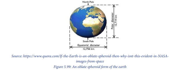
Determining the shape of the earth was a point of concern for many centuries. It was first believed that the earth was flat. This is because the planet appears to be generally flat (not considering mountains and valleys); but the surface of the earth has a slight curve. Further studies based on modern technology proved that the shape of the earth is not a perfect sphere, but an oblate spheroid also known as a geoid. This is because observing the polar areas reveals that they have a flat landscape. At the same time, the equatorial areas have a bulging appearance as shown below:
2. Evidences showing that the earth is spherical
There are several evidences to prove the spherical form of the earth:
– The circumnavigation: If one travelled across the world along the straight path
without stopping would come back to the point of origin where the journey
started from.
– Images from the space: photographs taken from space by satellites show that
the earth’s surface is curved (spherical shape).
– Ride of plane: If on takes a trip, especially for a long destination, 2 interesting
facts are noticed about the planes and the earth:
– Plane can travel in a relatively straight line a very long time and not fall
off any edges;
– If one looks through the window on the trans- Atlantic flight, in most of
the time sees the curvature of the Earth in the horizon.
– The view of other planets: All observations from telescopes reveal that the
planetary bodies are spherical from whichever angle. Therefore, since the
earth is one of them, its shape is also spherical in nature.
– The shadow of the earth during eclipses: The shadow resulting from the eclipse
of the moon (Lunar eclipse) shows that the earth is round.
– Day-night and seasonal change: The earth’s tilted axis produces seasonal
climatic conditions and gives days and night of varying length. If the earth
was at right angles to the sun, the day and the night would always be of equal
length, and there would only be one season throughout the whole year.
– The size and diameter of the earth: The earth has an equatorial diameter of 12,
751 km and its circumference is 40,080 km. These however, are much bigger
than those of the polar areas.
– The International Date Line: if two people started off from the prime meridian
and one went east while another went west, both would meet at the
International Date Line which separates east from west and if they continue
moving, each would end up where they started at the prime meridian.
– The sun rise and sun set: if the earth was flat, the sun would rise and set at
the same time in all countries. But, the sun rises and sets at different times in
different places.
– The polar star: As one moves towards the poles, the size of the polar star
increases and when one moves away from the Polar Regions it decreases. This
means that, the Earth is round. In case it was flat, the size of the polar star
would remain the same or constant.
– The changing altitude of the sun at different times of day: When the sun rises
and sets, it displays a lower sun’s altitude than when it is overhead at mid-day.
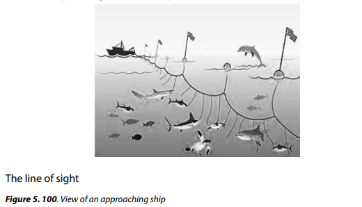
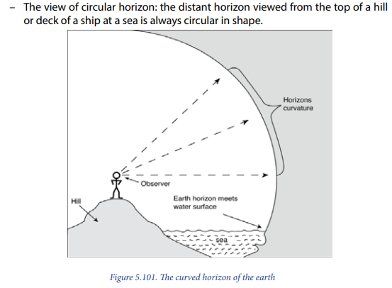
– The ship sailing away from or towards the coast: The lower parts of a ship that is moving away from the coast disappear before the upper parts. On the other hand, on an in-coming ship, the upper parts appear first before other parts of the ship. The figure below helps to understand this evidence:
5.2.2. The shape of the earth is oblate
The earth is slightly flattened at the poles and bulging at the equator. From the outer space, the earth looks perfectly round and smooth. The oblateness of the earth’s shape is more pronounced at the equator due to the earth’s rotation. The bulging at the equator is because of strong centrifugal force at the equator is enough to over-ride the earth’s gravity. Therefore, being able to pull matter away from the centre. The main cause of the flat appearance at the Polar Regions is because of the great gravity existing at the poles due to limited rotational speed. This result into the pulling of matter at the polar regions towards the centre of the earth, hence flattening them.
The following are more details proving that the shape of the earth is not a perfect
sphere:
1. The equatorial diameter is larger than the polar diameter. The diameter of
the Earth at the polar region is 12,713 km, while at the equator it is 12,756
km.
2. The polar circumference is less than that of the equatorial circumference.
The polar circumference is 40,008 km while the equatorial circumference is
40,075 km.
3. Latitudes near the equator are longer than those near the polar areas. For
example, 10 latitude near the equator is 111,926 km, while near the north
pole it is 109,051 km.
4. Areas at the equator are far away from the centre of the earth hence they
have a lower gravity than the areas at the poles. At the poles, the areas are
near the centre of the central part of the earth. This is the reason for the
intense gravitational pull at the poles.
5. Basing on the images taken by the satellites, it has been found out that the
Northern Hemisphere is smaller than the southern hemisphere.
5.2.3. The Earth’s size: radius, diameter, circumference, volume and mass
– The average radius of the earth is 6,371 km.
– The Earth’s equatorial diameter is 12,756 km while the polar diameter is
12,714 km.
– The Earth’s circumference at the equator is 40,075 km. From pole to pole,
its circumference is 40,008 km.

– The Earth’s volume is 1.08321×10¹² cubic kilometres.
– The Earth is the largest of the four inner planets, although it is nothing
compared to the gas giants.
– The Earth’s mass is 5.9736 x 1024 kg.
– The Earth’s density is 5.52 g/cm3. It is the densest planet in the solar system
because of its metallic core and the nature of the content of mantle.
5.2.4 The earth’s gravity
Planets are held in their orbits by the force of gravity. The force pulling the planet is the pull of gravity between the planet and the Sun. when you throw an object into the air, it come back and fall to the ground. This is due to the force of gravity. Normally, the gravity of the earth is approximately 9.8 m/s2. The Earth’s gravity is so intense at the poles because, as mentioned above, such areas are near the centre of the earth than at the equatorial areas. The earth’s gravity at the equator is 9.78m/s2 while at the poles it is 9.832m/s2. In other words, you weigh more at the poles than you do at the equator because of this centripetal force.
The influence of the gravity
The earth’s gravity plays a great role as shown below:
– The density and weight of the materials that compose the interior of the
earth are influenced by gravitational force. Without this force, the interior of the earth would be unconsolidated and easily pulled by the forces of other
heavenly bodies.
– The earth’s gravity glues all materials that form the earth together, hence
forming a single mass called planet earth.
– The gravitational force leads to the occurrence of disturbances in the
asthenosphere which lead to the mobility of the lithosphere. Hence, facilitating
the formation of new features of great importance. This means that the earth’s
surface is always renewed.
– It plays a great role in holding up the organization structure of the solar system.
The constituents of the solar system are held together by the gravitational
pull. O such was not in existence, external gravitational forces could literally
pull components of the solar system including apart, thus destroying them.
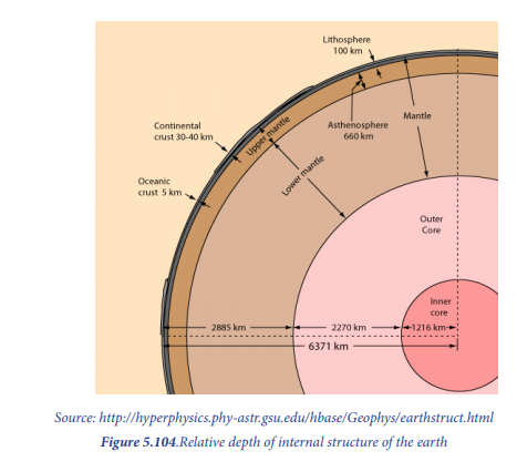
5.3: The internal structure of the earth and mineral composition
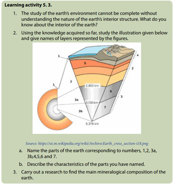
5.3.1. The internal structure of the earth
The layers of the Earth’s interior include the crust, mantle, liquid outer core, and solid inner core. Continental crust has both felsic and mafic rock zones, while oceanic crust has only mafic rock. The interior structure of the earth is layered in concentric shells:
– An outer silicate solid crust.
– A highly viscous mantle.
– A liquid outer core that is much less viscous than the mantle.
– A solid inner core.
The figure below depicts the main layers of the earth’s interior part and their respective properties.
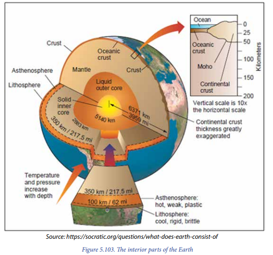
1) The crust
The crust is the outermost layer of the Earth. Various landforms feature like mountains, plateaus and plains, rivers, lakes, sea, oceans and human settlements are found on the crust. It is also referred to as the lithosphere. The crust is divided into two types, the oceanic crust and the continental crust:
– Oceanic crust (SIMA) is a layer consisting mainly of basalt, averaging 6-10 km.
in thickness. At its deepest it has a temperature of 1200° C.
– Continental crust (SIAL) can be up to 70 km thick. The crust separated from
the mantle by the Moho discontinuity. The crust and the rigid lower layer
bordering the mantle are collectively known as the Lithosphere.
2) The Mantle
The mantle is composed mainly of silicate rocks, rich in iron and magnesium. The mantle is under the crust. It is composed of rocks that are in a semi-molten state. These have relatively higher density compared to the rocks that constitute the crust. The mantle has a mean density of 4.6g/cm3. They are mainly composed of Ferro magnesium silicate (iron, magnesium) minerals.
The mantle is divided into three main parts, namely the asthenosphere, the upper
mantle and the lower mantle:
– The asthenosphere: It is a soft layer of the upper mantle, beneath the rigid
lithosphere. It is separated from the crust by the transitional line of discontinuity
called Mohorovicic discontinuity that is shortened the Moho discontinuity.
– The upper mantle: It is a layer of less rigid and more plastic rocks. It extends
from Mohorovicic discontinuity to the depth of 1,000 km.
– The lower mantle: It goes from 1,000 km to 2,900 km in depth. At this depth
the lower mantle is separated from the outer core by a discontinuity surface
called Gutenberg.
3) The core
The core is composed of outer core and inner core. They are mostly constituted by:
– The outer core: Is liquid and kept in a semi-molten state.
– The inner core: Is solid and made mostly of iron and with some nickel (NIFE).
The temperature at the centre of the Earth (6 371 km below the surface) is
about 6200° C (hotter than the surface of the Sun).
The figure below shows the relative depth of different internal layers of the earth.
5.3.2. The mineral composition of the Earth
The mineral composition refers to both the types of minerals within a rock and the overall chemical makeup of the rock. Earth’s rocks are produced by a variety of different arrangements of chemical elements. A list of the eight most common elements making up the minerals found in the Earth’s rocks is described in the table below.
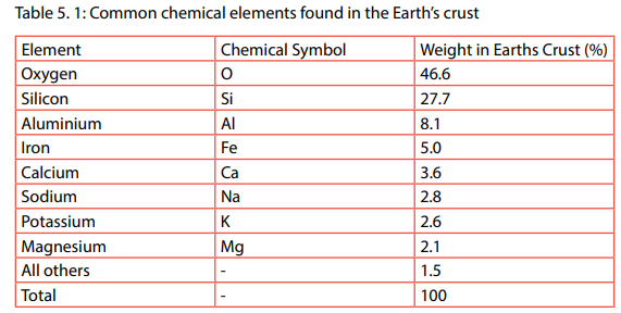
Rocks are classified into three categories: Sedimentary rocks, Metamorphic rocks and Igneous (magmatic) rocks. Each category has its particular mineralogical composition as summarized in the table below.

Application activity 5.3
Apply the knowledge you have acquired in this lesson to answer the following
questions:
1. Suppose you are asked to describe how Mount Muhabura is related to
the internal structure of the earth, what would be your response?
2. The earth’s crust is composed of many minerals. Indicate its most
common chemical elements.
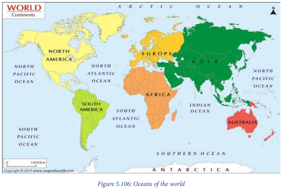
5.4. Superficial configuration of the earth: Continents and Oceans
Superficial configuration refers to the distribution of continents and water bodies especially oceans and seas. Oceans and seas occupy the larger part of the earth’s surface. Therefore, the superficial configuration of the earth means the way parts or elements of the planet earth are arranged on its surface. Superficial configuration deals with the distribution of continents and oceans.
The size of the land surface of planet earth is 148 million km², while the water surface is estimated to be at 363 million km². This shows that the land surface occupies 29 % of the total area of the globe; while the remaining 71 % is composed of water surface coverage.
5.4.1. Continents
A continent refers to the world’s continuous masses of land. The earth is constituted of the following 7 continents: Europe (10,532,000 km2), Asia (44,383,000 km2), Africa (30,330,000 km2), America: North America (24,256,000 km2) and South America (17,819,000 km2), Australia (7,687,000 km2) and Antarctica (14,000,000 km2).
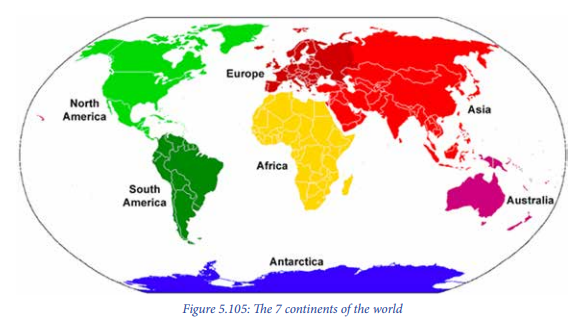
Some Geographers, like Peter George, defined continents as the big land areas surrounded by oceans. Hence, apart from that common assertion of 7 continents, there can be several ways of distinguishing the continents according to the countries:
– Four continents: Afro-Eurasia, America, Antarctica, Australia;
– Five continents: Africa, Eurasia, America, Antarctica, Australia;
– Six continents: Africa, Asia, Europe, America, Antarctica, Australia;
– Six continents: Africa, Eurasia, North America, South America, Antarctica,
Australia/Oceania
– Seven continents: Africa, Asia, Europe, North America, South America,
Antarctica, Australia/Oceania.
5.4.2. Oceans
An ocean is a large mass of saline water. It occupies a basin between continents. An ocean is different from a sea. A sea refers to a relatively large body of the salty water that is completely or partially landlocked. Examples of seas include the Mediterranean Sea, the Black Sea, the Red Sea, the Dead Sea, the Caspian Sea and the North Sea. There are five oceans in the world and they include the following:
– Pacific Ocean: 155 million km2
– Atlantic Ocean: 76 million km2
– Indian Ocean: 68.5 million km2
– Antarctica Ocean: 20 million km2
– Arctic Ocean: 14 million km2
Application activity 5.4
Suppose that the Government of Rwanda has granted the scholarships in the
following countries North Korea, Germany, Japan, Brazil, Senegal and New
Zealand. As you get home your parents ask you:
1. Where the above countries are located? What will be your answer?
2. Describe the world large mass of saline water.
3. With specific examples, explain how water is an important resource.
Describe how it can be conserve.
5.5. Geological time scale
Learning activity 5.5
Read the passage below and answer the questions that follow:
A study of fossils (palaeontology), together with other geological and biological evidence, provides information on the history of Earth and the evolution of life. Fossils provide evidence about the relative ages of rock strata, paleo-environments and evolution of life. The fossil record has been used to develop the worldwide geological time-scale. Organisms may leave traces of their existence in the sediments formed during, or shortly after their lifetimes. As you have learnt early in this unit, the earth is old enough. If you take a journey back through the history of the earth you will get much understanding about this. Every discipline tells you its own story. Then:
1. What does the passage above tell us?
2. Search on internet or other geographical documents on the meaning of
fossils mean.
3. Find out and describe the various geological eras and periods recorded
in history.
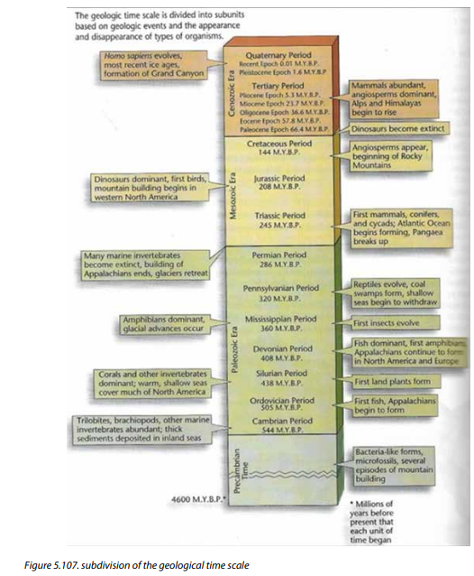
The geological time scale refers to a scheme or chart that indicates age classification of rocks and associated geomorphological and biological events. The earth’s history is divided into smaller units based on the types of life-forms living during certain periods. The division of earth into smaller units makes up Geological time scale. Some of the division in the geologic time scale are also based on geologic changes occurring at that time.
The geological time scale is a record of Earth’s history, starting with Earth’s formation about 4.6 billion years ago. The geological time scale is used by geologists, palaeontologists and other earth scientists to describe the timing and the relationship between events that have occurred throughout Earth’s history.
Subdivision of geological time
There are three types of subdivisions of geological time. These are: Eras, Periods, and Epochs. Eras are major units (subdivisions) of geologic time scale based on differences in lifeforms. There are 3 major eras indicated on the geological time scale. They include the following:
I. Cenozoic (recent life).
ii. Mesozoic (middle life).
iii. Palaeozoic (ancient life).
In table 5.37 The Precambrian time is shown. However, this is not included in eras because it lacks reliable geological evidences.

– Eras are subdivided into Periods (refer to the figure below). Periods are based on
the types of life existing at the time and on geologic events, such as mountain
building and plate movements.
– Periods may be divided into smaller units of time called Epochs. The figure below shows that only the Cenozoic era is subdivided further into epochs. Why is this so? The fossil and geological events records are more complete in these recent rock layers.
Application activity 5.5
Using knowledge and skills acquired from this unit 5, make debate and discussion
to find answers for the following questions:
1. How can archaeological research and environmental protection be
promoted?
2. Explain the importance of Geological time scale.
End unit assessment
Read the following discussion between two students and answer the questions
asked:
1. Two students Mugisha and Uwamahoro were discussing about the
origin of the earth. Mugisha said that the earth and other celestial
bodies came into existence in different ways: some were formed due to
the collision of stars, others by explosion. With confidence, Uwamahoro
said that everything in the universe was created by God.
a. Who is right, who is wrong?
b. Describe four theories of the origin of the Earth
2. The physical features of the earth are changing day by day due to
natural reasons and human activities. Suggest ways people can use to
conserve the nature for its sustainability.