UNIT 8:DRAINAGE SYSTEM IN RWANDA
Key Unit competence: The student-teacher should be able to describe the drainage system of Rwanda and explain its relationship with the human activities.
Introductory Activity
1. Use the map below on drainage of Rwanda and identify the major rivers and lakes of Rwanda.
2. Discuss the major uses of water bodies in Rwanda.
8.1. Major rivers and the drainage basins
Learning activity 8.1
1. Use the map below and identify the major river basin in Rwanda.
2. With examples, classify rivers according to their geographical basins.
Drainage map of Rwanda
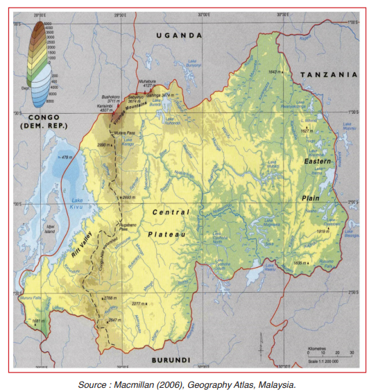
Drainage refers to as the general distribution of surface water. A drainage system is a lay out or actual plan made by a river and its tributaries on the landscape.
The country is drained by numerous rivers and lakes. The drainage system of Rwanda is categorized in two classes according to the direction of flow: The Congo Basin to the West and the Nile Basin to the East. The watershed is a chain of mountain separating two basins. The Congo-Nile peak is the watershed between Congo and Nile water basins.
Water basins and major rivers
The distribution of rivers in Rwanda generally depends on rainfall. Rivers are mainly found in the region of the Congo-Nile peak and the central plateau.
1.1. The Congo Basin
It consists of all rivers in the west mountain region. The western slope of the Congo-Nile peak is drained by a series of rivers flowing into Lake Kivu (inlet of Kivu) namely Sebeya, Koko,Pfunda, Karundura, Kamiranzovu, Kirimbi and Nyabahanga. Rusizi originates from Lake Kivu (Outlet) and pours in Lake Tanganyika. Lukuga River gets its waters from Lake Tanganyika and pours in River Congo.
1.2. The Nile Basin
It is vast and covers ¾ of the Rwandan country. The major rivers which drain it are: Nyabarongo, Akanyaru and Akagera. Akanyaru waters join Nyabarongo in the North-West of Bugesera to form Akagera. The Akagera river first constitutes the border of Rwanda with Burundi and then with Tanzania. At the south-eastern end of Rwanda, Akagera receives water from Ruvubu and flows towards the northern direction forming the border between Rwanda and Tanzania. It then pours into Lake Victoria where the Nile River originates from.
Note that the Birunga volcanic area in the North-West is poor in rivers despite heavy rains. This is due to its lithology which allows deep penetration of water which leads to lack of surface flow.
Application activity 8.1
1. Explain why volcanic region of Rwanda doesn’t have many river sources.
2. Identify the consequence of the uplifting of the Congo-Nile peak on the hydrography of Rwanda.
8.2. Major lakes and their mode of formation
Learning activity 8.2
1. Identify any 5 lakes located in eastern province of Rwanda.
2. What is the largest lake in Rwanda?
8.2.1. Major Lakes of Rwanda
Rwanda is located in the area of the great lakes region.
Lake Kivu
It is the largest water area in Rwanda. It forms the border of Rwanda with D.R.C. Lake Kivu is lodged in a graben. The bottom of Kivu contains methane gas stocks which are evaluated to 5 billion m3 .
The Eastern lakes
They are many and are logded in land depressions. They are not so deep and are surrounded by marshes. These lakes are: Cyohoha south, Muhazi, Ihema, Sake, Mugesera, Rwanyakizinga, Mihindi, Nasho, Rweru, Hago,Cyambwe, etc.
The crater lakes
They are formed by a water mass on top of volcano, in a crater depressed by solidified lava in the vent. Example: Bisoke.
8.2.2. Mode of formation of lakes
Rwanda has got different lakes according to their origin and process of formation as explained below:
Lakes due to Lava damming: These lakes include Burera and Ruhondo. These are lakes formed due to lava damming of some rivers from Rugezi swamp. Water piled behind the barrier forming lakes.
Crater lakes: These are lakes which formed when water accumulated in craters at the tops of volcanoes. Examples of crater lakes are found on volcanoes of Bushokoro, Karisimbi and Muhabura.
Lake due to faulting: This is a lake formed when water accumulated in graben within the rift valley (Lake Kivu).
Lakes due to alluvial deposit: These are lakes which were formed as a result of valley flooding and a result of river reversal (back ponding). Examples include Ihema, Nasho, Rweru, Rwanyakizinga, Hago and others in Eastern province. In the flood plains of river Akagera, numerous small lakes have also formed as a result of river erosion and deposition. Most of such lakes are found in Bugesera and Akagera national park.
Lakes due to subsidence (Warping lakes): These are lakes which formed when water accumulated in down warped depressions especially of Eastern province. Examples include; Lakes Muhazi, Mugesera, Sake, and others.
Ox-bow lakes: These include; lake Bilira, Hago, Mihindi and others In general, an oxbow lake is formed when a river creates a meander as a result of the river’s eroding the bank. After a long period of time, a meander river become strongly curved, and finally the neck of the meander become narrow and the river cuts through the neck during a flood, cutting off the meander and forming an oxbow lake.
Man-made lakes: Examples are found in Eastern province such as Cyabayaga and Rwagitima, Rugeramigozi near Kabgayi in Muhanga district and Mukunguri in Nyanza district
8.2.3. Relationships between the drainage system and the human activities
There is a very close relationship between human activities and water. Sufficient and reliable water supply greatly improve the quality life of people. Humans greatly depend on water in different ways. However, some of the human activities gradually pollute water bodies.
• The availability of water bodies means that family members are easily able to cook, clean themselves and do other domestic work.
• Also the nature of activity and size of family determines how much water is needed at a given time and how frequently available it should be.
• Farming activities depend on water supply especially irrigation farming to ensure high production.
• Excessive use of water on arable farms may lead to scarcity of water in future.
• Afforestation and reforestation practices play a very crucial role in ensuring a continuous rain water supply.
• Presence of places with dense forests and other forms of vegetation act as water catchments.
• Weakness in vegetation conservation may lead to desertification and consequently very little or no water availability.
• It is also important to note that vegetation can not exist if there is lack of water.
Application activity 8.2
1. With examples, explain how people depend on water.
2. Describe human behaviours that cause water pollution.
Skills lab
Despite many water bodies and rainfall in different parts of the country, in Rwanda there is scarcity of water. Suggest what should be done to over-come this situation.
End unit assessment
1. Explain how the major lakes in Rwanda were formed.
2. Explain why most rivers of Rwanda flow eastwards.
3. Water in many places of the world is getting scarce:
a) Discuss the major causes of water shortage in Rwanda.
b) Suggest ways in which people should conserve water as a resource.